2012-14146. Western Pacific Pelagic Fisheries; Modification of American Samoa Large Vessel Prohibited Area
-
Start Preamble
AGENCY:
National Marine Fisheries Service (NMFS), National Oceanic and Atmospheric Administration (NOAA), Commerce.
ACTION:
Final rule.
SUMMARY:
This final rule modifies certain boundaries of the large fishing vessel prohibited area around Tutuila, the Manua Islands, and Rose Atoll in American Samoa to align with the boundaries of the Rose Atoll Marine National Monument. This rule simplifies enforcement and administration of the management areas.
DATES:
This rule is effective July 11, 2012.
ADDRESSES:
The Western Pacific Fishery Management Council (Council) prepared a regulatory amendment that provides background information on this final rule. The regulatory amendment, identified as NOAA-NMFS-2011-0226, includes an environmental assessment and regulatory impact review, and is available from www.regulations.gov or the Council, 1164 Bishop St., Suite 1400, Honolulu, HI 96813, tel 808-522-8220, fax 808-522-8226, www.wpcouncil.org.
Start Further InfoFOR FURTHER INFORMATION CONTACT:
Adam Bailey, Sustainable Fisheries, NMFS PIR, 808-944-2248.
End Further Info End Preamble Start Supplemental InformationSUPPLEMENTARY INFORMATION:
A mix of small troll and longline vessels and larger longline and purse seine vessels target tunas and related fish in the U.S. Exclusive Economic Zone (EEZ) around American Samoa. In 2002, concerns about potential catch competition and gear conflicts between small and large vessels led to the implementation of two large vessel prohibited areas (LVPA), one around Swain's Island and one around Tutuila, the Manua Islands, and Rose Atoll (67 FR 4369, January 30, 2002).
In 2009, Presidential Proclamation 8337 created the Rose Atoll Marine National Monument (74 FR 1577, January 12, 2009). The monument includes Rose Atoll and surrounding waters to a distance approximately 50 nm around the atoll. The Proclamation prohibits commercial fishing in monument waters.
The monument and the LVPA around Tutuila, the Manua Islands, and Rose Atoll overlap, but the boundaries do not align. This rule aligns some of the boundaries to simplify administration and enforcement of the two areas. This rule modifies the LVPA boundaries, as follows:
(a) Move the existing northernmost LVPA boundary southward to align with the northern boundary of the monument;
(b) Move the eastern LVPA boundary eastward to align with the eastern boundary of the monument; and
(c) Move a portion of the southern LVPA boundary southward to align with the southern boundary of the monument.
The western and most of the southern boundaries of the existing LVPA remain unchanged. Fig. 1 shows the revised boundaries of the LVPA.
Comments and Responses
On April 20, 2012, NMFS published a proposed rule and request for public comment (77 FR 23654). The comment period for the proposed rule ended on May 11, 2012. NMFS received no public comments.
Changes From the Proposed Rule
There are no changes in this final rule.
Classification
The Administrator, Pacific Islands Region, NMFS, determined that this action is necessary for the conservation and management of the large vessel pelagic fisheries around American Samoa, and that it is consistent with the Magnuson-Stevens Fishery Conservation and Management Act and other applicable laws.
This final rule has been determined to be not significant for purposes of Executive Order 12866.
The Chief Council for Regulation of the Department of Commerce certified to the Chief Council for Advocacy of the Small Business Administration during the proposed rule stage that this action would not have a significant economic impact on a substantial number of small entities. The factual basis for the certification was published in the proposed rule and is not repeated here. NMFS received no comments regarding this certification; as a result, a regulatory flexibility analysis was not required and none was prepared.
Start Printed Page 34261
Start List of Subjects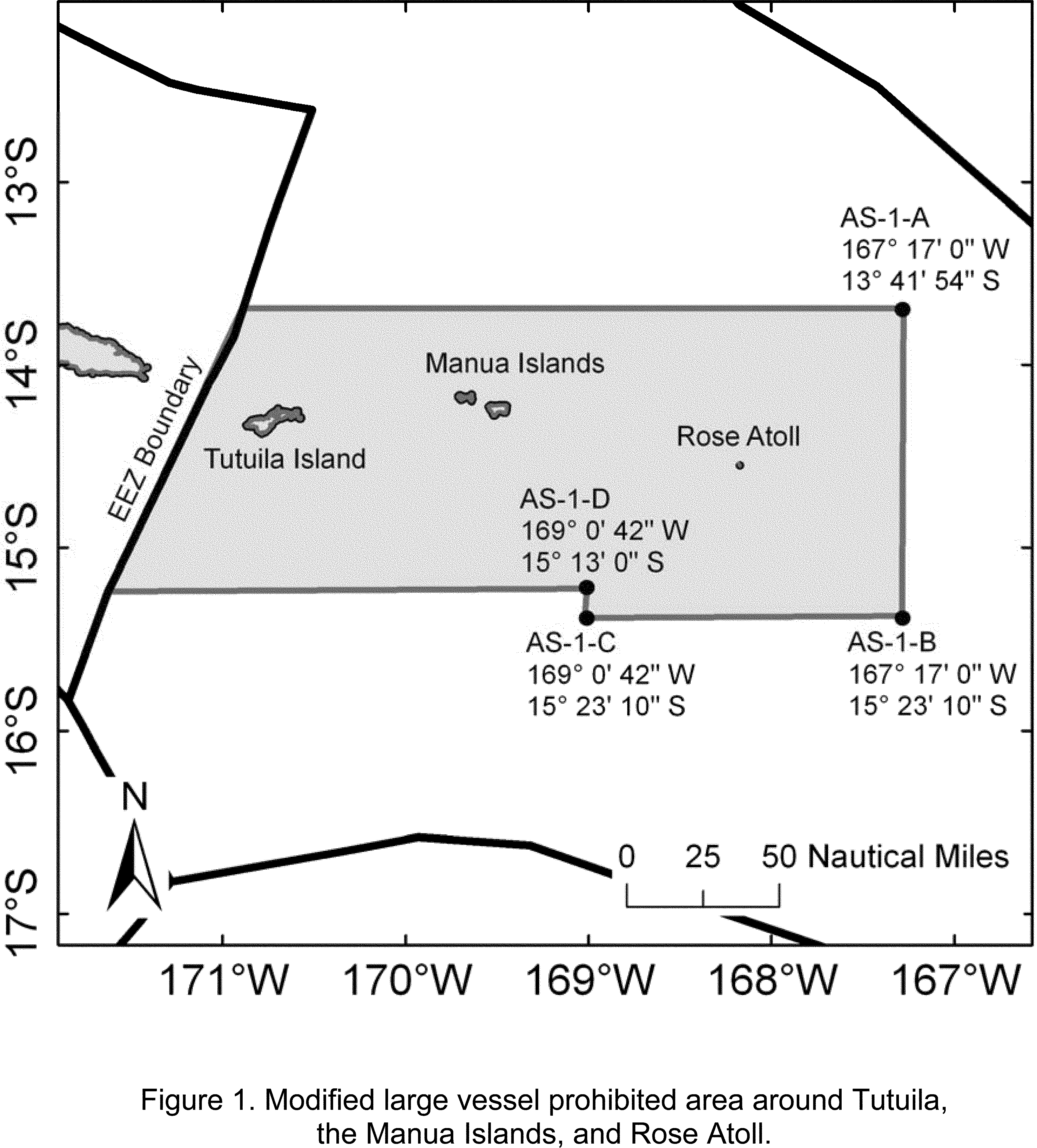
List of Subjects in 50 CFR Part 665
- Administrative practice and procedure
- American Samoa
- Fishing
- Longline
- Marine national monuments
- Prohibited area management
- Purse seine
- Rose Atoll
End SignatureDated: June 5, 2012.
Alan D. Risenhoover,
Acting Deputy Assistant Administrator For Regulatory Programs, National Marine Fisheries Service.
For the reasons set out in the preamble, 50 CFR chapter VI is amended as follows:
Start PartPART 665—FISHERIES IN THE WESTERN PACIFIC
End Part Start Amendment Part1. The authority citation for part 665 continues to read as follows:
End Amendment Part Start Amendment Part2. In § 665.806(b)(1), revise the paragraph and table to read as follows:
End Amendment PartEnd Supplemental InformationProhibited area management.* * * * *(b) * * *
(1) Tutuila Island, Manua Islands, and Rose Atoll (AS-1). The large vessel prohibited area around Tutuila Island, the Manua Islands, and Rose Atoll consists of the waters of the EEZ around American Samoa enclosed by straight lines connecting the following coordinates:
Point S. lat. W. long. AS-1-A 13°41′54″ 167°17′ AS-1-B 15°23′10″ 167°17′ Start Printed Page 34262 AS-1-C 15°23′10″ 169°00′42″ AS-1-D 15°13′ 169°00′42″ and from point AS-1-A westward along latitude 13°41′54″ S. until intersecting the U.S. EEZ boundary with Samoa, and from point AS-1-D westward along latitude 15°13′ S. until intersecting the U.S. EEZ boundary with Samoa. * * * * *BILLING CODE 3510-22-P
BILLING CODE 3510-22-C
[FR Doc. 2012-14146 Filed 6-8-12; 8:45 am]
BILLING CODE 3510-22-P


Document Information
- Comments Received:
- 0 Comments
- Effective Date:
- 7/11/2012
- Published:
- 06/11/2012
- Department:
- National Oceanic and Atmospheric Administration
- Entry Type:
- Rule
- Action:
- Final rule.
- Document Number:
- 2012-14146
- Dates:
- This rule is effective July 11, 2012.
- Pages:
- 34260-34262 (3 pages)
- Docket Numbers:
- Docket No. 110909578-2120-02
- RINs:
- 0648-BB45: Fisheries in the Western Pacific; Changes to American Samoa Large Vessel Prohibited Areas
- RIN Links:
- https://www.federalregister.gov/regulations/0648-BB45/fisheries-in-the-western-pacific-changes-to-american-samoa-large-vessel-prohibited-areas
- Topics:
- Administrative practice and procedure, American Samoa, Fishing
- PDF File:
- 2012-14146.pdf
- Supporting Documents:
- » Amendment 5 - Fishery Ecosystem Plan for Pelagic Fisheries of the Western Pacific
- » Regulatory Amendment including Finding of No Significant Impact, Environmental Assessment, and Regulatory Impact Review
- CFR: (1)
- 50 CFR 665.806