04-1691. Magnuson-Stevens Act Provisions; Fisheries off the West Coast States and in the Western Pacific; Pacific Coast Groundfish Fishery; Groundfish Fishery Management Measures; Correction
-
Start Preamble
AGENCY:
National Marine Fisheries Service (NMFS), National Oceanic and Atmospheric Administration (NOAA), Commerce.
ACTION:
Final rule; correction.
SUMMARY:
This document contains corrections to the emergency rule published on January 8, 2004, for the Pacific Coast groundfish fishery.
DATES:
Effective January 28, 2004, through February 29, 2004.
Start Further InfoFOR FURTHER INFORMATION CONTACT:
Carrie Nordeen or Jamie Goen (NMFS, Northwest Region), 206-526-6140.
End Further Info End Preamble Start Supplemental InformationSUPPLEMENTARY INFORMATION:
The specifications and management measures for the 2004 fishing year (January 1 - December 31, 2003) are initially being published in this Federal Register as an emergency rule for January 1 - February 29, 2004 (69 FR 1322, January 8, 2004) and as a proposed rule for March 1 - December 31, 2004 (69 FR 1380, January 8, 2004).
Management measures for the Pacific Coast groundfish fishery, effective January 1 - February 29, 2004 (69 FR 1322, March 7, 2003), contained errors in the trawl trip limit tables, in the open access table (South), and in the rockfish conservation area (RCA) boundary coordinates around California's Channel Islands that require correction. The trawl trip limit table (North) is revised to clarify that for the DTS complex (Dover sole, thornyheads, sablefish,) small footrope gear restrictions that apply “North or South” refer to north or south of 40°deg;10′ N. lat. The trawl trip limit table (South) is revised to clarify that the trawl RCA between 40°10′ N. lat. and 34°27′ N. lat. is measured from the mainland coast of California and, for January-February, consists of an area between a line connecting latitude and longitude coordinates approximating the 75-fm (137-m) depth contour and a line connecting latitude and longitude coordinates approximating the 150-fm (274-m) depth contour. South of Start Printed Page 408534°deg;27′ N. lat., the trawl RCA has the same boundaries measured from the mainland coast as the area between 40°10′ N. lat. and 34°deg;27′ N. lat., but the RCA is designated around islands as between the shoreline and a line connecting latitude and longitude coordinates approximating the 150-fm (274-m) depth contour. This same revision is made to the open access trip limit table (South) in lines 40-41, which define the trawl RCA for exempted trawl gear. In addition to trip limit tables, the RCA boundary coordinates around California's Channel Islands also require correction. The specific latitude and longitude coordinates that approximate the 150-fm (274-m) depth contour around Santa Catalina Island are corrected to closer approximate the 150 fm (274-m) depth contour and a typographic error in one of the coordinates comprising the RCA boundary approximating the 60-fm (110-m) depth contour around the northern Channel Islands is corrected.
Corrections
In the rule FR Doc. 03-31619, in the issue of Thursday, January 8, 2004 (69 FR 1322) make the following corrections:
Start Amendment Part1. On page 1338, in section IV., under A. General Definitions and Provisions, paragraph (17)(f)(v)(A)(13) is corrected to read as follows:
End Amendment Part* * * * *(13) 34°02.80′ N. lat., 119°21.4′ W. long.;
* * * * *Start Amendment Part2. On page 1350, in section IV., under A. General Definitions and Provisions, paragraphs (17)(f)(ix)(B)(1)-(14) are corrected to read as follows:
End Amendment Part* * * * *(1) 33°17.24′N. lat., 118°12.94′ W. long.;
(2) 33°23.60′N. lat., 118°18.79′ W. long.;
(3) 33°26.00′N. lat., 118°22.0′ W. long.;
(4) 33°27.57′N. lat., 118°27.69′ W. long.;
(5) 33°29.78′N. lat., 118°31.01′ W. long.;
(6) 33°30.46′N. lat., 118°36.52′ W. long.;
(7) 33°28.65′N. lat., 118°41.07′ W. long.;
(8) 33°23.23′N. lat., 118°30.69′ W. long.;
(9) 33°20.97′N. lat., 118°33.29′ W. long.;
(10) 33°19.81′N. lat., 118°32.24′ W. long.;
(11) 33°18.00′N. lat., 118°28.00′ W. long.;
(12) 33°15.62′N. lat., 118°14.74′ W. long.;
(13) 33°16.00′N. lat., 118°13.00′ W. long.; and
(14) 33°17.24′N. lat. 118°12.94′ W. long.
* * * * *Start Amendment Part3. On pages 1364-1367, Table 3 (North) and Table 3 (South) are corrected to read as follows:
End Amendment Part Start Printed Page 4086
Start Printed Page 4087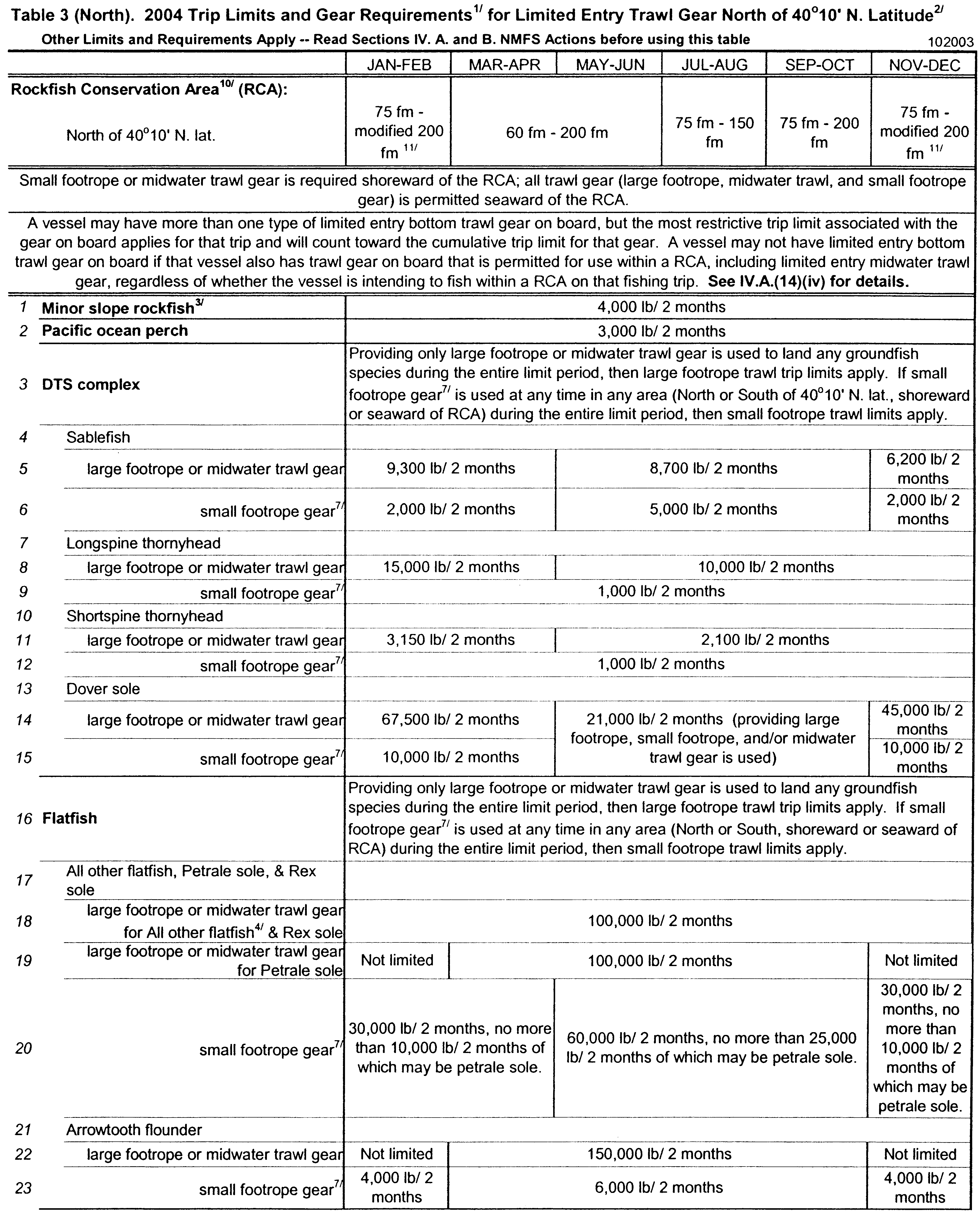
Start Printed Page 4088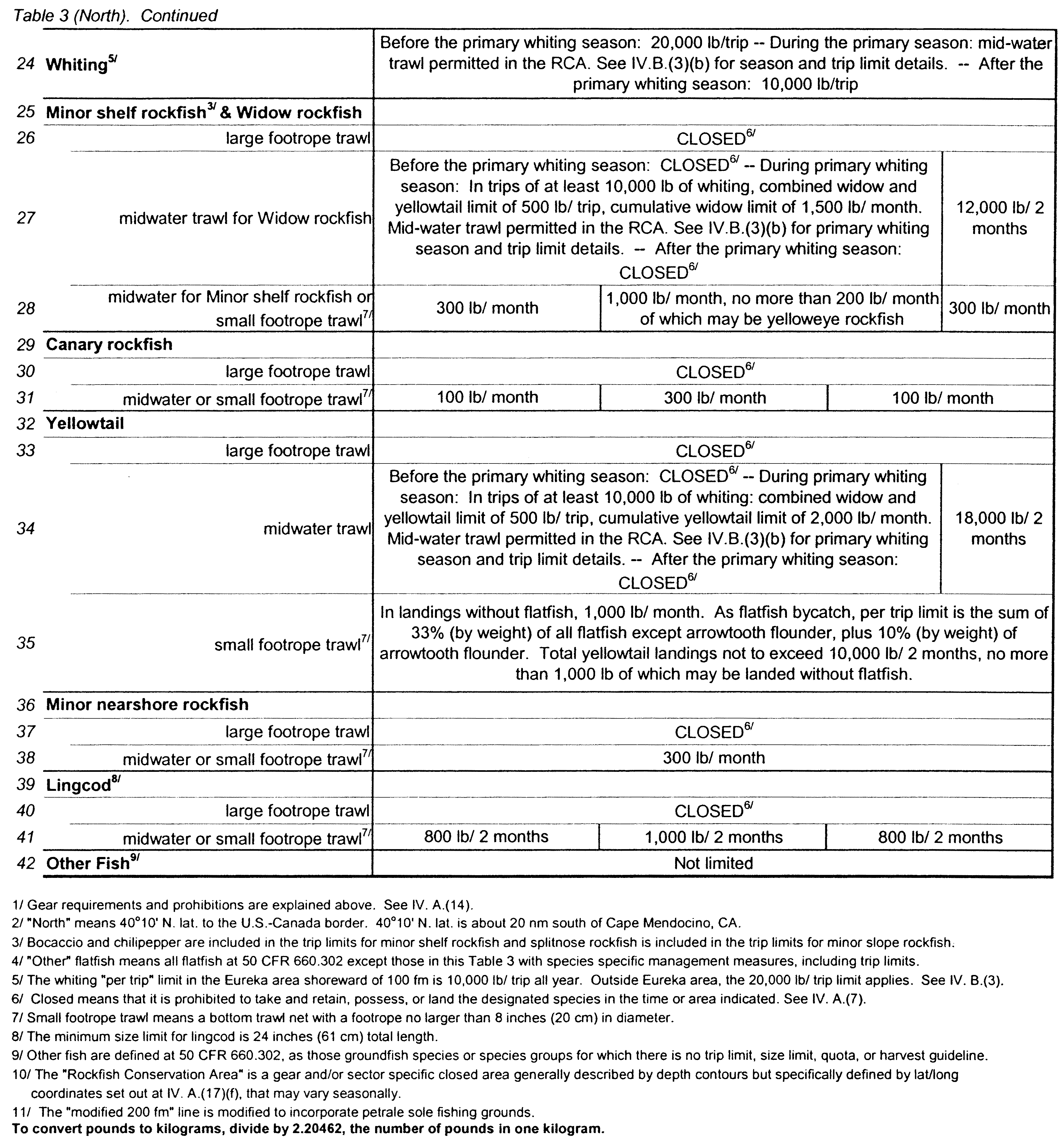
Start Printed Page 4089
Start Printed Page 4090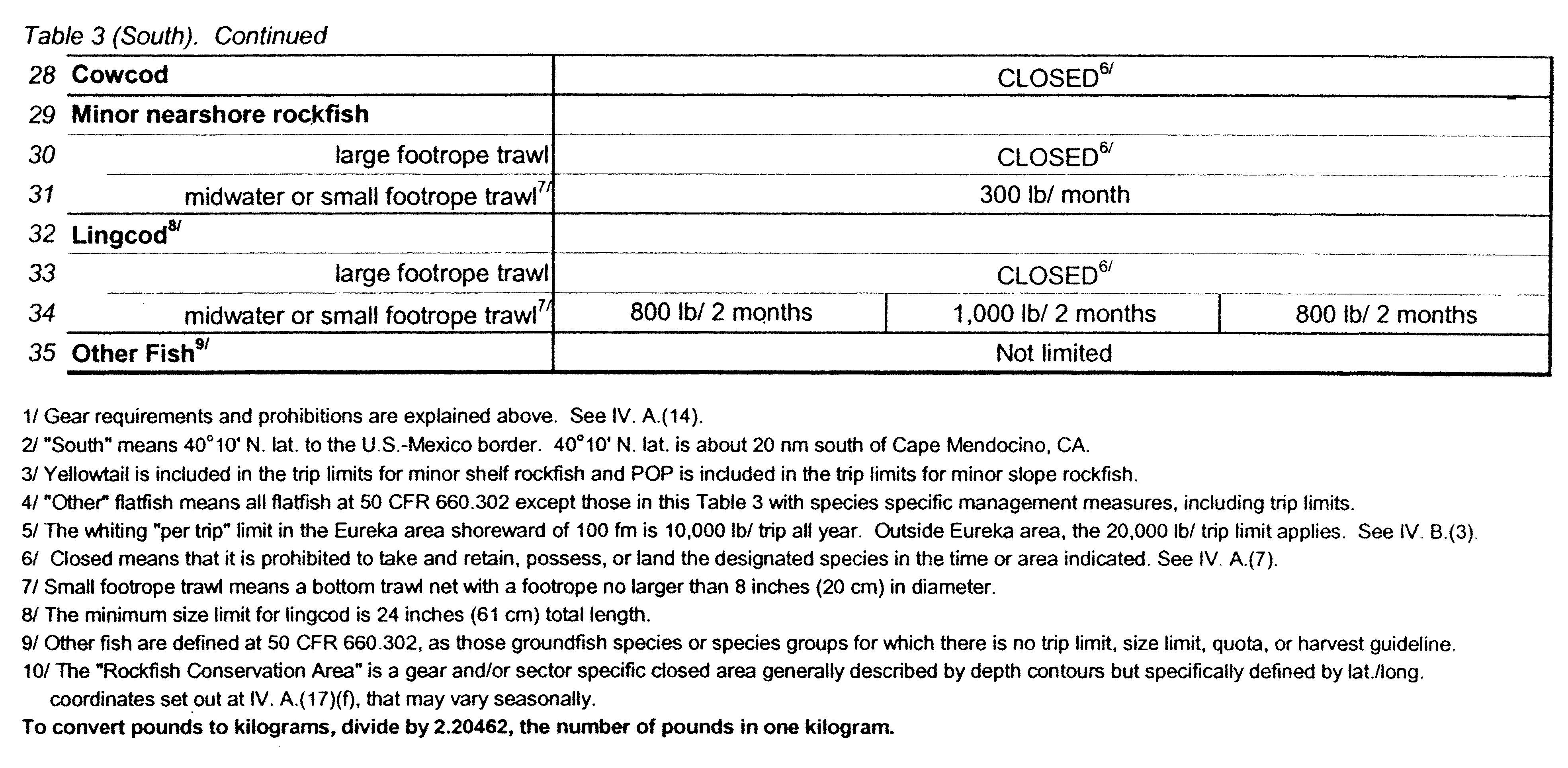 * * * * *Start Amendment Part
4. On pages 1373-1374 Table 5 (South) is corrected to read as follows:
End Amendment Part
Start Printed Page 4091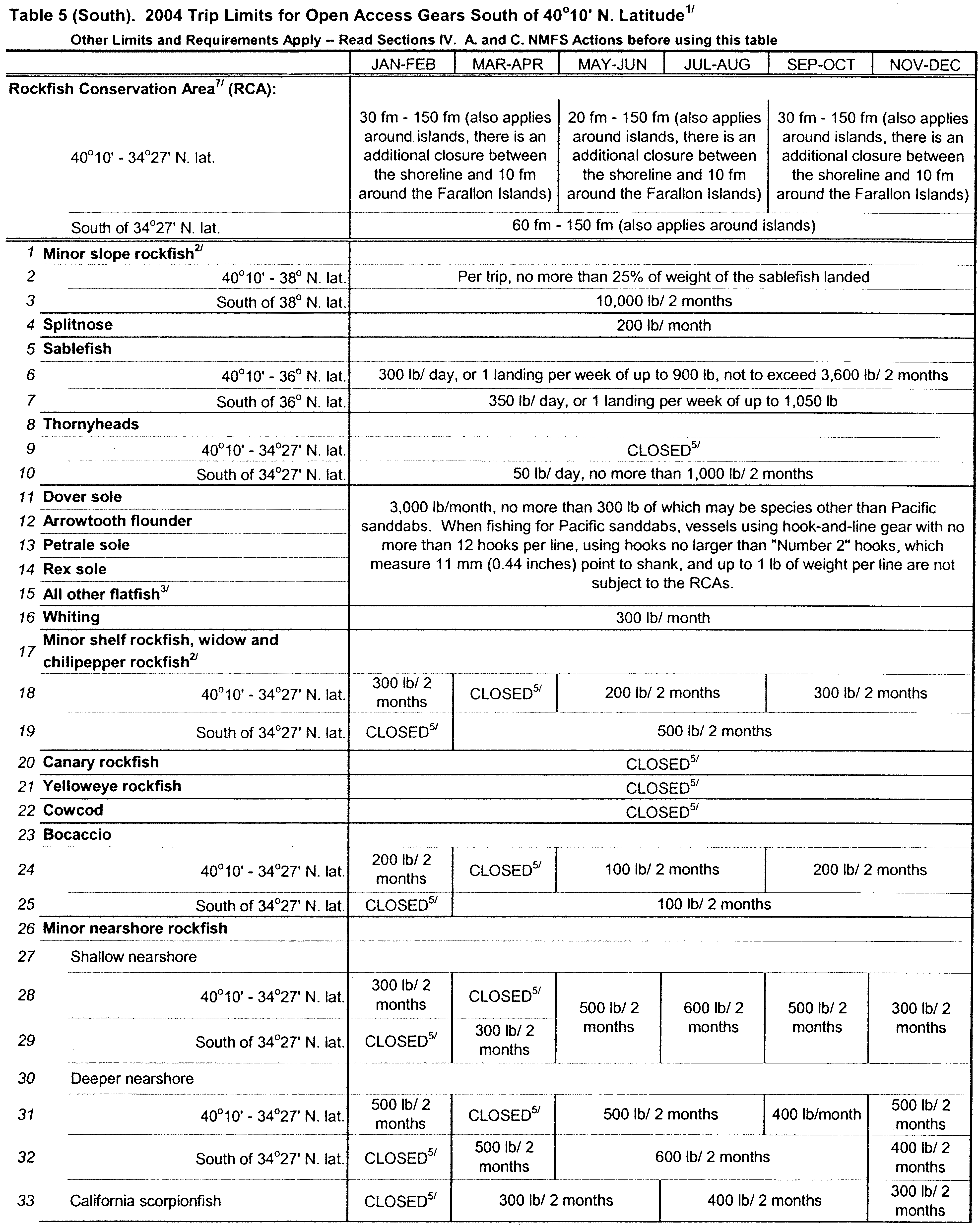
 * * * * *Start SignatureEnd Signature End Supplemental Information
Dated: January 21, 2004.
Rebecca Lent,
Deputy Assistant Administrator for Regulatory Programs, National Marine Fisheries Service.


Document Information
- Effective Date:
- 1/28/2004
- Published:
- 01/28/2004
- Department:
- National Oceanic and Atmospheric Administration
- Entry Type:
- Rule
- Action:
- Final rule; correction.
- Document Number:
- 04-1691
- Dates:
- Effective January 28, 2004, through February 29, 2004.
- Pages:
- 4084-4091 (8 pages)
- Docket Numbers:
- Docket No. 031216315-3515-01 I.D. 112803A
- RINs:
- 0648-AR68
- PDF File:
- 04-1691.pdf
- CFR: (1)
- 50 CFR 660