2014-27113. Endangered and Threatened Wildlife and Plants; Designation of Critical Habitat for Gunnison Sage-Grouse
-
Start Preamble
Start Printed Page 69312
AGENCY:
Fish and Wildlife Service, Interior.
ACTION:
Final rule.
SUMMARY:
We, the U.S. Fish and Wildlife Service (Service), designate critical habitat for the Gunnison sage-grouse (Centrocercus minimus) under the Endangered Species Act (Act). In total, approximately 1,429,551 acres (ac) (578,515 hectares (ha)) are designated as critical habitat in Delta, Dolores, Gunnison, Hinsdale, Mesa, Montrose, Ouray, Saguache, and San Miguel Counties in Colorado; and in Grand and San Juan Counties in Utah. The effect of this regulation is to conserve Gunnison sage-grouse habitat under the Act.
DATES:
This rule becomes effective on December 22, 2014.
ADDRESSES:
This final rule is available on the internet at http://www.regulations.gov and at the Service's species Web site for Gunnison sage-grouse, at http://www.fws.gov/mountain-prairie/species/birds/gunnisonsagegrouse/. Comments and materials we received, as well as supporting documentation used in preparing this final rule, are available for public inspection at http://www.regulations.gov. All of the comments, materials, and documentation that we considered in this rulemaking will be made available by appointment, during normal business hours at the U.S. Fish and Wildlife Service, Western Colorado Field Office, 445 West Gunnison Ave., Suite 240, Grand Junction, CO 81501; telephone 970-243-2778.
The coordinates from which the critical habitat maps are generated are included in the administrative record for this rulemaking and are available at http://www.regulations.gov at Docket No. FWS-R6-ES-2011-0111, at http://www.fws.gov/mountain-prairie/species/birds/gunnisonsagegrouse/,, and at the Western Colorado Field Office (see FOR FURTHER INFORMATION CONTACT). Any additional tools or supporting information that we developed for this critical habitat designation will also be available at the Fish and Wildlife Service Web site and Field Office set out above, and may also be included in the preamble and at http://www.regulations.gov.
Start Further InfoFOR FURTHER INFORMATION CONTACT:
Susan Linner, Western Colorado Supervisor, U.S. Fish and Wildlife Service, Western Colorado Field Office, 445 West Gunnison Ave., Suite 240, Grand Junction, CO 81501; telephone 970-243-2778; facsimile 970-245-6933. If you use a telecommunications device for the deaf (TDD), call the Federal Information Relay Service (FIRS) at 800-877-8339.
End Further Info End Preamble Start Supplemental InformationSUPPLEMENTARY INFORMATION:
Executive Summary
Why we need to publish a rule. This is a final rule to designate critical habitat for the Gunnison sage-grouse. Under the Endangered Species Act of 1973, as amended (16 U.S.C. 1531 et seq.) (Act), any species that is determined to be an endangered or threatened species requires critical habitat to be designated, to the maximum extent prudent and determinable. Designations and revisions of critical habitat can only be completed by issuing a rule.
Elsewhere in today's Federal Register, we, the U.S. Fish and Wildlife Service (Service), publish a final rule to list the Gunnison sage-grouse as a threatened species under the Act. On January 11, 2013, we published in the Federal Register a proposed rule to designate critical habitat for the species (78 FR 2540). Section 4(b)(2) of the Act states that the Secretary shall designate critical habitat on the basis of the best available scientific data after taking into consideration the economic impact, national security impact, and any other relevant impact of specifying any particular area as critical habitat.
The critical habitat areas we are designating in this rule constitute our current best assessment of the areas that meet the definition of critical habitat for Gunnison sage-grouse. Here we are designating approximately 1,429,551 acres (ac) (578,515 hectares (ha)) in six units in Delta, Dolores, Gunnison, Hinsdale, Mesa, Montrose, Ouray, Saguache, and San Miguel Counties in Colorado, and in Grand and San Juan Counties in Utah.
This rule consists of: A final rule designating critical habitat for the Gunnison sage-grouse. The Gunnison sage-grouse is concurrently being listed as threatened under the Act, in a separate rule elsewhere in today's Federal Register. This rule designates critical habitat necessary for the conservation of the species.
We have prepared an economic analysis of the designation of critical habitat. In order to consider economic impacts, we prepared an analysis of the economic impacts of the critical habitat designations and related factors. We announced the availability of the draft economic analysis (DEA) in the Federal Register on September 19, 2013 (78 FR 57604), allowing the public to provide comments on our analysis. We have incorporated the comments into our analysis and have completed the final economic analysis (FEA) concurrently with this final determination.
Peer review and public comment. We sought comments on our proposed critical habitat rule (as well as our proposal to list the species) from independent and appropriate specialists to ensure that our designation is based on scientifically sound data and analyses. We obtained opinions from five knowledgeable individuals with relevant scientific expertise to review our technical assumptions, analysis, and whether or not we had used the best available information. One peer reviewer concluded that our proposals included a thorough and accurate review of the available scientific and commercial data on Gunnison sage-grouse, but did not provide substantive comments. The remaining four letters provided additional relevant information on biology, threats, and scientific research for the species. Two peer review letters were generally in opposition to the proposals and questioned our rationale and determinations. Information we received from peer review is considered and incorporated as appropriate in this final revised designation. We also considered all comments and information received from the public during each comment period.
Previous Federal Actions
Please see the proposed (78 FR 2486, January 11, 2013) and final listing rules (published elsewhere in today's Federal Register) for a history of previous Federal actions related to Gunnison sage-grouse prior to January 11, 2013.
On January 11, 2013, we published in the Federal Register a proposed rule to list Gunnison sage-grouse as endangered (78 FR 2486), and a proposed rule to designate critical habitat for the species (78 FR 2540). We proposed to designate as critical habitat approximately 1,704,227 acres (689,675 hectares) in seven units located in Chaffee, Delta, Dolores, Gunnison, Hinsdale, Mesa, Montrose, Ouray, Saguache, and San Miguel Counties in Colorado, and in Grand and San Juan Counties in Utah. Those proposals initially had a 60-day Start Printed Page 69313comment period, ending March 12, 2013, but we extended the comment period by an additional 21 days, through April 2, 2013 (78 FR 15925, March 13, 2013).
On July 19, 2013, we extended the timeline for making final determinations on both proposed rules by 6 months due to scientific disagreement regarding the sufficiency and accuracy of the available data relevant to the proposals, and we reopened the public comment period to seek additional information to clarify the issues in question (78 FR 43123). In accordance with that July 19, 2013, publication, we indicated our intent to submit a final listing determination and a final critical habitat designation for Gunnison sage-grouse to the Federal Register on or before March 31, 2014.
On September 19, 2013, we announced in the Federal Register the availability of the draft economic analysis and a draft environmental assessment prepared pursuant to the National Environmental Policy Act (NEPA) for the proposed critical habitat designation, and reopened the public comment period until October 19, 2013 (78 FR 57604). The draft economic analysis (IEc 2013, entire) was prepared to identify and evaluate the economic impacts of the proposed critical habitat designation. We also reopened the public comment period from November 4, 2013, through December 2, 2013, and announced the rescheduling of three public hearings on the proposed listing and critical habitat rules due to delays caused by the lapse in government appropriations in October 2013 (78 FR 65936, November 4, 2013). All substantive information received during all public comment periods related to the critical habitat designation, economic analysis, and environmental assessment have been incorporated directly into the final versions of those documents, or addressed below (see Peer Review and Public Comments).
On February 11, 2014, we announced a 6-week extension to May 12, 2014, for our final decision on our proposed listing and critical habitat rules (USFWS 2014e). This extension was granted by the Court due to delays caused by the lapse in government appropriations in October 2013, and the resulting need to reopen a public comment period and reschedule public hearings. On May 6, 2014, we announced a 6-month extension to November 12, 2014, as approved by the Court, to make our final listing and critical habitat decisions (USFWS 2014f).
Summary of Changes From Proposed Rule
- We refined some critical habitat boundaries based the most recent occupied habitat spatial layers by Colorado Parks and Wildlife (CPW). We also modified the unoccupied habitat in the Sanborn Park/Iron Springs area to better match CPW's mapping. We also deleted one unoccupied polygon (Bostwick Park) in the Cerro Summit area based on the low likelihood of this area supporting birds.
- Although we previously proposed designating a critical habitat unit in Poncha Pass, information received since the publication of the proposed rule has caused us to reevaluate the appropriateness of including the unit. Poncha Pass is thought to have been part of the historical distribution of Gunnison sage-grouse. There were no grouse there, however, when a population was established via transplant from 30 Gunnison Basin birds in 1971 and 1972. In 1992, hunters harvested at least 30 grouse from the population when CPW inadvertently opened the area to hunting. We have no information on the population's trends until 1999 when the population was estimated at roughly 25 birds. In one year, the population declined to less than 5 grouse, when more grouse were brought in, again from the Gunnison Basin, in 2000 and 2001. In 2002, the population rose to just over 40 grouse, but starting in 2006, the population again started declining until no grouse were detected in lek surveys in the spring of 2013 (after publication of the proposed critical habitat rule). Grouse were again brought in in the fall of 2013 and 2014 and six grouse were counted in the Poncha Pass population during the spring 2014 lek count (CPW 2014d, p. 2); however, no subsequent evidence of reproduction was found. We now conclude that the Poncha Pass area, for reasons unknown, is not a landscape capable of supporting a population of Gunnison sage-grouse and therefore does not meet primary constituent element (PCE) 1. As a result, we have determined that the Poncha Pass area should not be designated as critical habitat, and have therefore removed this proposed critical habitat unit from the final critical habitat designation.
- Based on peer review and public comments and our analysis, this final rule excludes specific properties from the critical habitat designation under section 4(b)(2) of the Act, namely private lands enrolled in the Gunnison Sage-grouse Candidate Conservation Agreement with Assurances (CCAA) as of the effective date of this rule, private lands under permanent conservation easement (CE) as of August 28, 2013 as identified by Lohr and Gray (2013), and private land owned by the Ute Mountain Ute Tribe under restricted fee status that is subject to a species conservation plan as of the effective date of this final rule (see Exclusions). These private land exclusions reduced the total critical habitat designation from 1,621,008 ac (655,957 ha) to 1,429,551 ac (578,515 ha) (see Table 1).
- We modified the boundaries of this critical habitat designation around the City of Gunnison. We refined the boundary to leave out areas of medium- to high-intensity development, airport runways, and golf courses. In all other areas, lands covered by buildings, pavement, and other manmade structures, as of the effective date of this rule, are not included in this designation, even if they occur inside the boundaries of a critical habitat unit, because such lands lack physical and biological features essential to the conservation of Gunnison sage-grouse, and hence do not constitute critical habitat as defined in section 3(5)(A)(i) of the Act.
- Based on comments and recommendations received by peer reviewers and the public, in this final rule, we refined our description of the PCEs (see Primary Constituent Elements for Gunnison Sage-grouse) and have provided more detailed background and rationale for the criteria and methods used to identify and map critical habitat (see Criteria and Methods Used to Identify and Map Critical Habitat).Start Printed Page 69314
Start Printed Page 69315Table 1—Size and Current Occupancy Status of Gunnison Sage-Grouse in Proposed and Final Designated Critical Habitat Units a
Critical habitat unit Proposed critical habitat Final critical habitat without exclusions Final critical habitat with exclusions Ac Ha Occupied? Ac Ha Ac Ha Occupied? Ac Ha Ac Ha Occupied? Ac Ha Monticello-Dove Creek 348,353 14,097 Yes 111,945 45,303 348,949 141,214 Yes 112,543 45,544 343,000 138,807 Yes 107,061 43,326 No 236,408 95,671 No 236,405 95,670 No 235,940 95,481 Piñon Mesa 245,179 99,220 Yes 38,905 15,744 245,925 99,522 Yes 44,678 18,080 207,792 84,087 Yes 28,820 11,663 No 206,274 83,476 No 201,247 81,442 No 178,972 72,424 San Miguel Basin 165,769 67,084 Yes 101,371 41,023 143,277 57,982 Yes 101,750 41,177 121,929 49,343 Yes 81,514 32,988 No 64,398 26,061 No 41,526 16,805 No 40,414 16,355 Cerro Summit-Cimarron-Sims Mesa 62,708 25,334 Yes 37,161 15,038 56,541 22,881 Yes 37,161 15,039 52,544 21,264 Yes 33,675 13,628 No 25,547 10,339 No 19,380 7,843 No 18,869 7,636 Crawford 97,123 3,930 Yes 35,015 14,170 97,124 39,305 Yes 35,015 14,170 83,671 33,860 Yes 32,632 13,206 No 62,109 25,134 No 62,109 25,134 No 51,039 20,655 Gunnison Basin 76,802 298,173 Yes 592,952 239,959 729,194 295,053 Yes 592,168 239,600 620,616 251,154 Yes 500,909 202,711 No 143,850 58,214 No 137,027 55,453 No 119,707 48,444 Poncha Pass 48,292 19,543 Yes 20,416 8,262 No 27,877 11,281 Not included in the final critical habitat designation All Units 1,704,227 689,675 Yes 937,765 379,499 1,621,008 655,957 Yes 923,314 349,238 1,429,551 578,515 Yes 784,611 317,521 No 766,463 310,176 No 697,694 306,719 No 644,940 260,994 a Numbers may not sum due to rounding. Peer Review and Public Comments
In our January 11, 2013, proposed rules for Gunnison sage-grouse (proposed listing, 78 FR 2486; and proposed critical habitat designation, 78 FR 2540), we requested written public comments on the proposals. We requested written comments from the public on the proposed designation of critical habitat for the Gunnison sage-grouse during four comment periods, spanning from January 11, 2013, to December 2, 2013 (see Previous Federal Actions). We also requested comments on the associated draft economic analysis and environmental assessment during two of those comment periods (see Previous Federal Actions). We contacted appropriate State and Federal agencies, county governments, elected officials, scientific organizations, and other interested parties and invited them to comment. We also published notices inviting general public comment in local newspapers throughout the species' range. From January 11, 2013, to December 2, 2013, we received a total of 36,171 comment letters on both proposals. Of those letters, approximately 445 were substantive comment letters; 35,535 were substantive form letters; and 191 were non-substantive comment letters.
Substantive letters generally contained comments pertinent to both proposed rules, although the vast majority of comments were related to the proposed listing rule. Responses to comments related to the listing rule are provided in the final rule to list Gunnison sage-grouse as threatened, published elsewhere in today's Federal Register. Also, three public hearings were held November 19-21, 2013, in response to requests from local and State agencies and governments; oral comments were received during that time (see Previous Federal Actions). All substantive information related to critical habitat provided during the comment periods has been incorporated directly into this final rule or addressed below. For the readers' convenience, we combined similar comments and responses.
Peer Review
In accordance with our peer review policy published in the Federal Register on July 1, 1994 (59 FR 34270), we solicited and received expert opinion from five appropriate and independent individuals with scientific expertise on Gunnison sage-grouse biology and conservation. The purpose of the peer review is to ensure that our decisions are based on scientifically sound data, assumptions, and analyses, based on the input of appropriate experts and specialists. We received written responses from all five peer reviewers. We reviewed all comments received from the peer reviewers for substantive issues and new information regarding critical habitat for the Gunnison sage-grouse. One peer reviewer concluded that our proposals included a thorough and accurate review of the available scientific and commercial data on Gunnison sage-grouse, but did not provide substantive comments. The remaining four letters provided additional relevant information on biology, threats, and scientific research for the species. Two peer review letters were generally in opposition to the proposed listing and critical habitat designation and questioned our rationale and determinations. All substantive comments from peer reviewers related to critical habitat are incorporated directly into this final rule or addressed in the summary of comments below. For the readers' convenience, similar comments and responses are combined.
Comments From Peer Reviewers
(1) Comment: One peer reviewer commented that we should consider including measures of residual grass cover and height in the assessment of breeding habitat within the PCEs for Gunnison sage-grouse critical habitat.
Our response: As described in this final rule, habitat structural values for breeding habitat (PCE 2) are based on the Gunnison Sage-grouse Rangewide Conservation Plan (RCP) and are considered average values over a given project or area (Gunnison Sage-grouse Rangewide Steering Committee (GSRSC) 2005, p. H-6). This comprises the best available information for breeding habitat requirements of Gunnison sage-grouse. The RCP does not specifically define minimum residual grass cover or height (remaining seasonal vegetation following livestock grazing) or grazing management for breeding habitats. However, the PCE 2 includes habitat structural guidelines that require appropriate and cognizant management (i.e., related to livestock grazing and forage utilization levels) to ensure that adequate residual grass cover and height are achieved and maintained. Thus, we conclude that the PCEs indirectly address residual grass cover and height requirements for Gunnison sage-grouse. This topic is discussed further in the Primary Constituent Elements for Gunnison Sage-grouse section of this final rule.
(2) Comment: A peer reviewer stated that the sagebrush canopy cover and height requirements establishing winter habitat seem high, as compared to greater sage-grouse needs, and given that sagebrush exposed above the snow is the overriding consideration for wintering habitat, and this exposure often occurs in wind-blown areas where sagebrush cover and height are much less than the numbers presented here.
Our response: Winter habitat for Gunnison sage-grouse either has sufficient shrub height to be above average snow depths, or is exposed due to topographic features (e.g., windswept ridges, south-facing slopes) (GSRSC 2005, p. H-3). As described in this final rule, habitat structural values for winter habitat (PCE 4) are specific to Gunnison sage-grouse and its habitat and are based on the RCP and studies that quantified vegetation attributes of winter habitat used by Gunnison sage-grouse (Hupp 1987, entire; GSRSC 2005, pp. H-2 to H-3). These are considered average values over a given project or area (GSRSC 2005, p. H-8). This comprises the best available information for the winter habitat requirements specific to Gunnison sage-grouse. This topic is discussed further in the Primary Constituent Elements for Gunnison Sage-grouse section of this final rule.
(3) Comment: A peer reviewer stated that it is not clear in the proposed rule what methods and criteria were used to identify and map critical habitat, or why.
Our response: In this final rule, we expand our description of the criteria and methods used to identify and map critical habitat and provide detailed rationale for our analysis and approach (see Criteria and Methods Used to Identify and Map Critical Habitat).
(4) Comment: A peer reviewer noted that habitat in Utah at brood location sites did not meet the rangewide structural habitat guidelines (and by extension, do not contain the proposed PCEs), yet brood production, based on small samples sizes, exceeded what was previously reported for Colorado (Young 1994, Apa 2004). The peer reviewer suggested that these habitat differences were an artifact of the hens with broods selecting for Conservation Reserve Program (CRP) fields where sagebrush cover was limited to small patches.
Our response: As indicated in the peer reviewer's information, brood production in the subject study area (areas with lower vegetation structural values than identified by the RCP and our PCEs) was based on a very small sample size—the broods of just three hens were monitored during this study (Lupis 2005, p. 28). Therefore, we cannot conclude from this study that brood production of Gunnison sage-grouse in Utah is higher than observed Start Printed Page 69316in Colorado, despite lower habitat structural values in the study area.
As described in this final rule, habitat structural values for breeding habitat (PCE 2) are based on the RCP and are considered average values over a given project or area (GSRSC 2005, p. H-6). This comprises the best available information for breeding habitat requirements of Gunnison sage-grouse. Agricultural fields, which include CRP lands, are also included in both PCE 2 and PCE 3, because the best available science indicates that these lands are sometimes used by the species as early brood-rearing and summer-late fall habitat when they are part of a landscape that otherwise encompasses the species' seasonal habitats. We therefore acknowledge the benefits of CRP lands to Gunnison sage-grouse, as habitat provided under this program is generally more beneficial to the species than lands under more intensive agricultural uses such as crop production. Gunnison sage-grouse are known, for example, to regularly use CRP lands in the Monticello population (Lupis et al. 2006, pp. 959-960; Ward 2007, p. 15). In San Juan County, Gunnison sage-grouse use CRP lands in proportion to their availability (Lupis et al. 2006, p. 959). However, CRP lands are generally lacking in the sagebrush and shrub components typically critical to the survival and reproduction of Gunnison sage-grouse and vary greatly in plant diversity and forb abundance (Lupis et al. 2006, pp. 959-960; Prather 2010, p. 32). As such, while these CRP lands are considered critical habitat, they are generally of lower value or quality than native sagebrush habitats. Future section 7(a)(2) consultations regarding the potential effect of a Federal project on critical habitat would take into consideration the value or quality of the affected habitat.
The CRP program is evaluated in our final rule to list Gunnison sage-grouse as threatened, published elsewhere in today's Federal Register.
(5) Comment: A peer reviewer noted that the total area summarized as unoccupied habitat in Table 4 of the proposed critical habitat rule approximates estimates provided by the Utah Division of Wildlife for Utah based on sagebrush cover. The peer reviewer further noted that unoccupied areas north of Highway 491 in Utah approximate rangewide habitat guidelines. However within this area, approximately 30,000 acres would be considered non-habitat (Table 3, San Juan County Working Group 2000) because they are largely dominated by piñon-juniper (Pinus edulis-Juniperus spp.). Therefore, the peer reviewer suggested that many of the areas included in the critical habitat designation may not contain suitable habitat.
Our response: Unoccupied habitat does not need to contain the PCEs, the standard is instead “essential for the conservation of the species.” For occupied habitat at the landscape scale, we consider all areas designated as occupied critical habitat here to meet the landscape specific PCE (1) and one or more of the seasonally specific PCEs (2-5). Although in our final listing rule, published elsewhere in today's Federal Register, we found that using a 1.5-km radius (window) analysis was not appropriate for evaluating the effects of residential development, for our habitat suitability analysis, we found that, at the 1.5-km radius scale (or window) (based on Aldridge et al. 2012, p. 400), areas where at least 25 percent of the land is dominated by sagebrush cover (based on Wisdom et al. 2011, pp. 465-467; and Aldridge et al. 2008b, pp. 989-990) provided the best estimation of our current knowledge of Gunnison sage-grouse occupied range and suitable habitat. It is important to note that 25 percent of a 1.5-km radius area being dominated by sagebrush cover (as classified by Southwest Regional Gap Analysis Project (SWReGAP) 30 x 30 meter pixels) is very different from an area having 25 percent canopy cover of sagebrush. At the landscape scale, there will still be areas (up to 75 percent) that are not dominated by sagebrush within the larger matrix of Gunnison sage-grouse occupied habitat. For example, there will be areas within this landscape that are dominated by piñon-juniper or mixed shrub communities that will still be occupied critical habitat, because at the landscape scale considered here, these areas are still part of the larger Gunnison sage-grouse habitat. In a critical habitat determination, the Service determines what scale is most meaningful to identifying specific areas that meet the definition of “critical habitat” under the Act. For example, for a wide-ranging, landscape species covering a large area of occupied and potential habitat across several States (such as the Gunnison sage-grouse), a relatively coarse-scale analysis is appropriate and sufficient to designate critical habitat as defined by the Act, while for a narrow endemic species, with specialized habitat requirements and relatively few discrete occurrences, it might be appropriate to engage in a relatively fine-scale analysis for the designation of critical habitat.
(6) Comment: A peer reviewer noted that the answer to “how much is enough” in terms of the minimum size landscape needed to support a sage-grouse population remains uncertain. This peer reviewer felt that the Monticello population area proposed critical habitat should include only the Conservation Study Area (CSA), and that additional areas include some sites dominated by piñon-juniper and deep draws and canyons that may never provide suitable Gunnison sage-grouse habitat. Thus, the peer reviewer recommended refining the proposed critical habitat boundaries to include only the CSA and appropriate buffer areas as defined by Prather (2010).
Our response: The Act directs us to designate critical habitat in areas outside the geographic area occupied by the species at the time it is listed (such as the CSA), upon a determination that such areas are essential for the conservation of the species. For the Gunnison sage-grouse, we evaluated the ability of unoccupied habitat to potentially provide for the landscape scale habitat needs of the species by identifying areas of large size with large areas dominated by sagebrush. A minimum of 500 birds may be necessary to support a viable population (Shaffer 1981, p. 133; GSRSC 2005, pp. 2 and 170). Approximately 100,000 ac (40,500 ha) likely would be needed to support 500 birds (GSRSC 2005, p. 197). Currently occupied habitat is less than this amount for three of the six Gunnison sage-grouse populations included in this final designation--Piñon Mesa, Cerro Summit-Cimarron-Sims Mesa, and Crawford. Two other populations—Monticello-Dove Creek and San Miguel Basin--slightly exceeds this amount. This suggests that currently occupied habitat alone may not be sufficient to maintain long-term viability for at least three and possibly five of the six populations included in this final designation. Declining trends in the abundance of Gunnison sage-grouse outside of the Gunnison Basin further indicate that currently occupied habitat for the five satellite populations included in this final designation may be less than the minimum amount of habitat necessary for their long-term viability. Therefore, we consider the designation of unoccupied critical habitat, including areas outside the CSA in the Monticello population area, essential for conservation of the species.
As we discuss in detail below, our delineation of unoccupied critical habitat areas was based on specific criteria, scientific data, and mapping methods on a landscape scale. These parameters were consistently applied across the range of Gunnison sage-grouse to ensure the integrity and reliability of the maps on a broad scale, Start Printed Page 69317as opposed to applying varying sources and scales of data or information on habitat conditions. This topic is discussed further under Criteria and Methods Used to Identify and Map Critical Habitat in this final rule.
In a critical habitat determination, the Service determines what scale is most meaningful to identifying specific areas that meet the definition of “critical habitat” under the Act. For example, for a wide-ranging, landscape species covering a large area of occupied and potential habitat across several States (such as the Gunnison sage-grouse), a relatively coarse-scale analysis is appropriate and sufficient to designate critical habitat as defined by the Act. While for a narrow endemic species, with specialized habitat requirements and relatively few discrete occurrences, it might be appropriate to engage in a relatively fine-scale analysis for the designation of critical habitat.
Comments From States
Comments received from the States regarding the proposal to designate critical habitat for the Gunnison sage-grouse are incorporated directly into this final rule or are addressed below.
(1) Comment: Arizona Game and Fish Department stated that any designation of Gunnison sage-grouse critical habitat should occur within the current distribution for the species, in Colorado and Utah.
Our Response: Critical habitat has been designated only in Colorado and Utah, within the current range of the species.
(2) Comment: Colorado Parks and Wildlife (CPW) requested justification for our use of the Dolores County line as the southern boundary for critical habitat designation, and not including areas of habitat within Montezuma County.
Our Response: Our identification of lands that contain the features essential to conservation of the Gunnison sage-grouse was based on a habitat mapping project by the Gunnison Sage-grouse Rangewide Steering Committee in 2005 (78 FR 2547, January 11, 2013). The Gunnison Sage-grouse Rangewide Conservation Plan notes that the local conservation plan for Dove Creek was limited to Dolores County (GSRSC 2005, p. 70). The RCP potential habitat polygon that extended into Montezuma County was very large. The portion of the potential polygon that fell within Montezuma County had little suitable habitat (less than 20 percent of the almost 95,000 ac) and the suitable habitat was almost all more than 18.5 km away from occupied habitat. The Dove Creek Conservation Plan (1998, p. 7) states that the species is not known to currently occur in Montezuma County. Further, vegetation data indicate that areas in Montezuma County are generally unsuitable for the species. For these reasons, we modified this very large potential polygon so it no longer included Montezuma County. Criteria for identifying and mapping critical habitat are described in further detail in this final rule (see Criteria and Methods Used to Identify and Map Critical Habitat).
(3) Comment: CPW and one other commenter questioned the use of 18 kilometers (km) (11 miles (mi)) as a distance for seasonal movement and for critical habitat designation. CPW stated that this distance is for extreme movements and results in large areas of non-habitat being included in the critical habitat designation.
Our Response: Gunnison sage-grouse make relatively large movements on an annual basis (GSRSC 2005, p. J-3). The movement distances of Gunnison sage-grouse as a criterion for identifying unoccupied critical habitat areas are discussed in this final rule (see Proximity and Potential Connectivity (Criterion 3)). To account for proximity to and potential connectivity with occupied Gunnison sage-grouse habitat, we only considered unoccupied areas meeting our other criteria to be critical habitat if they occur within approximately 18.5 km (11.5 mi) of occupied habitat (using “shortest distance”). This distance represents the rangewide maximum measured seasonal movement of Gunnison sage-grouse across all seasons, as presented in the RCP (GSRSC 2005, p. J-3). Therefore, outside of occupied habitat, we conclude that unoccupied areas within 18.5 km (11.5 mi) of occupied areas have the highest likelihood of Gunnison sage-grouse use and occupation.
Other scientific information further supports our use of 18.5 km to account for habitat connectivity. Connelly et al. (2000a, p. 978) recommended protection of breeding habitats within 18 km of active leks in migratory sage-grouse populations. The maximum dispersal distance of greater sage-grouse in northwestern Colorado was greater than 20.0 km (12.4 mi) and, therefore, it was suggested that populations within this distance could maintain gene flow and connectivity (Thompson 2012, pp. 285-286). It was hypothesized that isolated patches of suitable habitats within 18 km (11.2 mi) provide for connectivity between sage-grouse populations; however, information on how sage-grouse actually move through landscapes is lacking (Knick and Hanser 2011, pp. 402, 404).
We recognize that Gunnison sage-grouse movement behavior and distances likely vary widely by population and area, potentially as a function of population dynamics, limited or degraded habitats, and similar factors. Movements have been documented as being much greater (up to 56 km (35 mi)) or less than 18.5 km in some cases (see our final rule to list Gunnison sage-grouse elsewhere in today's Federal Register for more discussion). However, the best available information indicates 18.5 km is a reasonable estimate of the distance required between habitats and populations to ensure connectivity for Gunnison sage-grouse, or facilitate future expansion of the species range—hence, we used this measure in our evaluation of areas as potential critical habitat. This topic is discussed further under Criteria and Methods Used to Identify and Map Critical Habitat in this final rule.
(4) Comment: CPW recommended that the following areas of proposed critical habitat be reevaluated: Pine forests along the eastern boundary of Gunnison Basin, Sanborn Park north of Iron Springs, Bostwick Park and Poverty Mesa in the Cerro Summit-Cimarron-Sims Mesa Unit, Black Mesa between Crawford and Gunnison Basin (they requested that we exclude the north side and include the south side), southern Dove Creek, Hinsdale County, and the southeastern portion of Sims Mesa. CPW recommended that these areas be reevaluated for a variety of reasons, including updated mapping, severely degraded or converted habitats, and inappropriate habitats (such as forested areas).
Our Response: We have modified our critical habitat designation to address several of CPWs concerns as follows: (1) We modified several occupied polygons to reflect the latest mapping from CPW (CPW 2013e, spatial data); (2) we used CPW's mapping for unoccupied habitat in the Sanborn Park/Iron Springs area; and (3) we removed the unoccupied habitat in the Bostwick Park area (part of the Cerro Summit-Cimarron-Sims Mesa population) from our critical habitat designation because the habitat has been converted to a point where restoration to Gunnison age-grouse habitat would be highly unlikely and because it did not meet our suitability criterion (see Criteria and Methods Used to Identify and Map Critical Habitat below). Other areas have remained the same based on our sagebrush habitat suitability analysis as further described here.
For occupied habitat, we based our identification of lands that contain the Start Printed Page 69318PCEs for Gunnison sage-grouse on polygons delineated, defined, and updated by Colorado Parks and Wildlife (CPW) and the Utah Division of Wildlife Resources (UDWR) as part of the 2005 RCP Habitat Mapping project (GSRSC 2005, p. 54; CPW 2013e, spatial data). We consider all areas designated as occupied critical habitat here to meet the landscape specific PCE 1 and one or more of the seasonally specific PCEs (2-5). In general, for PCE 1, this includes areas with vegetation composed of sagebrush plant communities (at least 25 percent of the land is dominated by sagebrush within a 0.9-mi (1.5-km) radius of any given location) (see Habitat Suitability), of sufficient size and configuration to encompass all seasonal habitats for a given population of Gunnison sage-grouse, and facilitate movements within and among populations.
We based our identification of unoccupied critical habitat for Gunnison sage-grouse on four criteria: (1) The overall distribution or range of the species; (2) potential occupancy of the species; (3) proximity and potential connectivity to occupied habitats; and (4) suitability of the habitat for the species. Our delineation of unoccupied critical habitat areas was based on these criteria, scientific data, and mapping methods on a landscape scale. These parameters were consistently applied across the range of Gunnison sage-grouse to ensure the integrity and reliability of the maps on a broad scale, as opposed to applying varying sources and scales of data or information on habitat conditions.
In this designation, as described in Criteria and Methods Used to identify and map Critical Habitat, we utilized the best available information to identify areas for critical habitat at a landscape level scale. At a smaller scale, there are local areas that do not meet these landscape criteria, and for occupied habitat, the PCEs. All occupied areas have the PCEs on a landscape scale, and unoccupied areas meet the landscape criteria at a landscape scale as well, therefore these areas are designated as critical habitat.
Gunnison and greater sage-grouse occupancy, survival, and persistence are dependent on the availability of sufficient sagebrush habitat on a landscape scale (Patterson 1952, p. 9; Braun 1987, p. 1; Schroeder et al. 2004, p. 364; Knick and Connelly 2011, entire; Aldridge et al. 2012, entire; Wisdom et al. 2011, entire). Aldridge et al. (2008b, pp. 989-990) reported that at least 25 percent of the land needed to be dominated by sagebrush cover within a 30 km (18.6 mi) radius scale for long-term persistence of sage-grouse populations. Wisdom et al. (2011, pp. 465-467) indicated that at least 27 percent of the land needed to be dominated by sagebrush cover within an 18-km (11.2-mi) radius scale for a higher probability of sage-grouse population persistence. Although in our final listing rule, published elsewhere in today's Federal Register, we found that using a 1.5-km radius (window) analysis was not appropriate for evaluating the effects of residential development, for our habitat suitability analysis, we found that, at the 1.5-km radius scale (or window) (based on Aldridge et al. 2012, p. 400), areas where at least 25 percent of the land is dominated by sagebrush cover (based on Wisdom et al. 2011, pp. 465-467; and Aldridge et al. 2008, pp. 989-990) provided the best estimation of our current knowledge of Gunnison sage-grouse occupied range and suitable habitat. It is important to note that 25 percent of a 1.5-km radius area being dominated by sagebrush cover (as classified by SWReGAP 30 x 30 meter pixels) is very different from an area having 25 percent canopy cover of sagebrush. At the landscape scale, there will still be areas (up to 75 percent) that are not dominated by sagebrush within the larger matrix of Gunnison sage-grouse occupied habitat. For example, there are areas within this landscape that are dominated by piñon-juniper or mixed shrub communities that are still occupied critical habitat, because at the landscape scale considered here, these areas are still part of the larger Gunnison sage-grouse habitat. In a critical habitat determination, the Service determines what scale is most meaningful to identifying specific areas that meet the definition of “critical habitat” under the Act. For example, for a wide-ranging, landscape species covering a large area of occupied and potential habitat across several States (such as the Gunnison sage-grouse), a relatively coarse-scale analysis is appropriate and sufficient to designate critical habitat as defined by the Act. While for a narrow endemic species, with specialized habitat requirements and relatively few discrete occurrences, it might be appropriate to engage in a relatively fine-scale analysis for the designation of critical habitat.
Although in our final listing rule, published elsewhere in today's Federal Register, we found that using a 1.5-km radius (window) analysis was not appropriate for evaluating the effects of residential development, we found that, at the 1.5-km radius scale (or window) (based on Aldridge et al. 2012, p. 400), mapping areas where at least 25 percent of the land is dominated by sagebrush cover (based on Wisdom et al. 2011, pp. 465-467; and Aldridge et al. 2008, pp. 989-990) provided the best estimation of our current knowledge of Gunnison sage-grouse occupied range and suitable habitat. Specifically, we found that modeling at the finer 1.5-km scale was necessary to identify or “capture” all areas of known occupied range, particularly in the smaller satellite populations where sagebrush habitat is generally limited in extent. Larger scales failed to capture areas that we know to contain occupied and suitable habitats (e.g., at the 54-km scale, only the Gunnison Basin area contained areas where 25 percent or more of the land is dominated by sagebrush cover) (USFWS 2013d, p. 3).
The scale of the maps provided in the final rule to designate critical habitat does not allow for delineation of some developed areas such as buildings, paved areas, and other manmade structures within critical habitat that do not contain the required PCEs; nonetheless, lands covered by buildings, pavement and other manmade structures on the effective date of this rule are not included in critical habitat, and text has been included in the final regulation to make this point clear. This topic is discussed further under Criteria and Methods Used to Identify and Map Critical Habitat in this final rule.
(5) Comment: The Colorado Department of Agriculture, the State of Utah Office of the Governor, and several other commenters expressed concern that critical habitat designation would impact the local economy, with income losses due to restrictions to agriculture, energy development, mineral extraction, or hunting.
Our Response: We expect some economic impacts as a result of designating critical habitat for the Gunnison sage-grouse. The Final Economic Analysis (FEA) forecasted incremental impacts from the critical habitat designation alone (not including baseline impacts due to listing of the species) of $6.9 million (present value over 20 years), assuming a seven percent discount rate. Assuming a social rate of time preference of three percent, incremental impacts were $8.8 million (present value over 20 years). Annualized incremental impacts of the critical habitat designation were forecast to be $610,000 at a seven percent discount rate, or $580,000 at a three percent discount rate (Industrial Economics, Inc. 2014, p. ES-2). Estimated economic impacts for a 20-year period regarding livestock grazing, agriculture and water management, mineral and fossil fuel extraction, Start Printed Page 69319residential development, renewable energy development, recreation, and transportation are described in the FEA (Industrial Economics, Inc. 2014). Actions carried out, authorized by or funded by a Federal agency that might affect the species or its critical habitat would require section 7 consultations under the Act.
(6) Comment: The State of Utah Office of the Governor asserted that voluntary cooperation of private landowners will be much more effective in improving habitat for Gunnison sage-grouse than protections afforded by listing and designation of critical habitat.
Our Response: We agree that voluntary cooperation of private landowners will be key in improving habitat for Gunnison sage-grouse. However, under the Act, we must list a species that meets the definition of a threatened or endangered species, and we have determined that the Gunnison sage-grouse meets this definition. We believe that the best opportunity to conserve and ultimately recover the species will require both the protections afforded by listing and the critical habitat designation as well as voluntary conservation measures undertaken by private landowners, with support from the State in accomplishing these measures.
(7) Comment: The State of Utah Office of the Governor asserted that the critical habitat designation for Utah is too broad and erroneously includes sagebrush (Artemisia spp.) areas that likely never supported Gunnison sage-grouse, but are based on habitat definitions from the Gunnison Sage-grouse Rangewide Conservation Plan. Similarly, a Federal agency asserted that approximately one-third of unoccupied habitat proposed for designation as critical habitat does not contain at least 25 percent sagebrush cover and suggested that we clearly identify the criteria (such as soil type) that indicate sagebrush communities once occurred.
Our Response: See our responses to comments 3 and 4 above, which explain the methodology we used to delineate critical habitat areas.
(8) Comment: CPW commented that, within proposed unoccupied critical habitat, mapped “vacant/unknown habitat” should be considered more important than “potentially suitable habitat” because restoration would not be required in vacant/unknown habitat. Additionally, CPW recommended that old-growth piñon-juniper, exurban lands, and agricultural lands be removed from the category of potentially suitable habitat.
Our Response: We consider both categories of unoccupied critical habitat (vacant/unknown and potentially suitable habitat, as defined by the RCP) to be essential to conservation of the Gunnison sage-grouse. However, habitat conditions and suitability across these areas vary, and we recognize that certain areas may require restoration to meet the needs of Gunnison sage-grouse. With respect to exurban lands, lands covered by buildings, pavement and other manmade structures on the effective date of this rule are not included in this critical habitat designation, either by mapping or by text in this final rule. With respect to unoccupied agricultural lands, these areas can be important for various seasonal uses by grouse and can, because of scale, meet the landscape level habitat suitability criteria. These topics are discussed further under the Criteria and Methods Used to Identify and Map Critical Habitat section in this final rule.
Comments From Federal Agencies
Comments received from Federal agencies regarding the proposal to designate critical habitat for the Gunnison sage-grouse are incorporated directly into this final rule or are addressed below.
(9) Comment: Two Federal agencies noted that the proposed rule to designate critical habitat included areas outside of currently occupied habitat that are deemed essential for the conservation of the Gunnison sage-grouse and questioned how a section 7 adverse modification analysis will be conducted in unoccupied critical habitat that does not contain the PCEs.
Our Response: Our memorandum of December 9, 2004, provides our most current guidance on critical habitat and adverse modification (USFWS 2004). This memorandum describes an analytical framework for adverse modification determinations addressing how critical habitat will be addressed in different sections of the Section 7(a)(2) consultation or Section 7(a)(4) conference. Unoccupied habitat does not need to have the PCEs, the standard is instead “essential to the conservation of the species.” Instead of considering the PCEs, in the section 7 consultation addressing unoccupied habitat, we would expect a discussion of whether critical habitat, through the implementation of the proposed Federal action, would remain functional (or retain the current ability for the PCEs to be functionally established) to serve the intended conservation role for the species (USFWS 2004, p. 3).
We also note that the Service has proposed to amend the definition of “destruction or adverse modification of critical habitat” to (1) more explicitly tie the definition to the stated purpose of the Act; and (2) more clearly contrast the definitions of “destruction or adverse modification” of critical habitat and “jeopardize the continued existence of” any listed species (79FR 27060).
(10) Comment: A Federal agency recommended that critical habitat boundaries and edges should be made contiguous at the Utah and Colorado state line for the Piñon Mesa population and for the Monticello-Dove Creek population.
Our Response: We based our identification of occupied and unoccupied habitats for Gunnison sage-grouse on maps and polygons delineated and defined by the CPW and UDWR. Habitat maps were completed by the CPW and UDWR in support of the 2005 RCP (GSRSC 2005, pp. 54-102) and are updated periodically (CPW 2013e, spatial data). The habitat maps were derived from a combination of telemetry locations, sightings of sage-grouse or sage-grouse sign, local biological expertise, GIS analysis, and other data sources (GSRSC 2005, p. 54; CDOW 2009e, p. 1). These sources, as compiled in the RCP and updated, combined with recent lek count data, collectively constitute the best available information on the species' current distribution and occupancy in Colorado and Utah. In general, we considered areas classified as “occupied habitat” (GSRSC 2005, pp. 38, 54) to be currently occupied by Gunnison sage-grouse. All RCP mapped occupied habitat for Gunnison sage-grouse, except Poncha Pass (which does not meet PCE 1), is included in this critical habitat designation. Unoccupied habitat is included in this designation only when designated by the RCP (including both potential and vacant/unknown habitats), where potential connectivity to occupied habitat exists, and where vegetation cover provides suitable habitat, as described below. This topic is discussed further under the Criteria and Methods Used to Identify and Map Critical Habitat section in this final rule.
According to the RCP information, in the Piñon Mesa population area in Utah, the center polygon is of vacant or unknown status; and the northern and southern polygons are potential habitat. As pointed out, the polygons do not match between Colorado and Utah. For instance, mapped occupied habitat in Colorado terminates at the State line, although adjacent habitat in Utah is shown as unoccupied. In that case, while Gunnison sage-grouse from the Piñon Mesa population are known to seasonally use adjacent habitat in Utah, the area was not classified as occupied Start Printed Page 69320by the RCP (GSRSC 2005, p. 86). In the Monticello-Dove Creek population, part of the state line transition is due to a change to cropland on the Utah side of the border (GSRSC 2005, p. 38). The RCP has identified resolving these mapping issues as an objective, but this resolution has not been completed to date (GSRSC 2005, p. 221). A Federal agency recently suggested that all critical habitat near Monticello, Utah should be considered occupied. This change in designation has not been vetted through the RCP process, which we have determined provides the best available science regarding habitat occupied by the species. Critical habitat designations can also be revised by a future rulemaking, if appropriate. In the meantime, section 7 consultations can incorporate updated information in the analysis of designated critical habitats.
(11) Comment: A Federal agency stated that the following information from statements in the proposed rule to designate critical habitat conflict and need clarification. The first statement was that critical habitat designated at a particular point in time may not include all of the habitat areas that we may later determine are necessary for the recovery of the species. The second statement was that critical habitat units are depicted for Grand and San Juan Counties, Utah, and Chaffee, Delta, Dolores, Gunnison, Hinsdale, Mesa, Montrose, Ouray, Saguache, and San Miguel Counties, Colorado (78 FR 2542 and 2562, January 11, 2013).
Our Response: The first statement acknowledges that with new information we may in the future identify other areas outside of designated critical habitat that are needed for recovery of the species. Consequently, conservation actions for the species can occur outside of critical habitat, section 7 consultations can occur outside of critical habitat if the species is present, and section 9 prohibitions regarding take apply anywhere. The second statement proposes critical habitat, based on the best available information, in portions of the aforementioned counties (note, however, that lands in Chaffee County are no longer included in this final designation). This results in requirements for section 7 consultations within critical habitat, even if the habitat is not currently occupied by the species.
(12) Comment: Several agencies requested that research be cited regarding the justification for the landscape specific PCE 1, and more specifically the generally corresponding habitat suitability analysis (areas with vegetation composed primarily of sagebrush plant communities [at least 25 percent of the area is dominated by sagebrush cover within a 1.5-km (0.9-mi) radius of any given location], of sufficient size and configuration to encompass all seasonal habitats for a given population of Gunnison sage-grouse, and facilitate movements within and among populations). The commenters noted that no on-the-ground assessment was completed to verify the choice of 1.5 km (0.9 mi) as a tool to delineate critical habitat.
Our Response: See our response to comment 4 above. The Act does not require us to collect additional information or do assessments on the ground; instead it requires us to base our decisions on the best available information.
(13) Comment: A Federal agency requested clarification regarding whether each PCE must be met for designation as critical habitat.
Our Response: We consider all areas designated as occupied critical habitat here to meet the landscape specific PCE 1 and one or more of the seasonally specific PCEs (2-5). This topic is discussed under the Primary Constituent Elements for Gunnison Sage-grouse section of this final rule. However, see our response to comment 9 above for a discussion of unoccupied critical habitat and section 7 consultation. Unoccupied critical habitat does not need to contain the PCEs, but rather is designated because it is considered essential to the conservation of the species.
(14) Comment: A Federal agency requested clarification regarding the “non-sagebrush canopy cover component” of PCEs 2-3, and asked whether this component includes trees or just non-sagebrush shrubs.
Our Response: Habitat structural values for the seasonally specific PCEs 2 and 3 (breeding habitat and summer-fall habitat, respectively) are based on the RCP (GSRSC 2005, pp. H-6 and H-7). The non-sagebrush canopy cover component (5 to 15 percent) does not include tree canopy cover, but may include other shrub species such as horsebrush (Tetradymia spp.), rabbitbrush (Chrysothamnus spp.), bitterbrush (Purshia spp.), snakeweed (Gutierrezia sarothrae), greasewood (Sarcobatus spp.), winterfat (Eurotia lanata), Gambel's oak (Quercus gambelii), snowberry (Symphoricarpos oreophilus), serviceberry (Amelanchier spp.), and chokecherry (Prunus virginiana). We clarify this in the Seasonally Specific Primary Constituent Elements section of this final rule.
(15) Comment: A Federal agency suggested that wording in the proposed rule to designate critical habitat (78 FR 2547, January 11, 2013) be changed from implying that wildfire suppression would be a new management consideration to noting that it is an ongoing management action. The agency also requested that the North Rim Landscape Strategy be explicitly recognized as an ongoing conservation effort.
Our Response: In this final rule, we provide a list of management considerations or protections (including wildfire suppression) that may be applied in the future within critical habitat, each of which has been implemented to some extent in the past. We clarify this in the Special Management Considerations section of this final rule. The North Rim Landscape Strategy is discussed in the final rule to list Gunnison sage-grouse as threatened, published elsewhere in today's Federal Register. To the extent the commenter is inquiring about whether certain activities might be “actions” under section 7 of the ESA, this determination is made on a case-by-case basis as an agency investigates whether a particular action is subject to consultation.
(16) Comment: A Federal agency recommended that results from the ESRI “Neighborhood Analysis” tool be provided within the final rule to designate critical habitat.
Our Response: The full results of our modeling and analysis, including the ESRI “Neighborhood Analysis”, are not in a format that can be provided in the Federal Register. However, the data and methods used to perform our analyses are described in greater detail in this final rule (see Criteria and Methods Used to Identify and Map Critical Habitat); and background and supporting data are available by appointment, during normal business hours at the U.S. Fish and Wildlife Service, Western Colorado Field Office (see ADDRESSES).
(17) Comment: A Federal agency stated that the proposed rule to designate critical habitat and the proposed rule to list present conflicting viewpoints regarding whether or not fire regimes are altered and whether or not altered fire regimes are a threat.
Our Response: In the proposed and final critical habitat rules for Gunnison sage-grouse, we identified “threats to the physical and biological features” of critical habitat units, including altered fire regimes. These are stressors potentially affecting the conservation and management of critical habitat. This is in contrast to identified threats to the species' continued persistence, as evaluated in the final rule to list Start Printed Page 69321Gunnison sage-grouse (published elsewhere in today's Federal Register). In this final rule, we clarify this point by identifying these stressors as “factors potentially affecting the physical and biological features” of given critical habitat units (see Unit Descriptions).
(18) Comment: A Federal agency recommended adding areas to the critical habitat unit proposed for Piñon Mesa, provided GIS data, and noted that more information is available.
Our Response: We have added and expanded occupied areas in the Piñon Mesa critical habitat unit based on updated mapping provided by CPW. CPW does recognize that the boundaries of Piñon Mesa need to be changed, but those changes were not completed prior to the publication of this rule. CPW modifies their unit boundaries in a group setting with input from numerous individuals and sources. Since a group (that would include the Federal agency) has not been convened by CPW to officially change the Piñon Mesa boundaries, we choose here to rely on the older information provided by CPW as the best currently available information.
(19) Comment: A Federal agency noted that in the proposed rule to designate critical habitat, the text describes “potential” and “vacant or unknown” habitat categories, whereas the maps refer to “occupied” and “unoccupied” habitat.
Our Response: We used RCP “occupied habitat” to define areas currently occupied by Gunnison sage-grouse (GSRSC 2005, pp. 38, 54) (see Criteria and Methods Used to Identify and Map Critical Habitat). We also use the RCP mapped “potential” and “vacant or unknown” habitat polygons (GSRSC 2005, pp. 54-102) to evaluate unoccupied areas as potential critical habitat for Gunnison sage-grouse. We combined and classified these two types as unoccupied habitat for consideration in our analysis and identification of critical habitat (see Potential Occupancy of the Species).
(20) Comment: A Federal agency recommended deleting a portion of unoccupied habitat in the southern part of Gunnison Basin that is forested, and provided shapefiles.
Our Response: We did look at the shapefiles provided. In general, we have relied on the most recent habitat mapping done by CPW (GSRSC 2005, spatial data; CPW 2013e, spatial data) as the best available data. Some critical habitat unit boundaries have been refined based on the mapping by CPW. Our habitat suitability analysis looked at areas that generally correlated with PCE 1 where the dominant species is sagebrush 25 percent of the time within a 1.5 km radius. Given this, there could be up to 75 percent of the time where a different species, such as treed areas, is dominant. See our responses to comments 3 and 4 above.
(21) A Federal agency stated it does not support inclusion of isolated Federal lands polygons of unoccupied habitat within a matrix of private lands that are also unoccupied, unless the Service can demonstrate that those Federal land polygons--if restoration were applied and successful--are valuable in and of themselves for sage-grouse habitat.
Our Response: Unoccupied lands are designated here because they are “essential for the conservation of the species” and these areas do not stop at land ownership boundaries. We recognize that in areas with a high proportion of private ownership and with more intensive land uses (such as agriculture), the conservation of these populations will be more difficult than in less developed areas. In these developed areas, the importance of Federal lands can be greater than less developed areas because there may be fewer conservation options available on private lands (especially those that are already developed). The conservation of the grouse in these more developed areas will be more likely with the cooperation of private landowners and there are numerous tools available to private landowners to work on conservation of the grouse. The comment to exclude Federal lands assumes that restoration is not possible on these private lands.
Our landscape level approach used in this critical habitat designation generally does not consider land ownership. With the exception of exemptions for economic reasons or for Department of Defense lands and exclusions under section 4(b)(2) of the Act (where the benefits of such exclusions outweigh the benefits of inclusion), all lands that contain the PCEs (for occupied areas) or are essential to the conservation of the species (for unoccupied areas) are included in a critical habitat designation. On Federal lands where agencies are required to conserve endangered species (section 7(a)(1) of the Act) and consult on projects that may adversely affect species (section 7(a)(2) of the Act), it is difficult to show how an exclusion outweighs inclusion. In contrast, on private lands where conservation is largely voluntary, rewarding landowners for their conservation efforts by excluding their lands in a critical habitat designation can outweigh the benefits of including those lands.
(22) Comment: The U.S. Forest Service (USFS) recommended several additions and deletions to critical habitat on USFS lands at Crawford, Gunnison Basin, Piñon Mesa, and San Miguel Basin, with a net reduction of 12,781 ha (31,557 ac), and noted the following information:
- Most of the areas proposed for removal at Crawford are forested areas directly north of Blue Mesa Reservoir.
- Waunita Park in Gunnison Basin was considered unoccupied critical habitat in the proposed rule, but Gunnison sage-grouse have been observed in that area by USFS personnel for at least the past 20 years.
- Forested areas in Gunnison Basin should be deleted.
- At Piñon Mesa, sagebrush areas in portions of the Dominguez Creek watershed and in portions of Calamity Basin should be added.
- Forested areas at San Miguel Basin should be removed from critical habitat designation.
Our Response: Waunita Park was changed to occupied habitat, consistent with CPWs updates (CPW 2013e, spatial data). Although in our final listing rule, published elsewhere in today's Federal Register, we found that using a 1.5-km radius (window) analysis was not appropriate for evaluating the effects of residential development, for our habitat suitability analysis, we found that, at the 1.5-km radius scale (or window) (based on Aldridge et al. 2012, p. 400), areas where at least 25 percent of the land is dominated by sagebrush cover (based on Wisdom et al. 2011, pp. 465-467; and Aldridge et al. 2008, pp. 989-990) provided the best estimation of our current knowledge of Gunnison sage-grouse occupied range and suitable habitat. Given this, there could be up to 75 percent of the time where a different vegetation type is dominant, such as treed areas. CPW does recognize that changes are needed to the boundaries of Piñon Mesa, but those changes were not completed by CPW prior to the publication of this rule. CPW modifies their unit boundaries in a group setting with input from numerous individuals and sources. Since a group (that would include the USFS) has not been convened by CPW to change the Piñon Mesa boundaries, we choose here to rely on the older information provided by CPW as the best currently available information. See our responses to comments 3, 4, 18, and 20 above.
(23) Comment: The USFS provided a list of grazing allotments containing critical habitat, dates of permit renewal for those allotments, and information on Start Printed Page 69322whether or not they are covered by the Gunnison Basin Candidate Conservation Agreement (CCA).
Our Response: We considered this information for the final critical habitat (and listing) rules.
(24) Comment: The USFS asked if the proposed designation of critical habitat at the Dolores and Montezuma County line was intended to include any portion of Montezuma County; a close inspection of the map in the proposed rule indicates that a small portion of Montezuma County is included.
Our Response: Montezuma County is not included in this critical habitat designation. Please see our response to comment 2 above; and the map for Critical Habitat Unit 1: Monticello-Dove Creek, at the end of this rule. Any observed overlap of this critical habitat unit with Montezuma County may be due to GIS application and/or projection errors.
(25) Comment: We received several comments about our proposed critical habitat designation at Poncha Pass. One Federal agency recommended revising the delineation of critical habitat at Poncha Pass based on the Natural Resources Conservation Service (NRCS) Level III Soil classification survey and vegetation potential and provided GIS files. A Federal agency also asserted that most of the unoccupied habitat and a small section of occupied habitat do not have the potential to support sagebrush due to alkaline soils and low precipitation, or do not have the potential to support brood-rearing habitat because of minimal water availability. The USFS recommended that any land in the Rio Grande National Forest on the east side of the Valley at Poncha Pass that is designated as critical habitat be considered unoccupied due to a lack of documented presence. The agency noted that small parcels of USFS land on the west side of the Valley within critical habitat contain sagebrush that might eventually be used by Gunnison sage-grouse. The USFS stated that proposed critical habitat extends too far up the slopes of the Sangre de Cristo Range into mixed-conifer forests and offered to work with the Service in defining critical habitat on the east side of the Valley.
Our Response: Although we previously proposed designating a critical habitat unit in Poncha Pass, information received since the publication of the proposed rule (CPW 2013e, p. 1; CPW 2014d, p. 2; CPW 2014e, p. 2; CPW 2014f, p. 2) has caused us to reevaluate this proposal and to determine that it should not be included in this designation. See Reasons for Removing Poncha Pass as a Critical Habitat Unit below.
Comments From the Public
Comments received from the general public including local governments, organizations, associations, and individuals regarding the proposal to designate critical habitat for the Gunnison sage-grouse are incorporated directly into this final rule or are addressed below.
(26) Comment: Several commenters indicated that National Environmental Policy Act (NEPA) and economic analyses should be completed and made available for review prior to designating critical habitat.
Our Response: Both a Draft Environmental Assessment, as required by NEPA, and a Draft Economic Analysis were completed and made available for public review on September 19, 2013 (78 FR 57604), prior to this final designation of critical habitat. Comments have been addressed for both the Environmental Assessment and Economic Analysis, and final versions of these documents have been completed and posted to the Service's Web site at http://www.fws.gov/mountain-prairie/species/birds/gunnisonsagegrouse/ and at http://www.regulations.gov.
(27) Comment: Several commenters expressed differing opinions on whether private lands should be excluded from critical habitat designation.
Our Response: Private lands are essential to the conservation of the species and, therefore, qualify as critical habitat. Federal agencies manage 55 percent of critical habitat designated in this rule. Approximately 43 percent of critical habitat is on private lands. Although there are public lands within the current range of the Gunnison sage-grouse, they are not sufficient to ensure conservation of the species for the reasons discussed in Rationale and Other Considerations below. The language of the Act does not restrict the designation of critical habitat to specific land ownerships such as Federal lands. Consequently, lands of all ownerships are considered if they meet the definition of critical habitat. Designation of private or other non-Federal lands as critical habitat has no regulatory impact on the use of that land unless there is Federal action that is subject to consultation. Identifying non-Federal lands that are essential to the conservation of a species alerts State and local government agencies and private landowners to the value of habitat on their lands, and may promote conservation partnerships. We have, however, excluded from our critical habitat designation 191,460 ac (77,481 ha) of private land where the CCAA, CEs, and a Tribal land management plan provide protection for Gunnison sage-grouse (see Exclusions below).
(28) Comment: Several commenters stated that agricultural lands and other habitat without sagebrush should be excluded from critical habitat designation.
Our Response: The best available information supports the consideration and inclusion of certain agricultural lands and other lands without sagebrush in this critical habitat designation. The PCEs for this species include those habitat components essential for meeting the biological needs of reproducing, rearing of young, foraging, sheltering, dispersing, and exchanging genetic material. Gunnison sage-grouse are sagebrush obligates, requiring large, interconnected expanses of sagebrush plant communities that contain a healthy understory of native, herbaceous vegetation. The species may also use riparian habitat, agricultural lands, and grasslands that are in close proximity to sagebrush habitat. Primary constituent elements 2, 3, and 5 include agricultural lands, and PCE 5 (alternative, mesic habitats) also includes wet meadows, and other habitats that may not contain sagebrush but which occur near sagebrush communities. This topic is discussed further under the Seasonally Specific Primary Constituent Elements section of this final rule.
(29) Comment: Several commenters stated that critical habitat should not include unoccupied habitat.
Our Response: The Service has found that areas outside the geographical area currently occupied by the species are essential for the conservation of the species. Data indicate that the currently occupied habitat area for four populations in this designation is insufficient for the conservation of the species, and may be minimally adequate for one other population (see our response to peer review comment 6). Declining trends in the abundance of Gunnison sage-grouse outside of the Gunnison Basin further indicate that currently occupied habitat for the five satellite populations included in this final designation may be less than the minimum amount of habitat necessary for the conservation of the species. Unoccupied habitat in the Gunnison Basin population is also needed for movement and migration of birds to outlying areas and satellite populations and for potential range expansion. Consequently, we do not believe that occupied habitat alone is sufficient to ensure conservation of the species. We Start Printed Page 69323designated occupied and unoccupied habitat that is essential for conservation of Gunnison sage-grouse. This topic is discussed further under the Rationale and Other Considerations section in this final rule.
(30) Comment: Several commenters stated that critical habitat should include all PCEs throughout the designated area.
Our Response: We consider all areas designated as occupied critical habitat here to meet the landscape specific PCE 1 and one or more of the seasonally specific PCEs (2-5). See our responses to comments 9 and 13. Each of the seasonally specific PCEs represents a unique seasonal habitat important for Gunnison sage-grouse survival and reproduction. Therefore, few areas would contain all seasonally specific PCEs. For instance, alternative, mesic habitats (PCE 5) may contain little to none of the sagebrush component generally required for the breeding, summer-fall, and winter habitats (PCEs 2-4).
(31) Comment: Several commenters asserted that a specific county (i.e., Dolores, Hinsdale, Ouray, or Saguache Counties in Colorado, or San Juan County in Utah) should be excluded from critical habitat designation.
Our Response: See our responses to comments 27 and 28. The five smaller populations included in this final designation outside of Gunnison Basin provide redundancy in the event of perturbations such as an outbreak of West Nile virus or the occurrence of drought, either of which could result in severe impacts to the Gunnison sage-grouse. The loss of one or more of the populations outside of Gunnison Basin could reduce the geographical distribution and total range of the Gunnison sage-grouse and increase the species' vulnerability to stochastic events and natural catastrophes, although the Poncha Pass population less so because it provides no unique genetic characteristics (since it is composed entirely of Gunnison Basin birds). These topics are discussed in detail in our final rule to list Gunnison sage-grouse as threatened, published elsewhere in today's Federal Register. The specific counties mentioned include portions of critical habitat designated for the Monticello-Dove Creek, San Miguel Basin, Cerro Summit-Cimarron-Sims Mesa, and Gunnison Basin populations and are essential for conservation of the species.
(32) Comment: Several commenters recommended that lands with an existing conservation plan, CEs, Certificates of Inclusion (CIs), or other protections for Gunnison sage-grouse either should or should not be excluded from critical habitat designation.
Our Response: Multiple partners including private citizens, nongovernmental organizations, a Tribe, and Tribal, State, and Federal agencies are engaged in conservation efforts across the range of Gunnison sage-grouse. Numerous conservation actions have been implemented for Gunnison sage-grouse, and these efforts have provided and will continue to provide conservation benefit to the species. In this final rule, as provided by section 4(b)(2) of the Act, we evaluate the benefits of including versus excluding lands covered under an existing conservation plan. Based on that evaluation, lands covered under the CCAA or CEs have been excluded from this final critical habitat designation. That evaluation also supported our decision to exclude the Ute Mountain Ute Tribe's Pinecrest Ranch in the Gunnison Basin area from the critical habitat designation, based on the Tribe's conservation plan for the ranch (see Exclusions). We are excluding 191,460 ac (77,481 ha) of proposed critical habitat on these conserved areas from the final designation.
(33) Comment: Several commenters presented differing opinions on whether or not energy and mineral exploration and production should be prohibited on critical habitat.
Our Response: Critical habitat does not in and of itself prohibit or permit certain activities or development. Critical habitat designation will only affect projects that are subject to a Federal action. The Monticello-Dove Creek and San Miguel Basin populations support numerous mineral and fossil fuel extraction activities. Additionally, one wind project and one potash mine are under development in the Monticello-Dove Creek unit. There are no active uranium mines in proposed critical habitat. Oil and gas extraction occurs on both Federal and private lands within proposed critical habitat. Mineral and fossil fuel extraction activities on private lands without Federal mineral rights are less likely to have a Federal action that would require section 7 consultations under the Act.
(34) Comment: Several commenters noted that critical habitat sometimes follows political boundaries rather than ecological boundaries.
Our Response: In some cases, political boundaries may also be ecological boundaries due to differences in land management practices between counties or States. Also, in some cases non-ecological boundaries such as roads or county lines provide recognizable boundaries to help provide clarity to the public on where critical habitat begins and ends. In other cases, land cover types actually differ across political boundaries due to different land uses (e.g., the Monticello-Dove Creek population area along the Colorado-Utah State line).
(35) Comment: One commenter stated that routes within critical habitat to recreational areas outside of critical habitat should not have access restricted.
Our Response: Critical habitat does not in and of itself prohibit or restrict certain activities or development. Critical habitat designation will only affect actions that have a Federal action that are subject to consultation under section 7 of the ESA. Through section 7 consultation with Federal land management agencies, conservation measures may be implemented to avoid or minimize impacts on critical habitat or the species.
(36) Comment: Some commenters recommended that the proposed Poncha Pass critical habitat unit be excluded from critical habitat designation due to impacts to private property.
Our Response: We are no longer including the Poncha Pass population area in our critical habitat designation as described above in our response to comment 25 and below in Reasons for Removing Poncha Pass as a Critical Habitat Unit. Private properties, while important to the conservation of the species, did not factor into the decision not to include this population in critical habitat.
(37) Comment: One commenter noted that some critical habitat units are less than the 100,000-ac (40,500-ha) criteria needed to support 500 birds.
Our Response: Two units of the critical habitat designation are less than 100,000 ac (40,500 ha): Cerro Summit-Cimarron-Sims Mesa at 52,544 ac (21,264 ha) and Crawford at 83,671 ac (33,860 ha). These two populations likely do not have enough contiguous habitat remaining to independently support 500 birds--the theoretical minimum number needed to maintain long-term viability, as previously described in our response to peer review comment 6. However, as populations grow and recover, we expect occupied habitat to expand and the distance between populations to decrease, thereby facilitating migration and interchange between populations. Furthermore, the Cerro Summit-Cimarron-Sims Mesa population likely serves, and should continue to serve in the future, as an important linkage area between the Crawford, Gunnison Basin, and San Miguel populations.Start Printed Page 69324
(38) Comment: Several commenters stated that the listing and proposed critical habitat designation for the Gunnison sage-grouse will have economic impacts on energy and mineral development. Several commenters stated that oil and gas companies may cease operations if critical habitat is designated for the Gunnison sage-grouse. Some commenters asserted that they have been unable to lease their mineral rights as a result of the anticipated listing and designation of proposed critical habitat. Several commenters also noted that a large percentage of county revenues in Dolores and Montezuma Counties are from oil and gas.
Our Response: Four of the critical habitat units included in this final designation currently have little or no energy or mineral development. Habitat in the San Miguel Basin and Monticello-Dove Creek populations has a high oil and gas development potential; habitat for the Crawford population has a medium oil and gas development potential. Approximately 54,000 ac (22,000 ha) of Bureau of Land Management (BLM) lands within proposed critical habitat are leased in Colorado, with 38 percent currently in production; approximately 2,700 ac (1,100 ha) are leased in Utah, with none currently in production (Industrial Economics, Inc. 2014, p. 5-4). Most costs of critical habitat designation would be borne by Federal and State agencies, and would include species monitoring and section 7 consultation. Energy and mineral development and extraction on privately owned lands without Federal mineral rights are unlikely to have a Federal action that would require section 7 consultations. We estimate annual baseline costs (costs due to listing) associated with mineral and energy development on Federal lands of approximately $15,000 for Monticello-Dove Creek and $23,000 for San Miguel Basin Units (Industrial Economics, Inc. 2014 p. 5-12). We estimate additional annual incremental costs on Federal lands due to proposed critical habitat designation of approximately $93,000 for Monticello-Dove Creek and $7,600 for San Miguel Basin (Industrial Economics, Inc. 2014 p. 5-17). More detailed information is available in the Final Economic Analysis of Critical Habitat Designation for the Gunnison Sage-grouse (Industrial Economics, Inc. 2014).
Montezuma County is not part of Gunnison sage-grouse occupied habitat or unoccupied critical habitat; therefore, oil and gas activities should not be impacted in that county. Oil and gas activities on privately owned lands without Federal mineral rights are unlikely to require section 7 consultation. The Colorado Oil and Gas Conservation Commission implements several environmental regulations on both Federal and private lands that provide protection to the Gunnison sage-grouse and occupied habitat. The BLM also requires conservation measures on leases it issues.
(39) Comment: Several commenters stated that the listing and proposed critical habitat designation for the Gunnison sage-grouse will have economic impacts on farming and ranching.
Our Response: Ranching activities occur throughout most of the species' range on Federal and private lands. Farming occurs on private lands. Activities on private lands that do not have a Federal action associated with the particular activity will not be subject to section 7 consultations or be required to implement recommended conservation practices. However, more than 300 Federal grazing allotments cover nearly 1,000,000 ac (405,000 ha) within the proposed designation for critical habitat (Industrial Economics, Inc. 2013, p. 3-1), as well as numerous farms that have a Federal action associated with the activity due to participation in Federal programs (typically through NRCS or the Farm Service Agency). Impacts to ranching could include potential reductions in stocking rates, which would impact ranchers, and administrative costs due to section 7 consultations, which would impact BLM or USFS. Rangewide economic impacts to grazing activities due to listing the species are estimated at $110,000 annually, with an additional annual cost of $100,000 due to designation of proposed critical habitat (Industrial Economics, Inc. 2014, pp. 3-11-3-12). Economic impacts to other agricultural activities due to listing the species are estimated at $6,100 annually, with an additional annual cost of $2,000 due to designation of proposed critical habitat (Industrial Economics, Inc. 2014, p. 4-8). More detailed information is available in the Final Economic Analysis of Critical Habitat Designation for the Gunnison Sage-grouse (Industrial Economics, Inc. 2014).
(40) Comment: Several commenters stated that the listing and critical habitat designation for the Gunnison sage-grouse will impact the regional economy, reduce the tax base, or affect property values.
Our Response: Activities on private lands that do not require Federal approval or action will not be subject to section 7 consultations or restrictions related to this critical habitat designation. Impacts may occur on Federal lands or on other lands where landowners are participating in Federal programs. The Economic Analysis forecasts an annual economic impact from listing of $4.3 million and an additional annual impact of $610,000 from designation of proposed critical habitat (Industrial Economics, Inc. 2014, p. ES-2). These cost estimates are rangewide totals and address potential economic impacts to livestock grazing, agriculture and water management, mineral and fossil fuel extraction, renewable energy, residential and related development, recreation, and transportation activities. Most costs would be borne by Federal and State agencies, which include species monitoring and section 7 consultation. However, the majority of costs associated with residential development would be to developers or landowners for potential land set-asides to offset impacts to the species, and costs associated with livestock grazing would consist primarily of potential restrictions on grazing activities that would be borne largely by private ranchers. There may also be perceived negative impacts on jobs and the general economy due to concerns about additional regulatory requirements. More detailed information is available in the Final Economic Analysis of Critical Habitat Designation for the Gunnison Sage-grouse (Industrial Economics, Inc. 2014).
(41) Comment: Some commenters expressed concern that listing and proposed critical habitat designation for the Gunnison sage-grouse will have economic impacts on recreation, including activities such as hunting, wildlife watching, and tourism.
Our Response: We anticipate that, due to listing the species and the proposed designation of critical habitat, there may be additional monitoring and management requirements and additional costs associated with section 7 consultations on public lands. These costs will largely be borne by the BLM, USFS, and the National Park Service (NPS). The Economic Analysis forecasts annual rangewide economic impacts to recreation from listing of $140,000 and an additional annual impact of $2,400 from designation of proposed critical habitat (Industrial Economics, Inc. 2014, pp. 8-10-8-11). More detailed information is available in the Economic Analysis of Critical Habitat Designation for the Gunnison Sage-grouse (Industrial Economics, Inc. 2014).
(42) Comment: Some commenters suggested that critical habitat boundaries be moved to avoid Start Printed Page 69325encompassing their personal property, thereby reducing economic impacts to those individuals.
Our Response: See our response to comment 27. We did exclude certain private lands covered under the CCAA or with a CE. Our economic analysis did not identify any costs that are concentrated in any geographic area or sector likely to result from the designation, since activities on private lands that do not require Federal approval or action will not be subject to section 7 consultations or restrictions related to critical habitat designation (Industrial Economics, Inc. 2014, Appendix A). Therefore, we did not exclude any area from designation as critical habitat based on economic reasons.
(43) Comment: Some commenters stated that listing and proposed critical habitat designation for the Gunnison sage-grouse will impact the economics of water development.
Our Response: Water projects may be affected by the designation of critical habitat if they involve a Federal action under section 7 of the Act (e.g., if a permit is required from the U.S. Army Corps of Engineers to dam or divert streams). The estimated costs associated with water development projects are included in the costs for agricultural activities other than ranching, as described in our response to comment 39.
(44) Comment: Some commenters stated that listing and proposed critical habitat designation for the Gunnison sage-grouse will impact the economics of airport properties.
Our Response: The scale of the maps used for publication in the Federal Register cannot delineate small areas within critical habitat that are developed. To address this, the final rule includes text specifying that lands covered by buildings, pavement or other manmade structures on the effective date of this rule, such as existing airports, are not included in critical habitat. As a result, Federal actions affecting such lands would not require section 7 consultation. We do not anticipate the critical habitat designation will result in an economic impact to airports.
(45) Comment: Two commenters suggested that travel corridors linking critical habitat units should be protected or created. Other commenters recommended that travel corridors not be included as critical habitat because: (1) Connectivity is already addressed through translocation efforts, (2) travel corridors could facilitate disease transmission, and (3) travel corridors have not been proven to work.
Our Response: We have not designated specific corridors linking critical habitat units in this final rule. As noted in our response to comment 3, Gunnison sage-grouse make relatively large movements on an annual basis. Movement distances up to 27.9 km (17.3 mi) within a given year have been reported, and winter migration distances as great as 56.3 km (35 mi) have been documented. Gunnison sage-grouse commonly travel from lek sites to summer-use areas, from summer-use areas to fall/winter-use areas, and back to lek sites (Commons 1997, entire). This critical habitat designation will facilitate intrapopulation (within a single population) bird movement and the protection and availability of seasonal habitats necessary for the survival of Gunnison sage-grouse. With the designation of unoccupied habitat and the Cerro Summit-Cimarron-Sims Mesa Unit, we hope to facilitate some natural migration and interpopulation (between two or more populations) exchange of birds. However, further understanding and research of bird movements across the landscape is needed to better identify travel corridors and assess their utility. We recognize that natural migration and inter-population movement is the desired condition to restore self-sustaining populations. The translocation of birds is a less sustainable (since it requires constant human intervention) and less desirable method for interpopulation movement.
(46) Comment: Some commenters noted specific sites within proposed critical habitat that are forested and should, therefore, not be included in critical habitat designation.
Our Response: Our habitat suitability analysis, which generally correlates with PCE 1, looked at sagebrush on a landscape, not a small scale. Although in our final listing rule, published elsewhere in today's Federal Register, we found that using a 1.5-km radius (window) analysis was not appropriate for evaluating the effects of residential development, for our habitat suitability analysis, we found that, at the 1.5-km radius scale (or window) (based on Aldridge et al. 2012, p. 400), areas where at least 25 percent of the land is dominated by sagebrush cover (based on Wisdom et al. 2011, pp. 465-467; and Aldridge et al. 2008, pp. 989-990) provided the best estimation of our current knowledge of Gunnison sage-grouse occupied range and suitable habitat. Given this, there could be up to 75 percent of the area where a different species, such as a tree, is dominant. We evaluated the information provided by these commenters and other entities, but have retained the original critical habitat boundaries in these areas (with exclusions) based on our methodology, as described above in our responses to comments 3 and 4. We have refined the boundaries of a few units where better mapping data from CPW became available.
(47) Comment: Some commenters expressed concern that potash mining in Gunnison sage-grouse habitat may cease operations if the species is listed or critical habitat designated. RM Potash expressed concerns that listing may delay their project (Thorson 2013).
Our Response: Potash exploration is planned on BLM lands within Gunnison sage-grouse unoccupied critical habitat in San Miguel and Dolores Counties. As a result of the listing and designation of critical habitat, section 7 consultation will be required for such projects if they may affect Gunnison sage-grouse or designated critical habitat for the species. The amount of time necessary to complete a section 7 consultation will vary depending on the complexity of the project and the anticipated level of impacts. More detailed information on the economic impacts of the critical habitat designation on potash mining is available in the Final Economic Analysis of Critical Habitat Designation for the Gunnison Sage-grouse (Industrial Economics, Inc. 2014).
(48) Comment: Several commenters stated that the proposed rule to designate critical habitat relies too much on the use of linguistically uncertain or vague wording to support its conclusions.
Our Response: Natural sciences, including wildlife biology, typically does not allow for absolute conclusions. Studies can seldom evaluate all members of a species or address all possible variables. Under the Act, we base our decision on the best and most current available scientific information, even if that information includes some uncertainty, but we have attempted to explicitly characterize that uncertainty where applicable.
(49) Comment: Several commenters stated that voluntary conservation efforts by landowners such as CEs and CCAAs either should or should not be encouraged in lieu of critical habitat designation.
Our Response: The Service strongly supports voluntary conservation efforts by landowners, and we have excluded some lands covered by specific conservation measures from the final critical habitat designation, as described in our response to comment 32 and Exclusions below.
(50) Comment: Several commenters noted that without critical habitat Start Printed Page 69326designation, a proposed 81-ha (200-ac) gravel pit on Sims Mesa in Montrose County will likely be developed.
Our Response: We appreciate this new information and considered it in finalizing our critical habitat designation and our final rule to list Gunnison sage-grouse, published elsewhere in today's Federal Register. However, as stated above, critical habitat designation does not automatically preclude or otherwise restrict land uses or development. Consultation under section 7 is only required if there is a Federal action associated with a project that may affect a listed species or its critical habitat.
(51) Comment: One commenter asked if road exclusions in critical habitat include power lines in road rights-of-way.
Our Response: Lands covered by paved roads, buildings or other manmade structures on the effective date of this rule are not included in critical habitat designated under this rule. A right-of-way that is not paved would be considered critical habitat. Within designated critical habitat, the value or quality of the critical habitat will vary in terms of conserving Gunnison sage-grouse. This habitat value or quality will be considered and evaluated through our section 7(a)(2) consultation process.
(52) Comment: Some commenters suggested that critical habitat designation should be deferred for one year to enable areas outside of Gunnison Basin to achieve positive results from conservation efforts that are currently underway.
Our Response: We acknowledge past and ongoing conservation efforts by the affected State, local, and Federal agencies, and private landowners, which have improved the status of the Gunnison sage-grouse. We are required by the Act, however, to designate critical habitat at the time of listing to the extent prudent and determinable, and are required by court order to make this determination no later than November 12, 2014. We have determined that designation is prudent and critical habitat is determinable (see Background section).
(53) Comment: One commenter requested explanation of the terms “protected habitat,” “approximate quantity,” and “spatial arrangement” as used in describing the PCEs.
Our Response: The term “protected habitat” is noted as a feature essential to conservation of the species and refers to the species' natural environment not subject to disturbance that could interfere with the species' life-history processes. The term “approximate quantity” is not used in the context of PCEs. However, the term “appropriate quantity” was used in the proposed rule regarding the need for a sufficient number of physical or biological features to provide for a species' life-history processes essential to the conservation of the species. Similarly, the term “spatial arrangement” was used in the proposed rule regarding the need for an adequate geographical placement of physical or biological features within typical dispersal distances throughout a species' range to provide for life-history processes essential to the conservation of the species. We have simplified this language in this final rule.
(54) Comment: One commenter noted that, within proposed critical habitat, soils differ between occupied and unoccupied habitat.
Our Response: We recognize that there is variation in soil types, and other physical, biological, and chemical characteristics, across the species' range and throughout designated critical habitat. In the context of our analysis, soil type is most directly related to its capacity to support sagebrush communities upon which Gunnison sage-grouse depend. To identify and map critical habitat for the species, we relied on land cover data from SWReGAP (USGS 2004, entire), including three prominent sagebrush land cover types in Gunnison sage-grouse range: Intermountain Basin big sagebrush shrubland, Intermountain Basin montane sagebrush steppe, and Colorado Plateau mixed low sagebrush. For the purposes and scope of our analysis, we determined broader land cover data (vegetation type) to be more appropriate than fine-scale or site-specific information such as soils data. This topic is discussed further under the Criteria and Methods Used to Identify and Map Critical Habitat section of this final rule.
(55) Comment: One commenter recommended that all areas excluded from critical habitat be identified on maps, rather than just by text.
Our Response: When determining critical habitat boundaries, we make every effort to avoid including developed areas, e.g., lands covered by buildings, pavement, and other manmade structures on the effective date of this rule, because such lands lack the physical and biological features essential for Gunnison sage-grouse conservation. However, the broad scale of critical habitat maps prepared for publication in the Federal Register typically cannot depict all such developed areas or small exclusions under section 4(b)(2) of the Act. As a result, the text of the rule specifies that lands covered by buildings, pavement and other manmade structures on the effective date of this rule are not included in critical habitat.
(56) Comment: One commenter noted that the proposed rule to designate critical habitat stated that the City of Gunnison and Gunnison County only own 52 ac (21 ha) within the Gunnison Basin critical habitat unit. However, the City owns 744 ac (301 ha), and the County owns 1,849 ac (749 ha) within this unit.
Our Response: This discrepancy may be attributed to differences in how acreages are calculated using GIS. Our GIS analysis, using version 9 of COMaP (the most comprehensive and up-to-date ownership layer for the State of Colorado), showed that, in the Gunnison Basin critical habitat unit, the City of Gunnison owns 5 ac (2 ha) of occupied habitat. Combined, land owned by the City of Gunnison and Gunnison County constitutes less than one percent of the entire Gunnison Basin unit. When we use the Gunnison County ownership layer, we show that approximately 1,200 ac (486 ha) of City and County lands fall within the final critical habitat designation. The figures provided in the comment above, with a combined total of 2,593 ac, are not all included in the final critical habitat boundaries (in other words, many of the acres fall within the City of Gunnison boundary that is not part of this critical habitat designation), and this area still constitutes less than 0.1 percent of the entire Gunnison Basin unit. Therefore, we consider this a minor discrepancy. Also note that we expect land ownership in critical habitat to change over time, due to land conveyance and exchange; consequently, estimated acres by land owner or entity as provided in this final rule are not static.
(57) Comment: We received a comment from the City of Gunnison that an area left out of the critical habitat designation in the Gunnison Basin did not follow the City of Gunnison's boundary.
Our Response: We looked at the most up-to-date boundary for the City of Gunnison, which has changed significantly through the last several years, and found it contained areas of suitable habitat for Gunnison sage-grouse. Based on these comments, we modified the critical habitat area according to the City of Gunnison's boundaries where, based on satellite imagery and land cover data, these boundaries reflected the edge of moderate to high density development. We also adjusted the critical habitat boundary to leave out all of the runway Start Printed Page 69327areas at the airport and the golf course south and west of town since these areas do not contain the PCEs for Gunnison sage-grouse. We retained lands within the city boundary that contain the PCEs for Gunnison sage-grouse.
(58) Comment: One commenter stated that critical habitat designation is difficult, uncertain, inefficient, costly, and a low priority; therefore, it shouldn't be done. Another commenter asserted that critical habitat designation is not prudent or determinable.
Our Response: Under the Act, the Service is required to designate critical habitat, to the maximum extent prudent and determinable, for any species determined to be an endangered or threatened species under the Act. We have determined that designation is prudent and critical habitat is determinable (see Background section); therefore, we must designate critical habitat for this species.
(59) Comment: One commenter recommended that a Small Government Agency plan be required.
Our Response: Our economic analysis forecasted incremental impacts on five county governments associated with transportation and administrative costs. However, incremental costs were estimated to be less than 0.7 percent of annual revenues for those entities (Industrial Economics, Inc. 2014, p. A-9). Therefore, we do not expect that this rule will significantly or uniquely affect small governments because it will not produce a Federal mandate of $100 million or greater in any year, that is, it is not a “significant regulatory action” under the Unfunded Mandates Reform Act. Consequently, we do not believe that the critical habitat designation would significantly or uniquely affect small government entities. As such, a Small Government Agency Plan is not required.
(60) Comment: Some commenters noted that critical habitat designation may affect other wildlife species.
Our Response: We believe the overall effects on other wildlife species will be positive, as described in sections 5.2.2 and 5.2.3 of our Environmental Assessment.
(61) Comment: One commenter asserted that critical habitat mapping was a closed process that should have involved other land managers.
Our Response: We have carefully considered input from Federal, State, and county land managers and have incorporated this information, as appropriate, in our identification and mapping of critical habitat, both in the proposed as well as the final rule.
(62) Comment: One commenter noted that critical habitat polygons are delineated with straight lines; habitat boundaries are seldom straight lines; therefore, the critical habitat maps are not accurate.
Our Response: See our responses to comments 10 and 24 above.
(63) Comment: One commenter asked if landowners will be able to withdraw lands enrolled in the Conservation Reserve Program that are designated as critical habitat and resume farming.
Our Response: Any landowner will have the option of managing their lands as they choose unless “take” (defined as to harass, harm, pursue, hunt, shoot, wound, kill, trap, capture, or collect, or to attempt to engage in any such conduct) of Gunnison sage-grouse will occur. The ESA provides various mechanisms for authorizing take, depending on the circumstances.
(64) Comment: One commenter requested that the city of Gunnison, including wastewater treatment facilities and the Gunnison River channel from Highway 135 to Tomichi Riverway Park, be excluded from critical habitat designation.
Our Response: When determining critical habitat boundaries within this final rule, we made every effort to avoid including developed areas, e.g. lands covered by buildings, pavement, and other manmade structures on the effective date of this rule, because such lands lack physical and biological features essential for Gunnison sage-grouse conservation. For example, we did not include moderately to highly developed lands around the City of Gunnison and Dove Creek within the mapped critical habitat boundaries. We have also not included lands around the Gunnison wastewater treatment facility and the Gunnison River channel extending through the Dos Rios Golf Club to Highway 135, because these areas fell within the moderately to highly developed lands.
(65) Comment: Some commenters requested that hang gliding be allowed within critical habitat.
Our Response: Critical habitat designation does not automatically preclude or otherwise restrict land uses, including recreation.
(66) Comment: Two commenters suggested that a Flexibility Analysis Report should be completed due to the large number of small businesses that will be impacted.
Our Response: The Regulatory Flexibility Act as amended by the Small Business Regulatory Enforcement Fairness Act requires a determination of whether the critical habitat designation will have a significant economic impact on a substantial number of small entities (i.e., small businesses, small organizations, and small governmental jurisdictions). In this final rule, we are certifying that the critical habitat designation for Gunnison sage-grouse will not have a significant economic impact on a substantial number of small entities. As described in more detail in Required Determinations below, we believe that, based on our interpretation of directly regulated entities under the RFA and relevant case law, this designation of critical habitat will only directly regulate Federal agencies which are not by definition small business entities. And as such, we certify in this final rule that this designation of critical habitat will not have a significant economic impact on a substantial number of small business entities. Therefore, an initial regulatory flexibility analysis is not required. However, though not necessarily required by the RFA, in our final economic analysis for this rule we considered and evaluated the potential effects to third parties that may be involved with consultations with Federal action agencies related to this action (Industrial Economics, Inc. 2014, Appendix A).
(67) Comment: One commenter requested a definition of “crucial seasonal habitat.”
Our Response: This term is used in our description of the six critical habitat units, in reference to the need for special management actions to address threats from development to these habitats. Crucial seasonal habitat refers to areas important to the life history and survival of Gunnison sage-grouse including breeding, nesting, brood rearing, and wintering habitats, as defined by seasonally specific PCEs 2 through 5 in this rule (see Seasonally Specific Primary Constituent Elements).
(68) Comment: Several commenters requested that an environmental impact statement (EIS) be prepared for the critical habitat designation for Gunnison sage-grouse.
Our Response: As described in the National Environmental Policy Act section of this rule, we found, based on our final environmental assessment, that no significant environmental impact would occur as a result of critical habitat designation for Gunnison sage-grouse. Therefore, an environmental impact statement is not necessary for the designation of critical habitat for Gunnison sage-grouse.
Critical Habitat
Background
It is our intent to discuss below only those topics directly relevant to the designation of critical habitat for Start Printed Page 69328Gunnison sage-grouse in this section of the final rule. For more information on Gunnison sage-grouse taxonomy, life history, habitat, population descriptions, and threats to the species, refer to the 12-month finding published September 28, 2010 (75 FR 59804) and the final listing rule published elsewhere in today's Federal Register.
Critical habitat is defined in section 3 of the Act as:
(1) The specific areas within the geographical area occupied by the species, at the time it is listed in accordance with the Act, on which are found those physical or biological features:
(a) Essential to the conservation of the species, and
(b) Which may require special management considerations or protection; and
(2) Specific areas outside the geographical area occupied by the species at the time it is listed, upon a determination that such areas are essential for the conservation of the species.
Conservation, as defined under section 3 of the Act, means to use and the use of all methods and procedures that are necessary to bring an endangered or threatened species to the point at which the measures provided pursuant to the Act are no longer necessary. Such methods and procedures include, but are not limited to, all activities associated with scientific resources management such as research, census, law enforcement, habitat acquisition and maintenance, propagation, live trapping, and transplantation, and, in the extraordinary case where population pressures within a given ecosystem cannot be otherwise relieved, may include regulated taking.
Critical habitat receives protection under section 7 of the Act through the requirement that Federal agencies ensure, in consultation with the Service, that any action they authorize, fund, or carry out is not likely to result in the destruction or adverse modification of critical habitat. The designation of critical habitat does not affect land ownership or establish a refuge, wilderness, reserve, preserve, or other conservation area. Such designation does not allow the government or public to access private lands. Such designation does not require implementation of restoration, recovery, or enhancement measures by non-Federal landowners. Where a landowner seeks or requests Federal agency funding or authorization for an action that may affect a listed species or critical habitat, the consultation requirements of section 7(a)(2) apply, but even in the event of a destruction or adverse modification finding, the obligation of the Federal action agency and the landowner is not to restore or recover the species, but to implement reasonable and prudent alternatives to avoid destruction or adverse modification of critical habitat.
Under the first prong of the Act's definition of critical habitat, areas within the geographic area occupied by the species at the time it was listed are included in a critical habitat designation if they contain physical or biological features (1) which are essential to the conservation of the species and (2) which may require special management considerations or protection. For these areas, critical habitat designations identify, to the extent known using the best scientific and commercial data available, those physical or biological features that are essential to the conservation of the species (such as space, food, cover, and protected habitat). In identifying those physical and biological features within an area, we focus on the principal biological or physical constituent elements (primary constituent elements such as roost sites, nesting grounds, seasonal wetlands, water quality, tide, soil type) that are essential to the conservation of the species. Primary constituent elements are the elements of physical or biological features that provide for a species' life-history processes and are essential to the conservation of the species.
Under the second prong of the Act's definition of critical habitat, we can designate critical habitat in areas outside the geographic area occupied by the species at the time it is listed, upon a determination that such areas are essential for the conservation of the species. For example, an area formerly occupied by the species but that was not occupied at the time of listing may be essential to the conservation of the species and may be included in the critical habitat designation. We designate critical habitat in areas outside the geographic area occupied by a species only when a designation limited to its current range would be inadequate to ensure the conservation of the species.
Section 4 of the Act requires that we designate critical habitat on the basis of the best scientific and commercial data available. Further, our Policy on Information Standards Under the Endangered Species Act (published in the Federal Register on July 1, 1994 (59 FR 34271)), the Information Quality Act (section 515 of the Treasury and General Government Appropriations Act for Fiscal Year 2001 (Pub. L. 106-554; H.R. 5658)), and our associated Information Quality Guidelines, provide criteria, establish procedures, and provide guidance to ensure that our decisions are based on the best scientific data available. They require our biologists, to the extent consistent with the Act and with the use of the best scientific data available, to use primary and original sources of information as the basis for recommendations to designate critical habitat.
When we determine which areas should be designated as critical habitat, our primary source of information is generally the information developed during the listing process for the species. Additional information sources may include articles in peer-reviewed journals, conservation plans developed by States and counties, scientific status surveys and studies, biological assessments, or other unpublished materials and expert opinion or personal knowledge.
Habitat is dynamic, and species may move from one area to another over time. We recognize that critical habitat designated at a particular point in time may not include all of the habitat areas that we may later determine are necessary for the recovery of the species. For these reasons, a critical habitat designation does not signal that habitat outside the designated area is unimportant or may not be needed for recovery of the species. Areas that are important to the conservation of the species, both inside and outside the critical habitat designation, will continue to be subject to: (1) Conservation actions implemented under section 7(a)(1) of the Act; (2) regulatory protections afforded by the requirement in section 7(a)(2) of the Act for Federal agencies to insure their actions are not likely to jeopardize the continued existence of any endangered or threatened species; and (3) the prohibitions of section 9 of the Act if actions occurring in these areas may result in take of the species. Federally funded or permitted projects affecting listed species outside their designated critical habitat areas may still result in jeopardy findings in some cases. These protections and conservation tools will continue to contribute to recovery of this species. Similarly, critical habitat designations made on the basis of the best available information at the time of designation will not control the direction and substance of future recovery plans, habitat conservation plans (HCPs), or other species conservation planning efforts if new information available at the time of Start Printed Page 69329these planning efforts calls for a different outcome.
Prudency Determination
Section 4(a)(3) of the Act, as amended, and implementing regulations (50 CFR 424.12), require that, to the maximum extent prudent and determinable, the Secretary designate critical habitat at the time the species is determined to be endangered or threatened. Our regulations (50 CFR 424.12(a)(1)) state that the designation of critical habitat is not prudent when one or both of the following situations exist: (1) The species is threatened by taking or other human activity, and identification of critical habitat can be expected to increase the degree of threat to the species, or (2) such designation of critical habitat would not be beneficial to the species.
There is currently no imminent threat of take attributed to collection or vandalism for this species (see Factor B discussion in the final listing rule elsewhere in today's Federal Register), and identification and mapping of critical habitat is not expected to initiate any such threat. In the absence of finding that the designation of critical habitat would increase threats to a species, if there are any benefits to a critical habitat designation, then a prudent finding is warranted. Here, the potential benefits of designation include: (1) Triggering consultation under section 7 of the Act, in new areas for actions in which there may be a Federal nexus where consultation would not otherwise occur because, for example, the area is or has become unoccupied or the occupancy is in question; (2) focusing conservation activities on the most essential features and areas; (3) providing educational benefits to State or county governments or private entities; and (4) preventing people from causing inadvertent harm to the species. Therefore, because we have determined that the designation of critical habitat will not likely increase the degree of threat to the species and may provide some measure of benefit, we find that designation of critical habitat is prudent for the Gunnison sage-grouse.
Critical Habitat Determinability
Having determined that designation is prudent, under section 4(a)(3) of the Act we must find whether critical habitat for the species is determinable. Our regulations at 50 CFR 424.12(a)(2) state that critical habitat is not determinable when one or both of the following situations exist:
(i) Information sufficient to perform required analyses of the impacts of the designation is lacking, or
(ii) The biological needs of the species are not sufficiently well known to permit identification of an area as critical habitat. When critical habitat is not determinable, the Act allows the Service an additional year to publish a critical habitat designation (16 U.S.C. 1533(b)(6)(C)(ii)).
We reviewed the available information pertaining to the biological needs of the species and habitat characteristics where the species is located. This and other information represent the best scientific data available and led us to conclude that the designation of critical habitat is determinable for the Gunnison sage-grouse.
Physical and Biological Features
In accordance with section 3(5)(A)(i) and 4(b)(1)(A) of the Act and regulations at 50 CFR 424.12, in determining which areas within the geographical area occupied by the species at the time of listing to designate as critical habitat, we consider the physical and biological features essential to the conservation of the species and which may require special management considerations or protection. These include, but are not limited to:
(1) Space for individual and population growth and for normal behavior;
(2) Food, water, air, light, minerals, or other nutritional or physiological requirements;
(3) Cover or shelter;
(4) Sites for breeding, reproduction, or rearing (or development) of offspring; and
(5) Habitats that are protected from disturbance or are representative of the historical, geographical, and ecological distributions of a species.
We derive the specific physical and biological features required for Gunnison sage-grouse from studies of this species' habitat, ecology, and life history as described in the proposed and final listing rules and in greater detail in the 12-month finding published September 28, 2010 (75 FR 59804), and in the information presented below. As in the cited rules and 12-month finding, the information below uses scientific information specific to the Gunnison sage-grouse where available but also applies scientific management principles and scientific information for greater sage-grouse, a closely related species with similar life histories and habitat requirements (Young 1994, p. 44), that are relevant to our determinations—a practice followed by the wildlife and land management agencies that have responsibility for management of both species and their habitat. We use sage-grouse below in reference to both Gunnison and greater sage-grouse whenever the scientific data and information is relevant to both species.
We have determined that the Gunnison sage-grouse requires the following physical and biological features:
Space for Individual and Population Growth and for Normal Behavior
Gunnison sage-grouse require large, interconnected expanses of sagebrush plant communities that contain healthy understory composed primarily of native, herbaceous vegetation (Patterson 1952, p. 9; Rogers 1964, p. 19; Knick et al. 2003, p. 623; Connelly et al. 2004, p. 4-15; Knick and Connelly 2011, entire; Pyke 2011, p. 532; Wisdom et al. 2011, entire). Gunnison sage-grouse may use a variety of habitats throughout their life cycle, such as riparian meadows, riparian areas with a shrub component, agricultural lands, and steppe dominated by native grasses and forbs. However, Gunnison sage-grouse are considered sagebrush obligates (Patterson 1952, pp. 9, 42; Braun et al. 1976, p. 168; Schroeder et al. 1999, pp. 4-5; Connelly et al. 2000a, pp. 970-972; Connelly et al. 2004, p. 4-1), and the use of non-sagebrush habitats by sage-grouse is dependent on the presence of sagebrush habitats in close proximity (Connelly et al. 2004, p. 4-18 and references therein). In fact, the historical and current distribution of the Gunnison sage-grouse closely matches that of sagebrush (Patterson 1952, p. 9; Braun 1987, p. 1; Schroeder et al. 2004, p. 364, and references therein) (see the final listing rule published elsewhere in today's Federal Register).
Gunnison sage-grouse move seasonally among various habitat types driven by breeding activities, nest and brood-rearing site requirements, seasonal changes in the availability of food resources, and response to weather conditions. In the 2005 Gunnison Sage-grouse Rangewide Conservation Plan (RCP) (GSRSC 2005, entire), annual Gunnison sage-grouse habitat use was categorized into three seasons: (1) Breeding (2) summer-late fall and (3) winter (GSRSC 2005, pp. 27-31). Sage-grouse exhibit strong site fidelity (loyalty to a particular area) to seasonal habitats, including breeding, nesting, brood-rearing, and wintering areas, even when a particular area may no longer be of value (Connelly et al. 2004, p. 3-1). Adult sage-grouse rarely switch inter-annual use among these seasonal Start Printed Page 69330habitats once they have been selected (Berry and Eng 1985, pp. 238-240; Fischer et al. 1993, p. 1039; Young 1994, pp. 42-43; Root 2002, p. 12; Holloran and Anderson 2005, p. 749), limiting the species' adaptability to habitat changes. Consequently, there may be lags in the response of Gunnison sage-grouse to development or habitat changes, similar to those observed in other sagebrush obligate birds (Wiens and Rotenberry 1985, p. 666).
The pattern and scale of Gunnison sage-grouse annual movements, and the degree to which a given habitat patch can fulfill the species' annual habitat needs, are dependent on the arrangement and quality of habitats across the landscape. Habitat structure and quality vary spatially over the landscape; therefore, some areas may provide habitat for a single season, while other areas may provide habitat for one or more seasons (GSRSC 2005, pp. 25-26). In addition, plant community dynamics and disturbance also influence habitat changes and variability over time. Rangewide, fine-scale habitat structure data on which to delineate seasonal habitats currently does not exist. A spatially explicit nest site selection model developed for the Gunnison Basin by Aldridge et al. (2012, entire) predicted the location of the best Gunnison sage-grouse nesting habitat. The total area of the predicted best nesting habitat (containing greater than 90 percent of an independent sample of nest locations) amounted to approximately 50 percent of the study area. However, this model does not predict other life-history requirements of Gunnison sage-grouse such as seasonal habitat needs outside of the nesting season (Aldridge et al. 2012, p. 403).
Gunnison sage-grouse make relatively large movements on an annual basis due to the need for a diverse range of seasonal habitat types (Connelly et al. 2000a, pp. 968-969). Maximum Gunnison sage-grouse annual movements in relation to lek capture have been reported as 18.5 km (11.5 mi) (GSRSC 2005, p. J-3), and 17.3 km (10.7 mi) (Saher 2011, pers. comm.), and individual Gunnison sage-grouse location points can be up to 27.9 km (17.3 mi) apart within a given year (Root 2002, pp. 14-15). Individual Gunnison sage-grouse have been documented to move more than 56.3 km (35 mi) to wintering areas in the Gunnison Basin (Phillips 2011, pers. comm.; Phillips 2013, p. 4). In contrast, the maximum recorded movement distance of Gunnison sage-grouse in the Monticello population is 8.2 km (5.1 mi) (Ward 2007), demonstrating that movement distances of sage-grouse likely vary by population and area. While it is likely that some areas encompassed within these movement boundaries are used only briefly as movement areas, the extent of these movements demonstrate the large scale annual habitat requirements of the species.
Therefore, based on the species' year-round reliance on sagebrush and the various seasonal habitat requirements discussed above, we identify sagebrush plant communities of sufficient size and configuration to encompass all seasonal habitats, including areas used to move between seasonal habitats, for a given population of Gunnison sage-grouse to be a physical or biological feature essential to the conservation of this species.
Food, Water, Air, Light, Minerals, or Other Nutritional or Physiological Requirements
Food resources used by Gunnison sage-grouse vary throughout the year because of seasonal changes in food availability and specific dietary requirements of breeding hens and chicks. The diet of Gunnison sage-grouse is composed of nearly 100 percent sagebrush in the winter, while forbs, insects, and sagebrush are important dietary components during the remainder of the year (Wallestad et al. 1975, p. 21; Barnett and Crawford 1994, p. 117; Schroeder et al. 1999, p. 5; Young et al. 2000, p. 452).
Pre-laying hens are particularly dependent on forbs and the insects supported by native herbaceous understories (Drut et al. 1994, pp. 173-175). The Gunnison sage-grouse hen pre-laying period is from approximately late-March to early April. Pre-laying habitats for sage-grouse hens need to provide a diversity of vegetation including forbs that are rich in calcium, phosphorous, and protein to meet the nutritional needs of females during the egg development period (Barnett and Crawford 1994, p. 117; Connelly et al. 2000a, p. 970). During the pre-laying period, female sage-grouse select forbs that generally have higher amounts of calcium and crude protein than sagebrush (Barnett and Crawford 1994, p. 117).
Forbs and insects are essential nutritional components for sage-grouse chicks (Klebenow and Gray 1968, pp. 81-83; Peterson 1970, pp. 149-151; Johnson and Boyce 1991, p. 90; Connelly et al. 2004, p. 3-3). During the first 3 weeks after hatching, insects are the primary food of chicks (Patterson 1952, p. 201; Klebenow and Gray 1968, p. 81; Peterson 1970, pp. 150-151; Johnson and Boyce 1990, pp. 90-91; Johnson and Boyce 1991, p. 92; Drut et al. 1994, p. 93; Pyle and Crawford 1996, p. 320; Fischer et al. 1996a, p. 194). Diets of 4- to 8-week-old greater sage-grouse chicks were found to have more plant material as the chicks matured (Peterson 1970, p. 151). Succulent forbs are predominant in the diet until chicks exceed 3 months of age, at which time sagebrush becomes a major dietary component (Klebenow 1969, pp. 665-656; Connelly and Markham 1983, pp. 171-173; Fischer et al. 1996b, p. 871; Schroeder et al. 1999, p. 5).
Decreased availability of forbs corresponded to a decrease in the number of chicks per hen and brood size (Barnett and Crawford 1994, p. 117). Gunnison sage-grouse population dynamics appear to be linked closely to female reproductive success and chick survival (GSRSC 2005, p. G-13). In a recent demographic and population viability study of Gunnison sage-grouse, juvenile survival was found to be the most influential vital rate in the Gunnison Basin population. In northwest Colorado, dispersal, migration, and settlement patterns of juvenile greater sage-grouse—factors important to population persistence—were more influenced by limitations associated with local traditional breeding (lek) and brood-rearing areas than by landscape-level vegetation structure and composition (i.e., the spatial distribution and configuration of vegetation types) (Thompson 2012, pp. 317, 341). The same study recommended restoration, creation, and protection of early and late brood-rearing habitats to increase chick survival rates (Thompson 2012, p. 135). The importance of brood-rearing habitat for juvenile survival, recruitment, and hence, population viability of sage-grouse is clear. Habitats that support healthy sagebrush communities including herbaceous understories of native grasses and forbs provide such brood-rearing habitat essential to the persistence of Gunnison sage-grouse populations.
Brood-rearing habitat for females with chicks must provide adequate cover adjacent to areas rich in forbs and insects to assure chick survival during this period (Connelly et al. 2000a, p. 971; Connelly et al. 2004, p. 4-11). In most areas within the range of Gunnison sage-grouse, the herbaceous understory component of sagebrush plant communities typically dries out as summer progresses into fall. Habitats used by Gunnison sage-grouse in summer through late-fall are typically more mesic than surrounding habitats during this time of year (GSRSC 2005, p. 30). These areas are used primarily Start Printed Page 69331for foraging because they provide reliable sources of vigorous, herbaceous vegetation and an abundance of forbs and insects when these resources are otherwise limited on the landscape. Such areas include riparian communities, springs, seeps, mesic meadows, or irrigated hay meadows and alfalfa fields (GSRSC 2005, p. 30; Schroeder et al. 1999, p. 4; Connelly et al. 2000a, p. 980). However, seasonal foraging habitats typically receive use by Gunnison sage-grouse only if they are within 50 m (165 ft.) of surrounding sagebrush plant communities (Colorado Sage Grouse Working Group (CSGWG) 1997, p. 13).
In winter, greater and Gunnison sage-grouse diet is almost exclusively sagebrush (Rasmussen and Griner 1938, p. 855; Batterson and Morse 1948, p. 20; Patterson 1952, pp. 197-198; Wallestad et al. 1975, pp. 628-629; Young et al. 2000, p. 452). Various species of sagebrush can be consumed by sage-grouse (Remington and Braun 1985, pp. 1056-1057; Welch et al. 1988, p. 276, 1991; Myers 1992, p. 55). Habitats used by Gunnison sage-grouse during winter typically consist of 15 to 30 percent sagebrush canopy cover, similar to those used by greater sage-grouse (Connelly et al. 2000a, p. 972; Young et al. 2000, p. 451). However, Gunnison sage-grouse also seasonally use some deciduous shrub communities (e.g., Gambel oak and serviceberry) (Young et al. 2000, p. 451). Sagebrush exposure and height must be sufficient to provide birds access to food during snowy conditions and severe winters (GSRSC 2005, pp. 30-31) (see Cover or Shelter).
Based on the information above, we identify sagebrush plant communities that contain herbaceous vegetation consisting of a diversity and abundance of forbs, insects, and grasses, that fulfill all Gunnison sage-grouse seasonal dietary requirements, to be a physical or biological feature essential to the conservation of this species. We also identify as such features non-sagebrush habitats located adjacent to sagebrush plant communities that are used by Gunnison sage-grouse for foraging during seasonally dry periods, such as summer-late fall. These habitats are generally more mesic than surrounding habitat, and include wet meadows, riparian areas, and irrigated pastures.
Cover or Shelter
Predation is the most commonly identified cause of direct mortality for sage-grouse during all life stages, and Gunnison sage-grouse require sagebrush and herbaceous vegetation year-round for escape and hiding cover (Schroeder et al. 1999, p. 9; Connelly et al. 2000b, p. 228; GSGRC 2005, p. 138; Connelly et al. 2011b, p. 66). Major predators of adult sage-grouse include many species including golden eagles (Aquila chrysaetos), red foxes (Vulpes fulva), and bobcats (Felis rufus) (Hartzler 1974, pp. 532-536; Schroeder et al. 1999, pp. 10-11; Schroeder and Baydack 2001, p. 25; Rowland and Wisdom 2002, p. 14; Hagen 2011, p. 97). Most raptor predation of sage-grouse is on juveniles and older age classes (GSRSC 2005, p. 135). Juvenile sage-grouse also are killed by common ravens (Corvus corax), badgers (Taxidea taxus), red foxes, coyotes (Canis latrans) and weasels (Mustela spp.) (Braun 1995, entire; Schroeder et al. 1999, p. 10). Nest predators include badgers, weasels, coyotes, common ravens, American crows (Corvus brachyrhyncos) and magpies (Pica spp.), elk (Cervus canadensis) (Holloran and Anderson 2003, p. 309), and domestic cows (Bovus spp.) (Coates et al. 2008, pp. 425-426). Ground squirrels (Spermophilus spp.) also have been identified as nest predators (Patterson 1952, p. 107; Schroeder et al. 1999, p. 10; Schroder and Baydack 2001, p. 25), but recent data show that they are physically incapable of puncturing eggs (Holloran and Anderson 2003, p. 309; Coates et al. 2008, p. 426; Hagen 2011, p. 97). Young (1994, p. 37) found the most common predators of Gunnison sage-grouse eggs were weasels, coyotes, and corvids.
Nest predation appears to be related to the amount of herbaceous cover surrounding the nest (Gregg et al. 1994, p. 164; Braun 1995, pp. 1-2; DeLong et al. 1995, p. 90; Braun 1998; Coggins 1998, p. 30; Connelly et al. 2000b, p. 975; Schroeder and Baydack 2001, p. 25; Coates and Delehanty 2008, p. 636). Females actively select nest sites with the presence of big sagebrush and grass and forb cover (Connelly et al. 2000a, p. 971), and nesting success of greater sage-grouse is positively correlated with these qualities (Schroeder and Baydack 2001, p. 25; Hagen et al. 2007, p. 46). Likewise, reduced herbaceous cover for young chicks can increase their rate of predation (Schroeder and Baydack 2001, p. 27), and high shrub canopy cover at nest sites was related to lower levels of predation by visual predators, such as the common raven (Coates 2007, p. 148). However, herbaceous cover may not be effective in deterring olfactory predators such as badgers (Coates 2007, p. 149).
Gunnison sage-grouse nearly exclusively use sagebrush plant communities during the winter season for thermal cover and to meet nutritional needs. Sagebrush stand selection in winter is influenced by snow depth (Patterson 1952, pp. 188-189; Connelly 1982 as cited in Connelly et al. 2000a, p. 980) and in some areas, topography (Beck 1977, p. 22; Crawford et al. 2004, p. 5). Winter sagebrush use areas are associated with drainages, ridges, or southwest aspects with slopes less than 15 percent (Beck 1977, p. 22). Lower flat areas and shorter sagebrush along ridge tops provide roosting areas. In extreme winter conditions, greater sage-grouse will spend nights and portions of the day burrowed into “snow burrows” (Back et al. 1987, p. 488), and we expect Gunnison sage-grouse to exhibit the same behavior. Hupp and Braun (1989, p. 825) found that most Gunnison sage-grouse feeding activity in the winter occurred in drainages and on slopes with south or west aspects in the Gunnison Basin. During a severe winter in the Gunnison Basin in 1984, less than 10 percent of the sagebrush was exposed above the snow and available to sage-grouse (Hupp, 1987, pp. 45-46). In these conditions, the tall and vigorous sagebrush typical in drainages was an especially important food source (GSRSC 2005, p. 31).
Therefore, based on the information above, we identify sagebrush plant communities consisting of adequate shrub and herbaceous structure to provide year-round escape and hiding cover, as well as areas that provide concealment of nests and broods during the breeding season, and winter season thermal cover, to be a physical or biological feature essential to the conservation of this species. Quantitative information on cover can be found in the Primary Constituent Elements for Gunnison Sage-grouse section below.
Sites for Breeding, Reproduction, or Rearing (or Development) of Offspring
Lek Sites—Lek sites can be located on areas of bare soil, wind-swept ridges, exposed knolls, low sagebrush, meadows, and other relatively open sites with good visibility and low vegetation structure (Connelly et al. 1981, pp. 153-154; Gates 1985, pp. 219-221; Klott and Lindzey 1989, pp. 276-277; Connelly et al. 2004, pp. 3-7 and references therein). In addition, leks are usually located on flat to gently sloping areas of less than 15 percent grade (Patterson 1952, p. 83; Giezentanner and Clark 1974, p. 218; Wallestad 1975, p. 17; Autenrieth 1981, p. 13). Leks are often surrounded by denser shrub-steppe cover, which is used for escape, and thermal and feeding cover. Leks can be formed opportunistically at any appropriate site within or adjacent to nesting habitat (Connelly et al. 2000a, p. 970). Lek habitat availability is not Start Printed Page 69332considered to be a limiting factor for sage-grouse (Schroeder 1997, p. 939). However, adult male sage-grouse demonstrate strong yearly fidelity to lek sites (Patterson 1952, p. 91; Dalke 1963 et al., pp. 817-818; Lyon and Anderson 2003, p. 489), and some Gunnison sage-grouse leks have been used since the 1950s (Rogers 1964, pp. 35-40).
Nesting Habitat—Gunnison sage-grouse typically select nest sites under sagebrush cover with some forb and grass cover (Young 1994, p. 38), and successful nests were found in higher shrub density and greater forb and grass cover than unsuccessful nests (Young 1994, p. 39). The understory of productive sage-grouse nesting areas contains native grasses and forbs, with horizontal and vertical structural diversity that provides an insect prey base, herbaceous forage for pre-laying and nesting hens, and cover for the hen while she is incubating (Schroeder et al. 1999, p. 11; Connelly et al. 2000a, p. 971; Connelly et al. 2004, pp. 4-5—4-8). Shrub canopy and grass cover provide concealment for sage-grouse nests and young and are critical for reproductive success (Barnett and Crawford 1994, pp. 116-117; Gregg et al. 1994, pp. 164-165; DeLong et al. 1995, pp. 90-91; Connelly et al. 2004, p. 4-4). Few herbaceous plants are growing in April when nesting begins, so residual herbaceous cover from the previous growing season is critical for nest concealment in most areas (Connelly et al. 2000a, p. 977).
Nesting success for Gunnison sage-grouse is highest in areas where forb and grass covers are found beneath a sagebrush canopy cover of 15 to 30 percent (Young et al. 2000, p. 451). These numbers are comparable to those reported for greater sage-grouse (Connelly et al. 2000a, p. 971). Nest success for greater sage-grouse was greatest where grass cover is present (Connelly et al. 2000a, p. 971). Because of the similarities between these two species, we infer that increased nest success in Gunnison sage-grouse also depends on sufficient herbaceous understories beneath sagebrush cover. However, in a recent demographic study of Gunnison sage-grouse, nest site vegetation characteristics did not have a strong influence on nest success in the Gunnison Basin and San Miguel populations (Davis 2012, p. 10). Temporal factors appeared to have the greatest influence on nesting success, as earlier season nesting tended to be more successful than later season nesting; the longer incubation occurred, the greater the risk of nest failure (Davis 2012, p. 1). Nevertheless, the best available scientific information overall indicates a link between habitat and vegetation characteristics and nest site selection and success in sage-grouse. Therefore, we maintain that vegetation characteristics are important physical and biological features of breeding and reproduction habitats for Gunnison sage-grouse.
Female Gunnison sage-grouse exhibit strong fidelity to nesting locations (Young 1994, p. 42; Lyon 2000, p. 20, Connelly et al. 2004, pp. 4-5; Holloran and Anderson 2005, p. 747). The degree of fidelity to a specific nesting area appears to diminish if the female's first nest attempt in that area was unsuccessful (Young 1994, p. 42). However, movement to new nesting areas does not necessarily result in increased nesting success (Connelly et al. 2004, pp. 3-6; Holloran and Anderson 2005, p. 748). As a consequence of their site fidelity to seasonal habitats, measurable population effects may lag behind negative changes in habitat, similar to other sagebrush obligate birds (Wiens and Rotenberry 1985, p. 666).
Brood-Rearing Habitat—Early brood-rearing habitat is found close to nest sites (Connelly et al. 2000a, p. 971), although individual females with broods may move large distances (Connelly 1982, as cited in Connelly et al. 2000a, p. 971). Gunnison sage-grouse with broods used areas with lower slopes than nesting areas, high grass and forb cover, and relatively low sagebrush cover and density (Young 1994, pp. 41-42). Broods frequently used the edges of hay meadows, but were often flushed from areas found in interfaces of wet meadows and habitats providing more cover, such as sagebrush or willow-alder (Salix-Alnus). By late summer and into the early fall, the birds move from riparian areas to mesic sagebrush plant communities that continue to provide green forbs. During this period, Gunnison sage-grouse can be observed in atypical habitat such as agricultural fields (Commons 1997, pp. 79-81). However, broods in the Gunnison Basin typically do not use hay meadows further away than 50 m (165 ft) from the edge of adjacent sagebrush stands (CSGWG 1997, p. 13). In the Monticello area, broods have been documented using CRP lands (Lupis 2005, p. 28).
Therefore, based on the information above, we identify sagebrush plant communities with the appropriate shrub and herbaceous vegetation structure to meet all the needs for all Gunnison sage-grouse reproductive activities (including lekking, nesting, and brood-rearing) to be a physical or biological feature essential to the conservation of this species.
Habitats Protected From Disturbance or Representative of the Historical, Geographical, and Ecological Distributions of the Species
Based on historical records, museum specimens, and potential historical sagebrush habitat distribution, Gunnison sage-grouse potential historical range included parts of central and southwestern Colorado, northwestern New Mexico, northeastern Arizona, and southeastern Utah (Schroeder et al. 2004, pp. 370-371). The potential historical range of Gunnison sage-grouse was estimated to have been 21,376 square miles, or 13,680,590 ac (GSRSC 2005, pp. 32-35, as adapted from Schroeder et al. 2004, entire). However, only a portion of this historical range would have been occupied at any one time.
According to the RCP, the species' estimated current range is 1,822 square miles, or 1,166,075 ac, in central and southwestern Colorado, and southeastern Utah (GSRSC 2005, pp. 32-35, as adapted from Schroeder et al. 2004, entire). Based on these figures, the species' current range would represent about 8.5 percent of its historical range (GSRSC 2005, p. 32). Similarly, Schroeder et al. (2004, p. 371) estimated the species' current overall range to be 10 percent of potential presettlement habitat (prior to Euro-American settlement in the 1800s). As estimated here, the species' current potential range includes an estimated 1,621,008 acres (ac) (655,957 hectares (ha)) in southwestern Colorado and southeastern Utah (Index Map), comprising 923,314 ac (349,238 ha) (57 percent) of occupied habitat and 697,694 ac (306,719 ha) (43 percent) of unoccupied habitat (Table 1). Based on these figures, the current potential range of 1,621,008 ac represents approximately 12 percent and occupied habitat represents approximately 7 percent of the potential historical range of 13,680,640 ac.
The estimates above indicate that approximately 88 to 93 percent of the historical range of Gunnison sage-grouse has been lost. We acknowledge that these estimates are uncertain and imprecise. We also recognize that only a portion of historical range would have been occupied at any one time, and that the distribution of sage-grouse habitat across the landscape is naturally disconnected due to the presence of unsuitable habitat such as forests, deserts, and canyons across the landscape (Rogers 1964, p. 19). Nevertheless, the best available information indicates a substantial reduction of Gunnison sage-grouse Start Printed Page 69333distribution since Euro-American settlement in the 1800s, with evidence of the loss of peripheral populations (Schroeder et al. 2004, p. 371, and references therein) and a northward trend of extirpation (Schroeder et al. 2004, p. 369). This significant loss in habitat supports our determination that occupied habitat alone, or a subset of those lands (e.g., Federal land), are insufficient to ensure the species' persistence.
The occupied sagebrush plant communities included in this designation contain the physical and biological features representative of the historical and geographical distribution of the Gunnison sage-grouse. The unoccupied sagebrush plant communities included in this designation were all likely historically occupied (GSRSC 2005, pp. 32-33; Schroeder et al. 2004, entire) and allow for the expansion of the current geographic distribution of the species and potentially facilitate movements among populations. As discussed further under Rationale and Other Considerations, the extremely limited extent of sagebrush habitat throughout the current range of the species, particularly in the satellite populations, is a factor in our decision to include areas beyond currently occupied habitat in this critical habitat designation.
Primary Constituent Elements for Gunnison Sage-Grouse
Under the Act and its implementing regulations, we are required to identify the physical and biological features essential to the conservation of Gunnison sage-grouse in areas occupied at the time of listing, focusing on the features' primary constituent elements (PCEs). Primary constituent elements are those specific elements of physical and biological features that provide for a species' life-history processes and are essential to the conservation of the species.
We consider all areas designated as occupied critical habitat here to meet the landscape specific PCE 1 and one or more of the seasonally specific PCEs (2-5).
For the “seasonally specific PCEs (2-5), we generally adopt the values from the 2005 RCP (GSRSC 2005, Appendix H, and references therein). The 2005 RCP provides structural habitat values developed using only Gunnison sage-grouse habitat use data from various Gunnison sage-grouse populations in all seasonal habitats (GSRSC 2005, p. H-2). Source data includes structural vegetation data collected in the breeding season (Young 1994, entire; Apa 2004, entire), summer-fall (Young 1994, entire; Woods and Braun 1995, entire; Commons 1997, entire; Apa 2004, entire), and winter (Hupp 1987, entire). In addition, these structural habitat values are specific to the Colorado Plateau floristic province and reflect the understory structure and composition specific to the range of Gunnison sage-grouse (GSRSC 2005, p. H-2). As such, these values are based on the most current and comprehensive, rangewide assessment of Gunnison sage-grouse habitat structure.
We also note, however, that some lands, especially agricultural fields and CRP lands, meet one or more of the seasonally specific PCEs even without meeting the RCP's structural habitat guidelines. This is so because in some of these areas there is little sagebrush habitat available for the birds, oftentimes critical seasonal habitats have been converted to agricultural fields, and when sagebrush communities are drying out and forbs are waning on the landscape, resources can still be available in these agricultural areas. Still, these agricultural fields are less desirable for the species than intact sagebrush communities.
As presented in the RCP (GSRSC 2005, pp. H6-H8), habitat structural values are known to vary between arid and mesic areas in sage-grouse habitat. Therefore, in the following descriptions and Tables 2 and 3, we provide the full range of these structural values to account for this variation. We have also included agricultural fields in the seasonally specific PCEs.
Based on our current knowledge of the physical or biological features and habitat characteristics required to support the species' life-history requirements, we identify the following primary constituent elements specific to Gunnison sage-grouse. The basis for selected metrics of landscape specific and seasonally specific PCEs is discussed in detail below (see Criteria and Methodology Used to Identify Critical Habitat).
Landscape Specific Primary Constituent Element
Primary Constituent Element 1— Extensive sagebrush landscapes capable of supporting a population of Gunnison sage-grouse. In general, this includes areas with vegetation composed primarily of sagebrush plant communities (at least 25 percent of the land is dominated by sagebrush cover within a 0.9-mi (1.5-km) radius of any given location), of sufficient size and configuration to encompass all seasonal habitats for a given population of Gunnison sage-grouse, and facilitate movements within and among populations. These areas also occur wholly within the potential historical range of Gunnison sage-grouse (GSRSC 2005, pp. 32-35, as adapted from Schroeder et al. 2004, entire).
Seasonally Specific Primary Constituent Elements
Primary Constituent Element 2—Breeding habitat composed of sagebrush plant communities that, in general, have the structural characteristics within the ranges described in the following table. Habitat structure values are average values over a project area. Breeding habitat includes lek, nesting, and early brood-rearing habitats used typically March 15 through July 15 (GSRSC 2005, p. H-3). Early brood-rearing habitat may include agricultural fields.
Table 2—Breeding Habitat Structural Guidelines for Gunnison Sage-Grouse a
Vegetation variable Amount in habitat Sagebrush Canopy Cover 10-25 percent. Non-sagebrush Canopy Cover b 5-15 percent. Total Shrub Canopy Cover 15-40 percent. Sagebrush Height 9.8-19.7 in (25-50 cm). Grass Cover 10-40 percent. Forb Cover 5-40 percent. Grass Height 3.9-5.9 in (10-15 cm). Forb Height 2.0-5.9 in (5-15 cm). a Derived from GSRSC 2005, p. H-6, which depicts structural values for both arid and mesic areas in Gunnison sage-grouse habitat. Here we provide the full range of these structural values to account for this variation. b Includes shrubs such as horsebrush (Tetradymia spp.), rabbitbrush (Chrysothamnus spp.), bitterbrush (Purshia spp.), snakeweed (Gutierrezia sarothrae), greasewood (Sarcobatus spp.), winterfat (Eurotia lanata), Gambel's oak (Quercus gambelii), snowberry (Symphoricarpos oreophilus), serviceberry (Amelanchier spp.), and chokecherry (Prunus virginiana). Primary Constituent Element 3—Summer-late fall habitat composed of sagebrush plant communities that, in general, have the structural characteristics within the ranges described in the following table. Habitat structure values are average values over a project area. Summer-fall habitat includes sagebrush communities having the referenced habitat structure values, as well as agricultural fields and wet meadow or riparian habitat types. Wet meadows and riparian habitats are also included qualitatively under PCE 5 below.Start Printed Page 69334
Table 3—Summer-Late Fall Habitat Structural Guidelines for Gunnison Sage-Grouse a b
Vegetation variable Amount in habitat Sagebrush Canopy Cover 5-20 percent. Non-sagebrush Canopy Coverc 5-15 percent. Total Shrub Canopy Cover 10-35 percent. Sagebrush Height 9.8-19.7 in (25-50 cm). Grass Cover 10-35 percent. Forb Cover 5-35 percent. Grass Height 3.9-5.9 in (10-15 cm). Forb Height 1.2-3.9 in (3-10 cm). a Structural habitat values provided in this table do not include wet meadow or riparian habitats. Therefore, we address these habitat types under Primary Constituent Element 5 below. b Derived from GSRSC 2005, p. H-7, which depicts structural values for both arid and mesic areas in Gunnison sage-grouse habitat. Here we provide the full range of these structural values to account for this variation. c Includes shrubs such as horsebrush (Tetradymia spp.), rabbitbrush (Chrysothamnus spp.), bitterbrush (Purshia spp.), snakeweed (Gutierrezia sarothrae), greasewood (Sarcobatus spp.), winterfat (Eurotia lanata), Gambel's oak (Quercus gambelii), snowberry (Symphoricarpos oreophilus), serviceberry (Amelanchier spp.), and chokecherry (Prunus virginiana). Primary Constituent Element 4—Winter habitat composed of sagebrush plant communities that, in general, have sagebrush canopy cover between 30 to 40 percent and sagebrush height of 15.8 to 21.7 in (40 to 55 cm). These habitat structure values are average values over a project area. Winter habitat includes sagebrush areas within currently occupied habitat that are available (i.e., not covered by snow) to Gunnison sage-grouse during average winters (GSRSC 2005, p. H-3).
Primary Constituent Element 5—Alternative, mesic habitats used primarily in the summer-late fall season, such as riparian communities, springs, seeps, and mesic meadows (GSRSC 2005, pp. 30, H-7; Schroeder et al. 1999, p. 4; Connelly et al. 2000a, p. 980).
Special Management Considerations or Protection
When designating critical habitat, we assess whether the specific areas within the geographical area occupied by the species at the time of listing contain features that are essential to the conservation of the species and which may require special management considerations or protection. All areas being designated as critical habitat as described below may require some level of management to address the current and future threats to the physical and biological features essential to the conservation of Gunnison sage-grouse. In all of the described units, special management may be required to ensure that the habitat is able to provide for the biological needs of the species.
A detailed discussion of the current and foreseeable threats to Gunnison sage-grouse can be found in the final listing rule, published elsewhere in today's Federal Register, in the section titled Summary of Factors Affecting the Species. In general, the features essential to the conservation of Gunnison sage-grouse may require special management considerations or protection to address or ameliorate the following significant threats and their interactions: The small population size and structure of most Gunnison sage-grouse populations; habitat decline, including habitat loss, degradation, and fragmentation of sagebrush habitats; drought and climate change; and disease. The special management considerations needed for each critical habitat unit that is being designated are described below.
Special management considerations or protection may be required to address these threats in designated critical habitat. Based on our analysis of threats to Gunnison sage-grouse, continued or future management activities that could ameliorate these threats include, but are not limited to: Comprehensive land-use planning and implementation that prevents a net decrease in the extent and quality of Gunnison sage-grouse habitat through the prioritization and protection of habitats and monitoring; protection of lands by fee title acquisition or the establishment of permanent CEs; management of recreational use to minimize direct disturbance and habitat loss; activities to control invasive weed and invasive native plant species; management of domestic and wild ungulate use so that overall habitat meets or exceeds Gunnison sage-grouse structural habitat guidelines; monitoring of predator communities and management as appropriate; coordinated and monitored habitat restoration or improvement projects; and wildfire suppression, particularly in Wyoming big sagebrush communities. In some cases, continuing current land management practices may be appropriate and beneficial for Gunnison sage-grouse. For instance, continued irrigation and maintenance of hay and alfalfa fields on private lands near sagebrush habitats may help provide or enhance mesic, brood-rearing habitats for Gunnison sage-grouse. While this is a list of special management considerations or protections that are needed, the Service acknowledges the ongoing and pending conservation efforts of all entities across the range of the Gunnison sage-grouse, such as the Sage Grouse Initiative led by the Natural Resources Conservation Service and its many partners. Conservation efforts by those entities on private lands are described in detail under Factor A in our final listing rule for Gunnison sage-grouse elsewhere in today's Federal Register.
Additionally, management of critical habitat lands can increase the amount of suitable habitat and enhance connectivity among Gunnison sage-grouse populations through the restoration of areas that were once dominated by sagebrush plant communities. The limited extent of sagebrush habitats throughout the species' current range emphasizes the need for additional habitat for the species to be able to expand into, allowing for species' conservation. Furthermore, additional sagebrush habitat will also allow the grouse to adjust to changes in habitat availability that may result from climate change.
Criteria and Methods Used To Identify and Map Critical Habitat
As required by section 4(b)(2) of the Act, we use the best scientific data available to designate critical habitat. In accordance with the Act and our implementing regulations at 50 CFR 424.12(b), we review available information pertaining to the habitat requirements of the species and identify occupied areas at the time of listing that contain the features essential to the conservation of the species. If, after identifying currently occupied areas, we determine that those areas are inadequate to ensure conservation of the species, in accordance with the Act and our implementing regulations at 50 CFR 424.12(e), we then consider whether designating additional areas—outside those currently occupied—are essential to the conservation of the species. Based on this analysis, we are designating critical habitat in areas within the geographical area occupied by the species at the time of listing (currently occupied). We also are designating specific areas outside the geographical area currently occupied by the species, including areas that were historically occupied but are presently unoccupied, because we find that such areas are essential for the conservation of the species (see Rationale and Other Considerations). In an attempt to better explain our criteria in response to public comments, we are providing a new format for our criteria. Therefore, this section looks different from our proposed critical habitat rule. Although Start Printed Page 69335the explanation presented here is different in format, our criteria and the designation resulting from these criteria is the same. We have also expanded our description of the criteria to add additional clarity.
For occupied habitat, we based our identification of lands that contain the PCEs for Gunnison sage-grouse on polygons delineated and defined by Colorado Parks and Wildlife (CPW) and the Utah Division of Wildlife Resources (UDWR) as part of the 2005 RCP Habitat Mapping project (GSRSC 2005, p. 54), and as updated by subsequent CPW mapping (CPW 2013e, spatial data). Gunnison sage-grouse polygons mapped in the 2005 RCP were derived from a combination of telemetry locations, sightings of sage-grouse or sage-grouse sign, local biological expertise, GIS analysis, or other data sources (GSRSC 2005, p. 54; CDOW 2009e, p. 1). We consider polygons designated as “occupied habitat” (GSRSC 2005, p. 54; CPW 2013e, spatial data) to be the area occupied by Gunnison sage-grouse at the time of the listing. These occupied polygons, lek locations, and the habitat guidelines laid out in the RCP, allowed us to determine where the PCEs for Gunnison sage-grouse existed (see Primary Constituent Elements for Gunnison Sage-grouse). Unfortunately, maps of where seasonally specific PCEs exist on the landscape are not available. Therefore, we additionally looked at the Gunnison Basin habitat prioritization tool (BLM 2013b, Appendix F), and 0.6 and 4 mile buffers around lek locations (as described in the RCPs disturbance guidelines (GSRSC 2005, Appendix I) in our evaluation to better consider the seasonally specific PCEs. Further, we utilized this occupied habitat to develop our habitat suitability analysis (used for unoccupied habitat below in criterion 4) and generally, this habitat suitability criterion analysis correlates with PCE 1.
We based our model and identification of unoccupied critical habitat for Gunnison sage-grouse on four criteria: (1) The distribution and range of the species; (2) potential occupancy of the species; (3) proximity and potential connectivity between occupied habitats; and (4) suitability of the habitat for the species.
Distribution and Range of the Species (Criterion 1)
We first limited our consideration and analysis of unoccupied critical habitat to the species' potential historical range (GSRSC 2005, pp. 32-35, as adapted from Schroeder et al. 2004, entire) (potential historical range is described in detail in our final rule to list Gunnison sage-grouse elsewhere in today's Federal Register). In other words, the entirety of designated unoccupied critical habitat (and occupied critical habitat) in this final rule occurs within the boundaries of the species' historical range. However, we further narrowed our consideration of unoccupied critical habitat within the historical range by evaluating potential occupancy of the species, habitat connectivity, and habitat suitability.
Potential Occupancy of the Species (Criterion 2)
We based our identification of unoccupied habitats for Gunnison sage-grouse on maps and polygons of “potential” and “vacant/unknown” habitat delineated and defined by the CPW and UDWR. Habitat maps were completed in support of the 2005 RCP (GSRSC 2005, pp. 54-102). The 2005 RCP defined two unoccupied habitat categories, “potential habitat,” and “vacant or unknown habitat” (GSRSC 2005, p. 54). The RCP defined potential habitat as “unoccupied habitats that could be suitable for occupation of sage-grouse if practical restoration were applied,” and is most commonly former sagebrush areas overtaken by piñon-juniper woodlands. The RCP defines vacant or unknown habitat category as “suitable habitat for sage-grouse that is separated (not contiguous) from occupied habitats that either has not been adequately inventoried, or has not had documentation of sage-grouse presence in the past 10 years.”
We used the “potential” and “vacant or unknown” habitat polygons (GSRSC 2005, pp. 54-102) to evaluate unoccupied areas as potential critical habitat for Gunnison sage-grouse. Due to limited information available for these areas, we assumed that both types are equal in value and importance to the species (i.e., one was not ranked or weighted as being more important than the other). We then combined and classified these two types as unoccupied habitat for consideration in our analysis and in this critical habitat designation. As described in more detail below, we further evaluated these areas as potential critical habitat based on their adjacency or proximity to currently occupied habitat (potential connectivity between and within populations, criterion 3); and suitability, defined by large areas with dominated by sufficient sagebrush cover at the landscape scale (criterion 4).
Unoccupied habitat in this critical habitat designation differs from the RCP mapped unoccupied habitats (GSRSC 2005, pp. 54-102), in some instances adding or omitting certain areas of unoccupied habitat, based on our adopted criteria and methodology. Some RCP-identified areas were not included in the designation due to distance of the locations from occupied range (i.e., failed criterion 3), where movement of sage-grouse is either not known or anticipated (e.g., peripheral unoccupied habitat north and northeast of the Crawford population of Gunnison sage-grouse). There were areas where only a part of the potential or vacant/unknown habitat met our suitability criterion (4). In these cases, the entire polygon was still included in the designation, with one exception. One RCP potential polygon was very large and extended into Montezuma County. The portion of the polygon that fell within Montezuma County had little suitability (less than 20 percent of the almost 95,000 ac) and the suitable habitat was almost all more than 18.5 km away from occupied habitat. For these reasons, we modified this very large polygon so it no longer included Montezuma County.
Proximity and Potential Connectivity (Criterion 3)
To account for proximity to and potential connectivity with occupied Gunnison sage-grouse habitat, we only considered unoccupied areas as critical habitat if they occur within approximately 18.5 km (11.5 mi) of occupied habitat (using “shortest distance”) as presented in the RCP (GSRSC 2005, pp. J-3). Therefore, outside of occupied habitat, we conclude these areas have the highest likelihood of Gunnison sage-grouse use and occupation. Other studies have suggested similar maximum seasonal (not dispersal) movement distances, supporting our use of 18.5 km for connectivity. For example, Connelly et al. (2000a, p. 978) recommended protection of breeding habitats within 18 km of active leks in migratory sage-grouse populations.
The maximum dispersal distance of greater sage-grouse in northwest Colorado is about 20.0 km (12.4 mi) and, therefore, it was suggested that populations within this distance could maintain gene flow and connectivity (Thompson 2012, pp. 285-286). It was hypothesized that isolated patches of suitable habitats within 18 km (11.2 mi) provide for connectivity between sage-grouse populations; however, information on how sage-grouse actually disperse and move through landscapes is lacking (Knick and Hanser 2011, pp. 402, 404). Gunnison sage-grouse birds have been measured moving up to 35 mi (56 km), but these dispersal events appear to be less frequent.
We recognize that Gunnison sage-grouse movement behavior and Start Printed Page 69336distances likely vary widely by population and area, potentially as a function of population dynamics, limited or degraded habitats, and similar factors; and that movements have been documented as being much greater or less than 18.5 km in some cases (see our final rule to list Gunnison sage-grouse elsewhere in today's Federal Register for more discussion). However, the best available information indicates 18.5 km is a reasonable estimate of the maximum distance required between habitats and populations to ensure connectivity for Gunnison sage-grouse, or facilitate future expansion of the species range—hence, our selection of this metric in our evaluation of areas as potential critical habitat.
Habitat Suitability (Criterion 4)
Gunnison and greater sage-grouse occupancy, survival, and persistence are dependent on the availability of sufficient sagebrush habitat on a landscape scale (Patterson 1952, p. 9; Braun 1987, p. 1; Schroeder et al. 2004, p. 364; Knick and Connelly 2011, entire; Aldridge et al. 2012, entire; Wisdom et al. 2011, entire). Aldridge et al. (2008b, pp. 989-990) reported that at least 25 percent of the landscape needed to be dominated by sagebrush cover within a 30-km (18.6-mi) radius for long-term persistence of sage-grouse populations. Wisdom et al. (2011, pp. 465-467) indicated that areas where at least 27 percent of the landscape was dominated by sagebrush cover within an 18-km (11.2-mi) radius scale age-grouse populations had a higher probability of persistence. Combined these studies indicate that approximately 25 percent of the landscape needs to be dominated by sagebrush cover to ensure sage-grouse persistence. On a finer scale, spatial modeling by Aldridge et al. (2012, p. 400) indicated that Gunnison sage-grouse in the Gunnison Basin selected for nesting areas with adequate sagebrush cover (5 percent or more was dominated by sagebrush cover) at landscape scales (defined as 1.5-km radius areas).
As discussed above, we have a basic understanding of the species' needs for connectivity of habitat and populations (18.5 km or less separation between occupied habitats or populations) (see Proximity and Potential Connectivity (Criterion 3)). The scientific literature also indicates that habitat suitability is dependent on large landscapes (18- to 30-km radius area) where 25 percent or greater of the area is dominated by sagebrush cover (Wisdom et al. 2011, pp. 465-467; Aldridge et al. 2008b, pp. 989-990). At finer scales (1.5-km radius area) and during the breeding season, at least 5 percent of the landscape needs to be dominated by sagebrush to be preferred by nesting sage-grouse (Aldridge et al. 2012, p. 400). These studies and figures demonstrate the uncertainty in how large landscapes must be to support Gunnison sage-grouse populations, at what scale habitat selection occurs and, therefore, at what scale habitat should be evaluated and mapped.
To address this uncertainty, we used GIS to evaluate Gunnison sage-grouse habitats at multiple spatial scales and compared the results to our current knowledge of the species' range and habitat. We applied a moving windows analysis (ESRI “Neighborhood Analysis” Tool) to three prominent sagebrush landcover types in Gunnison sage-grouse range (Intermountain Basin big sagebrush shrubland, Intermountain Basin montane sagebrush steppe, and Colorado Plateau mixed low sagebrush shrubland) isolated (reclassified) from the SWReGAP land cover raster dataset (30-meter resolution) (USGS 2004, entire). Several other regional sagebrush land cover types were not included in our analysis either because they occur outside of Gunnison sage-grouse range or are limited in extent or land cover types and are generally considered less important to the species. We then quantified the land cover of these sagebrush habitat types at 54 km, 18 km, 5 km, and 1.5 km radii scales (33.6 mi, 11.2 mi, 3.1 mi, and 0.9 mi radii, respectively) to identify and map areas where at least 25 percent of the landscape is dominated by sagebrush cover (based on Wisdom et al. 2011, pp. 465-467; and Aldridge et al. 2008b, pp. 989-990).
To determine which scale was most applicable for unoccupied habitats, we overlaid the various scale (54 km, 18 km, 5 km, and 1.5 km radii) analyses with occupied habitat. We found that modeling at the finer 1.5-km scale was necessary to identify or “capture” all areas of known occupied range, particularly in the smaller satellite populations where sagebrush habitat is generally limited in extent. Larger scales failed to capture areas we know to contain occupied and suitable habitats (e.g., at the 54-km scale, only the Gunnison Basin area contained areas where at least 25 percent of the landscape is dominated by sagebrush cover) (USFWS 2013d, p. 3). Although in our final listing rule, published elsewhere in today's Federal Register, we found that using a 1.5-km radius (window) analysis was not appropriate for evaluating the effects of residential development, for our habitat suitability analysis, we found that, at the 1.5-km radius scale (or window) (based on Aldridge et al. 2012, p. 400), mapping areas where at least 25 percent of the landscape is dominated by sagebrush cover (based on Wisdom et al. 2011, pp. 465-467; and Aldridge et al. 2008b, pp. 989-990) provided the best estimation of our current knowledge of Gunnison sage-grouse occupied range and suitable habitat.
Based on the information and results above, to evaluate habitat suitability for unoccupied Gunnison sage-grouse habitat, we applied the 1.5-km scale and 25 percent dominant sagebrush land cover attributes. This means that areas found to be suitable as unoccupied critical habitat contain large portions where at least 25 percent of the landscape is dominated by sagebrush cover within a 1.5-km (0.9-mi) radius.
Rationale and Other Considerations
The best available information suggests that currently occupied habitat is inadequate for the conservation of the species. The RCP evaluated the linear relationship between the mean high count of males on leks and the amount of available habitat of “average quality” in each Gunnison sage-grouse population, and predicted a habitat area in excess of 100,000 acres is needed to support a population of 500 birds (GSRSC 2005, p. 197). In the absence of habitat loss, inbreeding depression, and disease, population viability modeling for Gunnison sage-grouse predicted that individual populations greater than 500 birds may be viable (have a low probability of extinction) over a 50-year time period (GSRSC 2005, p. 170). These data suggest that an individual habitat patch, or the cumulative area of two or more smaller habitat patches in close proximity, may need to be in excess of 100,000 ac (40,500 ha) to support a viable population of Gunnison sage-grouse. This model did not take into account the inherent variance in habitat structure and quality over the landscape, however, and detailed habitat structure and quality data are lacking. Therefore, we consider the modeled minimum habitat area to be an approximation.
The currently occupied habitat areas, for the Piñon Mesa, Cerro Summit-Cimarron-Sims Mesa and Crawford populations, which range in size from 35,015 ac (14,170 ha) to 44,678 ac (18,080 ha) are smaller than the RCP model's predicted minimum required area (Table 1). The currently occupied habitat areas in the Monticello-Dove Creek and the San Miguel Basin populations population are 112,543 ac (45,544 ha) and 101,750 ac (16,805 ha), Start Printed Page 69337respectively (Table 1). These areas only slightly exceed the model's predicted minimum required area. While correlative in nature, together these data suggest that the currently occupied habitat area for at least three populations included in this final designation is insufficient for long-term population viability, and may be minimally adequate for two populations. Declining trends in the abundance of Gunnison sage-grouse outside of the Gunnison Basin further indicate that currently occupied habitat for the five satellite populations areas included in this final designation may be less than the minimum amount of habitat necessary for these populations' long-term viability.
Occupied habitat within the Gunnison Basin population is much larger (592,168 ac (239,600 ha)) than the RCP model's predicted minimum required area. However, extensive sagebrush landscapes capable of supporting a wide array of seasonal habitats and annual migratory patterns for Gunnison sage-grouse are rare across the species' range. The Gunnison Basin population is extremely important for the species' survival, because it contains approximately 63 percent of the occupied habitat and 84 percent of the birds rangewide (see our final rule to list Gunnison sage-grouse as threatened, published elsewhere in today's Federal Register). Therefore, based on the best available data, we determined that currently unoccupied areas in this population are essential for the persistence and conservation of the Gunnison sage-grouse. With the satellite populations declining, providing more stability for the Gunnison Basin population through additional expanses of sagebrush landscapes is essential for the conservation of the species. Further, these unoccupied areas of sagebrush expanses also provide potential connectivity to the Crawford and Cerro Summit-Cimarron-Sims Mesa populations to the west. The small piece of unoccupied habitat to the east of the Gunnison Basin provides a link between those birds in occupied habitat to the north and west.
With the exception of the Gunnison Basin critical habitat unit (CHU), CHUs for Gunnison sage-grouse collectively contain relatively small, and in some cases, isolated, populations of the species. Thus, we determined that all currently occupied areas, (except the Poncha Pass population area, which does not meet PCE 1), as well as some currently unoccupied areas, are essential for the persistence and conservation of the Gunnison sage-grouse and help to meet the landscape specific habitat criteria set forth above. The best available information indicates that, with implementation of special management considerations, the CHUs, including the designated unoccupied areas, are sufficient to provide for the conservation of the species. Designated unoccupied critical habitat in the Gunnison Basin provides for dispersal of birds from this larger population to outlying areas and satellite populations. We believe that the Cerro Summit-Cimarron-Sims Mesa unit is particularly important as a linkage area between the Gunnison Basin and the Crawford and San Miguel population, and contains both occupied and unoccupied critical habitat. Furthermore, unoccupied critical habitat across the range of the species offers the potential for range expansion and migration, whether associated with environmental (e.g., climate change), demographic (e.g., population growth), or catastrophic (e.g., large fires) factors.
When determining critical habitat boundaries within this final rule, we made every effort to avoid including lands covered by buildings, pavement, and other manmade structures because such lands lack physical and biological features essential to the conservation of Gunnison sage-grouse. Therefore, we have determined that lands covered by existing manmade structures on the effective date of this rule do not meet the definition of critical habitat in Section 3(5)(a) of the Act, and should not be included in the final designation. For this reason, we did not include moderately to highly developed lands around the City of Gunnison and Dove Creek in the final designation.
The scale of the maps we prepared under the parameters for publication within the Code of Federal Regulations may not reflect that developed lands are not included in the final critical habitat designation. Any lands covered by buildings, pavement, and other manmade structures on the effective date of this rule left inside critical habitat boundaries shown on the maps of this final rule have been removed by text in the final rule, and are not designated as critical habitat. Therefore, a Federal action involving the lands that are removed by text will not trigger section 7 consultation with respect to critical habitat and the requirement of no adverse modification, unless the specific action would affect the essential physical and biological features in the adjacent critical habitat.
We are designating as critical habitat lands that we have determined are occupied at the time of listing (with the exception of the Poncha Pass area), and contain the physical or biological features to support life-history processes essential to the conservation of the species. Because we conclude that the designation of lands occupied at the time of listing, standing alone, is not adequate to conserve the species, we are also designating lands outside of the geographical area occupied at the time of listing that we have determined are essential for the conservation of Gunnison sage-grouse.
Units were designated based on the physical and biological features being present to support Gunnison sage-grouse life-history processes. All units individually contain all of the identified elements of physical and biological features, and each unit as a whole supports multiple life-history processes. In a critical habitat determination, the Service determines what scale is most meaningful to identifying specific areas that meet the definition of “critical habitat” under the Act. For example, for a wide-ranging, landscape species covering a large area of occupied and potential habitat across several States (such as the Gunnison sage-grouse), a relatively coarse-scale analysis is appropriate and sufficient to designate critical habitat as defined by the Act, while for a narrow endemic species, with specialized habitat requirements and relatively few discrete occurrences, it might be appropriate to engage in a relatively fine-scale analysis for the designation of critical habitat.
The critical habitat designation is defined by the maps, as modified by any accompanying regulatory text, presented at the end of this final rule. We include more detailed information on the boundaries of the critical habitat designation in this preamble to the rule. We will make the coordinates on which each map is based available to the public on http://www.regulations.gov at Docket No. FWS-R6-ES-2011-0111, on our Internet site at http://www.fws.gov/mountain-prairie/species/birds/gunnisonsagegrouse/,, and at the field office responsible for the designation (see FOR FURTHER INFORMATION CONTACT above).
Reasons for Removing Poncha Pass as a Critical Habitat Unit
Although we previously proposed designating a critical habitat unit in Poncha Pass, information received since the publication of the proposed rule (CPW 2013e, p. 1; CPW 2014d, p. 2; CPW 2014e, p. 2; CPW 2014 f, p. 2) has caused us to reevaluate the appropriateness of including the unit. Poncha Pass is thought to have been part of the historical distribution of Gunnison sage-grouse. There were no grouse there, however, when a Start Printed Page 69338population was established via transplant from 30 Gunnison Basin birds in 1971 and 1972. In 1992, hunters harvested at least 30 grouse from the population when CPW inadvertently opened the area to hunting. We have no information on the population's trends until 1999, when the population was estimated at roughly 25 birds. In one year the population declined to less than 5 grouse, after which more grouse were brought in, again from the Gunnison Basin, in 2000 and 2001. In 2002, the population rose to just over 40 grouse, but starting in 2006, the population again started declining until no grouse were detected in lek surveys in the spring of 2013 (after publication of the proposed critical habitat rule). Grouse were again brought in in the fall of 2013 and 2014 (CPW 2014e, p. 1), and six grouse were counted in the Poncha Pass population during the spring 2014 lek count (CPW 2014d, p.2); however, no subsequent evidence of reproduction was found (CPW 2014f, p. 2).
We now conclude that the Poncha Pass area, for reasons unknown, is not a landscape capable of supporting a population of Gunnison sage-grouse and therefore does not meet PCE 1. Because the population has repeatedly declined to the point of extirpation and is not self-sustaining, something in the unit is not providing the wide array of habitats that support seasonal movement patterns and provide for all the life history needs of the Gunnison sage-grouse. While we do not consider currently stable populations as being a litmus test for designation, we carefully considered the unique history of the grouse's repeated extirpation from this particular area, as well as the lack of evidence of the landscape functions described by PCE 1, in reaching our conclusion that this area does not meet PCE 1 and should not be designated as critical habitat.
We have reached this conclusion for the following reasons: (1) The population was extirpated before 1971, declined to fewer than 5 birds by 2000, and was again extirpated in 2013 (had more grouse not been reintroduced in 2013 and 2014, there would be no grouse currently in the Poncha Pass area), (2) to the extent that any of the reintroduced birds or their offspring currently survive, the population has demonstrated (through the need for repeated transplant efforts) that it is not self-sustaining or viable (always with fewer than 50 birds since counts began), and (3) we expect that this population will require repeated augmentations to avoid yet another extirpation.
Because this unit is not meeting PCE 1, and therefore does not have the necessary physical and biological features essential to the conservation of the grouse, we conclude that the Poncha Pass unit does not meet the ESA's definition of “critical habitat.” Therefore, we are removing the entire unit from the final critical habitat designation.
Final Critical Habitat Designation
The critical habitat areas described below constitute our current best assessment of areas that meet the definition of critical habitat for Gunnison sage-grouse. We are designating approximately 1,429,551 ac (578,515 ha) of critical habitat across six units for Gunnison sage-grouse (Table 1). These six units correspond to six of the seven Gunnison sage-grouse populations, including: (1) Monticello-Dove Creek, (2) Piñon Mesa, (3) San Miguel Basin, (4) Cerro Summit-Cimarron-Sims Mesa, (5) Crawford, and (6) Gunnison Basin. We consider approximately 55 percent of all critical habitat to be currently occupied and 45 percent to be currently unoccupied by Gunnison sage-grouse (Table 4). Of this critical habitat designation, approximately 55 percent occurs on Federal land; 43 percent occurs on private land; 2 percent occurs on State land; and less than 0.1 percent occurs on city and county land (Table 5). Table 4 provides the size and occupancy status of Gunnison sage-grouse for each critical habitat unit; Table 5 provides land ownership and occupancy status of Gunnison sage-grouse for each critical habitat unit. Calculated acres reflect exclusions from this final critical habitat designation, including private lands under CE, properties with a CI under the CCAA as of the effective date of this rule, and the Ute Mountain Ute Tribe's Pinecrest Ranch (see Exclusions below).
Start Printed Page 69339Table 4—Size and Current Occupancy Status of Gunnison Sage-Grouse in Designated Critical Habitat Units a b
[Area estimates reflect all land within critical habitat unit boundaries.]
Critical habitat unit Acres Hectares Unit percent of total acres Occupied? Acres Hectares Percent of individual unit Percent of all units Monticello-Dove Creek 343,000 138,807 24.0 Yes 107,061 43,326 31.2 7.5 No 235,940 95,481 68.8 16.5 Piñon Mesa 207,792 84,087 14.5 Yes 28,820 11,663 13.9 2.0 No 178,972 72,424 86.1 12.5 San Miguel Basin 121,929 49,343 8.5 Yes 81,514 32,988 66.9 5.7 No 40,414 16,355 33.1 2.8 Cerro Summit-Cimarron-Sims Mesa 52,544 21,264 3.7 Yes 33,675 13,628 64.1 2.4 No 18,869 7,636 35.9 1.3 Crawford 83,671 33,860 5.9 Yes 32,632 13,206 39.0 2.3 No 51,039 20,655 61.0 3.6 Gunnison Basin 620,616 251,154 43.4 Yes 500,909 202,711 80.7 35.0 No 119,707 48,444 19.3 8.4 All Units 1,429,551 578,515 100 Yes 784,611 317,521 54.9 54.9 No 644,940 260,994 45.1 45.1 a Area sizes may not sum precisely due to rounding. b Area sizes reflect lands excluded in this final critical habitat designation including private lands under CE, CCAA properties, and the Ute Mountain Ute Tribe's Pinecrest Ranch. Table 5—Land Ownership and Occupancy Status of Gunnison Sage-Grouse in Designated Critical Habitat Units a b
Critical habitat unit Occupied? Federal State City and county Private Percent of subunit Percent of unit Percent of subunit Percent of unit Percent of subunit Percent of unit Percent of subunit Percent of unit Monticello-Dove Creek Yes 7.9 13.0 3.1 1.0 89.0 86.0 No 15.3 0.0 84.7 Piñon Mesa Yes 44.9 73.3 0.0 0.0 55.1 26.6 No 77.9 0.0 22.0 San Miguel Basin Yes 45.5 40.6 18.4 12.3 36.1 47.1 No 30.7 0.0 69.3 Cerro Summit-Cimarron-Sims Mesa Yes 14.5 18.8 12.1 7.7 73.5 73.5 No 26.5 0.0 73.5 Crawford Yes 81.3 52.6 0.0 0.0 18.7 47.4 No 34.3 0.0 65.7 Gunnison Basin Yes 79.2 77.5 2.8 2.3 0.0 0.0 18.0 20.2 No 70.3 0.3 29.3 All Units Yes 62.0 54.6 4.6 2.6 0.0 0.0 33.4 42.8 No 45.7 0.1 54.2 Total 54.6 54.6 2.6 2.6 0.0 0.0 42.8 42.8 a Percentages may not sum precisely due to rounding. b Percentages reflect lands excluded in this final critical habitat designation including private lands under CE, CCAA properties, and the Ute Mountain Ute Tribe's Pinecrest Ranch (see Exclusions). We present below a general description for all critical habitat units, followed by brief descriptions of each individual unit, and reasons why they meet the definition of critical habitat for Gunnison sage-grouse. Various protection efforts on lands within these units are described in our final rule to list Gunnison sage-grouse as threatened, published elsewhere in today's Federal Register; in that publication, see the following sections: Other Regulatory Mechanisms: Conservation Easements; and Related Conservation Programs and Efforts.
Unit Descriptions
All units were likely historically occupied by Gunnison sage-grouse (GSRSC 2005, pp. 32-35, as adapted from Schroeder et al. 2004, entire), but we recognize that only portions of these units would have been occupied at any one time. As discussed above, we found that all lands identified as critical habitat are essential to the conservation of the Gunnison sage-grouse for the following reasons:
(1) The loss of sagebrush habitats within the potential presettlement range of Gunnison sage-grouse is associated with a substantial reduction in the species range (88 to 93 percent). The best available information indicates a substantial reduction of Gunnison sage-grouse distribution since Euro-American settlement in the 1800s, with evidence of the loss of peripheral populations (Schroeder et al. 2004, p. 371, and references therein) and a northward trend of extirpation (Schroeder et al. 2004, p. 369).
(2) The Gunnison Basin population is the most important population for the species' survival with approximately 63 percent of occupied habitat, approximately 60 percent of the leks, and 84 percent of the rangewide population. It has been relatively stable based on the last 19 years of lek counts (but see Effective Population Size and Population Viability Analyses in the Factor E discussion in the final listing rule published elsewhere in today's Federal Register).
(3) In contrast to the Gunnison Basin population, the remaining five populations included in this final designation are much smaller and all but two have declined substantially from 1996 to 2014, despite transplant efforts in most of these areas since 2000 (CPW 2014c, entire); also see Current Distribution and Population Estimates and Trends in our final rule to list Gunnison sage-grouse, published elsewhere in today's Federal Register. These five populations are currently geographically isolated and are genetically at risk. The San Miguel Basin Gunnison sage-grouse effective population size is below the level at which inbreeding depression has been observed to occur. Because the remaining Gunnison sage-grouse satellite populations are smaller than the San Miguel population, they are likely small enough to induce inbreeding depression, and could be losing adaptive potential (Stiver et al. 2008, p. 479). The majority of the satellite populations are still rebounding from declines that coincided with a drought cycle from 1999 to 2003 (CPW 2014c, entire). Our analysis in our final rule to list the Gunnison sage-grouse suggests that resiliency is limited in the satellite populations (for more discussion, see Small Population Size and Structure section in the final listing rule published elsewhere in today's Federal Register).
(4) Existing small populations are at higher risk of extirpation due to stochastic events. The smaller populations are important to the long-term viability of Gunnison sage-grouse because they: (1) Increase species abundance rangewide; (2) minimize the threat of catastrophic events to the species since the populations are widely distributed across the landscape; and (3) likely provide additional genetic diversity not found in the Gunnison Basin (with the exception of the Poncha Pass population) (GSRSC 2005, p. 199). Thus, multiple populations are needed to provide population redundancy, and to increase the species' chances of survival in the face of environmental, demographic, and genetic stochastic factors and random catastrophic events (extreme drought, fire, disease, etc.). Multiple populations across a broad geographic area provide insurance against catastrophic events, and the aggregate number of individuals across all populations increases the probability of demographic persistence and preservation of overall genetic diversity (with the exception of the Poncha Pass population) by providing an important Start Printed Page 69340genetic reservoir (representation) (GSRSC 2005, p. 179) (see the Small Population Size and Structure section in the final listing rule, published elsewhere in today's Federal Register).
(5) Currently occupied habitat area for five of the six populations included in this final designation (with the exception of the Gunnison Basin population) may be less than the minimum amount of habitat necessary for the long-term viability of each population.
Designation of critical habitat limited to the Gunnison sage-grouse's present occupied range would be inadequate to ensure the conservation of the species. Therefore, we are designating areas of potential historical habitat that are not known to be currently occupied, for the following reasons:
(1) Current population sizes of the five smaller Gunnison sage-grouse populations included in this final designation are at such low levels that they must increase in order to ensure long-term survival (GSRSC 2005, p. G-22). While the occupied portions of the critical habitat units provide habitat for current populations, currently unoccupied areas will provide habitat for population expansion either through natural means, or by reintroduction, thus reducing threats due to naturally occurring events.
(2) Occupied habitat within the Gunnison Basin population is much larger (592,168 ac (239,600 ha)) than the RCP model's predicted minimum required area. However, extensive sagebrush landscapes capable of supporting a wide array of seasonal habitats and annual migratory patterns for Gunnison sage-grouse are rare across the species' range. The Gunnison Basin population is the largest population, and the population is extremely important for the species' survival. With the satellite populations declining, providing more stability for the Gunnison Basin population through additional expanses of sagebrush landscapes is essential for the conservation of the species. Further, these unoccupied areas of sagebrush expanses also provide potential connectivity to the Crawford and Cerro Summit-Cimarron-Sims Mesa populations to the west. The small piece of unoccupied habitat to the east of the Gunnison Basin provides a link between those birds in occupied habitat to the north and west.
(3) Population expansion either through natural means or by reintroduction into the five small CHUs is necessary to increase the long-term viability and decrease the risk of extirpation of the populations in these units through stochastic events, such as fires or drought, as the current, isolated populations are each at high risk of extirpation from such stochastic events (GSRSC 2005, p. G-22), particularly because of their small sizes and restricted ranges.
(4) Unoccupied portions of all six CHUs decrease the geographic isolation of the current geographic distribution of the Gunnison sage-grouse by increasing the connectivity between occupied habitats and populations.
(5) Unoccupied portions of units are in areas that were occupied in the past and are located within the historical range of the species such that they will serve as corridors, or movement areas, between currently occupied areas. All unoccupied subunits lie within 18.5 km of an occupied area. We considered unoccupied areas as critical habitat if they, among other things, are located within approximately 18.5 km (11.5 mi) of occupied habitat based on typical sage-grouse movement distances (Connelly 2000a, p. 978; GSRSC 2005, p. J-5) because these areas have the highest likelihood of receiving Gunnison sage-grouse use and potential for occupied habitat expansion.
Unit 1: Monticello-Dove Creek
Unit 1 consists of 343,000 ac (138,807 ha) of Federal, State, and private lands in San Juan County, Utah; and Montrose, San Miguel, and Dolores Counties, Colorado. Approximately 13 percent of the land area within the unit is managed by Federal agencies, 1 percent is owned by the State of Colorado and the State of Utah, and the remaining 86 percent comprises private lands. We consider 33 percent of this unit to be currently occupied by Gunnison sage-grouse, based on mapping developed for the 2005 RCP, as updated (GSRSC 2005, p. 54; CPW 2013e, spatial data). Tables 4 and 5 provide detailed acreage estimates for all critical habitat units.
The occupied portion of the Monticello-Dove Creek Unit contains the physical and biological features essential to the conservation of the Gunnison sage-grouse, but these areas are interspersed within lands in agricultural production. Within the occupied portion of this Unit, approximately 23,220 ha (57,377 ac) or 51 percent of the area is currently in agricultural production (USGS 2004, entire). However, a significant portion of the agricultural lands within the Unit are enrolled in the USDA Farm Service Agency's Conservation Reserve Program (CRP), which is a land conservation program where farmers agree to remove environmentally sensitive lands from agricultural production in exchange for a yearly rental payment. Many CRP lands are used by Gunnison sage-grouse (Lupis et al. 2006, pp. 959-960; Ward 2007, p. 15).
Factors potentially affecting the physical and biological features of the Monticello-Dove Creek Unit include, but are not limited to: Habitat loss, degradation, and fragmentation resulting from conversion to agriculture; climate change, drought-related effects; oil and gas production and associated infrastructure; the proliferation of predators of Gunnison sage-grouse; the spread of invasive plant species and associated changes in sagebrush plant community structure and dynamics; and past and present grazing management that degrades or eliminates vegetation structure; all of which can result in the loss, degradation, or fragmentation of sagebrush plant communities. Special management actions that may be needed to address these threats include, but are not limited to: The rangewide prioritization and protection of crucial seasonal habitats from development and agricultural conversion; the control of invasive plant species and restoration of historic plant community structure and dynamics, including altered fire regimes and other natural disturbance factors; and the implementation of grazing regimes that result in proper vegetation structure for Gunnison sage-grouse life-history needs in areas used for domestic and wild ungulate grazing and browsing.
Limiting the designation of critical habitat in this unit only to currently occupied areas would be inadequate to ensure the conservation of the species. Accordingly, we are designating currently unoccupied areas that we conclude are essential for the conservation of the species. Designated unoccupied habitat comprises approximately 69 percent of the unit, including lands defined in the 2005 RCP as potential habitat or vacant or unknown habitat (GSRSC 2005, p. 54) and other unoccupied areas that met our criteria for critical habitat (see Criteria and Methods Used to Identify and Map Critical Habitat). We acknowledge, however, that portions of these unoccupied lands are locally unsuitable as habitat for Gunnison sage-grouse. For instance, some areas within the critical habitat unit are dominated by piñon-juniper communities (Messmer 2013, p. 17). As described earlier, critical habitat was identified on a landscape scale, and includes areas with varying amounts of overall sagebrush cover, plus habitat types that may facilitate bird movements and dispersal. These areas are also located adjacent to occupied Start Printed Page 69341habitat or are located immediately between surrounding populations. In addition to contributing to the fulfillment of the landscape scale habitat needs of Gunnison sage-grouse, these areas provide habitat for future population growth and reestablishment of portions of presettlement range, and facilitate movement between other units and within the unit.
Some unoccupied habitat areas within this unit consist of lands that recently supported sagebrush-dominant plant communities but are currently in agricultural production or are currently subject to encroachment by coniferous trees or shrubs, most commonly piñon-juniper or mountain shrub plant communities. These areas require management to reestablish or enhance sagebrush communities to support the primary constituent elements of Gunnison sage-grouse nesting or brood-rearing habitats. However, in their current state, these areas provide essential habitat for inter-population movements and thus may reduce population isolation and increase genetic exchange among populations.
Unit 2: Piñon Mesa
Unit 2, the Piñon Mesa Unit, consists of 207,792 ac (84,087 ha) of Federal, State, and private lands in Grand County, Utah, and Mesa County, Colorado. Approximately 73 percent of the land area within the unit is managed by Federal agencies, less than 1 percent is owned by the State of Utah, and 27 percent comprises private lands. We consider 14 percent of this unit to be currently occupied by Gunnison sage-grouse, based on mapping developed for the 2005 RCP and subsequently (GSRSC 2005, p. 54; CPW 2013e, spatial data). Tables 4 and 5 provide detailed estimates for all critical habitat units. The occupied portion of the Piñon Mesa Unit contains the physical and biological features essential to the conservation of Gunnison sage-grouse.
Factors potentially affecting the physical and biological features of the Piñon Mesa Unit include, but are not limited to: Residential and commercial development including associated land-clearing activities for the construction of access roads, utilities, and fences; increased recreational use of roads and trails; the proliferation of predators of Gunnison sage-grouse; climate change, drought-related effects; the spread of invasive plant species and associated changes in sagebrush plant community structure and dynamics; and past and present grazing management that degrades or eliminates vegetation structure; all of which can result in the loss, degradation, or fragmentation of sagebrush plant communities. Special management actions that may be needed to address these threats include, but are not limited to: The rangewide prioritization and protection of crucial seasonal habitats subject to future residential and commercial development and increasing recreational use of roads and trails; the control of invasive plant species and restoration of historical plant community structure and dynamics, including altered fire regimes and other natural disturbance factors; and the implementation of grazing regimes that result in proper vegetation structure for Gunnison sage-grouse life-history needs in areas used for domestic and wild ungulate grazing and browsing.
Limiting the designation of critical habitat in this unit only to currently occupied areas would be inadequate to ensure the conservation of the species. Accordingly, we are designating currently unoccupied areas that we conclude are essential for the conservation of the species. Designated unoccupied habitat comprises approximately 86 percent of the unit, including lands defined in the 2005 RCP as potential habitat or vacant or unknown habitat (GSRSC 2005, p. 54) and other unoccupied areas that met our criteria for critical habitat (see Criteria and Methods Used to Identify and Map Critical Habitat). These areas consist of lands with varying amounts of overall sagebrush cover, or have habitat types suitable for movements and dispersal. These areas are also located adjacent to occupied habitat or are located immediately between surrounding populations. In addition to contributing to the fulfillment of the landscape specific habitat needs of Gunnison sage-grouse, these areas provide habitat for future population growth and reestablishment of portions of presettlement range, and facilitate or allow movement between other units and within the unit. Some unoccupied habitat areas within this unit consist of lands that recently supported sagebrush-dominant plant communities but are currently in agricultural production or are currently subject to encroachment by coniferous trees or shrubs, most commonly piñon-juniper or mountain shrub plant communities. These areas require management to reestablish or enhance sagebrush communities to support the primary constituent elements of Gunnison sage-grouse nesting or brood-rearing habitat. However, in their current state, these areas provide essential habitat for inter-population movements and thus may reduce population isolation and increase genetic exchange among populations.
Unit 3: San Miguel Basin
Unit 3, the San Miguel Basin Unit, consists of 121,929 ac (49,343 ha) of Federal, State, and private lands in Montrose, San Miguel, and Ouray counties, Colorado. Approximately 41 percent of the land area within the unit is managed by Federal agencies, 12 percent is owned by the State of Colorado, and 47 percent comprises private lands. We consider 67 percent of this unit to be currently occupied by Gunnison sage-grouse, based on mapping developed for the 2005 RCP and subsequently (GSRSC 2005, p. 54; CPW 2013e, spatial data). Tables 4 and 5 provide detailed estimates for all critical habitat units. The occupied portion of the San Miguel Basin Unit contains the physical and biological features essential to the conservation of the Gunnison sage-grouse.
Factors potentially affecting the physical and biological features within the San Miguel Basin Unit include, but are not limited to: Residential and commercial development including associated land-clearing activities for the construction of access roads, utilities, and fences; increased recreational use of roads and trails; the proliferation of predators of Gunnison sage-grouse; climate change, drought-related effects; the spread of invasive plant species and associated changes in sagebrush plant community structure and dynamics; past and present grazing management that degrades or eliminates vegetation structure; and oil and gas development and associated infrastructure, all of which can result in the loss, degradation, or fragmentation of sagebrush plant communities. Special management actions that may be needed to address these threats include, but are not limited to: The rangewide prioritization and protection of crucial seasonal habitats subject to future residential and commercial development (including oil and gas development) and increasing recreational use of roads and trails; the control of invasive plant species and restoration of historical plant community structure and dynamics, including altered fire regimes and other natural disturbance factors; and the implementation of grazing regimes that result in proper vegetation structure for Gunnison sage-grouse life-history needs in areas used for domestic and wild ungulate grazing and browsing.
Limiting the designation of critical habitat in this unit only to currently occupied areas would be inadequate to ensure the conservation of the species. Start Printed Page 69342Accordingly, we are designating currently unoccupied areas that we conclude are essential for the conservation of the species. Designated unoccupied habitat comprises approximately 33 percent of the unit including lands defined in the 2005 RCP as potential habitat or vacant or unknown habitat (GSRSC 2005, p. 54) and other unoccupied areas that met our criteria for critical habitat (see Criteria and Methods Used to Identify and Map Critical Habitat). These areas consist of lands with varying amounts of overall sagebrush cover, or have habitat types suitable for movements and dispersal. These areas are also located adjacent to occupied habitat or are located immediately between surrounding populations. In addition to contributing to the fulfillment of the landscape scale habitat needs of Gunnison sage-grouse, these areas provide habitat for future population growth and reestablishment of portions of presettlement range, and facilitate or allow movement between other units and within the unit.
Some unoccupied habitat areas within this unit consist of lands that recently supported sagebrush-dominant plant communities but are currently in agricultural production or are currently subject to encroachment by coniferous trees or shrubs, most commonly piñon-juniper or mountain shrub plant communities. These areas require management to reestablish or enhance sagebrush communities to support the primary constituent elements of Gunnison sage-grouse nesting or brood-rearing habitat. However, in their current state, these areas provide essential habitat for inter-population movements and thus may reduce population isolation and increase genetic exchange among populations.
Unit 4: Cerro Summit-Cimarron-Sims Mesa
Unit 4, Cerro Summit-Cimarron-Sims Mesa Unit, consists of 52,544 ac (21,264 ha) of Federal, State, and private lands in Montrose, Ouray, and Gunnison Counties, Colorado. Approximately 19 percent of the land area within the unit is managed by Federal agencies, 8 percent is owned by the State of Colorado, and 74 percent comprises private lands. We consider 64 percent of this unit to be currently occupied by Gunnison sage-grouse, based on mapping developed for the 2005 RCP and subsequently (GSRSC 2005, p. 54; CPW 2013e, spatial data). Tables 4 and 5 provide detailed estimates for all critical habitat units. The occupied portion of the Cerro Summit-Cimarron-Sims Mesa Unit contains the physical and biological features essential to the conservation of the Gunnison sage-grouse.
Due to the amount of private land within this population, and the small size and scattered nature of the individual populations, we do not consider that having a viable population in this area to be necessary for the conservation of the species. However, we conclude that this population area currently provides a key linkage area between the Gunnison Basin and the Crawford and San Miguel populations. Data indicates that current gene flow between populations is very low (Oyler-McCance et al. 2005, p. 635), but if potentially suitable habitat is restored in these population areas, then the Cerro Summit-Cimarron-Sims Mesa population area could provide connectivity for gene flow between these populations. Therefore, we are finalizing critical habitat in this unit primarily for the purpose of facilitating connectivity between Gunnison Basin and the two smaller populations.
Factors potentially affecting the physical and biological features of the Cerro Summit-Cimarron-Sims Mesa Unit include, but are not limited to: Residential and commercial development including associated land-clearing activities for the construction of access roads, utilities, and fences; increased recreational use of roads and trails; the proliferation of predators of Gunnison sage-grouse; the spread of invasive plant species and associated changes in sagebrush plant community structure and dynamics; climate change, drought-related effects; and past and present grazing management that degrades or eliminates vegetation structure; all of which can result in the loss, degradation, or fragmentation of sagebrush plant communities. Special management actions that may be needed to address these threats include, but are not limited to: The rangewide prioritization and protection of crucial seasonal habitats subject to future residential and commercial development and increasing recreational use of roads and trails; the control of invasive plant species and restoration of historical plant community structure and dynamics, including altered fire regimes and other natural disturbance factors; and the implementation of grazing regimes that result in proper vegetation structure for Gunnison sage-grouse life-history needs in areas used for domestic and wild ungulate grazing and browsing.
Limiting the designation of critical habitat in this unit only to currently occupied areas would be inadequate to ensure the conservation of the species. Accordingly, we are designating currently unoccupied areas that we conclude are essential for the conservation of the species. Designated unoccupied habitat comprises approximately 36 percent of the unit including lands defined in the 2005 RCP as potential habitat or vacant or unknown habitat (GSRSC 2005, p. 54) and other unoccupied areas that met our criteria as critical habitat (see Criteria and Methods Used to Identify and Map Critical Habitat). These areas consist of lands with varying amounts of overall sagebrush cover, or have habitat types suitable for movements and dispersal. These areas are also located adjacent to occupied habitat or are located immediately between surrounding populations. In addition to contributing to the fulfillment of the landscape scale habitat needs of Gunnison sage-grouse, these areas provide an important linkage area between populations.
Some unoccupied habitat areas within this unit consist of lands that recently supported sagebrush-dominant plant communities but are currently in agricultural production or are currently subject to encroachment by coniferous trees or shrubs, most commonly piñon-juniper or mountain shrub plant communities. These areas require management to reestablish or enhance sagebrush communities to support the primary constituent elements of Gunnison sage-grouse nesting or brood-rearing habitat. However, in their current state, these areas provide essential habitat for inter-population movements and thus may reduce population isolation and increase genetic exchange among populations.
Unit 5: Crawford
Unit 5, the Crawford Unit, consists of 83,671 ac (33,860 ha) of Federal and private lands in Delta, Montrose, and Gunnison Counties, Colorado. Approximately 53 percent of the land area within the unit is managed by Federal agencies, and 47 percent comprises private lands. We consider 39 percent of this unit to be currently occupied by Gunnison sage-grouse, based on mapping developed for the 2005 RCP and subsequently (GSRSC 2005, p. 54; CPW 2013e, spatial data). Tables 4 and 5 provide detailed estimates for all critical habitat units. The occupied portion of the Crawford Unit contains the physical and biological features essential to the conservation of the Gunnison sage-grouse.
Factors potentially affecting the physical and biological features of the Crawford Unit include, but are not limited to: Residential and commercial development including associated land-Start Printed Page 69343clearing activities for the construction of access roads, utilities, and fences; increased recreational use of roads and trails; the proliferation of predators of Gunnison sage-grouse; climate change, drought-related effects; the spread of invasive plant species and associated changes in sagebrush plant community structure and dynamics; and past and present grazing management that degrades or eliminates vegetation structure; all of which can result in the loss, degradation, or fragmentation of sagebrush plant communities. Special management actions that may be needed to address these threats include, but are not limited to: The rangewide prioritization and protection of crucial seasonal habitats subject to future residential and commercial development and increasing recreational use of roads and trails; the control of invasive plant species and restoration of historical plant community structure and dynamics, including altered fire regimes and other natural disturbance factors; and the implementation of grazing regimes that result in proper vegetation structure for Gunnison sage-grouse life-history needs in areas used for domestic and wild ungulate grazing and browsing.
Limiting the designation of critical habitat in this unit only to currently occupied areas would be inadequate to ensure the conservation of the species. Accordingly, we are designating currently unoccupied areas that we conclude are essential for the conservation of the species. Designated unoccupied habitat comprises approximately 61 percent of the unit including lands defined in the 2005 RCP as potential habitat or vacant or unknown habitat (GSRSC 2005, p. 54) and other unoccupied areas that met our criteria for critical habitat (see Criteria and Methods Used to Identify and Map Critical Habitat). These areas consist of lands with varying amounts of overall sagebrush cover, or have habitat types suitable for movements and dispersal. These areas are also located adjacent to occupied habitat or are located immediately between surrounding populations. In addition to contributing to the fulfillment of the landscape scale habitat needs of Gunnison sage-grouse, these areas provide habitat for future population growth and reestablishment of portions of presettlement range, and facilitate or allow movement between other units and within the unit.
Some unoccupied habitat areas within this unit consist of lands that recently supported sagebrush-dominant plant communities but are currently in agricultural production or are currently subject to encroachment by coniferous trees or shrubs, most commonly piñon-juniper or mountain shrub plant communities. These areas require management to reestablish or enhance sagebrush communities to support the primary constituent elements of Gunnison sage-grouse nesting or brood-rearing habitat. However, in their current state, these areas provide essential habitat for inter-population movements and thus may reduce population isolation and increase genetic exchange among populations.
Unit 6: Gunnison Basin
Unit 6, the Gunnison Basin Unit, consists of 620,616 ac (251,154 ha) of Federal, State, local government, and private lands in Gunnison, Hinsdale, Montrose, and Saguache Counties, Colorado. Approximately 78 percent of the land area within the unit is managed by Federal agencies, 2 percent is owned by the State of Colorado, less than 0.1 percent is owned by Gunnison County and the City of Gunnison, and 20 percent comprises private lands. We consider 81 percent of this unit to be currently occupied, based on mapping developed for the 2005 RCP and subsequently (GSRSC 2005, p. 54; CPW 2013e, spatial data). Tables 4 and 5 provide detailed estimates for all critical habitat units. The Gunnison Basin contains the largest remaining expanse of sagebrush plant communities within the occupied range of Gunnison sage-grouse. The occupied portion of the Gunnison Basin Unit contains the physical and biological features essential to the conservation of the Gunnison sage-grouse.
Factors potentially affecting the physical and biological features of the Gunnison Basin Unit include, but are not limited to: Residential and commercial development including associated land-clearing activities for the construction of access roads, utilities, and fences; increased recreational use of roads and trails; climate change, drought-related effects; the proliferation of predators of Gunnison sage-grouse; the spread of invasive plant species and associated changes in sagebrush plant community structure and dynamics; and past and present grazing management that degrades or eliminates vegetation structure; all of which can result in the loss, degradation, or fragmentation of sagebrush plant communities. Special management actions that may be needed to address these threats include, but are not limited to: The rangewide prioritization and protection of crucial seasonal habitats subject to future residential and commercial development and increasing recreational use of roads and trails; the control of invasive plant species and restoration of historical plant community structure and dynamics, including altered fire regimes and other natural disturbance factors; and the implementation of grazing regimes that result in proper vegetation structure for Gunnison sage-grouse life-history needs in areas used for domestic and wild ungulate grazing and browsing.
Limiting the designation of critical habitat in this unit only to currently occupied areas would be inadequate to ensure the conservation of the species. Accordingly, we are designating currently unoccupied areas that we conclude are essential for the conservation of the species. Designated unoccupied habitat comprises approximately 19 percent of the unit including lands defined in the 2005 RCP as potential habitat or vacant or unknown habitat (GSRSC 2005, p. 54; CPW 2013e, spatial data) and other unoccupied areas that met our criteria for critical habitat (see Criteria and Methods Used to Identify and Map Critical Habitat). These areas consist of lands with varying amounts of overall sagebrush cover, or have habitat types suitable for movements and dispersal. These areas are also located adjacent to occupied habitat or are located immediately between surrounding populations.
Occupied habitat within the Gunnison Basin population is much larger (592,168 ac (239,600 ha)) than the RCP model's predicted minimum required area. However, extensive sagebrush landscapes capable of supporting a wide array of seasonal habitats and annual migratory patterns for Gunnison sage-grouse are rare across the species' range. The Gunnison Basin population is the largest population, and the population is extremely important for the species' survival. With the satellite populations declining, providing more stability for the Gunnison Basin population through additional expanses of sagebrush landscapes is essential for the conservation of the species. Further, these unoccupied areas of sagebrush expanses also provide potential connectivity to the Crawford and Cerro Summit-Cimarron-Sims Mesa populations to the west. The small piece of unoccupied habitat to the east of the Gunnison Basin provides a link between those birds in occupied habitat to the north and west.
Some unoccupied habitat areas within this unit consist of lands that recently supported sagebrush-dominant plant communities but are currently in agricultural production or are currently Start Printed Page 69344subject to encroachment by coniferous trees or shrubs, most commonly piñon-juniper or mountain shrub plant communities. These areas require management to reestablish or enhance sagebrush communities to support the primary constituent elements of Gunnison sage-grouse nesting or brood-rearing habitat. However, in their current state, these areas provide essential habitat for inter-population movements and thus may reduce population isolation and increase genetic exchange among populations. The maintenance and enhancement of inter-population connectivity is particularly important for the Gunnison Basin because it is the largest population in the species' range and is, therefore, the most likely source of dispersal of Gunnison sage-grouse to other populations.
Effects of Critical Habitat Designation
Section 7 Consultation
Section 7(a)(2) of the Act requires Federal agencies, including the Service, to ensure that any action they fund, authorize, or carry out is not likely to jeopardize the continued existence of any endangered species or threatened species or result in the destruction or adverse modification of designated critical habitat of such species. In addition, section 7(a)(4) of the Act requires Federal agencies to confer with the Service on any agency action that is likely to jeopardize the continued existence of any species proposed to be listed under the Act or result in the destruction or adverse modification of proposed critical habitat.
Decisions by the 5th and 9th Circuit Courts of Appeals have invalidated our previous regulatory definition of “destruction or adverse modification” (50 CFR 402.02) (see Gifford Pinchot Task Force v. U.S. Fish and Wildlife Service, 378 F. 3d 1059 (9th Cir. 2004) and Sierra Club v. U.S. Fish and Wildlife Service, 245 F.3d 434, 442 (5th Cir. 2001)), and we do not rely on this regulatory definition when analyzing whether an action is likely to destroy or adversely modify critical habitat. Under the statutory provisions of the Act, we determine destruction or adverse modification on the basis of whether, with implementation of the proposed Federal action, the affected critical habitat would continue to serve its intended conservation role for the species. We note that the Service has proposed to amend the definition of “destruction or adverse modification of critical habitat” to (1) more explicitly tie the definition to the stated purpose of the Act; and, (2) more clearly contrast the definitions of “destruction or adverse modification” and “jeopardize the continued existence of' (79 FR 27060).
If a Federal action may affect a listed species or its critical habitat, the responsible Federal agency (action agency) must enter into consultation with us. Examples of actions that are subject to the section 7 consultation process are actions on State, tribal, local, or private lands that require a Federal permit (such as a permit from the U.S. Army Corps of Engineers under section 404 of the Clean Water Act (33 U.S.C. 1251 et seq.) or a permit from the Service under section 10 of the Act) or that involve some other Federal action (such as funding from the Federal Highway Administration, Federal Aviation Administration, or the Federal Emergency Management Agency). Federal actions not affecting listed species or critical habitat, and actions on State, tribal, local, or private lands that are not federally funded or authorized, do not require section 7 consultation.
As noted earlier, when determining the critical habitat boundaries for this rule, we made every effort to avoid including lands covered by buildings, pavement, and other manmade structures (as of the effective date of this rule), based on our determination that such lands lack physical and biological features essential to the conservation of Gunnison sage-grouse and therefore do not meet the definition of critical habitat in Section 3(5)(a) of the Act. The scale of the maps we prepared under the parameters for publication within the Code of Federal Regulations, however, may not reflect our determination that such lands are not included in the final designation. As a result, we have included text in the final rule to make this point clear. A Federal action involving these lands would not trigger section 7 consultation with respect to critical habitat and the requirement of no adverse modification unless the specific action would affect the physical and biological features in the adjacent critical habitat, or otherwise affect the species.
As a result of section 7 consultation, we document compliance with the requirements of section 7(a)(2) through our issuance of:
(1) A concurrence letter for Federal actions that may affect, but are not likely to adversely affect, listed species or critical habitat; or
(2) A biological opinion for Federal actions that may affect, or are likely to adversely affect, listed species or critical habitat.
When we issue a biological opinion concluding that a project is likely to jeopardize the continued existence of a listed species and/or destroy or adversely modify critical habitat, we provide reasonable and prudent alternatives to the project, if any are identifiable, that would avoid the likelihood of jeopardy and/or destruction or adverse modification of critical habitat. We define “reasonable and prudent alternatives” (at 50 CFR 402.02) as alternative actions identified during consultation that:
(1) Can be implemented in a manner consistent with the intended purpose of the action,
(2) Can be implemented consistent with the scope of the Federal agency's legal authority and jurisdiction,
(3) Are economically and technologically feasible, and
(4) Would, in the Director's opinion, avoid the likelihood of jeopardizing the continued existence of the listed species and/or avoid the likelihood of destroying or adversely modifying critical habitat.
Reasonable and prudent alternatives can vary from slight project modifications to extensive redesign or relocation of the project. Costs associated with implementing a reasonable and prudent alternative are similarly variable.
Regulations at 50 CFR 402.16 require Federal agencies to reinitiate consultation on previously reviewed actions in certain circumstances, including where we have listed a new species or designated critical habitat that may be affected, if the Federal agency has retained discretionary involvement or control over the action (or the agency's discretionary involvement or control is authorized by law). Consequently, Federal agencies sometimes may need to request reinitiation of consultation with us on actions for which formal consultation has been completed, if those actions with discretionary involvement or control may affect subsequently listed species or designated critical habitat.
On April 21, 2014, the Service received a request from NRCS for conferencing under authority of Section 7 of the Act on the NRCS's Farm Bill program activities, including the Sage-Grouse Initiative and associated procedures, conservation practices, and conservation measures. The focus of the resulting conference opinion (which will be converted to a biological opinion once the Gunnison sage-grouse is listed) will be on the effects of NRCS programs on the Gunnison sage-grouse and the areas to be designated as critical habitat for this species. The Service continues Start Printed Page 69345to work closely with NRCS on developing the conference opinion and anticipates that it will be issued as a final opinion prior to the effective date of the final listing determination for Gunnison sage-grouse. The resulting opinion will provide Endangered Species Act compliance for both NRCS and current and future participating landowners enrolled in conservation programs and implementing conservation practices affecting Gunnison sage-grouse or its designated critical habitat, as analyzed within the conference opinion.
Application of the “Adverse Modification” Standard
The key factor related to the adverse modification determination is whether, with implementation of the proposed Federal action, the affected critical habitat would continue to serve its intended conservation role for the species. Activities that may destroy or adversely modify occupied critical habitat are those that alter the physical and biological features to an extent that appreciably reduces the conservation value of critical habitat for Gunnison sage-grouse. As discussed above, the role of critical habitat is to support life-history needs of the species and provide for the conservation of the species.
Section 4(b)(8) of the Act requires us to briefly evaluate and describe, in any proposed or final regulation that designates critical habitat, activities involving a Federal action that may destroy or adversely modify such habitat, or that may be affected by such designation.
Activities that may affect critical habitat, when carried out, funded, or authorized by a Federal agency, should result in consultation for the Gunnison sage-grouse. These activities include, but are not limited to:
(1) Actions carried out, funded or authorized by a Federal agency that would result in the loss of sagebrush overstory plant cover or height. Such activities could include, but are not limited to, the removal of native shrub vegetation by any means for any infrastructure construction project; direct conversion to agricultural land use; habitat improvement or restoration projects involving mowing, brush-beating, Dixie harrowing, disking, plowing, herbicide applications such as Tebuthiuron (Spike), or prescribed burning; and fire suppression activities. These activities could eliminate or reduce the habitat necessary for the production and survival of Gunnison sage-grouse.
(2) Actions carried out, funded or authorized by a Federal agency that would result in the loss or reduction in native herbaceous understory plant cover or height, and a reduction or loss of associated arthropod communities. Such activities could include, but are not limited to, livestock grazing, the application of herbicides or insecticides, prescribed burning and fire suppression activities, and seeding of nonnative plant species that would compete with native species for water, nutrients, and space. These activities could eliminate or reduce the quantity and quality of habitat necessary for Gunnison sage-grouse nesting and production through a reduction in food quality and quantity, and increased exposure to predation.
(3) Actions carried out, funded or authorized by a Federal agency that would result in Gunnison sage-grouse avoidance of an area during one or more seasonal periods. Such activities could include, but are not limited to, the construction of vertical structures such as power lines, fences, communication towers, and buildings; management of motorized and nonmotorized recreational use; and activities such as well drilling, operation, and maintenance, which would entail significant human presence, noise, and infrastructure. These activities could result in the direct or functional loss of habitat if they result in Gunnison sage-grouse avoidance or more limited use of otherwise suitable habitat in the vicinity.
Exemptions
Application of Section 4(a)(3) of the Act
Section 4(a)(3)(B)(i) of the Act (16 U.S.C. 1533(a)(3)(B)(i)) provides that: “The Secretary shall not designate as critical habitat any lands or other geographic areas owned or controlled by the Department of Defense, or designated for its use, that are subject to an integrated natural resources management plan [INRMP] prepared under section 101 of the Sikes Act (16 U.S.C. 670a), if the Secretary determines in writing that such plan provides a benefit to the species for which critical habitat is proposed for designation.” There are no Department of Defense lands with a completed INRMP within this critical habitat designation.
Exclusions
Application of Section 4(b)(2) of the Act
On August 24, 2012 (77 FR 51503) the Services published a proposed rule to revise 50 CFR 424.19. In that rule the Services proposed to elaborate on the process and standards for implementing section 4(b)(2) of the Act. The final rule was published on August 28, 2013 (78 FR 53058). The revisions to 50 CFR 424.19 provide the framework for how the Services intend to implement section 4(b)(2) of the Act. A proposed policy meant to complement those revisions and provide further clarification as to how we will implement section 4(b)(2) when designating critical habitat was published on May 12, 2014 (79 FR 27052). This draft policy further details the discretion available to the Services (acting for the Secretaries) and provides detailed examples of how we consider partnerships and conservation plans, conservation plans permitted under section 10 of the Act, tribal lands, national security and homeland security impacts and military lands, Federal lands, and economic impacts in the exclusion process when we undertake a discretionary exclusion analysis. The draft policy tracks prior and current Service practices regarding the consideration of exclusions under section 4(b)(2) of the Act. While the Service is not formally following the draft policy, the Service continues to follow past practices when considering exclusions and excluding areas under section 4(b)(2) of the Act.
Section 4(b)(2) of the Act states that the Secretary shall designate and make revisions to critical habitat on the basis of the best available scientific data after taking into consideration the economic impact, national security impact, and any other relevant impact of specifying any particular area as critical habitat. The Secretary may exclude an area from critical habitat if she determines that the benefits of such exclusion outweigh the benefits of specifying such area as part of the critical habitat, unless she determines, based on the best scientific data available, that the failure to designate such area as critical habitat will result in the extinction of the species. The statute on its face, as well as the legislative history, are clear that the Secretary has broad discretion regarding which factor(s) to use in making an exclusion determination and how much weight to give to any factor.
In considering whether to exclude a particular area from the designation, we identify the benefits of including the area in the designation, identify the benefits of excluding the area from the designation, and evaluate whether the benefits of exclusion outweigh the benefits of inclusion. If the analysis indicates that the benefits of exclusion outweigh the benefits of inclusion, the Secretary may exercise her discretion to exclude the area only if such exclusion would not result in the extinction of the species.
When identifying the benefits of inclusion for an area, we consider, Start Printed Page 69346among other things, the additional regulatory benefits that area would receive from the protection from adverse modification or destruction as a result of actions with a Federal nexus; the educational benefits of mapping essential habitat for recovery of the listed species; and any benefits that may result from a designation due to State or Federal laws that may apply to critical habitat.
When identifying the benefits of exclusion, we consider, among other things, whether exclusion of a specific area is likely to result in conservation; the continuation, strengthening, or encouragement of partnerships; or implementation of a management plan that provides equal to or more conservation than a critical habitat designation would provide.
In the case of Gunnison sage-grouse, the benefits of critical habitat include public awareness of Gunnison sage-grouse presence and the importance of habitat protection, and in cases where a Federal nexus exists, increased habitat protection for Gunnison sage-grouse due to the protection from adverse modification or destruction of critical habitat. Approximately 55 percent of the critical habitat designation for Gunnison sage-grouse occurs on Federal land; 43 percent occurs on private land; 3 percent occurs on State land; and less than 0.1 percent occurs on city and county land. We anticipate that consultations under section 7 of the Act for activities on these Federal lands and for activities with a Federal nexus on other lands will help avoid and minimize impacts on critical habitat and Gunnison sage-grouse, thereby promoting the species' recovery. Because this designation provides specific areas on maps that are available to the public, the critical habitat designation on non-Federal lands (45 percent) will also increase public awareness and promote conservation of the species and its habitat.
After identifying the benefits of inclusion and the benefits of exclusion, we carefully weigh the two sides to evaluate whether the benefits of exclusion outweigh those of inclusion. If our analysis indicates that the benefits of exclusion outweigh the benefits of inclusion, we then determine whether exclusion would result in extinction. If exclusion of an area from critical habitat will result in extinction, we will not exclude it from the designation.
Based on the information provided by entities seeking exclusion, as well as any additional public comments received, we evaluated whether certain lands in each unit of the critical habitat designation (1,621,008 ac (655,957 ha)) were appropriate for exclusion from this final designation pursuant to section 4(b)(2) of the Act. For the reasons discussed below, we are excluding a total of 191,460 ac (77,481 ha) of private land from the critical habitat designation for Gunnison sage-grouse, including 122,037 ac (49,387 ha) of land under permanent CE as of August 28, 2013 according to Lohr and Gray (2013); 81,156 ac (32,843 ha) of lands with completed Certificates of Inclusion (CIs) under the Gunnison sage-grouse CCAA (of which 24,464 ac (9,900 ha) overlaps with CEs) as of the effective date of this rule; and 12,727 ac (5,150 ha) of land owned by the Ute Mountain Ute Tribe that is subject to a species' conservation plan. Tables 6 and 7 below provide approximate areas of lands that meet the definition of critical habitat but are being excluded under section 4(b)(2) of the Act from the final critical habitat rule. Exclusions are depicted in the critical habitat maps. Private land boundaries may not be exact due to mapping inconsistencies between land survey data, Geographic Information System (GIS) coordinates, and differing mapping layers provided. The private lands subject to the identified conservation agreements or easements are intended for exclusions and adjacent lands are not.
Table 6—Areas Excluded From Critical Habitat Designation by Critical Habitat Unit *
Critical habitat unit Occupied? Certificates of inclusion (CI) under CCAAa Conservation easement (CE)b CCAA and CE overlap Tribal c Total exclusions Acres Hectares Acres Hectares Acres Hectares Acres Hectares Acres Hectares Monticello-Dove Creek Yes 5,482 2,218 5,482 2,218 No 469 190 469 190 Piñon Mesa Yes 8,512 3,445 15,317 6,199 7,971 3,226 15,858 6,417 No 4,619 1,869 21,876 8,853 4,218 1,707 22,277 9,015 San Miguel Basin Yes 13,694 5,542 6,961 2,817 420 170 20,235 8,189 No 1,110 449 1,111 450 Cerro Summit-Cimaron-Sims Mesa Yes 3,484 1,410 3,485 1,410 No 511 207 511 207 Crawford Yes 1,316 533 2,005 811 938 380 2,383 964 No 2,605 1,054 8,514 3,445 50 20 11,070 4,480 Gunnison Basin Yes 49,087 19,865 40,769 16,499 10,564 4,275 11,966 4,842 91,258 36,931 No 1,323 535 15,539 6,288 303 123 761 308 17,320 7,009 All Units Yes 72,609 29,384 74,018 29,954 19,894 8,051 11,966 4,842 138,702 56,131 No 8,547 3,459 48,019 19,433 4,570 1,850 761 308 52,758 21,350 Total 81,156 32,843 122,037 49,387 24,464 9,900 12,727 5,150 191,460 77,481 * Numbers may not sum due to rounding and mapping artifacts a CCAA: Completed Certificates of Inclusion (CIs) under the Candidate Conservation Agreement with Assurances; excluded acres are reflected in the final critical habitat designation acreage (see Final Critical Habitat Designation) b CE: perpetual conservation easements; excluded acres are reflected in the final critical habitat designation acreage (see Final Critical Habitat Designation) c Tribal SMP: Ute Mountain Ute Tribe's Species Management Plan for Pinecrest Ranch; excluded acres are reflected in the final critical habitat designation acreage (see Final Critical Habitat Designation) Table 7—Critical Habitat Before and After Exclusions *
Critical habitat unit Occupied? Critical habitat before exclusions Exclusions Critical habitat after exclusions Acres Hectares Acres Hectares Acres Hectares Monticello-Dove Creek Yes 112,543 45,544 5,482 2,218 107,061 43,326 Start Printed Page 69347 No 236,409 95,671 469 190 235,940 95,481 Piñon Mesa Yes 44,678 18,081 15,858 6,417 28,820 11,663 No 201,249 81,443 22,277 9,015 178,972 72,424 San Miguel Basin Yes 101,750 16,805 20,235 8,189 81,514 32,988 No 41,526 41,177 1,111 450 40,414 16,355 Cerro Summit-Cimarron-Sims Mesa Yes 37,161 15,039 3,485 1,410 33,675 13,628 No 19,380 7,843 511 207 18,869 7,636 Crawford Yes 35,015 14,170 2,383 964 32,632 13,206 No 62,109 25,134 11,070 4,480 51,039 20,655 Gunnison Basin Yes 592,168 239,600 91,258 36,931 500,909 202,711 No 137,027 55,453 17,320 7,009 119,707 48,444 All Units Yes 923,314 373,610 138,702 56,131 784,611 317,521 No 697,700 282,349 52,758 21,350 644,940 260,994 Totals 1,621,014 655,959 191,460 77,481 1,429,551 578,515 * Numbers may not sum due to rounding and mapping artifacts. Exclusions Based on Economic Impacts
Under section 4(b)(2) of the Act, we consider the economic impacts of specifying any particular area as critical habitat. In order to consider economic impacts, we prepared a draft economic analysis (DEA) of the proposed critical habitat designation and related factors (Industrial Economics, Inc. (IEc) 2013, entire). The draft analysis, dated August 27, 2013, was made available for public review from September 19, 2013, through October 19, 2013 (78 FR 57604), and from November 4, 2013, through December 2, 2013 (78 FR 65936). Following the close of the comment periods, a final analysis (dated November 7, 2014) of the potential economic effects of the designation was developed taking into consideration the public comments and any new information received (Industrial Economics, Inc. (IEc) 2014, entire).
The intent of the final economic analysis (FEA) is to quantify the economic impacts of all potential conservation efforts for Gunnison sage-grouse; some of these costs will likely be incurred regardless of whether we designate critical habitat (baseline). The economic impact of the final critical habitat designation is analyzed by comparing scenarios both “with critical habitat” and “without critical habitat.” The “without critical habitat” scenario represents the baseline for the analysis, considering protections already in place for the species (e.g., under the Federal listing and other Federal, State, and local regulations). The baseline, therefore, represents the costs incurred regardless of whether critical habitat is designated. The “with critical habitat” scenario describes the incremental impacts associated specifically with the designation of critical habitat for the species. The incremental conservation efforts and associated impacts are those not expected to occur absent the designation of critical habitat for the species. In other words, the incremental costs are those attributable solely to the designation of critical habitat above and beyond the baseline costs; these are the costs we consider in the final designation of critical habitat. The analysis looks at baseline impacts incurred due to the listing of the species, and forecasts both baseline and incremental impacts likely to occur with the designation of critical habitat. We note that on August 28, 2013 the Service finalized revisions to its regulations for impact analyses of critical habitat (78 FR 53058) to clarify that it is appropriate to consider the impacts of designation on an incremental basis notwithstanding the Tenth Circuit's decision in New Mexico Cattle Growers Ass'n v. FWS, 248 F.3d 1277 (10th Cir. 2001) (See 78 FR 57604, 57607 (September 19, 2013) for additional discussion regarding this subject). As the economic analysis process for this critical habitat rule was underway prior to the revision of the regulation, our FEA analyzes both incremental and baseline costs, however, we are only required to consider incremental costs based on the revised regulation.
The FEA also addresses how potential economic impacts are likely to be distributed, including an assessment of any local or regional impacts of habitat conservation and the potential effects of conservation activities on government agencies, private businesses, and individuals. The FEA measures lost economic efficiency associated with livestock grazing, agriculture and water management, mineral and fossil fuel extraction, residential and related development, including power infrastructure; renewable energy development; recreation; and transportation. Decisionmakers can use this information to assess whether the effects of the designation might unduly burden a particular group or economic sector. Finally, the FEA considers those costs that may occur in the 20 years following the designation of critical habitat, which was determined to be the appropriate period for analysis because limited planning information was available for most activities to forecast activity levels for projects beyond a 20-year timeframe. The FEA quantifies economic impacts of Gunnison sage-grouse conservation efforts associated with the above economic activities.
The FEA forecasted baseline impacts of $48 million (present value over 20 years), discounted at seven percent, or $65 million (present value over 20 years), discounted at three percent. Annualized baseline impacts were forecast to be $4.3 million at a seven percent rate, or $4.2 million at a three percent discount rate. Quantified incremental impacts from the critical habitat designation alone were $6.9 million (present value over 20 years), assuming a seven percent discount rate. Assuming a social rate of time preference of three percent, incremental impacts were $8.8 million (present value over 20 years). Annualized incremental impacts of the critical habitat designation were forecast to be $610,000 at a seven percent discount rate, or $580,000 at a three percent discount rate (Industrial Economics, Inc. 2014, p. ES-2). Forecast baseline impacts were greatest in the Gunnison Start Printed Page 69348Basin unit. Forecast incremental impacts were greatest in the Monticello-Dove Creek unit, followed by the Gunnison Basin unit. Forecast baseline and incremental impacts on specific economic activities were greatest in the electric power infrastructure category, followed by transportation (Industrial Economics, Inc. 2014, pp. ES-5 to ES-7). The economic analysis was completed before our removal of the Poncha Pass unit from our final designation and before our removal of the CCAA, CE, and Tribal exclusions included here. Since the designation is now 274,676 ac (111,160 ha) smaller, the overall economic impact would likely be an even smaller amount than listed above.
Our economic analysis did not identify any costs that are concentrated in any geographic area or sector likely to result from the designation. Consequently, the Secretary is not exercising her discretion to exclude any areas from this designation of critical habitat for the Gunnison sage-grouse based on economic impacts.
A copy of the FEA with supporting documents may be obtained by contacting the Western Colorado Field Office (see ADDRESSES) or by downloading from the Internet at http://www.regulations.gov or at http://www.fws.gov/mountain-prairie/species/birds/gunnisonsagegrouse/.
Exclusions Based on National Security Impacts
Under section 4(b)(2) of the Act, we consider whether there are lands owned or managed by the Department of Defense where a national security impact might exist. In preparing this final rule, we have determined that no lands within the critical habitat designation for Gunnison sage-grouse are owned or managed by the Department of Defense or Department of Homeland Security, and, therefore, we anticipate no impact on national security. Consequently, the Secretary is not exercising her discretion to exclude any areas from this final designation based on impacts on national security.
Exclusions Based on Other Relevant Impacts
Under section 4(b)(2) of the Act, we consider any other relevant impacts, in addition to economic impacts and impacts on national security. We consider a number of factors, including whether the landowners have developed any HCPs or other management plans for the area, or whether there are conservation partnerships that would be encouraged by designation of, or exclusion from, critical habitat. In addition, we look at tribal interests and issues, and consider the government-to-government relationship of the United States with tribal entities. We also consider any social impacts that might occur because of the designation.
Land and Resource Management Plans, Conservation Plans, or Agreements Based on Conservation Partnerships
We acknowledge and commend landowners who have made significant commitments to manage their lands in a manner that is compatible with the conservation of Gunnison sage-grouse. Multiple partners including private citizens, nongovernmental organizations, Tribes, and Tribal, State, and Federal agencies are engaged in conservation efforts across the range of Gunnison sage-grouse. Numerous conservation actions have been implemented for Gunnison sage-grouse, and these efforts have provided and will continue to provide conservation benefit to the species (see a full description of conservation efforts in the final listing rule published elsewhere in today's Federal Register). In the proposed rule to designate critical habitat for Gunnison sage-grouse (78 FR 2540), we requested input from the public, especially private landowners, as to whether or not the Secretary should exclude from the designation under section 4(b)(2) of the Act lands protected, at varying levels, under the Gunnison sage-grouse CCAA, CEs, or other management with conservation measures applicable to Gunnison sage-grouse.
We generally consider a current land management or conservation plan (HCPs as well as other types) to provide adequate management or protection if it meets the following criteria:
(1) The plan is complete and provides a conservation benefit for the species and its habitat;
(2) There is a reasonable expectation that the conservation management strategies and actions will be implemented for the foreseeable future, based on past practices, written guidance, or regulations; and
(3) The plan provides conservation strategies and measures consistent with currently accepted principles of conservation biology.
Based on the following evaluation of conservation plans and agreements, we are excluding a total of 191,460 ac (77,481 ha) of private land from the critical habitat designation for Gunnison sage-grouse, including 122,037 ac (49,387 ha) of land under permanent CE; 81,156 ac (32,843 ha) of lands with completed CIs under the CCAA (of which 24,464 ac (9,900 ha) overlaps with CEs); and 12,727 ac (5,150 ha) of private lands owned by the Ute Mountain Ute Tribe under restricted fee status that are subject to a species' conservation plan (refer to our final rule to list Gunnison sage-grouse, published elsewhere in today's Federal Register, for a detailed account of these programs). We hereby exclude such properties from the critical habitat designation. The take prohibitions of section 9(a)(2) of the Act (i.e., related to the take of listed species) still apply to projects and activities on lands excluded from critical habitat designation, unless they are specifically excepted under section 4(d) of the Act.
Gunnison Sage-Grouse CCAA
In April 2005, the Colorado Division of Wildlife (CDOW, now called Colorado Parks and Wildlife (CPW)) applied to the Service for an Enhancement of Survival Permit for the Gunnison sage-grouse pursuant to section 10(a)(1)(A) of the Act. The permit application included a proposed Candidate Conservation Agreement with Assurances (CCAA) between CPW and the Service. The standard that a CCAA must meet is that the “benefits of the conservation measures implemented by a property owner under a CCAA, when combined with those benefits that would be achieved if it is assumed that conservation measures were also to be implemented on other necessary properties, would preclude or remove any need to list the species” (64 FR 32726, June 17, 1999). A detailed account of the CCAA is provided in our final rule to list Gunnison sage-grouse, published elsewhere in today's Federal Register (see Related Conservation Programs and Efforts in that document).
The goal of the CCAA is to reduce threats to the Gunnison sage-grouse and help provide for secure, self-sustaining local populations by enrolling, protecting, maintaining, and enhancing or restoring necessary non-federally owned Colorado habitats of Gunnison sage-grouse. Landowners with eligible property in southwestern Colorado who wish to participate can voluntarily sign up under the CCAA and associated permit through a CI in which they agree to implement habitat protection or enhancement measures on their lands. Eligible lands include non-Federal lands in Colorado within the current range of Gunnison sage-grouse where occupied, vacant/unknown, or potentially suitable habitats occur, as mapped and identified in the RCP. Except for properties recently enrolled, all properties have been monitored since enrollment using standardized vegetation transects and rangeland Start Printed Page 69349health assessments and, despite recent drought conditions and existing land uses, no significant deviations from baseline habitat conditions have been observed. All CI properties were found to have Gunnison sage-grouse habitat, and in all cases, baseline habitat conditions on CI properties met the tier 1 standard, indicating no habitat manipulations were needed to support Gunnison sage-grouse. All enrolled properties continue to be in compliance with the terms of their CI's (CPW 2014a, p. 1).
The CCAA promotes the conservation of Gunnison sage-grouse on significant portions of private lands in the Gunnison Basin, Crawford, San Miguel, and Piñon Mesa populations (Table 5). In these areas, threats to Gunnison sage-grouse are reduced and habitats are protected, maintained, enhanced or restored as a result of participation in the CCAA. In particular, private land uses including livestock grazing and agricultural production are managed to be consistent with the needs of Gunnison sage-grouse and the species' conservation, using conservation strategies and measures consistent with currently accepted principles of conservation biology. As described in our final listing rule for Gunnison sage-grouse (published elsewhere in today's Federal Register), the agreement is complete and provides a conservation benefit for the species and its habitat, particularly in regard to its reduction of habitat-related impacts due to existing land uses on private lands.
Although property enrollment in the CCAA can be withdrawn by the current or a future owner at any time, we expect that properties will remain enrolled in the CCAA for the term of the agreement for the following reasons: (1) Since CPW began issuing CI's to landowners in 2009, no property has been withdrawn from the CCAA; (2) now that the species has been listed, there is more incentive for landowners to continue to participate in the CCAA, in order to receive the assurances provided in the CCAA; (3) the majority of the participating landowners have owned their ranches for generations, and we have no reason to believe they intend to do anything other than maintain the land in ranching or agriculture in the future.
Lands enrolled in the CCAA meet the definition of critical habitat and, thus, their designation would benefit Gunnison sage-grouse. The benefits of critical habitat include public awareness of Gunnison sage-grouse presence and the importance of habitat protection, and in cases where a Federal nexus exists, increased habitat protection for Gunnison sage-grouse due to the protection from adverse modification or destruction of critical habitat. Since the lands enrolled in the CCAA are private lands, the regulatory benefit from the protection from adverse modification or destruction would likely be minimal due to the lack of a Federal nexus for many land uses. Landowners voluntarily enrolled and are working with CPW to manage their lands in a manner consistent with sage-grouse conservation. Because of this, they are already aware of sage-grouse presence and the importance of habitat protection, so any additional educational benefits provided by designation of critical habitat, if any, are also very minimal.
The benefits of excluding lands with CCAAs that have been permitted under section 10 of the Act from critical habitat designation include relieving landowners, communities, and counties of any potential additional regulatory burden that might be imposed as a result of the critical habitat designation. A related benefit of exclusion is the unhindered, continued ability to maintain existing partnerships and seek new partnerships with potential plan participants, including States, counties, local jurisdictions, conservation organizations, and private landowners. Together, these entities can implement conservation actions that the Services would be unable to accomplish without private landowners. These partnerships can lead to additional CCAAs in the future.
We find that the benefits of excluding these lands from the critical habitat designation outweigh the benefits of their inclusion. Exclusion of these properties continues and strengthens existing partnerships, particularly the important relationship between the Service and CPW. The CCAA incentivizes the conservation of Gunnison sage-grouse and important seasonal habitats on private lands that might otherwise not be managed consistent with the needs of the species. We recognize the value of working lands in rural areas and the open spaces they provide Gunnison sage-grouse and other species. Exclusion of these properties from critical habitat designation will encourage continued participation in the CCAA and its partnership and contribute to the sustainability of working lands managed for the benefit of Gunnison sage-grouse. Exclusion of these properties will not result in the extinction of Gunnison sage-grouse because they are managed in a manner compatible with Gunnison sage-grouse conservation. Therefore, we are excluding 81,156 ac (32,843 ha) of lands with completed CIs under the CCAA on or before the effective date of this rule (Table 6).
Conservation Easement Lands
Since the time of our proposed rule, we have received new information on conservation easements across the range of Gunnison sage-grouse (Lohr and Gray 2013, entire). In particular, all the conservation easements across the range of Gunnison sage-grouse have been identified and we better understand that these permanent conservation easements cannot be subdivided (Lohr and Gray 2013, p. 1 and spatial data). This information has led us to believe that these permanent conservation easements should be considered complete and they provide a conservation benefit to the species and its habitat.
Conservation easements (CEs) are voluntary legal agreements between a landowner and a land trust or government agency that permanently limit or restrict land uses on identified parcels for conservation values and purposes. CEs require that individual parcels be owned and conveyed as single units in perpetuity, thereby ensuring that there is a reasonable expectation that the conservation management strategies and actions will be implemented for the foreseeable future and they will not be subdivided for development in the future. Conservation easements also restrict land uses by defining specific areas for residential or agricultural development, including roads and driveways, and may include other parameters for land management practices to achieve conservation values (Lohr and Gray 2013, p. 2). The parameters for these restrictions allow for limited development while still conserving open space and managing private development in a way that provides benefits for the conservation of Gunnison sage-grouse habitat. Therefore, we consider CEs as an effective regulatory tool to prevent long-term or permanent habitat loss. In the context of potential threats to Gunnison sage-grouse, CEs and the protections they afford are most relevant to the threat of residential and human development. Protecting lands under permanent conservation easements provides conservation strategies and measures consistent with the needs of Gunnison sage-grouse. Lands that are able to be subdivided indefinitely fragment the open landscapes needed by the species. Lands under easement managed to achieve conservation values will provide more suitable habitat for the life history processes of Gunnison Start Printed Page 69350sage-grouse, including connectivity and seasonal habitat matrices.
Since our publication of the proposed critical habitat rule, we have received a summary of the estimated amount of lands under conservation easement for occupied and unoccupied Gunnison sage-grouse habitat in Colorado and Utah (Lohr and Gray 2013, entire). Permanent conservation easements across Gunnison sage-grouse range are held by nongovernmental organizations and land trusts (The Nature Conservancy, Colorado Cattlemen's Agricultural Land Trust, and others), State agencies (CPW, UDWR), and Federal agencies (NRCS, NPS, and BLM). Some CEs include conservation measures specific to Gunnison sage-grouse, while many are directed at other species, such as big game (GSRSC 2005, pp. 59-103), but still indirectly provide benefits to Gunnison sage-grouse by preventing habitat loss and fragmentation. Some of these properties are also enrolled in other programs to benefit sage-grouse conservation, including the CCAA and NRCS's Sage Grouse Initiative. For additional information on CEs across the range of Gunnison sage-grouse, please see our final rule to list the species, published elsewhere in today's Federal Register (see Other Regulatory Mechanisms: Conservation Easements in that document).
We are aware of approximately 122,037 ac (49,387 ha) under permanent CE in Gunnison sage-grouse habitat (Table 6) as of August 28, 2013, according to Lohr and Gray (2013). Conservation easements occur in all six critical habitat units. These lands meet the definition of critical habitat and, thus, their designation would benefit Gunnison sage-grouse. The benefits of critical habitat include public awareness of Gunnison sage-grouse presence and the importance of habitat protection, and in cases where a Federal nexus exists, increased habitat protection for Gunnison sage-grouse due to the protection from adverse modification or destruction of critical habitat. Since the lands enrolled in the CEs are private lands, the regulatory benefit from the protection from adverse modification or destruction would likely be minimal due to the lack of a Federal nexus for many land uses. Educational and public awareness benefits would also be very minimal, as it is expected that a landowner who has put their property under permanent easement is already aware of the importance of habitat protection for Gunnison sage-grouse.
Permanent conservation easements provide substantial benefit to Gunnison sage-grouse and its habitat by preventing long-term or permanent habitat loss and fragmentation due to subdivision and development. Exclusion of these properties from critical habitat designation will strengthen our partnership with the organizations currently holding conservation easements and those advocating for additional conservation easements in the species' range. Exclusion of these properties will also contribute to the protection of Gunnison sage-grouse habitat by reducing habitat fragmentation and development that is not consistent with the species' conservation. Exclusion of these properties from critical habitat designation acknowledges the value of these lands and fosters conservation efforts and partnerships. We find that the benefits of excluding these lands from the critical habitat designation outweigh the benefits of their inclusion. Exclusion of these properties will not result in the extinction of Gunnison sage-grouse because they are managed in a manner compatible with Gunnison sage-grouse conservation. Lands that are able to be subdivided indefinitely fragment the open landscapes needed by the species. Lands not subdivided will provide more suitable habitat for the life history processes of Gunnison sage-grouse, including connectivity and seasonal habitat matrices. Therefore, we are excluding 122,037 ac (49,387 ha) of lands under CE as of August 28, 2013 across the range of Gunnison sage-grouse (Table 6).
Ute Mountain Ute Tribe Pinecrest Ranch Species Management Plan
Approximately 12,727 ac (5,150 ha) of Gunnison sage-grouse habitat on Pinecrest Ranch are owned by the Ute Mountain Ute Tribe (Tribe or UMUT) under restricted fee status (classified in this rule as private land). The Pinecrest Ranch includes a total of 18,749 ac in the Gunnison Basin population area west of Gunnison, Colorado. The Tribe uses the ranch primarily for livestock grazing and for important traditional and cultural purposes. In March 2014, the Tribe finalized a Species Management Plan (SMP) to promote the conservation of Gunnison sage-grouse and its habitat on the Pinecrest Ranch while maintaining a sustainable agricultural operation and other traditional uses of the property (UMUT 2014, entire). See our September 19, 2013 Federal Register notice discussing the SMP (78 FR 57611). The plan is complete and provides a conservation benefit for the species and its habitat. The SMP includes management actions and considerations that will benefit Gunnison sage-grouse including, but not limited to, continued predator control, seasonal restrictions for construction and development activities, road restrictions and closures, wildlife-friendly fencing, outreach and education, and sustainable grazing practices (UMUT 2014, pp. 4-11). The NRCS assisted with the SMP by evaluating Pinecrest Ranch and developing a conservation plan (NRCS 2014, entire) to ensure that the plan provides conservation strategies and measures consistent with currently accepted principles of conservation biology. The NRCS's evaluation indicated that past and ongoing management of Pinecrest Ranch by the Tribe has provided good habitat for Gunnison sage-grouse (based on vegetation measurements) and a variety of other wildlife species (NRCS 2014, pp. 4-5). This suggests a reasonable expectation that the conservation management strategies and actions will be implemented for the foreseeable future, based on past practices, and the formalized plan. The NRCS also noted that overall limited human activity at the ranch has likely been beneficial to wildlife in general (NRCS 2014, p. 5). The above information indicates that current and future Tribal management of the Pinecrest Ranch is consistent with the needs and conservation of Gunnison sage-grouse (UMUT 2014, entire). The Service also met with the Tribe regarding the development of the plan (UMUT 2014, p. 2). This plan is also evaluated in our final rule to list Gunnison sage-grouse, published elsewhere in today's Federal Register (see Tribal Laws and Management).
The lands subject to the SMP meet the definition of critical habitat and, thus, their designation would provide some benefit to Gunnison sage-grouse. The benefits of critical habitat include public awareness of Gunnison sage-grouse presence and the importance of habitat protection, and in cases where a Federal nexus exists, increased habitat protection for Gunnison sage-grouse due to the protection from adverse modification or destruction of critical habitat. Since the lands owned by the tribe are classified as private lands, the regulatory benefit from the protection from adverse modification or destruction would likely be minimal due to the lack of a Federal nexus for many land uses. The Tribe finalized a SMP to promote the conservation of Gunnison sage-grouse and its habitat on the Pinecrest Ranch. Because of this, they are already aware of sage-grouse presence and the importance of habitat protection, so any additional educational benefits provided by Start Printed Page 69351designation of critical habitat, if any, are also very minimal.
We find that the benefits of excluding these lands from the critical habitat designation outweigh the benefits of their inclusion. The SMP will promote the conservation of Gunnison sage-grouse and its habitat. We recognize the value of working lands in rural areas and the open spaces they provide Gunnison sage-grouse and other species. Exclusion of these properties from critical habitat designation contributes to the sustainability of working lands managed for the benefit of Gunnison sage-grouse. Exclusion of these properties from critical habitat designation acknowledges the government-to-government relationship between the United States and Tribes, acknowledges the value of Pinecrest Ranch to Gunnison sage-grouse, and fosters conservation efforts and partnerships. Exclusion of these lands will not result in the extinction of Gunnison sage-grouse. Therefore, we are excluding 12,727 ac (5,150 ha) of the Ute Mountain Ute Pinecrest Ranch from the critical habitat designation.
Required Determinations
Regulatory Planning and Review (Executive Orders 12866 and 13563)
Executive Order 12866 provides that the Office of Information and Regulatory Affairs (OIRA) in the Office of Management and Budget will review all significant rules. OIRA has determined that this rule is significant.
Executive Order 13563 reaffirms the principles of E.O. 12866 while calling for improvements in the nation's regulatory system to promote predictability, to reduce uncertainty, and to use the best, most innovative, and least burdensome tools for achieving regulatory ends. The executive order directs agencies to consider regulatory approaches that reduce burdens and maintain flexibility and freedom of choice for the public where these approaches are relevant, feasible, and consistent with regulatory objectives. E.O. 13563 emphasizes further that regulations must be based on the best available science and that the rulemaking process must allow for public participation and an open exchange of ideas. We have developed this rule in a manner consistent with these requirements.
Regulatory Flexibility Act (5 U.S.C. 601 et seq.)
Under the Regulatory Flexibility Act (RFA; 5 U.S.C. 601 et seq.) as amended by the Small Business Regulatory Enforcement Fairness Act (SBREFA) of 1996 (5 U.S.C. 801 et seq.), whenever an agency must publish a notice of rulemaking for any proposed or final rule, it must prepare and make available for public comment a regulatory flexibility analysis that describes the effects of the rule on small entities (small businesses, small organizations, and small government jurisdictions). However, no regulatory flexibility analysis is required if the head of the agency certifies the rule will not have a significant economic impact on a substantial number of small entities. The SBREFA amended the RFA to require Federal agencies to provide a certification statement of the factual basis for certifying that the rule will not have a significant economic impact on a substantial number of small entities. In this final rule, we are certifying that the critical habitat designation for Gunnison sage-grouse will not have a significant economic impact on a substantial number of small entities. The following discussion explains our rationale.
According to the Small Business Administration, small entities include small organizations such as independent nonprofit organizations; small governmental jurisdictions, including school boards and city and town governments that serve fewer than 50,000 residents; as well as small businesses (13 CFR 121.201). Small businesses include such businesses as manufacturing and mining concerns with fewer than 500 employees, wholesale trade entities with fewer than 100 employees, retail and service businesses with less than $5 million in annual sales, general and heavy construction businesses with less than $27.5 million in annual business, special trade contractors doing less than $11.5 million in annual business, and agricultural businesses with annual sales less than $750,000. To determine if potential economic impacts on these small entities are significant, we consider the types of activities that might trigger regulatory impacts under this designation as well as types of project modifications that may result. In general, the term “significant economic impact” is meant to apply to a typical small business firm's business operations.
Importantly, the incremental impacts of a rule must be both significant and substantial to prevent certification of the rule under the RFA and to require the preparation of an initial regulatory flexibility analysis. If a substantial number of small entities are affected by the proposed critical habitat designation, but the per-entity economic impact is not significant, the Service may certify. Likewise, if the per-entity economic impact is likely to be significant, but the number of affected entities is not substantial, the Service may also certify.
The Service's current understanding of recent case law is that Federal agencies are only required to evaluate the potential impacts of rulemaking on those entities directly regulated by the rulemaking; therefore, they are not required to evaluate the potential impacts to those entities not directly regulated. The designation of critical habitat for an endangered or threatened species only has a regulatory effect where a Federal action agency is involved in a particular action that may affect the designated critical habitat. Under these circumstances, only the Federal action agency is directly regulated by the designation, and, therefore, consistent with the Service's current interpretation of RFA and recent case law, the Service may limit its evaluation of the potential impacts to those identified for Federal action agencies. Under this interpretation, there is no requirement under the RFA to evaluate the potential impacts to entities not directly regulated, such as small businesses. However, Executive Orders 12866 and 13563 direct Federal agencies to assess costs and benefits of available regulatory alternatives in quantitative (to the extent feasible) and qualitative terms. Consequently, it is the current practice of the Service to assess to the extent practicable these potential impacts if sufficient data are available, whether or not this analysis is considered by the Service to be strictly required by the RFA. In other words, while the effects analysis required under the RFA is limited to entities directly regulated by the rulemaking, the effects analysis under the Act, consistent with the EO regulatory analysis requirements, can take into consideration impacts to both directly and indirectly impacted entities, where practicable and reasonable.
In conclusion, we believe that, based on our interpretation of directly regulated entities under the RFA and relevant case law, this designation of critical habitat will only directly regulate Federal agencies, which are not by definition small business entities. And as such, we certify that this designation of critical habitat will not have a significant economic impact on a substantial number of small business entities. Therefore, an initial regulatory flexibility analysis is not required. However, though not necessarily required by the RFA, in our final economic analysis for this rule we considered and evaluated the potential Start Printed Page 69352effects to third parties that may be involved with consultations with Federal action agencies related to this action.
Designation of critical habitat only affects activities authorized, funded, or carried out by Federal agencies. Some kinds of activities are unlikely to have any Federal involvement and so will not be affected by critical habitat designation. In areas where the species is present, Federal agencies already are required to consult with us under section 7 of the Act on activities they authorize, fund, or carry out that may affect the Gunnison sage-grouse. Federal agencies also must consult with us if their activities may affect critical habitat. Designation of critical habitat could result in an additional economic impact on small entities due to the potential requirement for Federal agencies to consult on certain Federal actions (see Application of the “Adverse Modification Standard” section).
In our final economic analysis of the critical habitat designation, we evaluated the potential economic effects on small business entities resulting from conservation actions related to the listing of the Gunnison sage-grouse and the designation of critical habitat. The analysis is based on the estimated impacts associated with the rulemaking as described in Chapters 3 through 8 and Appendix A of the analysis, and evaluates the potential for economic impacts related to: (1) Livestock grazing; (2) agriculture and water management; (3) mineral and fossil fuel extraction; (4) residential and related development; (5) electric power infrastructure; (6) renewable energy development; (7) recreation; (8) and transportation projects. The analysis considered each activity for which third parties may incur incremental costs associated with section 7 consultation. Incremental costs due to project modification and administrative impacts are forecast for small business entities in livestock grazing (63 entities), water management (1 entity), mineral and fossil fuel extraction (10 entities), residential and related development (3 entities), electric power infrastructure (unknown number of entities), transportation (5 entities), and renewable energy (1 entity). Incremental costs forecast in each of these categories were under 2 percent of annual revenues for respective business entities; in most categories, incremental costs were less than 1 percent of annual revenues for respective business entities (Industrial Economics, Inc. 2014, p. A-12).
In summary, we considered whether this designation would result in a significant economic effect on a substantial number of small entities. Based on the above reasoning and currently available information, we concluded that this rule would not result in a significant economic impact on a substantial number of small entities. Therefore, we are certifying that the designation of critical habitat for Gunnison sage-grouse will not have a significant economic impact on a substantial number of small entities, and a regulatory flexibility analysis is not required.
Energy Supply, Distribution, or Use—Executive Order 13211
Executive Order 13211 (Actions Concerning Regulations That Significantly Affect Energy Supply, Distribution, or Use) requires agencies to prepare Statements of Energy Effects when undertaking certain actions. OMB has provided guidance for implementing this Executive Order that outlines nine outcomes that may constitute “a significant adverse effect” when compared to not taking the regulatory action under consideration.
In our final economic analysis, incremental effects of the critical habitat designation were assumed to occur for energy projects in unoccupied sage-grouse habitat. Approximately 31 producing or newly permitted oil and gas wells are located within unoccupied portions of the critical habitat designation. Approximately 28,000 wells in the State of Colorado produced 1.3 billion Mcf-equivalents in 2005 (an Mcf-equivalent is the total heat value of natural gas and oil expressed as a volume of natural gas). The number of wells within the critical habitat designation, therefore, represents less than one percent of wells in the State. We do not anticipate that the designation of critical habitat will result in significant incremental impacts to the energy industry on a national scale (Industrial Economics, Inc. 2014, p. A-15). As such, the designation of critical habitat is not expected to significantly affect energy supplies, distribution, or use. Therefore, this action is not a significant energy action, and no Statement of Energy Effects is required.
Unfunded Mandates Reform Act (2 U.S.C. 1501 et seq.)
In accordance with the Unfunded Mandates Reform Act (2 U.S.C. 1501 et seq.), we make the following findings:
(1) This rule will not produce a Federal mandate. In general, a Federal mandate is a provision in legislation, statute, or regulation that would impose an enforceable duty upon State, local, or tribal governments, or the private sector, and includes both “Federal intergovernmental mandates” and “Federal private sector mandates.” These terms are defined in 2 U.S.C. 658(5)-(7). “Federal intergovernmental mandate” includes a regulation that “would impose an enforceable duty upon State, local, or tribal governments” with two exceptions. It excludes “a condition of Federal assistance.” It also excludes “a duty arising from participation in a voluntary Federal program,” unless the regulation “relates to a then-existing Federal program under which $500,000,000 or more is provided annually to State, local, and tribal governments under entitlement authority,” if the provision would “increase the stringency of conditions of assistance” or “place caps upon, or otherwise decrease, the Federal Government's responsibility to provide funding,” and the State, local, or tribal governments “lack authority” to adjust accordingly. At the time of enactment, these entitlement programs were: Medicaid; Aid to Families with Dependent Children work programs; Child Nutrition; Food Stamps; Social Services Block Grants; Vocational Rehabilitation State Grants; Foster Care, Adoption Assistance, and Independent Living; Family Support Welfare Services; and Child Support Enforcement. “Federal private sector mandate” includes a regulation that “would impose an enforceable duty upon the private sector, except (i) a condition of Federal assistance or (ii) a duty arising from participation in a voluntary Federal program.”
The designation of critical habitat does not impose a legally binding duty on non-Federal Government entities or private parties. Under the Act, the only regulatory effect is that Federal agencies must ensure that their actions do not destroy or adversely modify critical habitat under section 7. While non-Federal entities that receive Federal funding, assistance, or permits, or that otherwise require approval or authorization from a Federal agency for an action, may be indirectly impacted by the designation of critical habitat, the legally binding duty to avoid destruction or adverse modification of critical habitat rests squarely on the Federal agency. Furthermore, to the extent that non-Federal entities are indirectly impacted because they receive Federal assistance or participate in a voluntary Federal aid program, the Unfunded Mandates Reform Act would not apply, nor would critical habitat shift the costs of the large entitlement programs listed above onto State governments.Start Printed Page 69353
(2) We do not believe that this rule would significantly or uniquely affect small governments because only a small percentage of the total land ownership falls on small government lands such as those owned by the City of Gunnison and Gunnison County. Our economic analysis forecasted incremental impacts on five county governments associated with transportation and administrative costs. However, incremental costs were estimated to be less than 0.7 percent of annual revenues for those entities (Industrial Economics, Inc. 2014, p. A-9). Therefore, we do not expect that this rule would significantly or uniquely affect small governments because it would not produce a Federal mandate of $100 million or greater in any year, that is, it is not a “significant regulatory action” under the Unfunded Mandates Reform Act. Consequently, we do not believe that the critical habitat designation would significantly or uniquely affect small government entities. As such, a Small Government Agency Plan is not required.
Takings—Executive Order 12630
In accordance with Executive Order 12630 (Government Actions and Interference with Constitutionally Protected Private Property Rights), we have analyzed the potential takings implications of designating critical habitat for Gunnison sage-grouse in a takings implications assessment. Critical habitat designation does not affect landowner actions that do not require Federal funding or permits, and the designation of critical habitat does not preclude the issuance of section 10(a)(1)(B) permits to private landowners should incidental take be anticipated from a particular action by a landowner. Based on the best available information, the takings implications assessment concludes that this designation of critical habitat for Gunnison sage-grouse does not pose significant takings implications.
Federalism—Executive Order 13132
In accordance with Executive Order 13132 (Federalism), this rule does not have significant Federalism effects. A Federalism assessment is not required. In keeping with Department of the Interior and Department of Commerce policy, we requested information from, and coordinated development of this critical habitat designation with appropriate State resource agencies in Colorado and Utah. We received comments from Colorado Parks and Wildlife and the Utah Division of Wildlife Resources and have addressed them in the Peer Review and Public Comments section of this rule, and throughout the rule as appropriate. From a federalism perspective, the designation of critical habitat directly affects only the responsibilities of Federal agencies. The Act imposes no other duties with respect to critical habitat, either for States and local governments, or for anyone else. As a result, the rule does not have substantial direct effects either on the States, or on the relationship between the national government and the States, or on the distribution of powers and responsibilities among the various levels of government. The designation may have some benefit to these governments because the areas that contain the features essential to the conservation of the species are more clearly defined, and the physical and biological features of the habitat necessary to the conservation of the species are specifically identified. This information does not alter where and what federally sponsored activities may occur. However, critical habitat may assist local governments in long-range planning because the designation highlights important habitat areas for a species.
Where State and local governments require approval or authorization from a Federal agency for actions that may affect critical habitat, the Federal agency will be required to consult under section 7(a)(2). As a result, while non-Federal entities that receive Federal funding, assistance, or permits, or that otherwise require approval or authorization from a Federal agency for an action, may be indirectly impacted by the designation of critical habitat, the legally binding duty to avoid destruction or adverse modification of critical habitat rests squarely on the Federal agency.
Civil Justice Reform—Executive Order 12988
In accordance with Executive Order 12988 (Civil Justice Reform), the Office of the Solicitor has determined that the rule does not unduly burden the judicial system and that it meets the requirements of sections 3(a) and 3(b)(2) of the Order. We are designating critical habitat in accordance with the provisions of the Act. To assist the public in understanding the habitat needs of the species, the rule identifies the elements of physical or biological features essential to the conservation of the Gunnison sage-grouse. The designated areas of critical habitat are presented on maps, and the rule provides several options for the interested public to obtain more detailed location information, if desired.
Paperwork Reduction Act of 1995 (44 U.S.C. 3501 et seq.)
This rule does not contain any new collections of information that require approval by OMB under the Paperwork Reduction Act of 1995 (44 U.S.C. 3501 et seq.). This rule will not impose recordkeeping or reporting requirements on State or local governments, individuals, businesses, or organizations. An agency may not conduct or sponsor, and a person is not required to respond to, a collection of information unless it displays a currently valid OMB control number.
National Environmental Policy Act (42 U.S.C. 4321 et seq.)
It is our position that, outside the jurisdiction of the U.S. Court of Appeals for the Tenth Circuit, we do not need to prepare environmental analyses pursuant to the National Environmental Policy Act (NEPA; 42 U.S.C. 4321 et seq.) in connection with designating critical habitat under the Act. We published a notice outlining our reasons for this determination in the Federal Register on October 25, 1983 (48 FR 49244). This position was upheld by the U.S. Court of Appeals for the Ninth Circuit (Douglas County v. Babbitt, 48 F.3d 1495 (9th Cir. 1995), cert. denied 516 U.S. 1042 (1996)). However, when the range of the species includes States within the Tenth Circuit, such as that of Gunnison sage-grouse, under the Tenth Circuit ruling in Catron County Board of Commissioners v. U.S. Fish and Wildlife Service, 75 F.3d 1429 (10th Cir. 1996), we undertake a NEPA analysis for critical habitat designation and notify the public of the availability of the draft environmental assessment for a proposal when it is finished.
We conducted the NEPA analysis, and a draft of the environmental assessment was made available for public comment from September 19, 2013, through October 19, 2013 (78 FR 57604), and from November 4, 2013, through December 2, 2013 (78 FR 65936). The final environmental assessment has been completed and is available for review with the publication of this final rule. The environmental assessment evaluated the effects of the No Action Alternative (no designation of critical habitat) and Proposed Action Alternative (designation of critical habitat) on the physical, biological, and human environment. Based on the environmental assessment, the Service found that no significant environmental impact would occur as a result of critical habitat designation for Gunnison sage-grouse. Therefore, an environmental impact statement is not Start Printed Page 69354necessary for the designation of critical habitat for Gunnison sage-grouse. You may obtain a copy of the final environmental assessment and the Service's Finding of No Significant Impact (FONSI) online at http://www.regulations.gov,, by mail from the Western Colorado Field Office (see ADDRESSES), or by visiting our Web site at http://www.fws.gov/mountain-prairie/species/birds/gunnisonsagegrouse/.
Government-to-Government Relationship With Tribes
In accordance with the President's memorandum of April 29, 1994 (Government-to-Government Relations with Native American Tribal Governments; 59 FR 22951), Executive Order 13175 (Consultation and Coordination With Indian Tribal Governments), and the Department of the Interior's manual at 512 DM 2, we readily acknowledge our responsibility to communicate meaningfully with recognized Federal Tribes on a government-to-government basis. In accordance with Secretarial Order 3206 of June 5, 1997 (American Indian Tribal Rights, Federal-Tribal Trust Responsibilities, and the Endangered Species Act), we readily acknowledge our responsibilities to work directly with tribes in developing programs for healthy ecosystems, to acknowledge that tribal lands are not subject to the same controls as Federal public lands, to remain sensitive to Indian culture, and to make information available to tribes.
Our proposed critical habitat rule for Gunnison sage-grouse included approximately 5,150 ha (12,725 ac) of Gunnison sage-grouse habitat on Pinecrest Ranch owned by the Ute Mountain Ute Tribe (Tribe) under restricted fee status (classified in this rule as private land). As described above (see Exclusions based on Other Relevant Impacts), we have excluded this area from the final critical habitat designation because the benefits of exclusion outweigh the benefits of exclusion, and the exclusion will not result in extinction of the species.
References Cited
A complete list of references cited in this rulemaking is available on the Internet at http://www.regulations.gov and upon request from the Western Colorado Field Office (see FOR FURTHER INFORMATION CONTACT).
Authors
The primary authors of this package are the staff members of the Western Colorado Field Office.
Start List of SubjectsList of Subjects in 50 CFR Part 17
- Endangered and threatened species
- Exports
- Imports
- Reporting and recordkeeping requirements
- Transportation
Regulation Promulgation
Accordingly, we amend part 17, subchapter B of chapter I, title 50 of the Code of Federal Regulations, as set forth below:
Start PartPART 17—[AMENDED]
End Part Start Amendment Part1. The authority citation for part 17 continues to read as follows:
End Amendment Part Start Amendment Part2. In § 17.95, amend paragraph (b) by adding an entry for “Gunnison Sage-Grouse (Centrocercus minimus)” after the entry for “Western Snowy Plover (Charadrius nivosus nivosus)—Pacific Coast Population”, to read as follows:
End Amendment PartStart SignatureCritical habitat—fish and wildlife.* * * * *(b) Birds.
* * * * *Gunnison Sage-grouse (Centrocercus minimus)
(1) Critical habitat units are depicted for Grand and San Juan Counties, Utah, and Delta, Dolores, Gunnison, Hinsdale, Mesa, Montrose, Ouray, Saguache, and San Miguel Counties, Colorado, on the maps below.
(2) Within these areas, the primary constituent elements (PCEs) of the physical and biological features essential to the conservation of Gunnison sage-grouse consist of five components:
(i) Landscape Specific Primary Constituent Element. Primary Constituent Element 1—Extensive sagebrush landscapes capable of supporting a population of Gunnison sage-grouse. In general, this includes areas with vegetation composed primarily of sagebrush plant communities (at least 25 percent of the land is dominated by sagebrush cover within a 0.9-mi (1.5-km) radius of any given location), of sufficient size and configuration to encompass all seasonal habitats for a given population of Gunnison sage-grouse, and facilitate movements within and among populations. These areas also occur wholly within the potential historical range of Gunnison sage-grouse.
(ii) Seasonally Specific Primary Constituent Elements. (A) Primary Constituent Element 2—Breeding habitat composed of sagebrush plant communities that, in general, have the structural characteristics within the ranges described in the following table. Habitat structure values are average values over a project area. Breeding habitat includes lek, nesting, and early brood-rearing habitats used typically March 15 through July 15. Early brood-rearing habitat may include agricultural fields.
Vegetation variable Amount in habitat Sagebrush Canopy 10-25 percent. Non-sagebrush Canopy * 5-15 percent. Total Shrub Canopy 15-40 percent. Sagebrush Height 9.8-19.7 in (25-50 cm). Grass Cover 10-40 percent. Forb Cover 5-40 percent. Grass Height 3.9-5.9 in (10-15 cm). Forb Height 2.0-5.9 in (5-15 cm). * Includes shrubs such as horsebrush (Tetradymia spp.), rabbitbrush (Chrysothamnus spp.), bitterbrush (Purshia spp.), snakeweed (Gutierrezia sarothrae), greasewood (Sarcobatus spp.), winterfat (Eurotia lanata), Gambel's oak (Quercus gambelii), snowberry (Symphoricarpos oreophilus), serviceberry (Amelanchier spp.), and chokecherry (Prunus virginiana). (B) Primary Constituent Element 3—Summer-late fall habitat composed of sagebrush plant communities that, in general, have the structural characteristics within the ranges described in the following table. Habitat structure values are average values over a project area. Summer-fall habitat includes sagebrush communities having the referenced habitat structure values, as well as agricultural fields and wet meadow or riparian habitat types. Wet meadows and riparian habitats are also included qualitatively under PCE 5 at paragraph (2)(ii)(D) of this entry.
Vegetation variable Amount in habitat Sagebrush Canopy 5-20 percent. Non-sagebrush Canopy * 5-15 percent. Total Shrub Canopy 10-35 percent. Sagebrush Height 9.8-19.7 in (25-50 cm). Grass Cover 10-35 percent. Forb Cover 5-35 percent. Grass Height 3.9-5.9 in (10-15 cm). Forb Height 1.2-3.9 in (3-10 cm). * Includes shrubs such as horsebrush (Tetradymia spp.), rabbitbrush (Chrysothamnus spp.), bitterbrush (Purshia spp.), snakeweed (Gutierrezia sarothrae), greasewood (Sarcobatus spp.), winterfat (Eurotia lanata), Gambel's oak (Quercus gambelii), snowberry (Symphoricarpos oreophilus), serviceberry (Amelanchier spp.), and chokecherry (Prunus virginiana). (C) Primary Constituent Element 4— Winter habitat composed of sagebrush Start Printed Page 69355plant communities that, in general, have sagebrush canopy cover between 30 to 40 percent and sagebrush height of 15.8 to 21.7 in (40 to 55 cm). These habitat structure values are average values over a project area. Winter habitat includes sagebrush areas within currently occupied habitat that are available (i.e., not covered by snow) to Gunnison sage-grouse during average winters.
(D) Primary Constituent Element 5— Alternative, mesic habitats used primarily in the summer-late fall season, such as riparian communities, springs, seeps, and mesic meadows.
(3) Critical habitat for the Gunnison sage-grouse does not include manmade structures (such as buildings, airport runways, roads, and other paved areas) and the land on which they are located existing within the boundaries of designated critical habitat on December 22, 2014.
(4) Critical habitat map units. Data layers defining map units were created from a number of geospatial data, including: Polygons generated as part of the Gunnison sage-grouse Rangewide Conservation Plan, Southwest Regional Gap Analysis Project (SWReGAP) land cover data, National Agriculture Imagery Program (NAIP) aerial images, and USGS 7.5 minute quadrangle maps. Critical habitat units were then mapped as shapefiles using Universal Transverse Mercator (UTM) Zone 13N coordinates.
(i) The maps in this entry, as modified by any accompanying regulatory text, establish the boundaries of the critical habitat designation. Private land boundaries may not be exact due to mapping inconsistencies between land survey data, Geographic Information System (GIS) coordinates, and differing mapping layers provided.
(ii) Private lands enrolled in the Gunnison Sage-Grouse Conservation Agreement with Assurances as of December 22, 2014, and those subject to a permanent conservation easement as of August 28, 2013, or subject to the Ute Mountain Ute Tribe's Species Management Plan for Pinecrest Ranch on December 22, 2014, are excluded from designation pursuant to section 4(b)(2) of the Act, but adjacent lands are not.
(iii) The coordinates or plot points or both on which each map is based are available to the public at the Service's internet site, (http://www.fws.gov/mountain-prairie/species/birds/gunnisonsagegrouse/), http://www.regulations.gov at Docket No. FWS-R6-ES-2011-0111, and at the field office responsible for this designation. You may obtain field office location information by contacting one of the Service regional offices, the addresses of which are listed at 50 CFR 2.2.
(5) Note: Index map follows:
Start Printed Page 69356
Start Printed Page 69357
(6) Unit 1: Monticello-Dove Creek: San Juan County, Utah, and Montrose, San Miguel, and Dolores Counties, Colorado.
(i) General Description: 343,000 ac (138,807 ha); 24.0 percent of all critical habitat.
(ii) Map of Unit 1, Monticello-Dove Creek: San Juan County, Utah, and Montrose, San Miguel, and Dolores Counties, Colorado, follows:
Start Printed Page 69358
(7) Unit 2: Piñon Mesa: Grand County, Utah, and Mesa County, Colorado.
(i) General Description: 207,792 ac (84,087 ha); 14.5 percent of all critical habitat.
(ii) Map of Unit 2, Piñon Mesa: Grand County, Utah, and Mesa County, Colorado, follows:
Start Printed Page 69359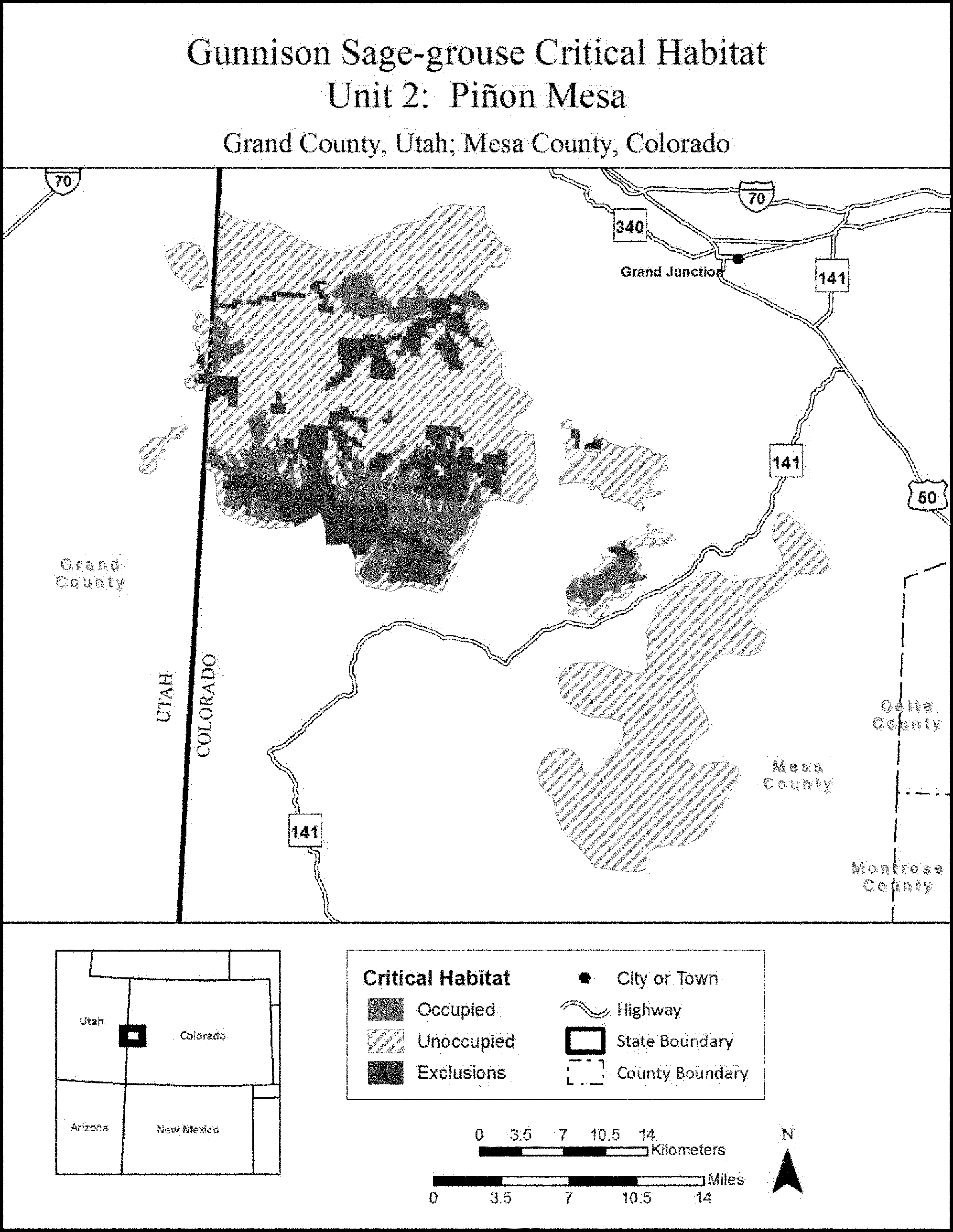
(8) Unit 3: San Miguel Basin: Montrose, San Miguel, and Ouray Counties, Colorado.
(i) General Description: 121,929 ac (49,343 ha); 8.5 percent of all critical habitat.
(ii) Map of Unit 3, San Miguel Basin: Montrose, San Miguel, and Ouray Counties, Colorado, follows:
Start Printed Page 69360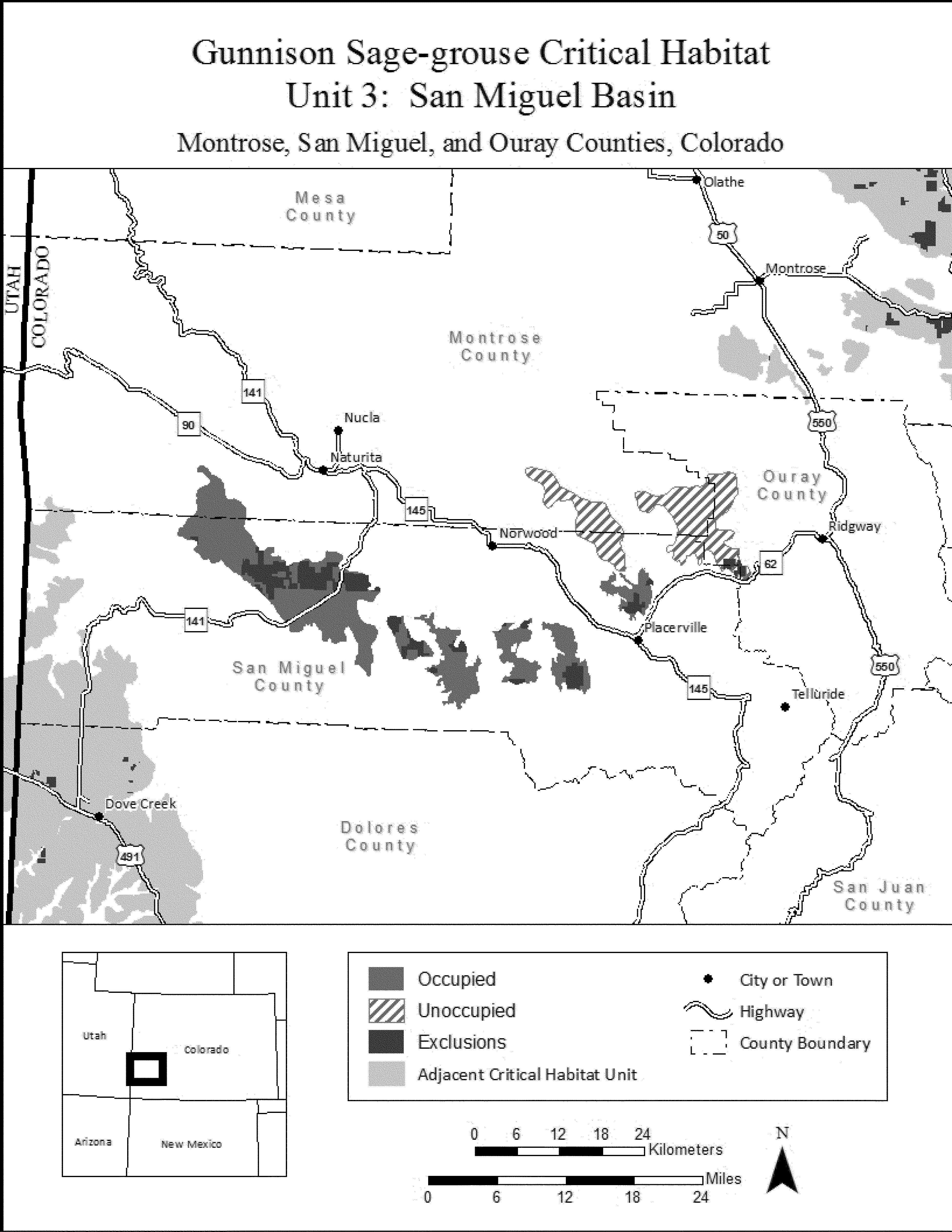
(9) Unit 4: Cerro Summit-Cimarron-Sims Mesa: Montrose, Ouray, and Gunnison Counties, Colorado.
(i) General Description: 52,544 ac (21,264 ha); 3.7 percent of all critical habitat.
(ii) Map of Unit 4, Cerro Summit-Cimarron-Sims Mesa: Montrose, Ouray, and Gunnison Counties, Colorado, follows:
Start Printed Page 69361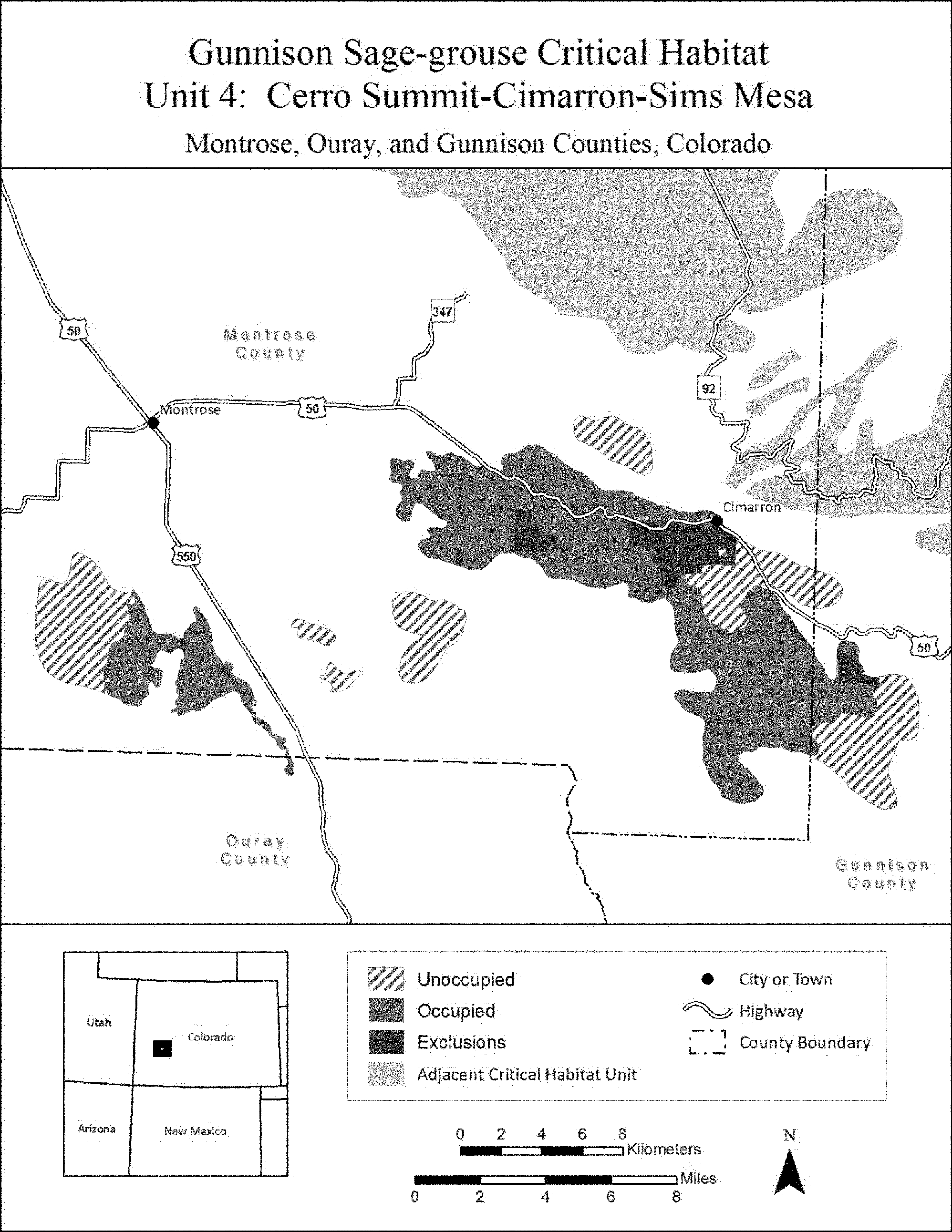
(10) Unit 5: Crawford: Delta, Montrose, and Gunnison Counties, Colorado.
(i) General Description: 83,671 ac (33,860 ha); 5.9 percent of all critical habitat.
(ii) Map of Unit 5, Crawford: Delta, Montrose, and Gunnison Counties, Colorado, follows:
Start Printed Page 69362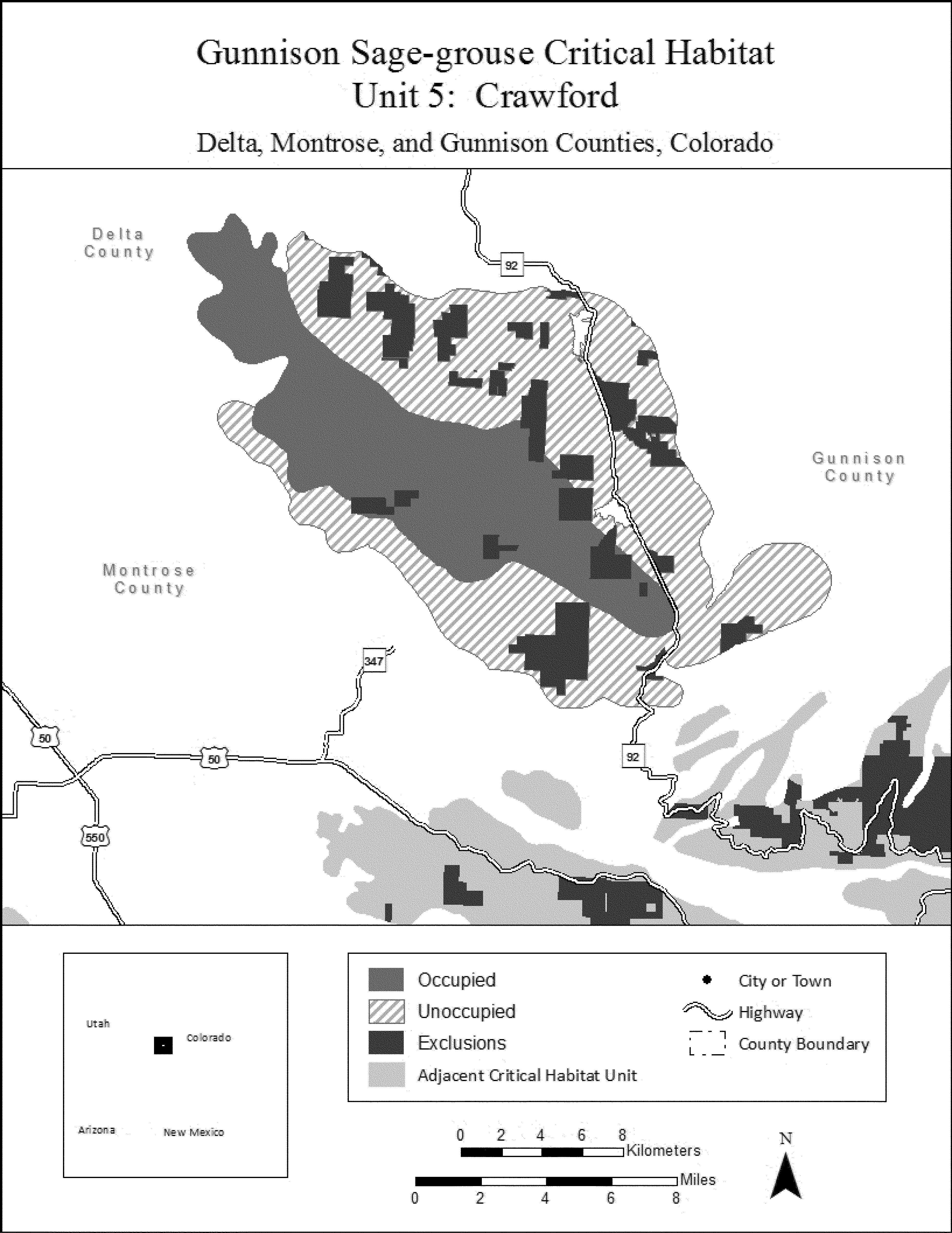
(11) Unit 6: Gunnison Basin: Gunnison, Saguache, Montrose, and Hinsdale Counties, Colorado.
(i) General Description: 620,616 ac (251,154 ha); 43.4 percent of all critical habitat.
(ii) Map of Unit 6, Gunnison Basin: Gunnison, Saguache, Montrose, and Hinsdale Counties, Colorado, follows:
Start Printed Page 69363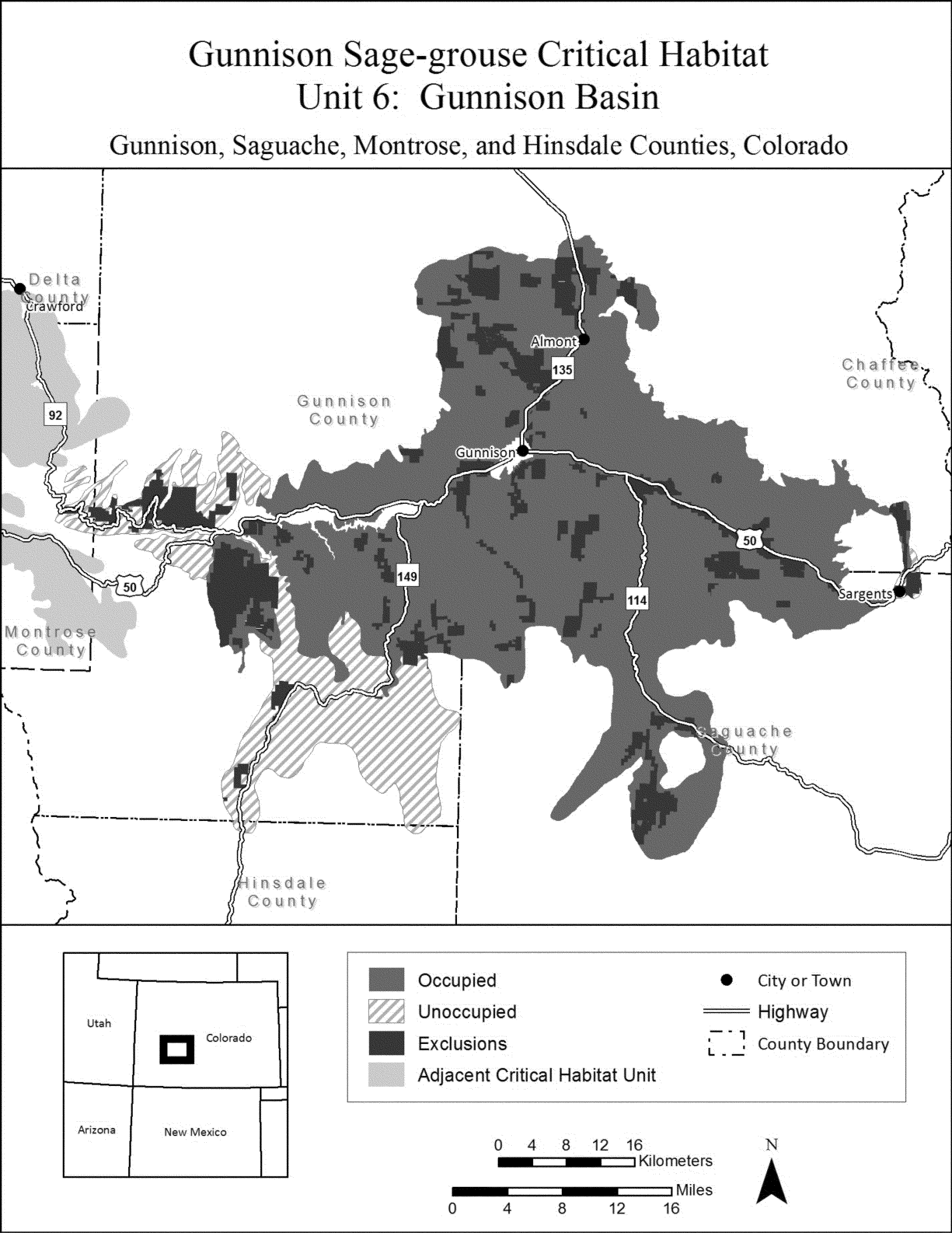 * * * * *End Signature End Supplemental Information
Dated: October 21, 2014.
Michael J. Bean,
Principal Deputy Assistant Secretary for Fish and Wildlife and Parks.


Document Information
- Effective Date:
- 12/22/2014
- Published:
- 11/20/2014
- Department:
- Fish and Wildlife Service
- Entry Type:
- Rule
- Action:
- Final rule.
- Document Number:
- 2014-27113
- Dates:
- This rule becomes effective on December 22, 2014.
- Pages:
- 69311-69363 (53 pages)
- Docket Numbers:
- Docket No. FWS-R6-ES-2011-0111, 4500030114
- RINs:
- 1018-AX71: Endangered and Threatened Wildlife and Plants; Designation of Critical Habitat for Gunnison Sage-Grouse
- RIN Links:
- https://www.federalregister.gov/regulations/1018-AX71/endangered-and-threatened-wildlife-and-plants-designation-of-critical-habitat-for-gunnison-sage-grou
- Topics:
- Endangered and threatened species, Exports, Imports, Reporting and recordkeeping requirements, Transportation
- PDF File:
- 2014-27113.pdf
- Supporting Documents:
- » Literature Cited GUSG Final Rule and CH 11_12_2014
- » Finding of No Significant Impact - Designation of Critical Habitat Gunnison Sage-grouse
- » Final Economic Analysis of Critical Habitat for the Gunnison Sage-grouse
- » Final Critical Habitat Designation Unit Coordinates Gunnison Sage-grouse
- » Environmental Assessment Designation of Critical Habitat for the Gunnison Sage-grouse
- » Draft Environmental Assessment for the Proposed Designation of Critical Habitat for Gunnison Sage-Grouse
- » Draft Economic Analysis of Critical Habitat Designation for the Gunnison Sage-Grouse
- » Related Docket: Endangered Status Listing for Gunnison Sage-Grouse - FWS-R6-ES-2012-0108
- » UTM Coordinates for Designation of Critical Habitat for the Gunnison Sage-grouse
- » Literature Cited for Gunnison Sage-grouse
- CFR: (1)
- 50 CFR 17.95