2017-02268. Magnuson-Stevens Act Provisions; Fisheries Off West Coast States; Pacific Coast Groundfish Fishery; 2017-2018 Biennial Specifications and Management Measures; Amendment 27
-
Start Preamble
Start Printed Page 9634
AGENCY:
National Marine Fisheries Service (NMFS), National Oceanic and Atmospheric Administration (NOAA), Commerce.
ACTION:
Final rule.
SUMMARY:
This final rule establishes the 2017-2018 harvest specifications and management measures for groundfish taken in the U.S. exclusive economic zone off the coasts of Washington, Oregon, and California, consistent with the Magnuson-Stevens Fishery Conservation and Management Act (MSA) and the Pacific Coast Groundfish Fishery Management Plan (PCGFMP), including harvest specifications consistent with default harvest control rules in the PCGFMP. This action also includes regulations to implement Amendment 27 to the PCGFMP, which adds deacon rockfish to the PCGFMP, reclassifies big skate as an actively managed stock, adds a new inseason management process for commercial and recreational groundfish fisheries in California, and makes several clarifications to existing regulations.
DATES:
This final rule is effective February 7, 2017.
ADDRESSES:
Information relevant to this final rule and Amendment 27, which includes an Environmental Assessment (EA), the Finding of No Significant Impact (FONSI), a regulatory impact review (RIR), final regulatory flexibility analysis (FRFA), and amended PCGFMP, are available from Barry A. Thom, Regional Administrator, West Coast Region, NMFS, 7600 Sand Point Way NE., Seattle, WA 98115-0070. Electronic copies of this final rule are also available at the NMFS West Coast Region Web site: http://www.westcoast.fisheries.noaa.gov.
Start Further InfoFOR FURTHER INFORMATION CONTACT:
Gretchen Hanshew, phone: 206-526-6147, fax: 206-526-6736, or email: Gretchen.hanshew@noaa.gov.
End Further Info End Preamble Start Supplemental InformationSUPPLEMENTARY INFORMATION:
Electronic Access
This rule is accessible via the Internet at the Office of the Federal Register Web site at http://www.access.gpo.gov/su_docs/aces/aces140.html. Background information and documents are available at the NMFS West Coast Region Web site at http://www.westcoast.fisheries.noaa.gov/fisheries/groundfish/index.html and at the Pacific Fishery Management Council's Web site at http://www.pcouncil.org.
Executive Summary
Purpose of the Regulatory Action
This final rule implements the 2017-2018 harvest specifications and management measures for groundfish species taken in the U.S. exclusive economic zone off the coasts of Washington, Oregon, and California, the harvest specifications consistent with default harvest control rules, and Amendment 27 to the PCGFMP. The purpose of this action is to conserve and manage Pacific Coast groundfish fishery resources to prevent overfishing, to rebuild overfished stocks, to ensure conservation, to facilitate long-term protection of essential fish habitats (EFH), and to realize the full potential of the Nation's fishery resources. This action includes harvest specifications for 2017-2018 consistent with existing or revised default harvest control rules for all stocks, and establishes management measures designed to keep catch within the appropriate limits. The harvest specifications are set consistent with the optimum yield (OY) harvest management framework described in Chapter 4 of the PCGFMP. This final rule also implements Amendment 27 to the PCGFMP. Amendment 27 adds deacon rockfish to the PCGFMP, reclassifies big skate as “in the fishery,” adds a new inseason management process for California fisheries, and makes several clarifications. This rule is authorized by 16 U.S.C. 1854 and 1855 and by the PCGFMP.
Major Provisions
This final rule contains two types of major provisions. The first are the harvest specifications (overfishing limits (OFLs), acceptable biological catches (ABCs), and annual catch limits (ACLs)), and the second are management measures designed to keep fishing mortality within the ACLs. The harvest specifications (OFLs, ABCs, and ACLs) in this rule have been developed through a rigorous scientific review and decision making process, which is described in detail in the proposed rule for this action (81 FR 75266, October 28, 2016) and is not repeated here.
This final rule includes ACLs for the five overfished species managed under the PCGFMP. For the 2017-2018 biennium darkblotched rockfish and Pacific ocean perch (POP) have rebuilding plan changes to their harvest control rules, while maintaining the current target year for rebuilding (TTARGET). The remaining overfished species are making adequate progress towards rebuilding. Therefore, this rule establishes harvest specifications consistent with the existing rebuilding plan provisions for those species.
This rule also implements Amendment 27 to the PCGFMP. Amendment 27 consists of five components that: (1) Reclassify big skate from an ecosystem component species to “in the fishery,” (2) add deacon rockfish to the list of species in the PCGFMP, (3) establish a new inseason management process in California for black, canary, and yelloweye rockfishes, (4) make updates to clarify several stock assessment descriptions, and (5) update several sections of the PCGFMP because canary rockfish and petrale sole are rebuilt. The Notice of Availability (NOA) for Amendment 27 to the PCGFMP (Amendment 27) published on September 30, 2016 (81 FR 67287) and the public comment period closed on November 29, 2016. Public comments received on the Amendment 27 are discussed below in “Comments and Reponses.”
In addition to the annual specifications, this final rule implements the same management measures that were described in the proposed rule, with a few modifications that are discussed below in “Changes from the Proposed Rule.” This final rule also corrects a computational error to the sablefish ACLs and revises sablefish trip limits, per the Council's recommendations made at its November 2016 meeting (See “Comments and Responses” and “Changes From the Proposed Rule,” below).
Comments and Responses
During the comment period of the proposed rule and NOA for Amendment 27, NMFS received one comment letter from the public in support of the proposed regulation changes to preserve fish populations and better regulate the fisheries in Washington, Oregon, and California. NMFS also received a letter from Department of the Interior stating they had reviewed the proposed rule and had no comments to offer. NMFS addresses other comments below.
Comment 1: A participant in the fishing industry made a general request Start Printed Page 9635for less restrictive management such that more fishing jobs would be available.
Response: Harvest specifications and management measures for Pacific Coast groundfish continue to be centered around allowing harvest of available target species such as sablefish, flatfish, Pacific whiting, etc., and keeping harvest of co-occurring overfished rockfish within their rebuilding plan ACLs. Every two years, through the biennial harvest specifications and management measures that this final rule implements, and in other ongoing rulemaking activities, the Council and NMFS work with industry and the public to develop and make incremental improvements to the management regime, including regulatory opportunities to increase efficiency and revenue. We note that some of the primary factors that drive revenue and jobs in the fishing industry include markets and price per pound, neither of which is within the direct control of the Council and NMFS. The harvest specifications and management measures implement regulations based on the best available scientific information and were developed through a public, collaborative Council process that incorporated feedback from affected industry and fishing communities.
Comment 2: The Council submitted a letter to NMFS on November 23, 2016, regarding the proposed sablefish ACLs for 2017-2018. In early November, stock assessment authors discovered an error in the calculation of the Council-recommended sablefish ACLs for 2017 and 2018 and notified Council and NMFS staff. At its November 13-21, 2016, meeting, under the inseason agenda item, the Council considered corrected ACLs and management measures and heard public testimony from industry in support of correcting the proposed ACLs and the resulting allocations. The Council recommended that these corrections be made by NMFS as quickly as possible.
Response: NMFS agrees that it is appropriate to correct the 2017-2018 sablefish ACLs and resulting allocations in this final rule. The FMP specifies long-term, formal sector allocations for north and south of 36° N. lat.; however the 2015 update stock assessment failed to correctly apportion the stock according to the 36° N. lat. Split, and instead used 34° 27′ N. lat. Consequently, the ACL amounts apportioned north and south in the proposed rule were incorrect and inconsistent with the FMP and past practice.
Corrected ACLs are included in Tables 1a and 2a, Subpart C. The Council's sablefish allocation framework and policies described in the proposed rule were applied to the updated ACLs, resulting in corrected allocations, as described below in “Changes From the Proposed Rule.”
Comment 3: In its November 23, 2016, letter, the Council also recommended adjustments to 2017-2018 routine management measures relative to limited entry fixed gear and open access sablefish trip limits. The adjustments to trip limits are based on the corrected sablefish ACLs and subsequent allocations, and also take into account the most recent fishery information. The Council recommended that these adjustments to trip limits be implemented on January 1, 2017, or as soon as possible thereafter.
Reponse: The Council's recommended trip limits are based on the best available information, and on the corrected sablefish ACLs and subsequent allocations. NMFS agrees that these trip limits should be implemented congruently with the corrected harvest specifications and allocations. However, lower trip limits, as recommended by the Council at its November 2016 meeting, may only be implemented at the beginning of Period 1 (January-February). This is because, once fishing in Period 1 has begun under higher trip limits, it is not enforceable to lower those trip limits until the start of the next cumulative limit period, or Period 2 (March-April). Therefore, for limited entry fixed gear north of 36° N. lat., NMFS is implementing the Council-recommended trip limits beginning on March 1, 2017 (at the start of Period 2). The Council has an opportunity, if necessary, to recommend further refinements to sablefish trip limits under routine inseason action at each Council meeting starting in March 2017. Revised trip limits for sablefish, as recommended by the Council at its November 2016 meeting, can be found in Tables 2 (North) and 2 (South), Supbart E, and Tables 3 (North) and 3 (South), Subpart F.
Changes From the Proposed Rule
Sablefish ACLs and Management Measures
As described above in Comments and Responses, sablefish ACLs were based on an incorrect north/south apportionment, resulting in incorrect proposed ACLs. For the reasons described above, the 2017-2018 sablefish ACLs and management measures for the areas north and south of 36° N. lat. are revised in this final rule to be consistent with the FMP and related analyses, including past EIS and RIR documents.
Regulatory citation/paragraph Description of the change § 660.50(f)(2)(ii) Corrected the 2017 and 2018 sablefish allocations for tribal fisheries. Tables 1a, 1b, 2a, and 2b to Supbart C Corrected the 2017 and 2018 sablefish ACLs, allocations, and harvest guidelines described there, including footnotes. Tables 1c and 2c to Subpart C Corrected 2017 and 2018 sablefish ACLs and allocations based on the long-term formal allocation structure described in the FMP for the area north of 36° N. lat. § 660.140(d)(1)(ii)(D) Corrected the 2017 and 2018 shorebased trawl allocations for sablefish north and south of 36° N. lat. § 660.231(b)(3)(i) Corrected the 2017 and 2018 sablefish tier limits for the sablefish primary fishery. Tables 2 (North) and 2 (South) to Supbart E and Tables 3 (North) and 3 (South) to Subpart F Revises sablefish trip limits consistent with corrected harvest targets. Trip Limit Reductions for Minor Nearshore Rockfish
The proposed rule included a reduction in trip limits for 2017-2018 for the Minor Nearshore Rockfish complex and black rockfish between 42° N. lat. and 40°10′ N. lat. for both limited entry fixed gear and open access fisheries. This reduced trip limit is to keep harvest of Minor Nearshore Rockfish and co-occurring species within their harvest targets and ACLs. In the October 23, 2016, proposed rule, consistent with the Council's recommendation, NMFS proposed to reduce the trip limit for this complex in both the limited entry fixed gear and open access fisheries from “8,500 lb per 2 months, no more than 1,200 lb of which may be species other than black rockfish” (the trip limit currently in Start Printed Page 9636regulation, and that would remain in regulation if no action was taken to superceed it) to “7,000 lb per 2 months, no more than 1,200 lb of which may be species other than black rockfish.” As described above in “Comments and Responses,” cumulative limits may only be lowered at the beginning of the 2-month period. Therefore, this final rule implements the proposed trip limit of 7,000 lb per 2 months beginning March 1.
Classification
Pursuant to section 304(b)(1)(A) of the Magnuson-Stevens Act (16 U.S.C. 1854(b)(1)(A)), the Administrator, West Coast Region, has determined that this final rule and Amendment 27 to the PCGFMP are necessary for the conservation and management of the Pacific Coast Groundfish Fishery and consistent with the Pacific Coast Groundfish Fishery Management Plan, other provisions of the Magnuson-Stevens Act, and other applicable law.
NMFS finds good cause to waive the 30-day delay in effectiveness pursuant to 5 U.S.C. 553(d)(3), so that this final rule may become effective upon publication in the Federal Register. Because this final rule increases the catch limits for several species for 2017, leaving 2016 harvest specifications in place could unnecessarily delay fishing opportunities until later in the year, potentially reducing the total catch for these species in 2017. Thus, a delay in effectiveness could ultimately cause economic harm to the fishing industry and associated fishing communities or result in harvest levels inconsistent with the best available scientific information. For example, due to the rebuilt status of canary rockfish, the Council recommended a modest trip limit to allow retention of this species for the first time in many years. This measure provides for a year round opportunity to turn regulatory discards into retained catch, while maintaining a precautionary trip limit to keep targeting effort on canary rockfish low. Because of the potential harm to fishing communities that could be caused by delaying the effectiveness of this final rule, NMFS finds there is good cause to waive the 30-day delay in effectiveness.
In addition, pursuant to 5 U.S.C. 553(b)(B), there is good cause to waive prior notice and an opportunity for public comment on the corrections contained in this action, as notice and comment would be impracticable, unnecessary, or contrary to the public interest. At its November meeting, the Council recommended corrections to 2017 and 2018 sablefish harvest specifications and resulting management measures be implemented as quickly as possible. There was not sufficient time after that meeting to allow for prior notice and opportunity for public comment before implementing these corrections so that NMFS could manage these fisheries using the best available science in accordance with the FMP (Section 2.1) and applicable law (National Standard 2). The corrected ACLs and resulting management measures are based on the best available scientific information regarding the relative biomass of sablefish north and south of 36° N. lat. The corrections implemented in this final rule are consistent with the impacts analyses for the proposed action, because the coastwide harvestable surplus (the sum of the northern and southern ACLs) is unchanged from the proposed rule; only the area-specific apportionment was incorrect. Further, correcting the sablefish ACLs is consistent with provisions in the FMP (Section 5.5) to allow timely corrections to ACLs due to technical errors, and also with the long-term formal allocation structure for sablefish north of 36° N. lat., which is predicated on an ACL calculated based on the relative biomass for the area north of 36° N. lat. Delaying the corrected sablefish ACLs and resulting management measures would keep regulations in place that are not based on the best available scientific information. Such a delay would impair achievement of the FMP goals and objectives of managing for appropriate harvest levels while providing for year-round fishing and marketing opportunities. Accordingly, for the reasons stated above, NMFS finds good cause to waive prior notice and comment.
NMFS prepared an EA for this action and Amendment 27 that discusses the impact on the environment as a result of some of the components of this rule. The full suite of alternatives analyzed by the Council can be found on the Council's Web site at www.pcouncil.org. This EA does not contain all of the alternatives because an EIS was prepared for the 2015-2016 biennial harvest specifications and management measures. Copies of the EA and the EIS are available from NMFS (see ADDRESSES). This EIS examined the harvest specifications and management measures for 2015-2016, and included ten year projections for routinely adjusted harvest specifications and management measures. The ten year projections were produced to evaluate the impacts of the ongoing implementation of harvest specifications and management measures and to evaluate the impacts of the routine adjustments that are the main component of regulatory changes in each biennial cycle. Therefore, the EA for the 2017-2018 cycle tiers from the 2015-2016 EIS, and focuses on the harvest specifications and management measures where the impacts were not within the scope of the ten year projections in the 2015-2016 EIS.
When an agency proposes regulations, the Regulatory Flexibility Act (RFA) requires the agency to prepare and make available for public comment an Initial Regulatory Flexibility Analysis (IRFA) document that describes the impact on small businesses, non-profit enterprises, local governments, and other small entities. The IRFA is to aid the agency in considering all reasonable regulatory alternatives that would minimize the economic impact on affected small entities. After the public comment period, the agency prepares a Final Regulatory Flexibility Analysis (FRFA) that takes into consideration any new information and public comments. This FRFA incorporates the IRFA and a summary of the analyses completed to support the action.
The comment period on the proposed rule closed on November 28, 2016, and no comments were received on the IRFA or the economic impacts of this action. An IRFA was prepared and summarized in the Classification section of the preamble to the proposed rule. The description of this action, its purpose, and its legal basis are described in the preamble to the proposed rule and are not repeated here. The FRFA describes the impacts on small entities, which are defined in the IRFA for this action and not repeated here. Analytical requirements for the FRFA are described in Regulatory Flexibility Act, section 604(a)(1) through (5), and summarized below.
The FRFA must contain: (1) A succinct statement of the need for, and objectives of, the rule; (2) A summary of the significant issues raised by the public comments in response to the IRFA, a summary of the assessment of the agency of such issues, and a statement of any changes made in the proposed rule as a result of such comments; (3) A description and an estimate of the number of small entities to which the rule will apply, or an explanation of why no such estimate is available; (4) A description of the projected reporting, recordkeeping and other compliance requirements of the rule, including an estimate of the classes of small entities which will be subject to the requirement and the type of professional skills necessary for Start Printed Page 9637preparation of the report or record; and (5) A description of the steps the agency has taken to minimize the significant economic impact on small entities consistent with the stated objectives of applicable statutes, including a statement of the factual, policy, and legal reasons for selecting the alternative adopted in the final rule and why each one of the other significant alternatives to the rule considered by the agency which affect the impact on small entities was rejected.
This final rule will regulate businesses that participate in the groundfish fishery. This rule directly affects limited entry fixed gear permit holders, trawl quota share (QS) holders and Pacific whiting catch history endorsed permit holders (which include shorebased Pacific whiting processors), tribal vessels, charterboat vessels, and open access vessels. QS holders are directly affected as their QS are affected by the ACLs. Vessels that fish under the trawl rationalization program receive their quota pounds from the QS holders, and thus are indirectly affected. Similarly, mothership (MS) processors are indirectly affected as they receive the fish they process from limited entry permits that are endorsed with Pacific whiting catch history assignments.
To determine the number of small entities potentially affected by this rule, NMFS reviewed analyses of fish ticket data and limited entry permit data, information on charterboat, tribal, and open access fleets, available cost-earnings data developed by the Northwest Fisheries Science Center, and responses associated with the permitting process for the Trawl Rationalization Program where applicants were asked if they considered themselves a small business based on SBA definitions. This rule will regulate businesses that harvest groundfish.
Charter Operations
There were 355 active commercial passenger fishing vessels (charter) engaged in groundfish fishing in California in 2014. In 2014, an estimated 189 charter boats targeted groundfish in Oregon and Washington. All 544 of these vessels and associated small businesses are likely to be impacted by changes in recreational harvest levels for groundfish.
Commercial Vessels and Shorebased Buyers
With limited access to data for all the affiliated business operations for vessels and buyers, particularly in the open access and fixed gear fisheries, NMFS estimates the type of impacted vessels and buyer entities based solely on West Coast ex-vessel revenue. This may be an underestimate of the number of large-entities in the fishery, as many vessels and buyers may be affiliated, and may have income from non-West Coast sources (particularly Alaska).
Open access vessels are not federally permitted so counts based on landings can provide an estimate of the affected vessels. The analysis for the 2013-2014 Pacific Groundfish Harvest Specifications and Management Measures Environmental Impact Statement contained the following assessment, which is deemed as containing reasonable estimates for this rule, as these fisheries have not changed significantly in recent years. In 2011, 682 directed open access vessels fished while 284 incidental open access vessels fished for a total of 966 vessels. Over the 2005-2010 period, 1,583 different directed open access vessels fished, and 837 different incidental open access vessels fished, for a total of 2,420 different vessels. The four tribal fleets sum to a total of 54 longline vessels, 5 Pacific whiting trawlers, and 5 non-whiting trawlers, for an overall total of 64 vessels. Available information on average revenue per vessel suggests that all the entities in these groups can be considered small.
It is expected that a total of 873 catcher vessels (CVs), 227 buyers, 9 Catcher/Processors (C/Ps) and 6 MS entities will be impacted by this rule, for a total of 1,115, if commercial groundfish participation in 2017-2018 follows similar patterns to those of the last full year of available data (2015), and counting only those vessels and buyers who had at least $1,000 worth of groundfish sales or purchases in 2015.
Groundfish Ex-Vessel Revenues by Fishery
N West Coast total groundfish revenue Average groundfish revenue LE Trawl C/P 9 $99,180,000 (2014 wholesale) $11,020,000 (2014 wholesale). MS 5 $46,385,000 (2014 wholesale) $9,277,000 (2014 wholesale). CV 83 $30,832,277 (2015 ex-vessel) $371,473 (2015 ex-vessel). MS/CV 19 $17,300,000 (2014 ex-vessel) $910,536.31 (2014 ex-vessel). Buyers 16 $137,600,000 (2014 wholesale) $8,600,000 (2014 wholesale). LE Fixed Gear Primary 89 $8,357,122 (2015 ex-vessel) $93,900 (2015 ex-vessel). DTL 152 $16,623,889 (2015 ex-vessel) $109,368 (2015 ex-vessel). Buyers 108 N/A N/A. OA CV 831 $7,281,894 (2015 ex-vessel) $8,763 (2015 ex-vessel). Buyers 307 N/A N/A. Research CV 4 $174,394 (2015 ex-vessel) $43,599 (2015 ex-vessel). Tribal CV 198 $4,933,911 (2015 ex-vessel) $24,918 (2015 ex-vessel). Buyers 19 N/A N/A. Note: 2015 reported revenues obtained from the Pacific Fisheries Information Network (PacFIN); 2014 reported revenues obtained from 2016 Economic Data Collection Reports. During development of the 2017-2018 harvest specifications, a mistake was made in apportioning the sablefish ACLs north and south of 36° N. lat. While the coastwide values used for calculating revenues in the IRFA were correctly calculated, the area-specific ACLs in the proposed rule were incorrect. The proposed ACLs were based on a north/south dividing line of 34′27° N. lat. rather than the actual north/south dividing line of 36° N. lat. Correcting the percentages for apportioning the ACLs, results in area-specific ACLs that best represent the relative biomass for the areas in which those ACLs apply. The corrected ACLs and allocations are consistent with the FMP and will be corrected in this final rule, and thus is not expected to impact small entities. Coastwide sablefish harvest levels, which were correctly calculated in the proposed rule and analyzed under the IRFA, are not revised.Start Printed Page 9638
Limited Entry Permit Owners
As part of the permitting process for the trawl rationalization program or for participating in nontrawl limited entry permit fisheries, applicants were asked if they considered themselves a small business. NMFS reviewed the ownership and affiliation relationships of QS permit holders, vessel account holders, catcher processor permits, MS processors, and first receiver/shore processor permits. As of August 1, 2016, Dock Street Brokers has West Coast limited entry trawl endorsed permits for sale for $60,000 for a 46.1′ permit, and two 43′ West Coast longline permits for $135,000-$140,000. QS may be valued anywhere from tens of thousands to millions of dollars, depending on the species and amount owned, although not enough sales have occurred yet to be able to confidently estimate their value.
Limited Entry Permit-Owner Entities by Small Business Self-Designation
Permit type Small business designation Total Small Large LE Trawl C/P 0 10 10 MS 4 2 6 CV 142 21 163 FR 36 8 44 QS N/A N/A 173 LE Fixed Gear Primary 159 3 162 DTL 52 8 60 If permit ownership in 2017-2018 follows similar patterns to those of the last full year available data (2015), it is expected that a total of 312 permit owning entities will be impacted by this rule. An estimated 222 of these entities own both permits and vessels, and 16 of the first receiver permit holding companies actually received groundfish, and are thus included in the table above.
Accounting for joint vessel and permit ownership in the limited entry fisheries to the extent possible, an estimated 1,189 commercial entities and 544 charter entities will be impacted by this rule; 16 of these entities are considered large, and the remaining 1,717 are small. As some of these entities are likely owned by the same parent companies, this number is likely an overestimate of the true value.
There are no reporting and recordkeeping requirements associated with this action. There are no significant alternatives to the final rule that accomplish the stated objectives of applicable statutes and that minimize any of the significant economic impact of this final rule on small entities.
Considered But Rejected Measures
A summary of the three measures that were analyzed but were excluded from the preferred alternative, and rationales for excluding them from the preferred alternative, were described in the proposed rule and are not repeated here.
Pursuant to Executive Order 13175, this final rule was developed after meaningful consultation and collaboration with tribal officials from the area covered by the PCGFMP. Under the Magnuson-Stevens Act at 16 U.S.C. 1852(b)(5), one of the voting members of the Pacific Council must be a representative of an Indian tribe with federally recognized fishing rights from the area of the Council's jurisdiction. In addition, regulations implementing the PCGFMP establish a procedure by which the tribes, which have treaty fishing rights in the area covered by the PCGFMP, request new allocations or regulations specific to the tribes, in writing, before the first of the two meetings at which the Council considers groundfish management measures. The regulations at 50 CFR 660.324(d) further state that the Secretary will develop tribal allocations and regulations in consultation with the affected tribe(s) and, insofar as possible, with tribal consensus. The tribal management measures in this final rule have been developed following these procedures. The tribal representative on the Council made a motion to adopt the non-whiting tribal management measures, which was passed by the Council. Those management measures, which were developed and proposed by the tribes, were described in the proposed rule and are included in this final rule.
This final rule has been determined to be not significant for purposes of Executive Order 12866.
Start List of SubjectsList of Subjects in 50 CFR Part 660
- Fisheries
- Fishing
- Reporting and recordkeeping requirements
End SignatureDated: January 30, 2017.
Alan D. Risenhoover,
Acting Deputy Assistant Administrator for Regulatory Programs, National Marine Fisheries Service.
For the reasons set out in the preamble, 50 CFR part 660 is amended as follows:
Start PartPART 660--FISHERIES OFF WEST COAST STATES
End Part Start Amendment Part1. The authority citation for part 660 continues to read as follows:
End Amendment Part Start Amendment Part2. In § 660.11 in the definition of “Groundfish,” paragraphs (7)(i)(A) and (7)(i)(B)( 2) are revised to read as follows:
End Amendment PartStart Amendment PartGeneral definitions.* * * * *(7) * * *
(i) * * *
(A) North of 40°10′ N. lat.: Black and yellow rockfish, S. chrysomelas; blue rockfish, S. mystinus; brown rockfish, S. auriculatus; calico rockfish, S. dalli; China rockfish, S. nebulosus; copper rockfish, S. caurinus; deacon rockfish, S. diaconus, gopher rockfish, S. carnatus; grass rockfish, S. rastrelliger; kelp rockfish, S. atrovirens; olive rockfish, S. serranoides; quillback rockfish, S. maliger; treefish, S. serriceps.
(B) * * *
(2) Deeper nearshore rockfish consists of black rockfish, S. melanops; blue rockfish, S. mystinus; brown rockfish, S. auriculatus; calico rockfish, S. dalli; copper rockfish, S. caurinus; deacon rockfish, S. diaconus; olive rockfish, S. serranoides; quillback rockfish, S. maliger; treefish, S. serriceps.
* * * * *3. Section 660.40 is revised to read as follows:
End Amendment PartStart Amendment PartOverfished species rebuilding plans.For each overfished groundfish stock with an approved rebuilding plan, this section contains the standards to be used to establish annual or biennial Start Printed Page 9639ACLs, specifically the target date for rebuilding the stock to its MSY level and the harvest control rule to be used to rebuild the stock. The harvest control rule may be expressed as a “Spawning Potential Ratio” or “SPR” harvest rate.
(a) Bocaccio. Bocaccio south of 40°10′ N. latitude was declared overfished in 1999. The target year for rebuilding the bocaccio stock south of 40°10′ N. latitude to BMSY is 2022. The harvest control rule to be used to rebuild the southern bocaccio stock is an annual SPR harvest rate of 77.7 percent.
(b) Cowcod. Cowcod was declared overfished in 2000. The target year for rebuilding the cowcod stock south of 40°10′ N. lat. to BMSY is 2020. The harvest control rule to be used to rebuild the cowcod stock is an annual SPR harvest rate of 82.7 percent.
(c) Darkblotched rockfish. Darkblotched rockfish was declared overfished in 2000. The target year for rebuilding the darkblotched rockfish stock to BMSY is 2025. The harvest control rule is ACL = ABC (P* = 0.45).
(d) Pacific ocean perch (POP). POP was declared overfished in 1999. The target year for rebuilding the POP stock to BMSY is 2051. The harvest control rule to be used to rebuild the POP stock in 2017 and 2018 is a constant catch ACL of 281 mt per year. In 2019 and thereafter the harvest control rule to be used to rebuild POP is an annual SPR harvest rate of 86.4 percent.
(e) Yelloweye rockfish. Yelloweye rockfish was declared overfished in 2002. The target year for rebuilding the yelloweye rockfish stock to BMSY is 2074. The harvest control rule to be used to rebuild the yelloweye rockfish stock is an annual SPR harvest rate of 76.0 percent.
4. In § 660.50, revise paragraphs (f)(2)(ii) and (f)(3), add paragraph (f)(9), and revise paragraph (g) to read as follows:
End Amendment PartStart Amendment PartPacific Coast treaty Indian fisheries.* * * * *(f) * * *
(2) * * *
(ii) The Tribal allocation is 525 mt in 2017 and 548 mt in 2018 per year. This allocation is, for each year, 10 percent of the Monterey through Vancouver area (North of 36° N. lat.) ACL. The Tribal allocation is reduced by 1.5 percent for estimated discard mortality.
(3) Lingcod. Lingcod taken in the treaty fisheries are subject to a harvest guideline of 250 mt.
* * * * *(9) Widow rockfish. Widow rockfish taken in the directed tribal midwater trawl fisheries are subject to a catch limit of 200 mt for the entire fleet, per year.
(g) Pacific Coast treaty Indian fisheries management measures. Trip limits for certain species were recommended by the tribes and the Council and are specified here.
(1) Rockfish. The tribes will require full retention of all overfished rockfish species and all other marketable rockfish species during treaty fisheries.
(2) Yelloweye rockfish—are subject to a 100-lb (45-kg) trip limit.
(3) Other rockfish—(i) Minor nearshore rockfish. Minor nearshore rockfish are subject to a 300-lb (136-kg) trip limit per species or species group, or to the non-tribal limited entry trip limit for those species if those limits are less restrictive than 300 lb (136 kg) per trip. Limited entry trip limits for waters off Washington are specified in Table 1 (North) to subpart D, and Table 2 (North) to subpart E of this part.
(ii) Minor shelf rockfish and minor slope rockfish. Redstripe rockfish are subject to an 800 lb (363 kg) trip limit. Minor shelf (excluding redstripe rockfish), and minor slope rockfish groups are subject to a 300 lb (136 kg) trip limit per species or species group, or to the non-tribal limited entry fixed gear trip limit for those species if those limits are less restrictive than 300 lb (136 kg) per trip. Limited entry fixed gear trip limits are specified in Table 2 (North) to subpart E of this part.
(iii) Other rockfish. All other rockfish, not listed specifically in paragraph (g) of this section, are subject to a 300 lb (136 kg) trip limit per species or species group, or to the non-tribal limited entry trip limit for those species if those limits are less restrictive than 300 lb (136 kg) per trip. Limited entry trip limits for waters off Washington are specified in Table 1 (North) to subpart D, and Table 2 (North) to subpart E of this part.
(4) Pacific whiting. Tribal whiting processed at-sea by non-tribal vessels, must be transferred within the tribal U&A from a member of a Pacific Coast treaty Indian tribe fishing under this section.
(5) Groundfish without a tribal allocation. Makah tribal members may use midwater trawl gear to take and retain groundfish for which there is no tribal allocation and will be subject to the trip landing and frequency and size limits applicable to the limited entry fishery.
(6) EFH. Measures implemented to minimize adverse impacts to groundfish EFH, as described in § 660.12 of this subpart, do not apply to tribal fisheries in their U&A fishing areas described at § 660.4, subpart A.
(7) Small footrope trawl gear. Makah tribal members fishing in the bottom trawl fishery may use only small footrope (less than or equal to 8 inches (20.3 cm)) bottom trawl gear.
5. In § 660.55, revise paragraph (b) introductory text to read as follows:
End Amendment PartStart Amendment PartAllocations.* * * * *(b) Fishery harvest guidelines and reductions made prior to fishery allocations. Prior to the setting of fishery allocations, the TAC, ACL, or ACT when specified, is reduced by the Pacific Coast treaty Indian Tribal harvest (allocations, set-asides, and estimated harvest under regulations at § 660.50); projected scientific research catch of all groundfish species, estimates of fishing mortality in non-groundfish fisheries; and, as necessary, deductions to account for unforeseen catch events and deductions for EFPs. Deductions are listed in the footnotes of Tables 1a and 2a of subpart C of this part. The remaining amount after these deductions is the fishery harvest guideline or quota. (Note: recreational estimates are not deducted here.)
* * * * *6. In § 660.60, paragraphs (c)(1)(i) and (c)(3)(ii) are revised and paragraph (c)(4) is added to read as follows:
End Amendment PartStart Amendment PartSpecifications and management measures.* * * * *(c) * * *
(1) * * *
(i) Trip landing and frequency limits, size limits, all gear. Trip landing and frequency limits have been designated as routine for the following species or species groups: Widow rockfish, canary rockfish, yellowtail rockfish, Pacific ocean perch, yelloweye rockfish, black rockfish, blue/deacon rockfish, splitnose rockfish, blackgill rockfish in the area south of 40°10′ N. lat., chilipepper, bocaccio, cowcod, Minor Nearshore Rockfish or shallow and deeper Minor Nearshore Rockfish, shelf or Minor Shelf Rockfish, and Minor Slope Rockfish; Dover sole, sablefish, shortspine thornyheads, and longspine thornyheads; petrale sole, rex sole, arrowtooth flounder, Pacific sanddabs, big skate, and the Other Flatfish complex, which is composed of those species plus any other flatfish species listed at § 660.11; Pacific whiting; lingcod; Pacific cod; spiny dogfish; longnose skate; cabezon in Oregon and California and “Other Fish” as defined at § 660.11. In addition to the species and species groups listed above, sub-limits or aggregate limits may be specified, specific to the Shorebased Start Printed Page 9640IFQ Program, for the following species: Big skate, California skate, California scorpionfish, leopard shark, soupfin shark, finescale codling, Pacific rattail (grenadier), ratfish, kelp greenling, shortbelly rockfish, and cabezon in Washington. Size limits have been designated as routine for sablefish and lingcod. Trip landing and frequency limits and size limits for species with those limits designated as routine may be imposed or adjusted on a biennial or more frequent basis for the purpose of keeping landings within the harvest levels announced by NMFS, and for the other purposes given in paragraphs (c)(1)(i)(A) and (B) of this section.
* * * * *(3) * * *
(ii) Non-tribal deductions from the ACL. Changes to the non-tribal amounts deducted from the TAC, ACLs, or ACT when specified, described at § 660.55(b)(2) through (4) and specified in the footnotes to Tables 1a through 1c, and 2a through 2c, to subpart C, have been designated as routine to make fish that would otherwise go unharvested available to other fisheries during the fishing year. Adjustments may be made to provide additional harvest opportunities in groundfish fisheries when catch in scientific research activities, non-groundfish fisheries, and EFPs are lower than the amounts that were initially deducted off the TAC, ACL, or ACT when specified, during the biennial specifications or to allocate yield from the deduction to account for unforeseen catch events to groundfish fisheries. When recommending adjustments to the non-tribal deductions, the Council shall consider the allocation framework criteria outlined in the PCGFMP and the objectives to maintain or extend fishing and marketing opportunities taking into account the best available fishery information on sector needs.
(4) Inseason action for canary rockfish, yelloweye rockfish, and black rockfish in California State-Specific Federal Harvest Limits outside of a Council meeting. The Regional Administrator, NMFS West Coast Region, after consultation with the Chairman of the Pacific Fishery Management Council and the Fishery Director of the California Department of Fish and Wildlife, or their designees, is authorized to modify the following designated routine management measures for canary rockfish, yelloweye rockfish, and black rockfish off the coast of California. For black rockfish in commercial fisheries trip landing and frequency limits; and depth based management measures. For black, canary, and yelloweye rockfish in recreational fisheries bag limits; time/area closures; depth based management. Any modifications may be made only after NMFS has determined that a California state-specific federal harvest limit for canary rockfish, yelloweye rockfish, or black rockfish, is attained or projected to be attained prior to the first day of the next Council meeting. Any modifications may only be used to restrict catch of canary rockfish, yelloweye rockfish, or black rockfish off the coast of California.
* * * * *7. In § 660.70, paragraphs (g) through (p) are redesignated as (i) through (r), and new paragraphs (g) and (h) are added to read as follows:
End Amendment PartStart Amendment PartGroundfish conservation areas.* * * * *(g) Stonewall Bank Yelloweye Rockfish Conservation Area, Expansion 1. The Stonewall Bank Yelloweye Rockfish Conservation Area (YRCA) Expansion 1 is an area off central Oregon, near Stonewall Bank, intended to protect yelloweye rockfish. The Stonewall Bank YRCA Expansion 1 is defined by straight lines connecting the following specific latitude and longitude coordinates in the order listed:
(1) 44°41.76′ N. lat.; 124°30.02′ W. long.;
(2) 44°41.73′ N. lat.; 124°21.60′ W. long.;
(3) 44°25.25′ N. lat.; 124°16.94′ W. long.;
(4) 44°25.29′ N. lat.; 124°30.14′ W. long.;
(5) 44°41.76′ N. lat.; 124°30.02′ W. long.; and connecting back to 44°41.76′ N. lat.; 124°30.02′ W. long.
(h) Stonewall Bank Yelloweye Rockfish Conservation Area, Expansion 2. The Stonewall Bank Yelloweye Rockfish Conservation Area (YRCA) Expansion 2 is an area off central Oregon, near Stonewall Bank, intended to protect yelloweye rockfish. The Stonewall Bank YRCA Expansion 2 is defined by straight lines connecting the following specific latitude and longitude coordinates in the order listed:
(1) 44°38.54′ N. lat.; 124°27.41′ W. long.;
(2) 44°38.54′ N. lat.; 124°23.86′ W. long.;
(3) 44°27.13′ N. lat.; 124°21.50′ W. long.;
(4) 44°27.13′ N. lat.; 124°26.89′ W. long.;
(5) 44°31.30′ N. lat.; 124°28.35′ W. long.; and connecting back to 44°38.54′ N. lat.; 124°27.41′ W. long.
* * * * *8. Amend § 660.71 as follows:
End Amendment Part Start Amendment Parta. Redesignate paragraphs (e)(143) through (332) as paragraphs (e)(147) through (336), respectively and redesignate paragraphs (e)(140) through (142) as paragraphs (e)(141) through (143), respectively;
End Amendment Part Start Amendment Partb. Add new paragraphs (e)(140) and (e)(144) through (146);
End Amendment Part Start Amendment Partc. Revise newly redesignated paragraph (e)(168);
End Amendment Part Start Amendment Partd. Redesignate paragraphs (k)(128) through (214) as paragraphs (k)(130) through (216), respectively and redesignate paragraphs (k)(120) through (127) as paragraphs (k)(121) through (128), respectively;
End Amendment Part Start Amendment Parte. Add new paragraph (k)(120);
End Amendment Part Start Amendment Partf. Revise newly redesignated paragraph (k)(128);
End Amendment Part Start Amendment Partg. Add new paragraph (k)(129).
End Amendment PartThe revisions and additions read as follows:
Start Amendment PartLatitude/longitude coordinates defining the 10-fm (18-m) through 40-fm (73-m) depth contours.* * * * *(e) * * *
(140) 39°37.50′ N. lat., 123°49.20′ W. long.;
* * * * *(144) 39°13.00′ N. lat., 123°47.65′ W. long.;
(145) 39°11.06′ N. lat., 123°47.16′ W. long.;
(146) 39°10.35′ N. lat., 123°46.75′ W. long.;
* * * * *(168) 37°39.85.′ N. lat., 122°49.90′ W. long.;
* * * * *(k) * * *
(120) 38°30.57′ N. lat., 123°18.60′ W. long.;
* * * * *(128) 37°48.22′ N. lat., 123°10.62′ W. long.;
(129) 37°47.53′ N. lat., 123°11.54′ W. long.;
* * * * *9. In § 660.72, paragraph (a)(107) is revised to read as follows:
End Amendment PartStart Amendment PartLatitude/longitude coordinates defining the 50 fm (91 m) through 75 fm (137 m) depth contours.* * * * *(a) * * *
(107) 37°45.57′ N. lat., 123°9.46′ W. long.;
* * * * *10. In § 660.73, redesignate paragraphs (h)(248) through (h)(309) as (h)(252) through (h)(313) and add new paragraphs (h)(248) through (h)(251) to read as follows:
End Amendment PartStart Printed Page 9641Start Amendment PartLatitude/longitude coordinates defining the 100 fm (183 m) through 150 fm (274 m) depth contours.* * * * *(h) * * *
(248) 36°47.60′ N. lat., 121°58.88′ W. long.;
(249) 36°48.24′ N. lat., 121°51.40′ W. long.;
(250) 36°45.84′ N. lat., 121°57.21′ W. long.;
(251) 36°45.77′ N. lat., 121°57.61′ W. long.;
* * * * *11. Tables 1a through 1d to Part 660, Subpart C, are revised to read as follows:
End Amendment Part Start Printed Page 9642
Start Printed Page 9643
a Annual catch limits (ACLs), annual catch targets (ACTs) and harvest guidelines (HGs) are specified as total catch values.
b Fishery harvest guidelines means the harvest guideline or quota after subtracting Pacific Coast treaty Indian tribes allocations and projected catch, projected research catch, deductions for fishing mortality in non-groundfish fisheries, and deductions for EFPs from the ACL or ACT.
c Bocaccio. A stock assessment was conducted in 2015 for the bocaccio stock between the U.S.-Mexico border and Cape Blanco. The stock is managed with stock-specific harvest specifications south of 40°10′ N. lat. and within the Minor Shelf Rockfish complex north of 40°10′ N. lat. A historical catch distribution of approximately 7.4 percent was used to apportion the assessed stock to the area north of 40°10′ N. lat. The bocaccio stock was estimated to be at 36.8 percent of its unfished biomass in 2015. The OFL of 2,139 mt is projected in the 2015 stock assessment using an FMSY proxy of F50%. The ABC of 2,044 mt is a 4.4 percent reduction from the OFL (σ = 0.36 / P* = 0.45) because it is a category 1 stock. The 790 mt ACL is based on the current rebuilding plan with a target year to rebuild of 2022 and an SPR harvest rate of 77.7 percent. 15.4 mt is deducted from the ACL to accommodate the incidental open access fishery (0.8 mt), EFP catch (10 mt) and research catch (4.6 mt), resulting in a fishery HG of 774.6 mt. The California recreational fishery has an HG of 326.1 mt.
d Cowcod. A stock assessment for the Conception Area was conducted in 2013 and the stock was estimated to be at 33.9 percent of its unfished biomass in 2013. The Conception Area OFL of 58 mt is projected in the 2013 rebuilding analysis using an FMSY proxy of F50%. The OFL contribution of 12 mt for the unassessed portion of the stock in the Monterey area is based on depletion-based stock reduction analysis. The OFLs for the Monterey and Conception areas were summed to derive the south of 40°10′ N. lat. OFL of 70 mt. The ABC for the area south of 40°10′ N. lat. is 63 mt. The assessed portion of the stock in the Conception Area is considered category 2, with a Conception area contribution to the ABC of 53 mt, which is an 8.7 percent reduction from the Conception area OFL (σ = 0.72 / P* = 0.45). The unassessed portion of the stock in the Monterey area is considered a category 3 stock, with a contribution to the ABC of 10 mt, which is a 16.6 percent reduction from the Monterey area OFL (σ = 1.44 / P* = 0.45). A single ACL of 10 mt is being set for both areas combined. The ACL of 10 mt is based on the rebuilding plan with a target year to rebuild of 2020 and an SPR harvest rate of 82.7 percent, which is equivalent to an exploitation rate (catch over age 11+ biomass) of 0.007. 2 mt is deducted from the ACL to accommodate the incidental open access fishery (less than 0.1 mt), EFP fishing (less than 0.1 mt) and research activity (2 mt), resulting in a fishery HG of 8 mt. Any additional mortality in research activities will be deducted from the ACL. A single ACT of 4 mt is being set for both areas combined.
e Darkblotched rockfish. A 2015 stock assessment estimated the stock to be at 39 percent of its unfished biomass in 2015. The OFL of 671 mt is projected in the 2015 stock assessment using an FMSY proxy of F50%. The ABC of 641 mt is a 4.4 percent reduction from the OFL (σ = 0.36 / P* = 0.45) because it is a category 1 stock. The ACL is set equal to the ABC, as the stock is projected to be above its target biomass of B40% in 2017. 77.3 mt is deducted from the ACL to accommodate the Tribal fishery (0.2 mt), the incidental open access fishery (24.5 mt), EFP catch (0.1 mt), research catch (2.5 mt) and an additional deduction for unforeseen catch events (50 mt), resulting in a fishery HG of 563.8 mt.
f Pacific ocean perch. A stock assessment was conducted in 2011 and the stock was estimated to be at 19.1 percent of its unfished biomass in 2011. The OFL of 964 mt for the area north of 40°10′ N. lat. is based on an updated catch-only projection of the 2011 rebuilding analysis using an F50% FMSY proxy. The ABC of 922 mt is a 4.4 percent reduction from the OFL (σ = 0.36 / P* = 0.45) because it is a category 1 stock. The ACL is based on the current rebuilding plan with a target year to rebuild of 2051 and a constant catch amount of 281 mt in 2017 and 2018, followed in 2019 and beyond by ACLs based on an SPR harvest rate of 86.4 percent. 49.4 mt is deducted from the ACL to accommodate the Tribal fishery (9.2 mt), the incidental open access fishery (10 mt), research catch (5.2 mt) and an additional deduction for unforeseen catch events (25 mt), resulting in a fishery HG of 231.6 mt.
g Yelloweye rockfish. A stock assessment update was conducted in 2011. The stock was estimated to be at 21.4 percent of its unfished biomass in 2011. The 57 mt coastwide OFL is based on a catch-only update of the 2011 stock assessment, assuming actual catches since 2011 and using an FMSY proxy of F50%. The ABC of 47 mt is a 16.7 percent reduction from the OFL (σ = 0.72 / P* = 0.40) because it is a category 2 stock. The 20 mt ACL is based on the current rebuilding plan with a target year to rebuild of 2074 and an SPR harvest rate of 76.0 percent. 5.4 mt is deducted from the ACL to accommodate the Tribal fishery (2.3 mt), the incidental open access fishery (0.4 mt), EFP catch (less than 0.1 mt) and research catch (2.7 mt), resulting in a fishery HG of 14.6 mt. Recreational HGs are: 3.3 mt (Washington); 3 mt (Oregon); and 3.9 mt (California).
h Arrowtooth flounder. The arrowtooth flounder stock was last assessed in 2007 and was estimated to be at 79 percent of its unfished biomass in 2007. The OFL of 16,571 mt is derived from a catch-only update of the 2007 stock assessment assuming actual catches since 2007 and using an F30% FMSY proxy. The ABC of 13,804 mt is a 16.7 percent reduction from the OFL (σ = 0.72 / P* = 0.40) because it is a category 2 stock. The ACL is set equal to the ABC because the stock is above its target biomass of B25%. 2,098.1 mt is deducted from the ACL to accommodate the Tribal fishery (2,041 mt), the incidental open access fishery (40.8 mt), and research catch (16.4 mt), resulting in a fishery HG of 11,705.9 mt.
i Big skate. The OFL of 541 mt is based on an estimate of trawl survey biomass and natural mortality. The ABC of 494 mt is an 8.7 percent reduction from the OFL (σ = 0.72 / P* = 0.45) as it is a category 2 stock. The ACL is set equal to the ABC. 57.4 mt is deducted from the ACL to accommodate the Tribal fishery (15 mt), the incidental open access fishery (38.4 mt), and research catch (4 mt), resulting in a fishery HG of 436.6 mt.
j Black rockfish (California). A 2015 stock assessment estimated the stock to be at 33 percent of its unfished biomass in 2015. The OFL of 349 mt is projected in the 2015 stock assessment using an FMSY proxy of F50%. The ABC of 334 mt is a 4.4 percent reduction from the OFL (σ = 0.36 / P* = 0.45) because it is a category 1 stock. The ACL is set equal to the ABC because the stock is projected to be above its target biomass of B40% in 2017. 1 mt is deducted from the ACL to accommodate EFP catch (1 mt), resulting in a fishery HG of 333 mt.
k Black rockfish (Oregon). A 2015 stock assessment estimated the stock to be at 60 percent of its unfished biomass in 2015. The OFL of 577 mt is projected in the 2015 stock assessment using an FMSY proxy of F50%. The ABC of 527 mt is an 8.7 percent reduction from the OFL (σ = 0.72 / P* = 0.45) because it is a category 2 stock. The ACL is set equal to the ABC because the stock is above its target biomass of B40%. 0.6 mt is deducted from the ACL to accommodate the incidental open access fishery (0.6 mt), resulting in a fishery HG of 526.4 mt.
l Black rockfish (Washington). A 2015 stock assessment estimated the stock to be at 43 percent of its unfished biomass in 2015. The OFL of 319 mt is projected in the 2015 stock assessment using an FMSY proxy of F50%. The ABC of 305 mt is a 4.4 percent reduction from the OFL (σ = 0.36 / P* = 0.45) because it is a category 1 stock. The ACL is set equal to the ABC because the stock is above its target biomass of B40%. 18 mt is deducted from the ACL to accommodate the Tribal fishery, resulting in a fishery HG of 287 mt.
m Blackgill rockfish. Blackgill rockfish contributes to the harvest specifications for the Minor Slope Rockfish South complex. See footnotepp.
n Cabezon (California). A cabezon stock assessment was conducted in 2009. The cabezon spawning biomass in waters off California was estimated to be at 48.3 percent of its unfished biomass in 2009. The OFL of 157 mt is calculated using an FMSY proxy of F45%. The ABC of 150 mt is based on a 4.4 percent reduction from the OFL (σ = 0.36 / P* = 0.45) because it is a category 1 stock. The ACL is set equal to the ABC because the stock is above its target biomass of B40%. 0.3 mt is deducted from the ACL to accommodate the incidental open access fishery, resulting in a fishery HG of 149.7 mt.
o Cabezon (Oregon). A cabezon stock assessment was conducted in 2009. The cabezon spawning biomass in waters off Oregon was estimated to be at 52 percent of its unfished biomass in 2009. The OFL of 49 mt is calculated using an FMSY proxy of F45%. The ABC of 47 mt is based on a 4.4 percent reduction from the OFL (σ = 0.36 / P* = 0.45) because it is a category 1 species. The ACL is set equal to the ABC because the stock is above its target biomass of B40%. There are no deductions from the ACL so the fishery HG is also equal to the ACL of 47 mt.Start Printed Page 9644
p California scorpionfish. A California scorpionfish assessment was conducted in 2005 and was estimated to be at 79.8 percent of its unfished biomass in 2005. The OFL of 289 mt is based on projections from a catch-only update of the 2005 assessment assuming actual catches since 2005 and using an FMSY harvest rate proxy of F50%. The ABC of 264 mt is an 8.7 percent reduction from the OFL (σ = 0.72 / P* = 0.45) because it is a category 2 stock. The ACL is set at a constant catch amount of 150 mt. 2.2 mt is deducted from the ACL to accommodate the incidental open access fishery (2 mt) and research catch (0.2 mt), resulting in a fishery HG of 147.8 mt. An ACT of 111 mt is established.
q Canary rockfish. A stock assessment was conducted in 2015 and the stock was estimated to be at 55.5 percent of its unfished biomass coastwide in 2015. The coastwide OFL of 1,793 mt is projected in the 2015 assessment using an FMSY harvest rate proxy of F50%. The ABC of 1,714 mt is a 4.4 percent reduction from the OFL (σ = 0.36 / P* = 0.45) because it is a category 1 stock. The ACL is set equal to the ABC because the stock is above its target biomass of B40%. 247 mt is deducted from the ACL to accommodate the Tribal fishery (50 mt), the incidental open access fishery (1.2 mt), EFP catch (1 mt), research catch (7.2 mt), and an additional deduction for unforeseen catch events (188 mt), resulting in a fishery HG of 1,466.6 mt. Recreational HGs are: 50 mt (Washington); 75 mt (Oregon); and 135 mt (California).
r Chilipepper. A coastwide update assessment of the chilipepper stock was conducted in 2015 and estimated to be at 64 percent of its unfished biomass in 2015. Chilipepper are managed with stock-specific harvest specifications south of 40°10′ N. lat. and within the Minor Shelf Rockfish complex north of 40°10′ N. lat. Projected OFLs are stratified north and south of 40°10′ N. lat. based on the average historical assessed area catch, which is 93 percent for the area south of 40°10′ N. lat. and 7 percent for the area north of 40°10′ N. lat. The OFL of 2,727 mt for the area south of 40°10′ N. lat. is projected in the 2015 assessment using an FMSY proxy of F50%. The ABC of 2,607 mt is a 4.4 percent reduction from the OFL (σ = 0.36 / P* = 0.45) because it is a category 1 stock. The ACL is set equal to the ABC because the stock is above its target biomass of B40%. 45.9 mt is deducted from the ACL to accommodate the incidental open access fishery (5 mt), EFP fishing (30 mt), and research catch (10.9 mt), resulting in a fishery HG of 2,561.1 mt.
s Dover sole. A 2011 Dover sole assessment estimated the stock to be at 83.7 percent of its unfished biomass in 2011. The OFL of 89,702 mt is based on an updated catch-only projection from the 2011 stock assessment assuming actual catches since 2011 and using an FMSY proxy of F30%. The ABC of 85,755 mt is a 4.4 percent reduction from the OFL (σ = 0.36 / P* = 0.45) because it is a category 1 stock. The ACL could be set equal to the ABC because the stock is above its target biomass of B25%. However, the ACL of 50,000 mt is set at a level below the ABC and higher than the maximum historical landed catch. 1,593.7 mt is deducted from the ACL to accommodate the Tribal fishery (1,497 mt), the incidental open access fishery (54.8 mt), and research catch (41.9 mt), resulting in a fishery HG of 48,406.3 mt.
t English sole. A 2013 stock assessment was conducted, which estimated the stock to be at 88 percent of its unfished biomass in 2013. The OFL of 10,914 mt is projected in the 2013 assessment using an FMSY proxy of F30%. The ABC of 9,964 mt is an 8.7 percent reduction from the OFL (σ = 0.72 / P* = 0.45) because it is a category 2 stock. The ACL is set equal to the ABC because the stock is above its target biomass of B25%. 212.8 mt is deducted from the ACL to accommodate the Tribal fishery (200 mt), the incidental open access fishery (7.0 mt) and research catch (5.8 mt), resulting in a fishery HG of 9,751.2 mt.
u Lingcod north. The 2009 lingcod assessment modeled two populations north and south of the California-Oregon border (42° N. lat.). Both populations were healthy with stock depletion estimated at 62 and 74 percent for the north and south, respectively in 2009. The OFL is based on an updated catch-only projection from the 2009 assessment assuming actual catches since 2009 and using an FMSY proxy of F45%. The OFL is apportioned north of 40°10′ N. lat. by adding 48% of the OFL from California, resulting in an OFL of 3,549 mt for the area north of 40°10′ N. lat. The ABC of 3,333 mt is based on a 4.4 percent reduction (σ = 0.36 / P* = 0.45) from the OFL contribution for the area north of 42° N. lat. because it is a category 1 stock, and an 8.7 percent reduction (σ = 0.72 / P* = 0.45) from the OFL contribution for the area between 42° N. lat. and 40°10′ N. lat. because it is a category 2 stock. The ACL is set equal to the ABC because the stock is above its target biomass of B40%. 278.2 mt is deducted from the ACL for the Tribal fishery (250 mt), the incidental open access fishery (16 mt), EFP catch (0.5 mt) and research catch (11.7 mt), resulting in a fishery HG of 3,054.8 mt.
v Lingcod south. The 2009 lingcod assessment modeled two populations north and south of the California-Oregon border (42° N. lat.). Both populations were healthy with stock depletion estimated at 62 and 74 percent for the north and south, respectively in 2009.The OFL is based on an updated catch-only projection of the 2009 stock assessment assuming actual catches since 2009 using an FMSY proxy of F45%. The OFL is apportioned by subtracting 48% of the California OFL, resulting in an OFL of 1,502 mt for the area south of 40°10′ N. lat. The ABC of 1,251 mt is based on a 16.7 percent reduction from the OFL (σ = 0.72 / P* = 0.40) because it is a category 2 stock. The ACL is set equal to the ABC because the stock is above its target biomass of B40%. 9 mt is deducted from the ACL to accommodate the incidental open access fishery (6.9 mt), EFP fishing (1 mt), and research catch (1.1 mt), resulting in a fishery HG of 1,242 mt.
w Longnose skate. A stock assessment was conducted in 2007 and the stock was estimated to be at 66 percent of its unfished biomass. The OFL of 2,556 mt is derived from the 2007 stock assessment using an FMSY proxy of F50%. The ABC of 2,444 mt is a 4.4 percent reduction from the OFL (σ = 0.36 / P* = 0.45) because it is a category 1 stock. The ACL of 2,000 mt is a fixed harvest level that provides greater access to the stock and is less than the ABC. 147 mt is deducted from the ACL to accommodate the Tribal fishery (130 mt), incidental open access fishery (3.8 mt), and research catch (13.2 mt), resulting in a fishery HG of 1,853 mt.
x Longspine thornyhead. A 2013 longspine thornyhead coastwide stock assessment estimated the stock to be at 75 percent of its unfished biomass in 2013. A coastwide OFL of 4,571 mt is projected in the 2013 stock assessment using an F50% FMSY proxy. The coastwide ABC of 3,808 mt is a 16.7 percent reduction from the OFL (σ = 0.72 / P* = 0.40) because it is a category 2 stock. For the portion of the stock that is north of 34°27′ N. lat., the ACL is 2,894 mt, and is 76 percent of the coastwide ABC based on the average swept-area biomass estimates (2003-2012) from the NMFS NWFSC trawl survey. 46.8 mt is deducted from the ACL to accommodate the Tribal fishery (30 mt), the incidental open access fishery (3.3 mt), and research catch (13.5 mt), resulting in a fishery HG of 2,847.2 mt. For that portion of the stock south of 34°27′ N. lat. the ACL is 914 mt and is 24 percent of the coastwide ABC based on the average swept-area biomass estimates (2003-2012) from the NMFS NWFSC trawl survey. 3.2 mt is deducted from the ACL to accommodate the incidental open access fishery (1.8 mt), and research catch (1.4 mt), resulting in a fishery HG of 910.8 mt.
y Pacific cod. The 3,200 mt OFL is based on the maximum level of historic landings. The ABC of 2,221 mt is a 30.6 percent reduction from the OFL (σ = 1.44 / P* = 0.40) because it is a category 3 stock. The 1,600 mt ACL is the OFL reduced by 50 percent as a precautionary adjustment. 509 mt is deducted from the ACL to accommodate the Tribal fishery (500 mt), research catch (7 mt), and the incidental open access fishery (2 mt), resulting in a fishery HG of 1,091 mt.
z Pacific whiting. Pacific whiting. Pacific whiting are assessed annually. The final specifications will be determined consistent with the U.S.-Canada Pacific Whiting Agreement and will be announced after the Council's April 2017 meeting.
aa Petrale sole. A 2015 stock assessment update was conducted, which estimated the stock to be at 31 percent of its unfished biomass in 2015. The OFL of 3,280 mt is projected in the 2015 assessment using an FMSY proxy of F30%. The ABC of 3,136 mt is a 4.4 percent reduction from the OFL (σ = 0.36 / P* = 0.45) because it is a category 1 stock. The ACL is set equal to the ABC because the stock is above its target biomass of B25%. 240.9 mt is deducted from the ACL to accommodate the Tribal fishery (220 mt), the incidental open access fishery (3.2 mt) and research catch (17.7 mt), resulting in a fishery HG of 2,895.1 mt.
bb Sablefish north. A coastwide sablefish stock assessment update was conducted in 2015. The coastwide sablefish biomass was estimated to be at 33 percent of its unfished biomass in 2015. The coastwide OFL of 8,050 mt is projected in the 2015 stock assessment using an FMSY proxy of F45%. The ABC of 7,350 mt is an 8.7 percent reduction from the OFL (σ = 0.36 / P* = 0.40). The 40-10 adjustment is applied to the ABC to derive Start Printed Page 9645a coastwide ACL value because the stock is in the precautionary zone. This coastwide ACL value is not specified in regulations. The coastwide ACL value is apportioned north and south of 36° N. lat., using the 2003-2014 average estimated swept area biomass from the NMFS NWFSC trawl survey, with 73.8 percent apportioned north of 36° N. lat. and 26.2 percent apportioned south of 36° N. lat. The northern ACL is 5,252 mt and is reduced by 525 mt for the Tribal allocation (10 percent of the ACL north of 36° N. lat.). The 525 mt Tribal allocation is reduced by 1.5 percent to account for discard mortality. Detailed sablefish allocations are shown in Table 1c.
cc Sablefish south. The ACL for the area south of 36° N. lat. is 1,864 mt (26.2 percent of the calculated coastwide ACL value). 5 mt is deducted from the ACL to accommodate the incidental open access fishery (2 mt) and research catch (3 mt), resulting in a fishery HG of 1,859 mt.
dd Shortbelly rockfish. A non-quantitative shortbelly rockfish assessment was conducted in 2007. The spawning stock biomass of shortbelly rockfish was estimated to be 67 percent of its unfished biomass in 2005. The OFL of 6,950 mt is based on the estimated MSY in the 2007 stock assessment. The ABC of 5,789 mt is a 16.7 percent reduction of the OFL (σ = 0.72 / P* = 0.40) because it is a category 2 stock. The 500 mt ACL is set to accommodate incidental catch when fishing for co-occurring healthy stocks and in recognition of the stock's importance as a forage species in the California Current ecosystem. 10.9 mt is deducted from the ACL to accommodate the incidental open access fishery (8.9 mt) and research catch (2 mt), resulting in a fishery HG of 489.1 mt.
ee Shortspine thornyhead. A 2013 coastwide shortspine thornyhead stock assessment estimated the stock to be at 74.2 percent of its unfished biomass in 2013. A coastwide OFL of 3,144 mt is projected in the 2013 stock assessment using an F50% FMSY proxy. The coastwide ABC of 2,619 mt is a 16.7 percent reduction from the OFL (σ = 0.72 / P* = 0.40) because it is a category 2 stock. For the portion of the stock that is north of 34°27′ N. lat., the ACL is 1,713 mt. The northern ACL is 65.4 percent of the coastwide ABC based on the average swept-area biomass estimates (2003-2012) from the NMFS NWFSC trawl survey. 59 mt is deducted from the ACL to accommodate the Tribal fishery (50 mt), the incidental open access fishery (1.8 mt), and research catch (7.2 mt), resulting in a fishery HG of 1,654 mt for the area north of 34°27′ N. lat. For that portion of the stock south of 34°27′ N. lat. the ACL is 906 mt. The southern ACL is 34.6 percent of the coastwide ABC based on the average swept-area biomass estimates (2003-2012) from the NMFS NWFSC trawl survey. 42.3 mt is deducted from the ACL to accommodate the incidental open access fishery (41.3 mt) and research catch (1 mt), resulting in a fishery HG of 863.7 mt for the area south of 34°27′ N. lat.
ff Spiny dogfish. A coastwide spiny dogfish stock assessment was conducted in 2011. The coastwide spiny dogfish biomass was estimated to be at 63 percent of its unfished biomass in 2011. The coastwide OFL of 2,514 mt is derived from the 2011 assessment using an FMSY proxy of F50%. The coastwide ABC of 2,094 mt is a 16.7 percent reduction from the OFL (σ = 0.72 / P* = 0.40) because it is a category 2 stock. The ACL is set equal to the ABC because the stock is above its target biomass of B40%. 338 mt is deducted from the ACL to accommodate the Tribal fishery (275 mt), the incidental open access fishery (49.5 mt), EFP catch (1 mt), and research catch (12.5 mt), resulting in a fishery HG of 1,756 mt.
gg Splitnose rockfish. A coastwide splitnose rockfish assessment was conducted in 2009 that estimated the stock to be at 66 percent of its unfished biomass in 2009. Splitnose rockfish in the north is managed in the Minor Slope Rockfish complex and with stock-specific harvest specifications south of 40°10′ N. lat. The coastwide OFL is projected in the 2009 assessment using an FMSY proxy of F50%. The coastwide OFL is apportioned north and south of 40°10′ N. lat. based on the average 1916-2008 assessed area catch, resulting in 64.2 percent of the coastwide OFL apportioned south of 40°10′ N. lat., and 35.8 percent apportioned for the contribution of splitnose rockfish to the northern Minor Slope Rockfish complex. The southern OFL of 1,841 mt results from the apportionment described above. The southern ABC of 1,760 mt is a 4.4 percent reduction from the southern OFL (σ = 0.36 / P* = 0.45) because it is a category 1 stock. The ACL is set equal to the ABC because the stock is estimated to be above its target biomass of B40%. 10.7 mt is deducted from the ACL to accommodate the incidental open access fishery (0.2 mt), research catch (9 mt) and EFP catch (1.5 mt), resulting in a fishery HG of 1,749.3 mt.
hh Starry flounder. The stock was assessed in 2005 and was estimated to be above 40 percent of its unfished biomass in 2005 (44 percent in Washington and Oregon, and 62 percent in California). The coastwide OFL of 1,847 mt is set equal to the 2016 OFL, which was derived from the 2005 assessment using an FMSY proxy of F30%. The ABC of 1,282 mt is a 30.6 percent reduction from the OFL (σ = 1.44 / P* = 0.40) because it is a category 3 stock. The ACL is set equal to the ABC because the stock was estimated to be above its target biomass of B25% in 2017. 10.3 mt is deducted from the ACL to accommodate the Tribal fishery (2 mt), and the incidental open access fishery (8.3 mt), resulting in a fishery HG of 1,271.7 mt.
ii Widow rockfish. The widow rockfish stock was assessed in 2015 and was estimated to be at 75 percent of its unfished biomass in 2015. The OFL of 14,130 mt is projected in the 2015 stock assessment using the F50% FMSY proxy. The ABC of 13,508 mt is a 4.4 percent reduction from the OFL (σ = 0.36 / P* = 0.45) because it is a category 1 stock. The ACL is set equal to the ABC because the stock is above its target biomass of B40%. 217.7 mt is deducted from the ACL to accommodate the Tribal fishery (200 mt), the incidental open access fishery (0.5 mt), EFP catch (9 mt) and research catch (8.2 mt), resulting in a fishery HG of 13,290.3 mt.
jj Yellowtail rockfish. A 2013 yellowtail rockfish stock assessment was conducted for the portion of the population north of 40°10′ N. lat. The estimated stock depletion was 67 percent of its unfished biomass in 2013. The OFL of 6,786 mt is projected in the 2013 stock assessment using an FMSY proxy of F50%. The ABC of 6,196 mt is an 8.7 percent reduction from the OFL (σ = 0.72 / P* = 0.45) because it is a category 2 stock. The ACL is set equal to the ABC because the stock is above its target biomass of B40%. 1,030 mt is deducted from the ACL to accommodate the Tribal fishery (1,000 mt), the incidental open access fishery (3.4 mt), EFP catch (10 mt) and research catch (16.6 mt), resulting in a fishery HG of 5,166.1 mt.
kk Minor Nearshore Rockfish north. The OFL for Minor Nearshore Rockfish north of 40°10′ N. lat. of 118 mt is the sum of the OFL contributions for the component species managed in the complex. The ABCs for the minor rockfish complexes are based on a sigma value of 0.72 for category 2 stocks (blue/deacon rockfish in California, brown rockfish, China rockfish, and copper rockfish) and a sigma value of 1.44 for category 3 stocks (all others) with a P* of 0.45. The resulting ABC of 105 mt is the summed contribution of the ABCs for the component species. The ACL of 105 mt is the sum of contributing ABCs of healthy assessed stocks and unassessed stocks, plus the ACL contributions for blue/deacon rockfish in California where the 40-10 adjustment was applied to the ABC contribution for this stock because it is in the precautionary zone. 1.8 mt is deducted from the ACL to accommodate the Tribal fishery (1.5 mt) and the incidental open access fishery (0.3 mt), resulting in a fishery HG of 103.2 mt. Between 40°10′ N. lat. and 42° N. lat. the Minor Nearshore Rockfish complex north has a harvest guideline of 40.2 mt. Blue/deacon rockfish south of 42° N. lat. has a stock-specific HG, described in footnote nn/.
ll Minor Shelf Rockfish north. The OFL for Minor Shelf Rockfish north of 40°10′ N. lat. of 2,303 mt is the sum of the OFL contributions for the component species within the complex. The ABCs for the minor rockfish complexes are based on a sigma value of 0.36 for a category 1 stock (chilipepper), a sigma value of 0.72 for category 2 stocks (greenspotted rockfish between 40°10′ and 42° N. lat. and greenstriped rockfish), and a sigma value of 1.44 for category 3 stocks (all others) with a P* of 0.45. The resulting ABC of 2,049 mt is the summed contribution of the ABCs for the component species. The ACL of 2,049 mt is the sum of contributing ABCs of healthy assessed stocks and unassessed stocks, plus the ACL contribution of greenspotted rockfish in California where the 40-10 adjustment was applied to the ABC contribution for this stock because it is in the precautionary zone. 83.8 mt is deducted from the ACL to accommodate the Tribal fishery (30 mt), the incidental open access fishery (26 mt), EFP catch (3 mt), and research catch (24.8 mt), resulting in a fishery HG of 1,965.2 mt.
mm Minor Slope Rockfish north. The OFL for Minor Slope Rockfish north of 40°10′ N. lat. of 1,897 mt is the sum of the OFL contributions for the component species within the complex. The ABCs for the Minor Slope Rockfish complexes are based on a sigma value of 0.39 for aurora rockfish, a Start Printed Page 9646sigma value of 0.36 for the other category 1 stock (splitnose rockfish), a sigma value of 0.72 for category 2 stocks (rougheye rockfish, blackspotted rockfish, and sharpchin rockfish), and a sigma value of 1.44 for category 3 stocks (all others) with a P* of 0.45. A unique sigma of 0.39 was calculated for aurora rockfish because the variance in estimated spawning biomass was greater than the 0.36 used as a proxy for other category 1 stocks. The resulting ABC of 1,755 mt is the summed contribution of the ABCs for the component species. The ACL is set equal to the ABC because all the assessed component stocks (i.e., rougheye rockfish, blackspotted rockfish, sharpchin rockfish, and splitnose rockfish) are above the target biomass of B40%. 65.1 mt is deducted from the ACL to accommodate the Tribal fishery (36 mt), the incidental open access fishery (18.6 mt), EFP catch (1 mt), and research catch (9.5 mt), resulting in a fishery HG of 1,689.9 mt.
nn Minor Nearshore Rockfish south. The OFL for the Minor Nearshore Rockfish complex south of 40°10′ N. lat. of 1,329 mt is the sum of the OFL contributions for the component species within the complex. The ABC for the southern Minor Nearshore Rockfish complex is based on a sigma value of 0.72 for category 2 stocks (i.e., blue/deacon rockfish north of 34°27′ N. lat., brown rockfish, China rockfish, and copper rockfish) and a sigma value of 1.44 for category 3 stocks (all others) with a P* of 0.45. The resulting ABC of 1,166 mt is the summed contribution of the ABCs for the component species. The ACL of 1,163 mt is the sum of the contributing ABCs of healthy assessed stocks and unassessed stocks, plus the ACL contribution for blue/deacon rockfish north of 34°27′ N. lat. and China rockfish where the 40-10 adjustment was applied to the ABC contributions for these two stocks because they are in the precautionary zone. 4.1 mt is deducted from the ACL to accommodate the incidental open access fishery (1.4 mt) and research catch (2.7 mt), resulting in a fishery HG of 1,158.9 mt. Blue/deacon rockfish south of 42° N. lat. has a stock-specific HG set equal to the 40-10-adjusted ACL for the portion of the stock north of 34°27′ N. lat. (243.7 mt) plus the ABC contribution for the unassessed portion of the stock south of 34°27′ N. lat. (60.8 mt). The California (i.e., south of 42° N. lat.) blue/deacon rockfish HG is 304.5 mt.
oo Minor Shelf Rockfish south. The OFL for the Minor Shelf Rockfish complex south of 40°10′ N. lat. of 1,917 mt is the sum of the OFL contributions for the component species within the complex. The ABC for the southern Minor Shelf Rockfish complex is based on a sigma value of 0.72 for category 2 stocks (greenspotted and greenstriped rockfish) and a sigma value of 1.44 for category 3 stocks (all others) with a P* of 0.45. The resulting ABC of 1,624 mt is the summed contribution of the ABCs for the component species. The ACL of 1,623 mt is the sum of contributing ABCs of healthy assessed stocks and unassessed stocks, plus the ACL contribution of greenspotted rockfish in California where the 40-10 adjustment was applied to the ABC contribution for this stock because it is in the precautionary zone. 47.2 mt is deducted from the ACL to accommodate the incidental open access fishery (8.6 mt), EFP catch (30 mt), and research catch (8.6 mt), resulting in a fishery HG of 1,575.8 mt.
pp Minor Slope Rockfish south. The OFL of 827 mt is the sum of the OFL contributions for the component species within the complex. The ABC for the southern Minor Slope Rockfish complex is based on a sigma value of 0.39 for aurora rockfish, a sigma value of 0.72 for category 2 stocks (blackgill rockfish, rougheye rockfish, blackspotted rockfish, and sharpchin rockfish) and a sigma value of 1.44 for category 3 stocks (all others) with a P* of 0.45. A unique sigma of 0.39 was calculated for aurora rockfish because the variance in estimated biomass was greater than the 0.36 used as a proxy for other category 1 stocks. The resulting ABC of 718 mt is the summed contribution of the ABCs for the component species. The ACL of 707 mt is the sum of the contributing ABCs of healthy assessed stocks and unassessed stocks, plus the ACL contribution of blackgill rockfish where the 40-10 adjustment was applied to the ABC contribution for this stock because it is in the precautionary zone. 20.2 mt is deducted from the ACL to accommodate the incidental open access fishery (17.2 mt), EFP catch (1 mt), and research catch (2 mt), resulting in a fishery HG of 686.8 mt. Blackgill rockfish has a stock-specific HG for the entire groundfish fishery south of 40°10′ N. lat. set equal to the species' contribution to the 40-10-adjusted ACL. Harvest of blackgill rockfish in all groundfish fisheries counts against this HG of 120.2 mt. Nontrawl fisheries are subject to a blackgill rockfish HG of 44.5 mt.
qq Other Flatfish. The Other Flatfish complex is comprised of flatfish species managed in the PCGFMP that are not managed with stock-specific OFLs/ABCs/ACLs. Most of the species in the Other Flatfish complex are unassessed and include: Butter sole, curlfin sole, flathead sole, Pacific sanddab, rock sole, sand sole, and rex sole. The Other Flatfish OFL of 11,165 mt is based on the sum of the OFL contributions of the component stocks. The ABC of 8,510 mt is based on a sigma value of 0.72 for a category 2 stock (rex sole) and a sigma value of 1.44 for category 3 stocks (all others) with a P* of 0.40. The ACL is set equal to the ABC. The ACL is set equal to the ABC because all of the assessed stocks (i.e., Pacific sanddabs and rex sole) were above their target biomass of B25%. 204 mt is deducted from the ACL to accommodate the Tribal fishery (60 mt), the incidental open access fishery (125 mt), and research catch (19 mt), resulting in a fishery HG of 8,306 mt.
rr Other Fish. The Other Fish complex is comprised of kelp greenling coastwide, cabezon off Washington, and leopard shark coastwide. The 2015 assessment for the kelp greenling stock off of Oregon projected an estimated depletion of 80 percent in 2015. All other stocks are unassessed. The OFL of 537 mt is the sum of the OFL contributions for kelp greenling coastwide, cabezon off Washington, and leopard shark coastwide. The ABC for the Other Fish complex is based on a sigma value of 0.44 for kelp greenling off Oregon and a sigma value of 1.44 for category 3 stocks (all others) with a P* of 0.45. A unique sigma of 0.44 was calculated for kelp greenling off Oregon because the variance in estimated spawning biomass was greater than the 0.36 sigma used as a proxy for other category 1 stocks. The resulting ABC of 474 mt is the summed contribution of the ABCs for the component species. The ACL is set equal to the ABC because all of the assessed stocks (kelp greenling off Oregon) were above their target biomass of B40%. There are no deductions from the ACL so the fishery HG is equal to the ACL of 474 mt.
Start Printed Page 9647
Start Printed Page 9648
Start Printed Page 9649
Start Amendment Part
12. Tables 2a through 2d to Part 660, Subpart C, are revised to read as follows:
End Amendment Part Start Printed Page 9650
Start Printed Page 9651
a Annual catch limits (ACLs), annual catch targets (ACTs) and harvest guidelines (HGs) are specified as total catch values.
b Fishery harvest guidelines means the harvest guideline or quota after subtracting Pacific Coast treaty Indian tribes allocations and projected catch, projected research catch, deductions for fishing mortality in non-groundfish fisheries, and deductions for EFPs from the ACL or ACT.
c Bocaccio. A stock assessment was conducted in 2015 for the bocaccio stock between the U.S.-Mexico border and Cape Blanco. The stock is managed with stock-specific harvest specifications south of 40°10′ N. lat. and within the Minor Shelf Rockfish complex north of 40°10′ N. lat. A historical catch distribution of approximately 7.4 percent was used to apportion the assessed stock to the area north of 40°10′ N. lat. The bocaccio stock was estimated to be at 36.8 percent of its unfished biomass in 2015. The OFL of 2,013 mt is projected in the 2015 stock assessment using an FMSY proxy of F50%. The ABC of 1,924 mt is a 4.4 percent reduction from the OFL (σ = 0.36 / P* = 0.45) because it is a category 1 stock. The 741 mt ACL is based on the current rebuilding plan with a target year to rebuild of 2022 and an SPR harvest rate of 77.7 percent. 15.4 mt is deducted from the ACL to accommodate the incidental open access fishery (0.8 mt), EFP catch (10 mt) and research catch (4.6 mt), resulting in a fishery HG of 725.6 mt. The California recreational fishery has an HG of 305.5 mt.
d Cowcod. A stock assessment for the Conception Area was conducted in 2013 and the stock was estimated to be at 33.9 percent of its unfished biomass in 2013. The Conception Area OFL of 59 mt is projected in the 2013 rebuilding analysis using an FMSY proxy of F50%. The OFL contribution of 12 mt for the unassessed portion of the stock in the Monterey area is based on depletion-based stock reduction analysis. The OFLs for the Monterey and Conception areas were summed to derive the south of 40°10′ N. lat. OFL of 71 mt. The ABC for the area south of 40°10′ N. lat. is 64 mt. The assessed portion of the stock in the Conception Area is considered category 2, with a Conception area contribution to the ABC of 54 mt, which is an 8.7 percent reduction from the Conception area OFL (σ = 0.72 / P* = 0.45). The unassessed portion of the stock in the Monterey area is considered a category 3 stock, with a contribution to the ABC of 10 mt, which is a 16.6 percent reduction from the Monterey area OFL (σ = 1.44 / P* = 0.45). A single ACL of 10 mt is being set for both areas combined. The ACL of 10 mt is based on the rebuilding plan with a target year to rebuild of 2020 and an SPR harvest rate of 82.7 percent, which is equivalent to an exploitation rate (catch over age 11+ biomass) of 0.007. 2 mt is deducted from the ACL to accommodate the incidental open access fishery (less than 0.1 mt), EFP fishing (less than 0.1 mt) and research activity (2 mt), resulting in a fishery HG of 8 mt. Any additional mortality in research activities will be deducted from the ACL. A single ACT of 4 mt is being set for both areas combined.
e Darkblotched rockfish. A 2015 stock assessment estimated the stock to be at 39 percent of its unfished biomass in 2015. The OFL of 683 mt is projected in the 2015 stock assessment using an FMSY proxy of F50%. The ABC of 653 mt is a 4.4 percent reduction from the OFL (σ = 0.36 / P* = 0.45) because it is a category 1 stock. The ACL is set equal to the ABC, as the stock is projected to be above its target biomass of B40% in 2017. 77.3 mt is deducted from the ACL to accommodate the Tribal fishery (0.2 mt), the incidental open access fishery (24.5 mt), EFP catch (0.1 mt), research catch (2.5 mt) and an additional deduction for unforeseen catch events (50 mt), resulting in a fishery HG of 575.8 mt.
f Pacific ocean perch. A stock assessment was conducted in 2011 and the stock was estimated to be at 19.1 percent of its unfished biomass in 2011. The OFL of 984 mt for the area north of 40°10′ N. lat. is based on an updated catch-only projection of the 2011 rebuilding analysis using an F50% FMSY proxy. The ABC of 941 mt is a 4.4 percent reduction from the OFL (σ = 0.36 / P* = 0.45) as it is a category 1 stock. The ACL is based on the current rebuilding plan with a target year to rebuild of 2051 and a constant catch amount of 281 mt in 2017 and 2018, followed in 2019 and beyond by ACLs based on an SPR harvest rate of 86.4 percent. 49.4 mt is deducted from the ACL to accommodate the Tribal fishery (9.2 mt), the incidental open access fishery (10 mt), research catch (5.2 mt) and an additional deduction for unforeseen catch events (25 mt), resulting in a fishery HG of 231.6 mt.
g Yelloweye rockfish. A stock assessment update was conducted in 2011. The stock was estimated to be at 21.4 percent of its unfished biomass in 2011. The 58 mt coastwide OFL is based on a catch-only update of the 2011 stock assessment, assuming actual catches since 2011 and using an FMSY proxy of F50%. The ABC of 48 mt is a 16.7 percent reduction from the OFL (σ = 0.72 / P* = 0.40) as it is a category 2 stock. The 20 mt ACL is based on the current rebuilding plan with a target year to rebuild of 2074 and an SPR harvest rate of 76.0 percent. 6 mt is deducted from the ACL to accommodate the Tribal fishery (2.3 mt), the incidental open access fishery (0.4 mt), EFP catch (less than 0.1 mt) and research catch (3.27 mt) resulting in a fishery HG of 14 mt. Recreational HGs are: 3.3 mt (Washington); 3 mt (Oregon); and 3.9 mt (California).
h Arrowtooth flounder. The arrowtooth flounder stock was last assessed in 2007 and was estimated to be at 79 percent of its unfished biomass in 2007. The OFL of 16,498 mt is derived from a catch-only update of the 2007 assessment assuming actual catches since 2007 and using an F30% FMSY proxy. The ABC of 13,743 mt is a 16.7 percent reduction from the OFL (σ = 0.72 / P* = 0.40) as it is a category 2 stock. The ACL is set equal to the ABC because the stock is above its target biomass of B25%. 2,098.1 mt is deducted from the ACL to accommodate the Tribal fishery (2,041 mt), the incidental open access fishery (40.8 mt), and research catch (16.4 mt), resulting in a fishery HG of 11,644.9 mt.
i Big skate. The OFL of 541 mt is based on an estimate of trawl survey biomass and natural mortality. The ABC of 494 mt is a 8.7 percent reduction from the OFL (σ = 0.72 / P* = 0.45) as it is a category 2 stock. The ACL is set equal to the ABC. 57.4 mt is deducted from the ACL to accommodate the Tribal fishery (15 mt), the incidental open access fishery (38.4 mt), and research catch (4 mt), resulting in a fishery HG of 436.6 mt.
j Black rockfish (California). A 2015 stock assessment estimated the stock to be at 33 percent of its unfished biomass in 2015. The OFL of 347 mt is projected in the 2015 stock assessment using an FMSY proxy of F50%. The ABC of 332 mt is a 4.4 percent reduction from the OFL (σ = 0.36 / P* = 0.45) because it is a category 1 stock. The ACL is set equal to the ABC because the stock is projected to be above its target biomass of B40% in 2018. 1 mt is deducted from the ACL for EFP catch, resulting in a fishery HG of 331 mt.
k Black rockfish (Oregon). A 2015 stock assessment estimated the stock to be at 60 percent of its unfished biomass in 2015. The OFL of 570 mt is projected in the 2015 stock assessment using an FMSY proxy of F50%. The ABC of 520 mt is an 8.7 percent reduction from the OFL (σ = 0.72 / P* = 0.45) because it is a category 2 stock. The ACL is set equal to the ABC because the stock is above its target biomass of B40%. 0.6 mt is deducted from the ACL to accommodate the incidental open access fishery, resulting in a fishery HG of 519.4 mt.
l Black rockfish (Washington). A 2015 stock assessment estimated the stock to be at 43 percent of its unfished biomass in 2015. The OFL of 315 mt is projected in the 2015 stock assessment using an FMSY proxy of F50%. The ABC of 301 mt is a 4.4 percent reduction from the OFL (σ = 0.36 / P* = 0.45) because it is a category 1 stock. The ACL is set equal to the ABC because the stock is above its target biomass of B40%. 18 mt is deducted from the ACL to accommodate the Tribal fishery, resulting in a fishery HG of 283 mt.
m Blackgill rockfish. Blackgill rockfish contributes to the harvest specifications for the Minor Slope Rockfish South complex. See footnote pp.
n Cabezon (California). A cabezon stock assessment was conducted in 2009. The cabezon spawning biomass in waters off California was estimated to be at 48.3 percent of its unfished biomass in 2009. The OFL of 156 mt is calculated using an FMSY proxy of F50%. The ABC of 149 mt is based on a 4.4 percent reduction from the OFL (σ = 0.36 / P* = 0.45) because it is a category 1 stock. The ACL is set equal to the ABC because the stock is above its target biomass of B40%. 0.3 mt is deducted from the ACL to accommodate the incidental open access fishery (0.3 mt), resulting in a fishery HG of 148.7 mt.
o Cabezon (Oregon). A cabezon stock assessment was conducted in 2009. The cabezon spawning biomass in waters off Oregon was estimated to be at 52 percent of its unfished biomass in 2009. The OFL of 49 mt is calculated using an FMSY proxy of F45%. The ABC of 47 mt is based on a 4.4 percent reduction from the OFL (σ = 0.36 / P* = 0.45) because it is a category 1 species. The ACL is set equal to the ABC because the stock is above its target biomass of B40%. There are no deductions from the ACL so the fishery HG is also equal to the ACL of 47 mt.Start Printed Page 9652
p California scorpionfish. A California scorpionfish assessment was conducted in 2005 and was estimated to be at 79.8 percent of its unfished biomass in 2005. The OFL of 278 mt is based on projections from a catch-only update of the 2005 assessment assuming actual catches since 2005 and using an FMSY harvest rate proxy of F50%. The ABC of 254 mt is an 8.7 percent reduction from the OFL (σ = 0.72 / P* = 0.45) because it is a category 2 stock. The ACL is set at a constant catch amount of 150 mt. 2.2 mt is deducted from the ACL to accommodate the incidental open access fishery (2 mt) and research catch (0.2 mt), resulting in a fishery HG of 147.8 mt. An ACT of 111 mt is established.
q Canary rockfish. A stock assessment was conducted in 2015 and the stock was estimated to be at 55.5 percent of its unfished biomass coastwide in 2015. The coastwide OFL of 1,596 mt is projected in the 2015 assessment using an FMSY harvest rate proxy of F50%. The ABC of 1,526 mt is a 4.4 percent reduction from the OFL (σ = 0.36 / P* = 0.45) as it is a category 1 stock. The ACL is set equal to the ABC because the stock is above its target biomass of B40%. 59.4 mt is deducted from the ACL to accommodate the Tribal fishery (50 mt), the incidental open access fishery (1.2 mt), EFP catch (1 mt) and research catch (7.2 mt) resulting in a fishery HG of 1,466.6 mt. Recreational HGs are: 50 mt (Washington); 75 mt (Oregon); and 135 mt (California).
r Chilipepper. A coastwide update assessment of the chilipepper stock was conducted in 2015 and estimated to be at 64 percent of its unfished biomass in 2015. Chilipepper are managed with stock-specific harvest specifications south of 40°10′ N. lat. and within the Minor Shelf Rockfish complex north of 40°10′ N. lat. Projected OFLs are stratified north and south of 40°10′ N. lat. based on the average historical assessed area catch, which is 93 percent for the area south of 40°10′ N. lat. and 7 percent for the area north of 40°10′ N. lat. The OFL of 2,623 mt for the area south of 40°10′ N. lat. is projected in the 2015 assessment using an FMSY proxy of F50 %. The ABC of 2,507 mt is a 4.4 percent reduction from the OFL (σ = 0.36 / P* = 0.45) because it is a category 1 stock. The ACL is set equal to the ABC because the stock is above its target biomass of B40%. 45.9 mt is deducted from the ACL to accommodate the incidental open access fishery (5 mt), EFP fishing (30 mt), and research catch (10.9 mt), resulting in a fishery HG of 2,461.1 mt.
s Dover sole. A 2011 Dover sole assessment estimated the stock to be at 83.7 percent of its unfished biomass in 2011. The OFL of 90,282 mt is based on an updated catch-only projection from the 2011 stock assessment assuming actual catches since 2011 and using an FMSY proxy of F30%. The ABC of 86,310 mt is a 4.4 percent reduction from the OFL (σ = 0.36 / P* = 0.45) because it is a category 1 stock. The ACL could be set equal to the ABC because the stock is above its target biomass of B25%. However, the ACL of 50,000 mt is set at a level below the ABC and higher than the maximum historical landed catch. 1,593.7 mt is deducted from the ACL to accommodate the Tribal fishery (1,497 mt), the incidental open access fishery (54.8 mt), and research catch (41.9 mt), resulting in a fishery HG of 48,406.3 mt.
t English sole. A 2013 stock assessment was conducted, which estimated the stock to be at 88 percent of its unfished biomass in 2013. The OFL of 8,255 mt is projected in the 2013 assessment using an FMSY proxy of F30%. The ABC of 7,537 mt is an 8.7 percent reduction from the OFL (σ = 0.72 / P* = 0.45) because it is a category 2 stock. The ACL is set equal to the ABC because the stock is above its target biomass of B25%. 212.8 mt is deducted from the ACL to accommodate the Tribal fishery (200 mt), the incidental open access fishery (7 mt) and research catch (5.8 mt), resulting in a fishery HG of 7,324.2 mt.
u Lingcod north. The 2009 lingcod assessment modeled two populations north and south of the California-Oregon border (42° N. lat.). Both populations were healthy with stock depletion estimated at 62 and 74 percent for the north and south, respectively in 2009.The OFL is based on an updated catch-only projection from the 2009 assessment assuming actual catches since 2009 and using an FMSY proxy of F45%. The OFL is apportioned by adding 48% of the OFL from California, resulting in an OFL of 3,310 mt for the area north of 40°10′ N. lat. The ABC of 3,110 mt is based on a 4.4 percent reduction (σ = 0.36 / P* = 0.45) from the OFL contribution for the area north of 42° N. lat. because it is a category 1 stock, and an 8.7 percent reduction (σ = 0.72 / P* = 0.45) from the OFL contribution for the area between 42° N. lat. and 40°10′ N. lat. because it is a category 2 stock. The ACL is set equal to the ABC because the stock is above its target biomass of B40%. 278.2 mt is deducted from the ACL for the Tribal fishery (250 mt), the incidental open access fishery (16 mt), EFP catch (0.5 mt) and research catch (11.7 mt), resulting in a fishery HG of 2,831.8 mt.
v Lingcod south. The 2009 lingcod assessment modeled two populations north and south of the California-Oregon border (42° N. lat.). Both populations were healthy with stock depletion estimated at 62 and 74 percent for the north and south, respectively in 2009. The OFL is based on an updated catch-only projection of the 2009 stock assessment assuming actual catches since 2009 and using an FMSY proxy of F45%. The OFL is apportioned by subtracting 48% of the California OFL, resulting in an OFL of 1,373 mt for the area south of 40°10′ N. lat. The ABC of 1,144 mt is based on a 16.7 percent reduction from the OFL (σ = 0.72 / P* = 0.40) because it is a category 2 stock. The ACL is set equal to the ABC because the stock is above its target biomass of B40%. 9 mt is deducted from the ACL to accommodate the incidental open access fishery (6.9 mt), EFP fishing (1 mt), and research catch (1.1 mt), resulting in a fishery HG of 1,135 mt.
w Longnose skate. A stock assessment was conducted in 2007 and the stock was estimated to be at 66 percent of its unfished biomass. The OFL of 2,526 mt is derived from the 2007 stock assessment using an FMSY proxy of F50%. The ABC of 2,415 mt is a 4.4 percent reduction from the OFL (σ = 0.36 / P* = 0.45) because it is a category 1 stock. The ACL of 2,000 mt is a fixed harvest level that provides greater access to the stock and is less than the ABC. 147 mt is deducted from the ACL to accommodate the Tribal fishery (130 mt), incidental open access fishery (3.8 mt), and research catch (13.2 mt), resulting in a fishery HG of 1,853 mt.
x Longspine thornyhead. A 2013 longspine thornyhead coastwide stock assessment estimated the stock to be at 75 percent of its unfished biomass in 2013. A coastwide OFL of 4,339 mt is projected in the 2013 stock assessment using an F50% FMSY proxy. The coastwide ABC of 3,614 mt is a 16.7 percent reduction from the OFL (σ = 0.72 / P* = 0.40) because it is a category 2 stock. For the portion of the stock that is north of 34°27′ N. lat., the ACL is 2,747 mt, and is 76 percent of the coastwide ABC based on the average swept-area biomass estimates (2003-2012) from the NMFS NWFSC trawl survey. 46.8 mt is deducted from the ACL to accommodate the Tribal fishery (30 mt), the incidental open access fishery (3.3 mt), and research catch (13.5 mt), resulting in a fishery HG of 2,700.2 mt. For that portion of the stock south of 34°27′ N. lat. the ACL is 867 mt and is 24 percent of the coastwide ABC based on the average swept-area biomass estimates (2003-2012) from the NMFS NWFSC trawl survey. 3.2 mt is deducted from the ACL to accommodate the incidental open access fishery (1.8 mt), and research catch (1.4 mt), resulting in a fishery HG of 863.8 mt.
y Pacific cod. The 3,200 mt OFL is based on the maximum level of historic landings. The ABC of 2,221 mt is a 30.6 percent reduction from the OFL (σ = 1.44 / P* = 0.40) as it is a category 3 stock. The 1,600 mt ACL is the OFL reduced by 50 percent as a precautionary adjustment. 509 mt is deducted from the ACL to accommodate the Tribal fishery (500 mt), research catch (7 mt), and the incidental open access fishery (2 mt), resulting in a fishery HG of 1,091 mt.
z Pacific whiting. Pacific whiting. Pacific whiting are assessed annually. The final specifications will be determined consistent with the U.S.-Canada Pacific Whiting Agreement and will be announced after the Council's April 2018 meeting.
aa Petrale sole. A 2015 stock assessment update was conducted, which estimated the stock to be at 31 percent of its unfished biomass in 2015. The OFL of 3,152 mt is projected in the 2015 assessment using an FMSY proxy of F30%. The ABC of 3,013 mt is a 4.4 percent reduction from the OFL (σ = 0.36 / P* = 0.45) because it is a category 1 stock. The ACL is set equal to the ABC because the stock is above its target biomass of B25%. 240.9 mt is deducted from the ACL to accommodate the Tribal fishery (220 mt), the incidental open access fishery (3.2 mt) and research catch (17.7 mt), resulting in a fishery HG of 2,772.1 mt.
bb Sablefish north. A coastwide sablefish stock assessment update was conducted in 2015. The coastwide sablefish biomass was estimated to be at 33 percent of its unfished biomass in 2015. The coastwide OFL of 8,329 mt is projected in the 2015 stock assessment using an FMSY proxy of F45%. The ABC of 7,604 mt is an 8.7 percent reduction from the OFL (σ = 0.36 / P* = 0.40). The 40-10 adjustment is applied to the ABC to derive a coastwide ACL value because the stock is in the precautionary zone. This coastwide Start Printed Page 9653ACL value is not specified in regulations. The coastwide ACL value is apportioned north and south of 36° N. lat., using the 2003-2014 average estimated swept area biomass from the NMFS NWFSC trawl survey, with 73.8 percent apportioned north of 36° N. lat. and 26.2 percent apportioned south of 36° N. lat. The northern ACL is 5,475 mt and is reduced by 548 mt for the Tribal allocation (10 percent of the ACL north of 36° N. lat.). The 548 mt Tribal allocation is reduced by 1.5 percent to account for discard mortality. Detailed sablefish allocations are shown in Table 2c.
cc Sablefish south. The ACL for the area south of 36° N. lat. is 1,944 mt (26.2 percent of the calculated coastwide ACL value). 5 mt is deducted from the ACL to accommodate the incidental open acrdedseescess fishery (2 mt) and research catch (3 mt), resulting in a fishery HG of 1,939 mt.
dd Shortbelly rockfish. A non-quantitative shortbelly rockfish assessment was conducted in 2007. The spawning stock biomass of shortbelly rockfish was estimated to be 67 percent of its unfished biomass in 2005. The OFL of 6,950 mt is based on the estimated MSY in the 2007 stock assessment. The ABC of 5,789 mt is a 16.7 percent reduction of the OFL (σ = 0.72 / P* = 0.40) because it is a category 2 stock. The 500 mt ACL is set to accommodate incidental catch when fishing for co-occurring healthy stocks and in recognition of the stock's importance as a forage species in the California Current ecosystem. 10.9 mt is deducted from the ACL to accommodate the incidental open access fishery (8.9 mt) and research catch (2 mt), resulting in a fishery HG of 489.1 mt.
ee Shortspine thornyhead. A 2013 coastwide shortspine thornyhead stock assessment estimated the stock to be at 74.2 percent of its unfished biomass in 2013. A coastwide OFL of 3,116 mt is projected in the 2013 stock assessment using an F50% FMSY proxy. The coastwide ABC of 2,596 mt is a 16.7 percent reduction from the OFL (σ = 0.72 / P* = 0.40) because it is a category 2 stock. For the portion of the stock that is north of 34°27′ N. lat., the ACL is 1,698 mt. The northern ACL is 65.4 percent of the coastwide ABC based on the average swept-area biomass estimates (2003-2012) from the NMFS NWFSC trawl survey. 59 mt is deducted from the ACL to accommodate the Tribal fishery (50 mt), the incidental open access fishery (1.8 mt), and research catch (7.2 mt), resulting in a fishery HG of 1,639 mt for the area north of 34°27′ N. lat. For that portion of the stock south of 34°27′ N. lat. the ACL is 898 mt. The southern ACL is 34.6 percent of the coastwide ABC based on the average swept-area biomass estimates (2003-2012) from the NMFS NWFSC trawl survey. 42.3 mt is deducted from the ACL to accommodate the incidental open access fishery (41.3 mt) and research catch (1 mt), resulting in a fishery HG of 855.7 mt for the area south of 34°27′ N. lat.
ff Spiny dogfish. A coastwide spiny dogfish stock assessment was conducted in 2011. The coastwide spiny dogfish biomass was estimated to be at 63 percent of its unfished biomass in 2011. The coastwide OFL of 2,500 mt is derived from the 2011 assessment using an FMSY proxy of F50%. The coastwide ABC of 2,083 mt is a 16.7 percent reduction from the OFL (σ = 0.72 / P* = 0.40) because it is a category 2 stock. The ACL is set equal to the ABC because the stock is above its target biomass of B40%. 338 mt is deducted from the ACL to accommodate the Tribal fishery (275 mt), the incidental open access fishery (49.5 mt), EFP catch (1 mt), and research catch (12.5 mt), resulting in a fishery HG of 1,745 mt.
gg Splitnose rockfish. A coastwide splitnose rockfish assessment was conducted in 2009 that estimated the stock to be at 66 percent of its unfished biomass in 2009. Splitnose rockfish in the north is managed in the Minor Slope Rockfish complex and with stock-specific harvest specifications south of 40°10′ N. lat. The coastwide OFL is projected in the 2009 assessment using an FMSY proxy of F50%. The coastwide OFL is apportioned north and south of 40°10′ N. lat. based on the average 1916-2008 assessed area catch resulting in 64.2 percent of the coastwide OFL apportioned south of 40°10′ N. lat., and 35.8 percent apportioned for the contribution of splitnose rockfish to the northern Minor Slope Rockfish complex. The southern OFL of 1,842 mt results from the apportionment described above. The southern ABC of 1,761 mt is a 4.4 percent reduction from the southern OFL (σ = 0.36 / P* = 0.45) because it is a category 1 stock. The ACL is set equal to the ABC because the stock is estimated to be above its target biomass of B40%. 10.7 mt is deducted from the ACL to accommodate the incidental open access fishery (0.2 mt), research catch (9 mt) and EFP catch (1.5 mt), resulting in a fishery HG of 1,750.3 mt.
hh Starry flounder. The stock was assessed in 2005 and was estimated to be above 40 percent of its unfished biomass in 2005 (44 percent in Washington and Oregon, and 62 percent in California). The coastwide OFL of 1,847 mt is set equal to the 2016 OFL, which was derived from the 2005 assessment using an FMSY proxy of F30%. The ABC of 1,282 mt is a 30.6 percent reduction from the OFL (σ = 1.44 / P* = 0.40) because it is a category 3 stock. The ACL is set equal to the ABC because the stock was estimated to be above its target biomass of B25% in 2018. 10.3 mt is deducted from the ACL to accommodate the Tribal fishery (2 mt), and the incidental open access fishery (8.3 mt), resulting in a fishery HG of 1,271.7 mt.
ii Widow rockfish. The widow rockfish stock was assessed in 2015 and was estimated to be at 75 percent of its unfished biomass in 2015. The OFL of 13,237 mt is projected in the 2015 stock assessment using the F50% FMSY proxy. The ABC of 12,655 mt is a 4.4 percent reduction from the OFL (σ = 0.36 / P* = 0.45) because it is a category 1 stock. The ACL is set equal to the ABC because the stock is above its target biomass of B40%. 217.7 mt is deducted from the ACL to accommodate the Tribal fishery (200 mt), the incidental open access fishery (0.5 mt), EFP catch (9 mt) and research catch (8.2 mt), resulting in a fishery HG of 12,437.3 mt.
jj Yellowtail rockfish. A 2013 yellowtail rockfish stock assessment was conducted for the portion of the population north of 40°10′ N. lat. The estimated stock depletion is 67 percent of its unfished biomass in 2013. The OFL of 6,574 mt is projected in the 2013 stock assessment using an FMSY proxy of F50%. The ABC of 6,002 mt is an 8.7 percent reduction from the OFL (σ = 0.72 / P*= 0.45) because it is a category 2 stock. The ACL is set equal to the ABC because the stock is above its target biomass of B40%. 1,030 mt is deducted from the ACL to accommodate the Tribal fishery (1,000 mt), the incidental open access fishery (3.4 mt), EFP catch (10 mt) and research catch (16.6 mt), resulting in a fishery HG of 4,972.1 mt.
kk Minor Nearshore Rockfish north. The OFL for Minor Nearshore Rockfish north of 40°10′ N. lat. of 119 mt is the sum of the OFL contributions for the component species managed in the complex. The ABCs for the minor rockfish complexes are based on a sigma value of 0.72 for category 2 stocks (blue/deacon rockfish in California, brown rockfish, China rockfish, and copper rockfish) and a sigma value of 1.44 for category 3 stocks (all others) with a P* of 0.45. The resulting ABC of 105 mt is the summed contribution of the ABCs for the component species. The ACL of 105 mt is the sum of contributing ABCs. 1.8 mt is deducted from the ACL to accommodate the Tribal fishery (1.5 mt), and the incidental open access fishery (0.3 mt), resulting in a fishery HG of 103.2 mt. Between 40°10′ N. lat. and 42° N. lat. the Minor Nearshore Rockfish complex north has a harvest guideline of 40.2 mt. Blue/deacon rockfish south of 42° N. lat. has a species-specific HG, described in footnote pp.
ll Minor Shelf Rockfish north. The OFL for Minor Shelf Rockfish north of 40°10′ N. lat. of 2,302 mt is the sum of the OFL contributions for the component species within the complex. The ABCs for the minor rockfish complexes are based on a sigma value of 0.36 for a category 1 stock (chilipepper), a sigma value of 0.72 for category 2 stocks (greenspotted rockfish between 40°10′ and 42° N. lat. and greenstriped rockfish) and a sigma value of 1.44 for category 3 stocks (all others) with a P* of 0.45. The resulting ABC of 2,048 mt is the summed contribution of the ABCs for the component species. The ACL of 2,047 mt is the sum of contributing ABCs of healthy assessed stocks and unassessed stocks, plus the ACL contribution of greenspotted rockfish in California where the 40-10 adjustment was applied to the ABC contribution for this stock because it is in the precautionary zone. 83.8 mt is deducted from the ACL to accommodate the Tribal fishery (30 mt), the incidental open access fishery (26 mt), EFP catch (3 mt), and research catch (24.8 mt), resulting in a fishery HG of 1,963.2 mt.
mm Minor Slope Rockfish north. The OFL for Minor Slope Rockfish north of 40°10′ N. lat. of 1,896 mt is the sum of the OFL contributions for the component species within the complex. The ABCs for the Minor Slope Rockfish complexes are based on a sigma value of 0.39 for aurora rockfish, a sigma value of 0.36 for the other category 1 stock (splitnose rockfish), a sigma value of 0.72 for category 2 stocks (rougheye rockfish, blackspotted rockfish, and sharpchin rockfish), and a sigma value of 1.44 for category 3 stocks (all others) with a P* of 0.45. A unique sigma of 0.39 was calculated Start Printed Page 9654for aurora rockfish because the variance in estimated spawning biomass was greater than the 0.36 used as a proxy for other category 1 stocks. The resulting ABC of 1,754 mt is the summed contribution of the ABCs for the component species. The ACL is set equal to the ABC because all the assessed component stocks (rougheye rockfish, blackspotted rockfish, sharpchin rockfish, and splitnose rockfish) are above the target biomass of B40%. 65.1 mt is deducted from the ACL to accommodate the Tribal fishery (36 mt), the incidental open access fishery (18.6 mt), EFP catch (1 mt), and research catch (9.5 mt), resulting in a fishery HG of 1,688.9 mt.
nn Minor Nearshore Rockfish south. The OFL for the Minor Nearshore Rockfish complex south of 40°10′ N. lat. of 1,344 mt is the sum of the OFL contributions for the component species within the complex. The ABC for the southern Minor Nearshore Rockfish complex is based on a sigma value of 0.72 for category 2 stocks (blue/deacon rockfish north of 34°27′ N. lat., brown rockfish, China rockfish, and copper rockfish) and a sigma value of 1.44 for category 3 stocks (all others) with a P* of 0.45. The resulting ABC of 1,180 mt is the summed contribution of the ABCs for the component species. The ACL of 1,179 mt is the sum of the contributing ABCs of healthy assessed stocks and unassessed stocks, plus the ACL contribution for China rockfish where the 40-10 adjustment was applied to the ABC contribution for this stock because it is in the precautionary zone. 4.1 mt is deducted from the ACL to accommodate the incidental open access fishery (1.4 mt) and research catch (2.7 mt), resulting in a fishery HG of 1,174.9 mt. Blue/deacon rockfish south of 42° N. lat. has a species-specific HG set equal to the 40-10-adjusted ACL for the portion of the stock north of 34°27′ N. lat. (250.3 mt) plus the ABC contribution for the unassessed portion of the stock south of 34°27′ N. lat. (60.8 mt). The California (i.e., south of 42° N. lat.) blue/deacon rockfish HG is 311.1 mt.
oo Minor Shelf Rockfish south. The OFL for the Minor Shelf Rockfish complex south of 40°10′ N. lat. of 1,918 mt is the sum of the OFL contributions for the component species within the complex. The ABC for the southern Minor Shelf Rockfish complex is based on a sigma value of 0.72 for category 2 stocks (i.e., greenspotted and greenstriped rockfish) and a sigma value of 1.44 for category 3 stocks (all others) with a P* of 0.45. The resulting ABC of 1,625 mt is the summed contribution of the ABCs for the component species. The ACL of 1,624 mt is the sum of contributing ABCs of healthy assessed stocks and unassessed stocks, plus the ACL contribution of greenspotted rockfish in California where the 40-10 adjustment was applied to the ABC contribution for this stock because it is in the precautionary zone. 47.2 mt is deducted from the ACL to accommodate the incidental open access fishery (8.6 mt), EFP catch (30 mt), and research catch (8.6 mt), resulting in a fishery HG of 1,576.8 mt.
pp Minor Slope Rockfish south. The OFL of 829 mt is the sum of the OFL contributions for the component species within the complex. The ABC for the southern Minor Slope Rockfish complex is based on a sigma value of 0.39 for aurora rockfish, a sigma value of 0.72 for category 2 stocks (blackgill rockfish, rougheye rockfish, blackspotted rockfish, and sharpchin rockfish) and a sigma value of 1.44 for category 3 stocks (all others) with a P* of 0.45. A unique sigma of 0.39 was calculated for aurora rockfish because the variance in estimated biomass was greater than the 0.36 used as a proxy for other category 1 stocks. The resulting ABC of 719 mt is the summed contribution of the ABCs for the component species. The ACL of 709 mt is the sum of the contributing ABCs of healthy assessed stocks and unassessed stocks, plus the ACL contribution of blackgill rockfish where the 40-10 adjustment was applied to the ABC contribution for this stock because it is in the precautionary zone. 20.2 mt is deducted from the ACL to accommodate the incidental open access fishery (17.2 mt), EFP catch (1 mt), and research catch (2 mt), resulting in a fishery HG of 688.8 mt. Blackgill rockfish has a stock-specific HG for the entire groundfish fishery south of 40°10′ N lat. set equal to the species' contribution to the 40-10-adjusted ACL. Harvest of blackgill rockfish in all groundfish fisheries counts against this HG of 122.4 mt. Nontrawl fisheries are subject to a blackgill rockfish HG of 45.3 mt.
qq Other Flatfish. The Other Flatfish complex is comprised of flatfish species managed in the PCGFMP that are not managed with species-specific OFLs/ABCs/ACLs. Most of the species in the Other Flatfish complex are unassessed and include: Butter sole, curlfin sole, flathead sole, Pacific sanddab, rock sole, sand sole, and rex sole. The Other Flatfish OFL of 9,690 mt is based on the sum of the OFL contributions of the component stocks. The ABC of 7,281 mt is based on a sigma value of 0.72 for a category 2 stock (rex sole) and a sigma value of 1.44 for category 3 stocks (all others) with a P* of 0.40. The ACL is set equal to the ABC. The ACL is set equal to the ABC because all of the assessed stocks (i.e., Pacific sanddabs and rex sole) were above their target biomass of B25%. 204 mt is deducted from the ACL to accommodate the Tribal fishery (60 mt), the incidental open access fishery 125 mt), and research catch (19 mt), resulting in a fishery HG of 7,077 mt.
rr Other Fish. The Other Fish complex is comprised of kelp greenling coastwide, cabezon off Washington, and leopard shark coastwide. The 2015 assessment for the kelp greenling stock off of Oregon projected an estimated depletion of 80 percent. All other stocks are unassessed. The OFL of 501 mt is the sum of the OFL contributions for kelp greenling coastwide, cabezon off Washington, and leopard shark coastwide. The ABC for the Other Fish complex is based on a sigma value of 0.44 for kelp greenling off Oregon and a sigma value of 1.44 for category 3 stocks (all others) with a P* of 0.45. A unique sigma of 0.44 was calculated for kelp greenling off Oregon because the variance in estimated spawning biomass was greater than the 0.36 sigma used as a proxy for other category 1 stocks. The resulting ABC of 441 mt is the summed contribution of the ABCs for the component species. The ACL is set equal to the ABC because all of the assessed stocks (kelp greenling off Oregon) were above their target biomass of B40%. There are no deductions from the ACL so the fishery HG is equal to the ACL of 441 mt.
Start Printed Page 9655
Start Printed Page 9656
Start Printed Page 9657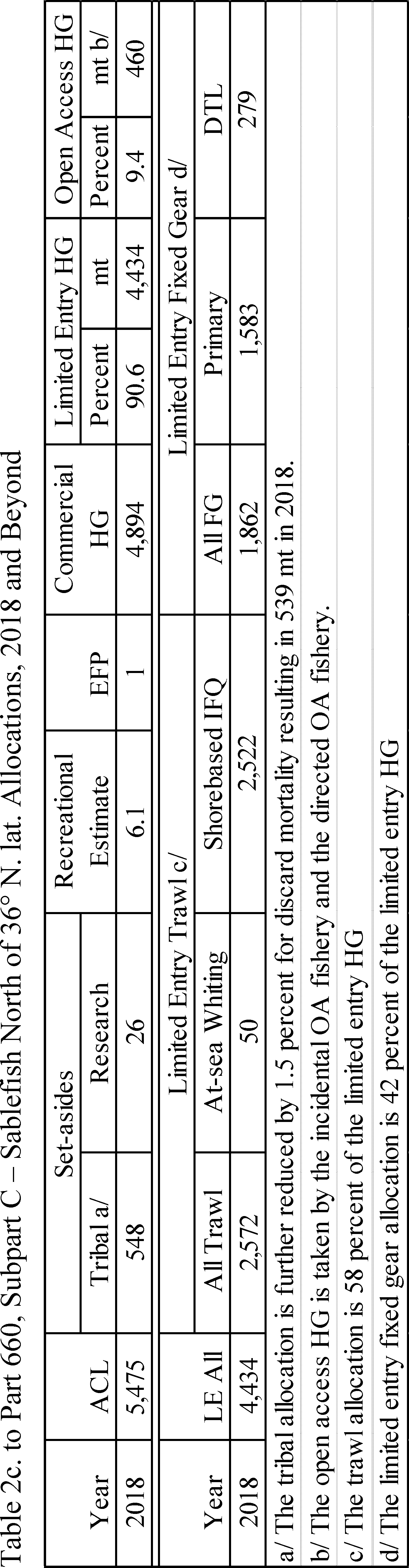
Start Printed Page 9658 Start Amendment Part
13. In § 660.130, paragraph (d)(1)(i) is revised to read as follows:
End Amendment PartStart Amendment PartTrawl fishery-management measures.* * * * *(d) * * *
(1) * * *
(i) Coastwide. Widow rockfish, canary rockfish, darkblotched rockfish, yelloweye rockfish, shortbelly rockfish, black rockfish, blue/deacon rockfish, minor nearshore rockfish, minor shelf rockfish, minor slope rockfish, shortraker rockfish, rougheye/blackspotted rockfish, shortspine and longspine thornyhead, Dover sole, arrowtooth flounder, petrale sole, starry flounder, English sole, other flatfish, lingcod, sablefish, Pacific cod, spiny dogfish, other fish, longnose skate, Pacific whiting, and big skate.
* * * * *14. In § 660.140, paragraphs (d)(1)(ii)(D) and (e)(4)(i) are revised to read as follows:
End Amendment PartStart Amendment PartShorebased IFQ Program.* * * * *(d) * * *
(1) * * *
(ii) * * *
(D) For the trawl fishery, NMFS will issue QP based on the following shorebased trawl allocations:
IFQ species Area 2017 shorebased trawl allocation (mt) 2018 shorebased trawl allocation (mt) Arrowtooth flounder Coastwide 11,050.6 10,992.6 BOCACCIO South of 40°10′ N. lat 302.4 283.3 Canary rockfish Coastwide 1,014.1 1,014.1 Chilipepper South of 40°10′ N. lat 1,920.8 1,845.8 COWCOD South of 40°10′ N. lat 1.40 1.40 DARKBLOTCHED ROCKFISH Coastwide 507.6 518.4 Dover sole Coastwide 45,981.0 45,981.0 English sole Coastwide 9,258.6 6,953.0 Lingcod North of 40°10′ N. lat 1,359.7 1,259.32 Lingcod South of 40°10′ N. lat 558.9 510.75 Longspine thornyhead North of 34°27′ N. lat 2,699.8 2,560.2 Minor Shelf Rockfish complex North of 40°10′ N. lat 1,148.1 1,146.8 Minor Shelf Rockfish complex South of 40°10′ N. lat 192.2 192.4 Minor Slope Rockfish complex North of 40°10′ N. lat 1,268.8 1,268.0 Minor Slope Rockfish complex South of 40°10′ N. lat 432.7 433.9 Other Flatfish complex Coastwide 7,455.4 6,349.3 Pacific cod Coastwide 1,031.4 1,031.4 PACIFIC OCEAN PERCH North of 40°10′ N. lat 198.3 198.3 Pacific whiting Coastwide Petrale sole Coastwide 2,745.3 2,628.5 Sablefish North of 36° N. lat 2,416.4 2,521.9 Sablefish South of 36° N. lat 780.8 814.4 Shortspine thornyhead North of 34°27′ N. lat 1551.3 1,537.0 Shortspine thornyhead South of 34°27′ N. lat 50.0 50.0 Splitnose rockfish South of 40°10′ N. lat 1661.8 1,662.8 Starry flounder Coastwide 630.9 630.9 Widow rockfish Coastwide 11,392.7 10,661.5 YELLOWEYE ROCKFISH Coastwide 1.10 1.10 Yellowtail rockfish North of 40°10′ N. lat 4,246.1 4,075.4 * * * * *(e) * * *
(4) * * *
(i) Vessel limits. For each IFQ species or species group specified in this paragraph, vessel accounts may not have QP or IBQ pounds in excess of the QP vessel limit (annual limit) in any year, and, for species covered by unused QP vessel limits (daily limit), may not have QP or IBQ pounds in excess of the unused QP vessel limit at any time. The QP vessel limit (annual limit) is calculated as all QPs transferred in minus all QPs transferred out of the vessel account. The unused QP vessel limits (daily limit) is calculated as unused available QPs plus any pending outgoing transfer of QPs. Vessel Limits are as follows:
Species category QP vessel limit (annual limit) (in percent) Unused QP vessel limit (daily limit) (in percent) Arrowtooth flounder 20 Bocaccio S. of 40°10′ N. lat 15.4 13.2 Canary rockfish 10 Chilipepper S. of 40°10′ N. lat 15 Cowcod S. of 40°10′ N. lat 17.7 17.7 Darkblotched rockfish 6.8 4.5 Dover sole 3.9 English sole 7.5 Lingcod: N. of 40°10′ N. lat 5.3 Start Printed Page 9659 S. of 40°10′ N. lat 13.3 Longspine thornyhead: N. of 34°27′ N. lat 9 Minor Shelf Rockfish complex: N. of 40°10′ N. lat 7.5 S. of 40°10′ N. lat 13.5 Minor Slope Rockfish complex: N. of 40°10′ N. lat 7.5 S. of 40°10′ N. lat 9 Other flatfish complex 15 Pacific cod 20 Pacific halibut (IBQ) N. of 40°10′ N. lat 14.4 5.4 Pacific ocean perch N. of 40°10′ N. lat 6 4 Pacific whiting (shoreside) 15 Petrale sole 4.5 Sablefish: N. of 36° N. lat. (Monterey north) 4.5 S. of 36° N. lat. (Conception area) 15 Shortspine thornyhead: N. of 34°27′ N. lat 9 S. of 34°27′ N. lat 9 Splitnose rockfish S. of 40°10′ N. lat 15 Starry flounder 20 Widow rockfish 8.5 5.1 Yelloweye rockfish 11.4 5.7 Yellowtail rockfish N. of 40°10′ N. lat 7.5 Non-whiting groundfish species 3.2 * * * * *15. Table 1 (North) and 1 (South) to Part 660, Subpart D, are revised to read as follows:
End Amendment Part Start Printed Page 9660
Start Printed Page 9661
Start Printed Page 9662 Start Amendment Part
16. In § 660.230, paragraph (c)(2)(i) is revised to read as follows:
End Amendment PartStart Amendment PartFixed gear fishery-management measures.* * * * *(c) * * *
(2) * * *
(i) Coastwide—widow rockfish, canary rockfish, darkblotched rockfish, yelloweye rockfish, shortbelly rockfish, black rockfish, blue/deacon rockfish, minor nearshore rockfish, minor shelf rockfish, minor slope rockfish, shortraker rockfish, rougheye/blackspotted rockfish, shortspine and longspine thornyhead, Dover sole, arrowtooth flounder, petrale sole, starry flounder, English sole, other flatfish, lingcod, sablefish, Pacific cod, spiny dogfish, other fish, longnose skate, big skate, and Pacific whiting;
* * * * *17. In § 660.231, paragraph (b)(3)(i) is revised to read as follows:
End Amendment PartStart Amendment PartLimited entry fixed gear sablefish primary fishery.* * * * *(b) * * *
(3) * * *
(i) A vessel participating in the primary season will be constrained by the sablefish cumulative limit associated with each of the permits registered for use with that vessel. During the primary season, each vessel authorized to fish in that season under paragraph (a) of this section may take, retain, possess, and land sablefish, up to the cumulative limits for each of the permits registered for use with that vessel (i.e., stacked permits). If multiple limited entry permits with sablefish endorsements are registered for use with a single vessel, that vessel may land up to the total of all cumulative limits announced in this paragraph for the tiers for those permits, except as limited by paragraph (b)(3)(ii) of this section. Up to 3 permits may be registered for use with a single vessel during the primary season; thus, a single vessel may not take and retain, possess or land more than 3 primary season sablefish cumulative limits in any one year. A vessel registered for use with multiple limited entry permits is subject to per vessel limits for species other than sablefish, and to per vessel limits when participating in the daily trip limit fishery for sablefish under § 660.232. In 2017, the following annual limits are in effect: Tier 1 at 45,120 lb (20,466 kg), Tier 2 at 20,509 mt (9,303 kg), and Tier 3 at 11,720 lb (5,316 kg). In 2018 and beyond, the following annual limits are in effect: Tier 1 at 47,050 lb (21,342 kg), Tier 2 21,386 lb (9,701 kg), and Tier 3 12,221 lb (5,543 kg).
* * * * *18. Tables 2 (North) and 2 (South) to Part 660, Subpart E, are revised to read as follows:
End Amendment Part Start Printed Page 9663
Start Printed Page 9664
Start Printed Page 9665 Start Amendment Part
19. In § 660.330, paragraph (c)(2)(i) is revised to read as follows:
End Amendment PartStart Amendment PartOpen access fishery—management measures.* * * * *(c) * * *
(2) * * *
(i) Coastwide—widow rockfish, canary rockfish, darkblotched rockfish, yelloweye rockfish, shortbelly rockfish, black rockfish, blue/deacon rockfish, minor nearshore rockfish, minor shelf rockfish, minor slope rockfish, shortraker rockfish, rougheye/blackspotted rockfish, shortspine and longspine thornyhead, Dover sole, arrowtooth flounder, petrale sole, starry flounder, English sole, other flatfish, lingcod, sablefish, Pacific cod, spiny dogfish, longnose skate, other fish, Pacific whiting, big skate, and Pacific sanddabs;
* * * * *20. Tables 3 (North) and 3 (South) to Part 660, Subpart F, are revised to read as follows:
End Amendment Part Start Printed Page 9666
Start Printed Page 9667
Start Printed Page 9668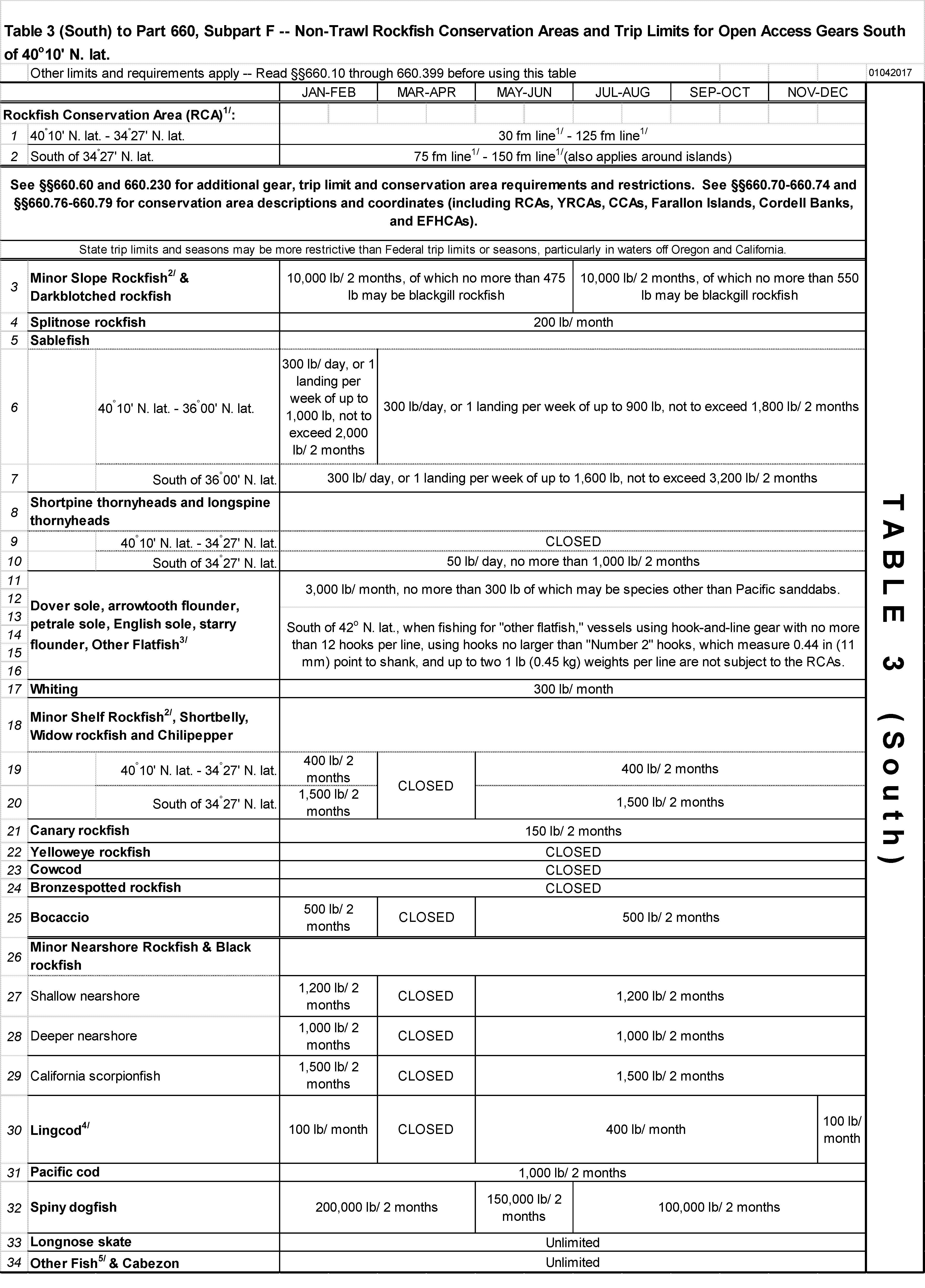
Start Amendment Part
21. In § 660.360, paragraphs (c)(1) introductory text, (c)(1)(i)(D)( 3), (c)(1)(ii), (c)(1)(iv)(A) and (B), (c)(2)(i)(A) and (B), (c)(2)(iii)(A), (c)(2)(iii)(D), (c)(3) introductory text, (c)(3)(i)(A), (c)(3)(ii)(A)(1) through (4), (c)(3)(ii)(B), (c)(3)(iii)(A)(1) through (5), (c)(3)(iii)(B), (c)(3)(iv), and (c)(3)(v)(A)(1) are revised to read as follows:
End Amendment PartEnd Supplemental InformationRecreational fishery—management measures.* * * * *(c) * * *
(1) Washington. For each person engaged in recreational fishing off the coast of Washington, the groundfish bag limit is 12 groundfish per day, including rockfish, cabezon and lingcod. Within the groundfish bag limit, there are sub-limits for rockfish, lingcod, and cabezon outlined in paragraph (c)(1)(i)(D) of this section. The recreational groundfish fishery will open the second Saturday in March through the third Saturday in October for all species in all areas except lingcod in Marine Area 4 as described in paragraph (c)(1)(iv) of this section. In the Pacific halibut fisheries, retention of groundfish is governed in part by annual management measures for Pacific halibut fisheries, which are published in the Federal Register. The following seasons, closed areas, sub-limits and size limits apply:
(i) * * *
(D) * * *
(3) Between Leadbetter Point (46°38.17′ N. lat.) and the Columbia River (Marine Area 1), when Pacific halibut are onboard the vessel, no groundfish may be taken and retained, possessed or landed, except sablefish, flatfish species (except halibut), and Pacific cod from May 1 through September 30. Except that taking, retaining, possessing or landing incidental halibut with groundfish on board is allowed in the nearshore area on days not open to all-depth Pacific halibut fisheries in the area shoreward of the boundary line approximating the 30 fathom (55 m) depth contour extending from Leadbetter Point, WA (46°38.17′ N. lat., 124°15.88′ W. long.) to the Columbia River (46°16.00′ N. lat., 124°15.88′ W. long.) and from there, connecting to the boundary line approximating the 40 fathom (73 m) depth contour in Oregon. Nearshore season days are established in the annual management measures for Pacific halibut fisheries, which are published in the Federal Register and are announced on the NMFS halibut hotline, 1-800-662-9825. Between Leadbetter Point (46°38.17′ N. lat. 124°21.00′ W. long) and 46°33.00′ N. lat. 124°21.00′ W. long., recreational fishing for lingcod is prohibited year round seaward of a straight line connecting all of the following points in the order stated: 46°38.17′ N. lat., 124°21.00′ W. long.; and 46°33.00′ N. lat., 124°21.00′ W. long.
(ii) Rockfish. In areas of the EEZ seaward of Washington that are open to recreational groundfish fishing, there is a 10 rockfish per day bag limit. In Marine Areas 1 and 2 there is a 1 fish sub-bag limit per day for canary rockfish. Taking and retaining canary rockfish is prohibited in Marine Areas 3 and 4. Taking and retaining yelloweye rockfish is prohibited in all Marine areas.
* * * * *(iv) * * *
(A) Between the U.S./Canada border and 48°10′ N. lat. (Cape Alava) (Washington Marine Area 4), recreational fishing for lingcod is open, Start Printed Page 9669for 2017 and 2018, from April 16 through October 15. Lingcod may be no smaller than 22 inches (61 cm) total length.
(B) Between 48°10′ N. lat. (Cape Alava) and 46°16′ N. lat. (Columbia River) (Washington Marine Areas 1-3), recreational fishing for lingcod is open for 2017 from March 11 through October 21, and for 2018 from March 10 through October 20. Lingcod may be no smaller than 22 inches (56 cm) total length.
* * * * *(2) * * *
(i) * * *
(A) Stonewall Bank yelloweye rockfish conservation area. Recreational fishing for groundfish and halibut is prohibited within the Stonewall Bank YRCA. It is unlawful for recreational fishing vessels to take and retain, possess, or land groundfish taken with recreational gear within the Stonewall Bank YRCA. A vessel fishing in the Stonewall Bank YRCA may not be in possession of any groundfish. Recreational vessels may transit through the Stonewall Bank YRCA with or without groundfish on board. The Stonewall Bank YRCA, and two possible expansions that are available through inseason adjustment, are defined by latitude and longitude coordinates specified at § 660.70, subpart C.
(B) Recreational rockfish conservation area. Fishing for groundfish with recreational gear is prohibited within the recreational RCA, a type of closed area or GCA. It is unlawful to take and retain, possess, or land groundfish taken with recreational gear within the recreational RCA. A vessel fishing in the recreational RCA may not be in possession of any groundfish. [For example, if a vessel fishes in the recreational salmon fishery within the RCA, the vessel cannot be in possession of groundfish while in the RCA. The vessel may, however, on the same trip fish for and retain groundfish shoreward of the RCA on the return trip to port.] Off Oregon, from April 1 through September 30, recreational fishing for groundfish is prohibited seaward of a recreational RCA boundary line approximating the 40 fm (73 m) depth contour, except that fishing for flatfish (other than Pacific halibut) is allowed seaward of the 40 fm (73 m) depth contour when recreational fishing for groundfish is permitted. Coordinates for the boundary line approximating the 40 fm (73 m) depth contour are listed at § 660.71.
* * * * *(iii) * * *
(A) Marine fish. The bag limit is 10 marine fish per day, which includes rockfish, kelp greenling, cabezon and other groundfish species. The bag limit of marine fish excludes Pacific halibut, salmonids, tuna, perch species, sturgeon, sanddabs, flatfish, lingcod, striped bass, hybrid bass, offshore pelagic species and baitfish (herring, smelt, anchovies and sardines). The minimum size for cabezon retained in the Oregon recreational fishery is 16 in (41 cm) total length.
* * * * *(D) In the Pacific halibut fisheries. Retention of groundfish is governed in part by annual management measures for Pacific halibut fisheries, which are published in the Federal Register. Between the Columbia River and Humbug Mountain, during days open to the “all-depth” sport halibut fisheries, when Pacific halibut are onboard the vessel, no groundfish may be taken and retained, possessed or landed, except sablefish, Pacific cod, and other species of flatfish (sole, flounder, sanddab). “All-depth” season days are established in the annual management measures for Pacific halibut fisheries, which are published in the Federal Register and are announced on the NMFS Pacific halibut hotline, 1-800-662-9825.
* * * * *(3) California. Seaward of California, California law provides that, in times and areas when the recreational fishery is open, there is a 20 fish bag limit for all species of finfish, within which no more than 10 fish of any one species may be taken or possessed by any one person. [Note: There are some exceptions to this rule. The following groundfish species are not subject to a bag limit: Petrale sole, Pacific sanddab and starry flounder.] For groundfish species not specifically mentioned in this paragraph, fishers are subject to the overall 20-fish bag limit for all species of finfish and the depth restrictions at paragraph (c)(3)(i) of this section. Recreational spearfishing for all federally-managed groundfish, is exempt from closed areas and seasons, consistent with Title 14 of the California Code of Regulations. This exemption applies only to recreational vessels and divers provided no other fishing gear, except spearfishing gear, is on board the vessel. California state law may provide regulations similar to Federal regulations for the following state-managed species: Ocean whitefish, California sheephead, and all greenlings of the genus Hexagrammos. Kelp greenling is the only federally-managed greenling. Retention of cowcod, yelloweye rockfish, and bronzespotted rockfish, is prohibited in the recreational fishery seaward of California all year in all areas. Retention of species or species groups for which the season is closed is prohibited in the recreational fishery seaward of California all year in all areas, unless otherwise authorized in this section. For each person engaged in recreational fishing in the EEZ seaward of California, the following closed areas, seasons, bag limits, and size limits apply:
(i) * * *
(A) Recreational rockfish conservation areas. The recreational RCAs are areas that are closed to recreational fishing for groundfish. Fishing for groundfish with recreational gear is prohibited within the recreational RCA, except that recreational fishing for “other flatfish,” petrale sole, and starry flounder is permitted within the recreational RCA as specified in paragraph (c)(3)(iv) of this section. It is unlawful to take and retain, possess, or land groundfish taken with recreational gear within the recreational RCA, unless otherwise authorized in this section. A vessel fishing in the recreational RCA may not be in possession of any species prohibited by the restrictions that apply within the recreational RCA. [For example, if a vessel fishes in the recreational salmon fishery within the RCA, the vessel cannot be in possession of rockfish while in the RCA. The vessel may, however, on the same trip fish for and retain rockfish shoreward of the RCA on the return trip to port.] If the season is closed for a species or species group, fishing for that species or species group is prohibited both within the recreational RCA and shoreward of the recreational RCA, unless otherwise authorized in this section.
(1) Between 42° N. lat. (California/Oregon border) and 40°10′ N. lat. (Northern Management Area), recreational fishing for all groundfish (except petrale sole, starry flounder, and “other flatfish” as specified in paragraph (c)(3)(iv) of this section) is prohibited seaward of the 30 fm (55 m) depth contour along the mainland coast and along islands and offshore seamounts from May 1 through October 31 (shoreward of 30 fm is open); is open at all depths from November 1 through December 31; and is closed entirely from January 1 through April 30.
(2) Between 40°10′ N. lat. and 38°57.50′ N. lat. (Mendocino Management Area), recreational fishing for all groundfish (except petrale sole, starry flounder, and “other flatfish” as specified in paragraph (c)(3)(iv) of this section) is prohibited seaward of the 20 fm (37 m) depth contour along the mainland coast and along islands and offshore seamounts from May 1 through October 31 (shoreward of 20 fm is Start Printed Page 9670open), is open at all depths from November 1 through December 31, and is closed entirely from January 1 through April 30.
(3) Between 38°57.50′ N. lat. and 37°11′ N. lat. (San Francisco Management Area), recreational fishing for all groundfish (except petrale sole, starry flounder, and “other flatfish” as specified in paragraph (c)(3)(iv) of this section) is prohibited seaward of the boundary line approximating the 40 fm (73 m) depth contour along the mainland coast and along islands and offshore seamounts from April 15 through December 31; and is closed entirely from January 1 through April 14. Closures around Cordell Banks (see paragraph (c)(3)(i)(C) of this section) also apply in this area. Coordinates for the boundary line approximating the 40 fm (73 m) depth contour are listed in § 660.71.
(4) Between 37°11′ N. lat. and 34°27′ N. lat. (Central Management Area), recreational fishing for all groundfish (except petrale sole, starry flounder, and “other flatfish” as specified in paragraph (c)(3)(iv) of this section) is prohibited seaward of a boundary line approximating the 50 fm (91 m) depth contour along the mainland coast and along islands and offshore seamounts from April 1 through December 31; and is closed entirely from January 1 through March 31 (i.e., prohibited seaward of the shoreline). Coordinates for the boundary line approximating the 50 fm (91 m) depth contour are specified in § 660.72.
(5) South of 34°27′ N. lat. (Southern Management Area), recreational fishing for all groundfish (except California scorpionfish as specified below in this paragraph and in paragraph (c)(3)(v) of this section and “other flatfish,” petrale sole, and starry flounder, as specified in paragraph (c)(3)(iv) of this section) is prohibited seaward of a boundary line approximating the 60 fm (109.7 m) depth contour from March 1 through December 31 along the mainland coast and along islands and offshore seamounts, except in the CCAs where fishing is prohibited seaward of the 20 fm (37 m) depth contour when the fishing season is open (see paragraph (c)(3)(i)(B) of this section). Recreational fishing for all groundfish (except California scorpionfish, “other flatfish,” petrale sole, and starry flounder) is closed entirely from January 1 through February 28 (i.e., prohibited seaward of the shoreline). When the California scorpionfish fishing season is open, recreational fishing for California scorpionfish south of 34°27′ N. lat. is prohibited seaward of a boundary line approximating the 60 fm (109.7 m) depth contour, except in the CCAs where fishing is prohibited seaward of the 20 fm (37 m) depth contour.
* * * * *(ii) * * *
(A) * * *
(1) Between 42° N. lat. (California/Oregon border) and 40°10′ N. lat. (North Management Area), recreational fishing for the RCG complex is open from May 1 through December 31 (i.e., it's closed from January 1 through April 30).
(2) Between 40°10′ N. lat. and 38°57.50′ N. lat. (Mendocino Management Area), recreational fishing for the RCG Complex is open from May 1 through October December 31 (i.e., it's closed from January 1 through April 30).
(3) Between 38°57.50′ N. lat. and 37°11′ N. lat. (San Francisco Management Area), recreational fishing for the RCG complex is open from April 15 through December 31 (i.e., it's closed from January 1 through April 14).
(4) Between 37°11′ N. lat. and 34°27′ N. lat. (Central Management Area), recreational fishing for the RCG complex is open from April 1 through December 31 (i.e., it's closed from January 1 through March 31).
* * * * *(B) Bag limits, hook limits. In times and areas when the recreational season for the RCG Complex is open, there is a limit of 2 hooks and 1 line when fishing for the RCG complex and lingcod. The bag limit is 10 RCG Complex fish per day coastwide. Retention of yelloweye rockfish, bronzespotted rockfish, and cowcod is prohibited. Within the 10 RCG Complex fish per day limit, no more than 3 may be black rockfish, no more than 3 may be cabezon, and no more than 1 may be canary rockfish. Multi-day limits are authorized by a valid permit issued by California and must not exceed the daily limit multiplied by the number of days in the fishing trip.
* * * * *(iii) * * *
(A) * * *
(1) Between 42° N. lat. (California/Oregon border) and 40°10′ N. lat. (Northern Management Area), recreational fishing for lingcod is open from May 1 through December 31 (i.e., it's closed from January 1 through April 30).
(2) Between 40°10′ N. lat. and 38°57.50′ N. lat. (Mendocino Management Area), recreational fishing for lingcod is open from May 1 through December 31 (i.e., it's closed from January 1 through April 30).
(3) Between 38°57.50′ N. lat. and 37°11′ N. lat. (San Francisco Management Area), recreational fishing for lingcod is open from April 15 through December 31 (i.e., it's closed from January 1 through April 14).
(4) Between 37°11′ N. lat. and 34°27′ N. lat. (Central Management Area), recreational fishing for lingcod is open from April 1 through December 31 (i.e., it's closed from January 1 through March 31).
(5) South of 34°27′ N. lat. (Southern Management Area), recreational fishing for lingcod is open from March 1 through December 31 (i.e., it's closed from January 1 through February 28).
(B) Bag limits, hook limits. In times and areas when the recreational season for lingcod is open, there is a limit of 2 hooks and 1 line when fishing for lingcod. The bag limit is 2 lingcod per day. Multi-day limits are authorized by a valid permit issued by California and must not exceed the daily limit multiplied by the number of days in the fishing trip.
* * * * *(iv) “Other flatfish,” petrale sole, and starry flounder. Coastwide off California, recreational fishing for “other flatfish,” petrale sole, and starry flounder, is permitted both shoreward of and within the closed areas described in paragraph (c)(3)(i) of this section. “Other flatfish” are defined at § 660.11, subpart C, and include butter sole, curlfin sole, flathead sole, Pacific sanddab, rex sole, rock sole, and sand sole. Recreational fishing for “other flatfish,” petrale sole, and starry flounder, is permitted within the closed areas. Petrale sole, starry flounder, and “Other flatfish,” except Pacific sanddab, are subject to the overall 20-fish bag limit for all species of finfish, of which there may be no more than 10 fish of any one species. There is no season restriction or size limit for “other flatfish,” petrale sole, and starry flounder however, it is prohibited to filet “other flatfish,” petrale sole, and starry flounder, at sea.
(v) * * *
(A) * * *
(1) Between 40°10′ N. lat. and 38°57.50′ N. lat. (Mendocino Management Area), recreational fishing for California scorpionfish is open from May 1 through August 31 (i.e., it's closed from January 1 through April 30 and from September 1 through December 31).
* * * * *BILLING CODE 3510-22-P
BILLING CODE 3510-22-C
BILLING CODE 3510-22-P
BILLING CODE 3510-22-C
BILLING CODE 3510-22-P
BILLING CODE 3510-22-C
BILLING CODE 3510-22-P
BILLING CODE 3510-22-C
[FR Doc. 2017-02268 Filed 2-6-17; 8:45 am]
BILLING CODE 3510-22-P


Document Information
- Effective Date:
- 2/7/2017
- Published:
- 02/07/2017
- Department:
- National Oceanic and Atmospheric Administration
- Entry Type:
- Rule
- Action:
- Final rule.
- Document Number:
- 2017-02268
- Dates:
- This final rule is effective February 7, 2017.
- Pages:
- 9634-9670 (37 pages)
- Docket Numbers:
- Docket No. 160808696-7010-02
- RINs:
- 0648-BG17: Magnuson-Stevens Act Provisions; Fisheries off West Coast States; Pacific Coast Groundfish Fishery; Specifications and Management Measures and Fishery Management Plan Amendment 27
- RIN Links:
- https://www.federalregister.gov/regulations/0648-BG17/magnuson-stevens-act-provisions-fisheries-off-west-coast-states-pacific-coast-groundfish-fishery-spe
- Topics:
- Fisheries, Fishing, Reporting and recordkeeping requirements
- PDF File:
- 2017-02268.pdf
- Supporting Documents:
- » Fisheries of the Exclusive Economic Zone Off Alaska: Inseason Adjustment to the 2021 Gulf of Alaska Pollock and Pacific Cod Total Allowable Catch Amounts
- » Fisheries of the Northeastern United States: Summer Flounder, Scup, and Black Sea Bass 2021 Specifications
- » Fisheries of the Northeastern United States: Atlantic Bluefish Fishery; Quota Transfer from MD to NC
- » Fisheries of the Northeastern United States: Amendment 21 to the Atlantic Mackerel, Squid, and Butterfish Fishery Management Plan; Correction
- » Fisheries of the Caribbean, Gulf of Mexico, and South Atlantic: Electronic Reporting for Federally Permitted Charter Vessels and Headboats in Atlantic Fisheries
- » Fisheries of the Northeastern United States: Illex Squid Fishery; Revised 2020 Illex Squid Specifications
- » Fisheries of the Caribbean, Gulf of Mexico, and South Atlantic: Electronic Reporting for Federally Permitted Charter Vessels and Headboats in Gulf of Mexico Fisheries
- » Pacific Halibut Fisheries: Catch Sharing Plan
- » Vessel Monitoring Systems: Requirements for Type-Approval of Cellular Transceiver Units
- » Taking and Importing Marine Mammals: Incidental to the U.S. Navy Training and Testing Activities in the Atlantic Fleet Training and Testing Study Area
- CFR: (15)
- 50 CFR 660.11
- 50 CFR 660.40
- 50 CFR 660.50
- 50 CFR 660.55
- 50 CFR 660.60
- More ...