05-11847. Taking of Marine Mammals Incidental to Commercial Fishing Operations; Atlantic Large Whale Take Reduction Plan Regulations
-
Start Preamble
Start Printed Page 35894
AGENCY:
National Marine Fisheries Service (NMFS), National Oceanic and Atmospheric Administration (NOAA), Commerce.
ACTION:
Proposed rule; request for comments.
SUMMARY:
The National Marine Fisheries Service (NMFS) proposes to amend the regulations implementing the Atlantic Large Whale Take Reduction Plan (ALWTRP), to revise the management measures for reducing the incidental mortality and serious injury to the North Atlantic right whale (Eubalaena glacialis), humpback whale (Megaptera novaeangliae), and fin whale (Balaenoptera physalus) in commercial fisheries to meet the goals of the Marine Mammal Protection Act (MMPA) and the Endangered Species Act (ESA). NMFS proposes additional regulations for the fisheries currently covered by the ALWTRP, which include the Northeast sink gillnet, Northeast/Mid-Atlantic American lobster trap/pot, U.S. Mid-Atlantic coastal gillnet, Southeast Atlantic gillnet, and Southeastern U.S. Atlantic shark gillnet fisheries. NMFS also proposes to regulate the following fisheries from the MMPA's List of Fisheries for the first time under the ALWTRP: Northeast anchored float gillnet, Northeast drift gillnet, Atlantic blue crab, and Atlantic mixed species trap/pot fisheries targeting crab (red, Jonah, and rock), hagfish, finfish (black sea bass, scup, tautog, cod, haddock, pollock, redfish (ocean perch), and white hake), conch/whelk, and shrimp.
DATES:
Comments on the proposed rule must be received by 5 p.m. EST on July 21, 2005.
ADDRESSES:
Comments may be submitted on this proposed rule, identified by RIN 0648-AS01, by any one of the following methods:
(1) NMFS/Northeast Region Web site: http://www.nero.noaa.gov/nero/regs/com. Follow the instructions on the Web site for submitting comments.
(2) Federal eRulemaking Portal: http://www.regulations.gov. Follow the instruction on the Web site for submitting comments.
(3) E-mail: whalerule.comments@noaa.gov. Please include the RIN 0648-AS01 in the subject line of the message.
(4) Mail: Mary Colligan, Assistant Regional Administrator for Protected Resources, NMFS, Northeast Region, 1 Blackburn Dr., Gloucester, MA 01930, ATTN: ALWTRP Proposed Rule.
(5) Facsimile (fax) to: 978-281-9394, ATTN: ALWTRP Proposed Rule.
Copies of the Draft Environmental Impact Statement/Regulatory Impact Review for this action can be obtained from the ALWTRP Web site listed under the Electronic Access portion of this document. Atlantic Large Whale Take Reduction Team (ALWTRT) meeting summaries, and progress reports on implementation of the ALWTRP may be obtained by writing Diane Borggaard, NMFS, Northeast Region, 1 Blackburn Dr., Gloucester, MA 01930 or Juan Levesque, NMFS, Southeast Region, 9721 Executive Center Dr., St. Petersburg, FL 33702-2432. For additional addresses and Web sites for document availability see SUPPLEMENTARY INFORMATION.
Start Further InfoFOR FURTHER INFORMATION CONTACT:
Diane Borggaard, NMFS, Northeast Region, 978-281-9300 Ext. 6503, diane.borggaard@noaa.gov; Kristy Long, NMFS, Office of Protected Resources, 301-713-2322, kristy.long@noaa.gov; or Barb Zoodsma, NMFS, Southeast Region, 904-321-2806, barb.zoodsma@noaa.gov.
End Further Info End Preamble Start Supplemental InformationSUPPLEMENTARY INFORMATION:
Electronic Access
Several of the background documents for the ALWTRP and the take reduction planning process can be downloaded from the ALWTRP Web site at http://www.nero.noaa.gov/whaletrp/. Copies of the most recent marine mammal stock assessment reports may be obtained by writing to Richard Merrick, NMFS, 166 Water St., Woods Hole, MA 02543 or can be downloaded from the Internet at http://www.nefsc.noaa.gov/psb/assesspdfs.htm. In addition, copies of the documents entitled “Defining Triggers for Temporary Area Closures to Protect Right Whales from Entanglements: Issues and Options” and “Identification of Seasonal Area Management Zones for North Atlantic Right Whale Conservation” are available by writing to Diane Borggaard, NMFS, Northeast Region, 1 Blackburn Dr., Gloucester, MA 01930 or can be downloaded from the ALWTRP Web site at http://www.nero.noaa.gov/whaletrp/. The complete text of the regulations implementing the ALWTRP can be found either in the Code of Federal Regulations (CFR) at 50 CFR 229.32 or downloaded from the Web site, along with a guide to the regulations.
Background
The ALWTRP was originally developed pursuant to section 118 of the Marine Mammal Protection Act (MMPA) to reduce the level of serious injury and mortality of three strategic stocks of large whales (fin, humpback, and North Atlantic right) interacting with Category I and II fisheries (i.e., those with frequent or occasional serious injury or mortality of marine mammals). The MMPA defines a strategic stock of marine mammals as a stock: (1) For which the level of direct human-caused mortality exceeds the Potential Biological Removal (PBR) level; (2) which, based on the best available scientific information, is declining and is likely to be listed as a threatened species under the ESA within the foreseeable future; or (3) which is listed as a threatened or endangered species under the ESA, or as depleted under the MMPA (16 U.S.C. 1362(19)). Specific Category I and II fisheries under the original ALWTRP included the New England Multispecies sink gillnet (now called Northeast sink gillnet), Gulf of Maine/U.S. Mid-Atlantic lobster trap/pot (now called Northeast/Mid-Atlantic American lobster trap/pot), U.S. Mid-Atlantic coastal gillnet, and Southeastern U.S. Atlantic shark gillnet fisheries. The measures identified in the ALWTRP were also intended to benefit minke whales (Balaenoptera acutorostrata), which are not strategic, but are known to be taken incidentally in gillnet and American lobster trap/pot fisheries.
In general, the ALWTRP has consisted of a combination of regulatory and non-regulatory measures, including broad gear modifications, time-area closures, expanded disentanglement efforts, extensive outreach efforts in key areas, gear research, and an expanded right whale surveillance program to supplement the Mandatory Ship Reporting System. The background for the take reduction planning process and initial development of the ALWTRP is provided in the preambles to the proposed (62 FR 16519, April 7, 1997), interim final (62 FR 39157, July 22, 1997), and final (64 FR 7529, February 16, 1999) rules that implemented the original plan.
Since its implementation in 1997, the ALWTRP has been modified several Start Printed Page 35895times to reduce the serious injury and mortality of large whales in gillnet and American lobster trap/pot gear. An interim final rule published in December 2000 (65 FR 80368, December 21, 2000) and a final rule in January 2002 (67 FR 1300, January 10, 2002; 67 FR 15493, April 2, 2002), contain background information on changes to the ALWTRP that implemented additional gear modifications. In 2002, a final rule added the Southeast Atlantic gillnet fishery to those fisheries regulated by the ALWTRP, restricting the use of straight set gillnets at night in the Southeast U.S. Restricted Area (67 FR 59471, September 23, 2002; 68 FR 19464, April 21, 2003). An interim final rule implemented a Seasonal Area Management (SAM) program (67 FR 1142, January 9, 2002; 67 FR 65722, October 28, 2002), which identified two management areas based on the annual predictable presence of right whales and required gear modifications for lobster trap/pot and anchored gillnet gear in these areas on a seasonal basis. Additionally, in 2002, a final rule implemented a Dynamic Area Management (DAM) program (67 FR 1133, January 9, 2002; 67 FR 65722, October 28, 2002) to protect unexpected aggregations of right whales that met appropriate criteria by temporarily restricting lobster trap/pot and anchored gillnet fishing in a designated area. A final rule published in August 2003 (68 FR 10195, March 4, 2003; 68 FR 51195, August 26, 2003) identified gear modifications determined to sufficiently reduce the risk of entanglement to right whales, and, therefore, deemed acceptable for fishing in DAM zones. Copies of the above documents and their supporting Environmental Assessments are available from the NMFS, Northeast Region (see ADDRESSES).
ESA Section 7 Consultation and the ALWTRP
As described above, the ALWTRP was developed under section 118 of the MMPA and subsequently modified to comply with the purposes and policies of the MMPA. However, the three whale species directly protected by the ALWTRP (fin, humpback, and North Atlantic right) are also listed under the Endangered Species Act (ESA)(16 U.S.C. 1531 et seq.). In addition, many of the fisheries affected by the ALWTRP are subject to interagency consultation under section 7 of the ESA since the fisheries occur (at least in part) in Federal waters and are federally managed. These include the American lobster, black sea bass, and deep-sea red crab trap/pot fisheries; and the Northeast multispecies, monkfish, spiny dogfish, bluefish, southeastern U.S. Atlantic shark, and southeast Atlantic coastal pelagic gillnet fisheries.
Section 7 of the ESA requires Federal agencies to ensure that their actions (e.g., implementation of fishery management measures) do not jeopardize the continued existence of ESA-listed species. The process for determining whether a Federal agency action will jeopardize any ESA-listed species is referred to as “section 7 consultation.” In 1996, NMFS completed section 7 consultations for the American lobster trap/pot fishery and the Northeast multispecies gillnet fishery and concluded that the operation of these fisheries would jeopardize the continued existence of North Atlantic right whales as a result of serious injuries and mortalities occurring within lobster trap/pot and multispecies sink gillnet gear. NMFS also concluded that the new ALWTRP measures would modify these fisheries in such a way that jeopardy would be avoided. NMFS, therefore, accepted the ALWTRP measures as a reasonable and prudent alternative (RPA) to avoid jeopardy to right whales from these two fisheries.
Similarly, following section 7 consultation on the Monkfish Fishery Management Plan (FMP) and Spiny Dogfish FMP in 1998 and 1999, respectively, NMFS concluded that the existing ALWTRP measures would avoid the likelihood that the gillnet component of these fisheries would jeopardize the continued existence of North Atlantic right whales.
In 2000, NMFS reinitiated section 7 consultation for the Federal lobster, Northeast multispecies, monkfish, and spiny dogfish fisheries after receiving new information that indicated right whale population status was declining (Caswell et al., 1999), whale entanglements resulting in serious injuries were still occurring, and a recent right whale death resulted from entanglement in gillnet gear. Section 7 consultation for each of the four fisheries was completed on June 14, 2001, and concluded that the existing ALWTRP measures were not sufficient to remove the likelihood of jeopardy for North Atlantic right whales. A new RPA was developed for the four fisheries and included SAM, DAM, and additional gear modifications. These measures were implemented through rulemaking as part of the ALWTRP. The RPA also included monitoring criteria (a non-regulatory measure) to help assess the effectiveness of the RPA.
In 2002, eight right whales were observed entangled after implementation of the RPA measures. One of the eight, a female right whale born in 2000 (RW #3107), had line with an attached buoy wrapped around and cutting into her tail stock. Several disentanglement attempts were made and she was subsequently freed of the gear. The recovered gear was examined to obtain further information on the entanglement event. NMFS could not positively identify the fishery or owner of the gear. However, based on the examination, NMFS concluded that the gear was consistent with that used in the inshore lobster trap fishery (Whittingham et al., 2003). [On July 30, 2003, NOAA Fisheries gear specialist clarified that the term “inshore lobster trap fishery” as used in the draft 2002 Large Whale Entanglement Report refers to U.S. waters that include northern inshore (certain state waters), northern nearshore, and southern nearshore waters as they are defined under the ALWTRP.] This conclusion was based on the configuration of the recovered gear, including the presence of a weak link with a breaking strength of no more than 600 lb (272.4 kg). Six weeks after the disentanglement, her carcass washed ashore on Nantucket, MA.
Although the exact cause of death could not be determined, the necropsy of RW #3107 did reveal substantial tissue damage to the tail stock in the area where the entangling gear had been present. A draft necropsy report describes the most likely cause of death (based on the available evidence) as an infection or other debilitating condition caused by the injuries to the tail stock.
NMFS reviewed the necropsy report and considered whether it provided sufficient information to show, based on RPA monitoring criteria, that the RPA was not effective at avoiding the likelihood of jeopardy to right whales. On June 13, 2003, NMFS received confirmation from the Northeast Fisheries Science Center (NEFSC) that the Atlantic Scientific Review Group (ASRG) concurred with the NEFSC finding that the death of RW #3107 was an entanglement related mortality. [The ASRG is 1 of 3 independent regional scientific review groups composed of individuals, in part, with expertise in marine mammal biology and ecology, population dynamics and modeling, and commercial fishing technology and practices. The review groups were established as required by section 117 of the MMPA, and serve as advisors to NOAA Fisheries and the FWS with respect to marine mammal issues.]
There is no way to determine exactly when and where RW #3107 became entangled. She was last seen prior to the entanglement in December 2001 off of Start Printed Page 35896South Carolina. She was next seen (entangled) in July 2002 in Canadian waters off of Nova Scotia. Although RW #3107 could have become entangled in Canadian waters, NMFS considers this unlikely since Canadian trap fishers (whether for lobster, crab, or fish) are not required to use a 600-lb (272.4-kg) weak link. The more likely scenario is that RW #3107 became entangled in U.S. waters. While it is possible that she became entangled prior to when the RPA measures went into effect, this is somewhat irrelevant since the weak link on the entangling gear was the same breaking strength as is currently required by the RPA for certain lobster fishing areas.
In summary, while the gear recovered from RW #3107 cannot be identified as originating from the U.S. lobster fishery, NMFS has determined that the gear is consistent with gear approved for use in the lobster fishery that is conducted in portions of the U.S. Exclusive Economic Zone (EEZ). In addition, NMFS has been advised that RW #3107 died as a result of injuries caused by the entanglement. Therefore, based on the RPA monitoring criteria from the June 14, 2001, biological opinion, NMFS concluded that the entanglement event for RW #3107 provides evidence that the RPA described in the June 14, 2001, Opinion is not effective at avoiding the likelihood of jeopardizing the continued existence of right whales by the lobster trap fishery. As required, NMFS has reinitiated consultation to reexamine the effects of the fishery, as modified by the existing ALWTRP and RPA measures, on right whales. This consultation is in progress.
NMFS reinitiated section 7 consultation on the Summer Flounder, Scup, Black Sea Bass FMP following new information on the applicability of the ALWTRP measures for federally-permitted black sea bass fishermen using pot/trap gear. This consultation is also in progress.
In the Southeast Region, NMFS has conducted section 7 consultations on the following fishery management plans: Coastal Migratory Pelagics; Swordfish, Tuna, Shark, and Billfish; and Snapper-Grouper. In 1992, the section 7 consultation for Amendment 6 to the Coastal Migratory Pelagics FMP concluded that the proposed actions to regulate pelagic hook-and-line and gillnet fishing gear were not likely to adversely affect ESA-listed species, but that the fishing activities conducted under the authority of the FMP may affect, but were not likely to jeopardize, the continued existence of listed sea turtles. Subsequent consultations conducted on additional amendments to the Coastal Migratory Pelagics FMP and emergency actions have been informal. These informal consultations concluded that the regulatory changes resulting from these additional amendments would not alter the findings presented in the 1992 biological opinion prepared for Amendment 6 to the FMP. In addition, NMFS does not have data indicating that the level of take for sea turtles, as specified in the 1992 incidental take statement, has been exceeded, which would require reinitiating formal consultation. However, due to the listing of new species (e.g., smalltooth sawfish) on the ESA and designation of critical habitat for right whales in the southeast U.S. since 1992, NMFS believes reinitiating formal consultation is warranted and has begun this process.
In 2003, NMFS conducted a section 7 consultation for the Draft Amendment 1 to the Highly Migratory Species FMP. The section 7 consultation concluded that, based on the lack of reported interactions between large whales and the Southeast U.S. Atlantic shark gillnet fishery since the implementation of the ALWTRP and the RPA identified in the May 1997 biological opinion, the proposed action may affect, but is not likely to jeopardize the continued existence of right, humpback, and fin whales.
Since 1989, NMFS has conducted numerous section 7 consultations on the Snapper-Grouper FMP and its subsequent amendments. These consultations have all concluded that the trap/pot gear used by the fisheries managed under the FMP, such as black sea bass pots, were not likely to jeopardize the continued existence of endangered large whales or result in the destruction or adverse modification of critical habitat. In 2000, a section 7 consultation for Amendment 12 to the FMP came to the same conclusion as all the prior consultations, however, NMFS expressed that interactions between hook-and-line and pot gear used by this fishery and endangered marine mammals and sea turtles may warrant further consideration in future amendments. Therefore, NMFS is presently in the process of re-initiating formal consultation on the Snapper-Grouper FMP.
Take Reduction Team Activities During 2003 and 2004
Under the 1994 Amendments to the MMPA, the immediate goal of a take reduction plan (TRP) is to reduce the incidental take of strategic stocks of marine mammals in commercial fishing operations to below PBR within 6 months of implementing a TRP. The long-term goal is to reduce incidental takes to insignificant levels approaching a zero mortality and serious injury rate (69 FR 43338, July 20, 2004) within 5 years of implementing a TRP. For right whales, these two goals are essentially the same since the PBR level is zero. Under the ESA, NMFS is obligated to use its authorities to conserve endangered and threatened species and ensure that actions authorized by the agency, such as fishing in Federal waters, are not likely to jeopardize the continued existence of any endangered or threatened species, including right whales.
NMFS determined that additional modifications to the ALWTRP were warranted based on the continued entanglement of large whales in commercial fishing gear since the 2002 ALWTRP regulations became effective. Therefore, NMFS reconvened the ALWTRT from April 28-30, 2003, to help evaluate the ALWTRP and discuss additional modifications necessary to meet the goals of the MMPA and ESA. NMFS asked the ALWTRT to consider some preliminary options provided in advance of the meeting, as well as develop additional options for addressing incidental interactions between commercial fisheries and large whales. Particular emphasis was placed on those options designed to reduce the potential for entanglements and minimize adverse impacts if entanglements occur.
Following the April 2003 meeting, the ALWTRT met in separate subgroups over the next 2 months to further discuss and refine the proposals developed at the April meeting. These ALWTRT meetings included a “Northeast Inshore Lobster Trap/Pot” subgroup that met on May 19, 2003; an “Offshore Trap/Pot” subgroup that met on June 17, 2003; a “Southeast/Mid-Atlantic” subgroup that met on June 23, 2003; and a “Northeast Gillnet” subgroup met on June 24, 2003. All ALWTRT meetings, including subgroup meetings, were open to the public.
Subsequently, on June 30, 2003, NMFS published a Notice of Intent (NOI) in the Federal Register to announce the agency's intent to prepare an Environmental Impact Statement (EIS) that would analyze the impacts of alternatives for amending the ALWTRP (68 FR 38676). The 2003 NOI expanded the scope of analysis from an NOI previously published in 2001 (66 FR 50390, October 3, 2001), which was issued when NMFS was planning to prepare an EIS to analyze the impacts of alternatives under consideration to finalize the SAM program. In the 2003 NOI, NMFS announced several public Start Printed Page 35897scoping meetings along the east coast to solicit comments on the range of issues to be considered during the preparation of the EIS. Proposals from the April 2003 ALWTRT meeting and subsequent subgroup meetings were used to develop an issues and options document, which NMFS made available to the public during the scoping process. The ALWTRT had agreed on two overriding principles for reducing the risk of interactions between large whales and commercial fisheries; these principles were included in the scoping document. These include the following: (1) Reducing profiles of all groundlines to minimize risk of entanglement and (2) reducing the risk of entanglement associated with vertical lines.
The document also described the major issues, current management and legal requirements, and potential management measures (including measures already in effect) to address fisheries that may frequently or occasionally interact with large whales. During the summer of 2003, NMFS conducted six public scoping meetings along the east coast.
The full ALWTRT met again February 3-4, 2004. NMFS updated team members and interested parties on recent whale conservation activities and research, revisited the ALWTRP principles, and discussed the upcoming rulemaking process, among other issues. At this meeting, similar to the 2003 ALWTRT meeting, much of the discussions focused on ways to reduce the entanglement risk associated with groundlines. To date, the ALWTRT meetings and the scoping meetings associated with the draft EIS (DEIS) process have yielded little from which NMFS could propose effective and comprehensive management measures designed to address the vertical line issue. In fact, at the 2004 ALWTRT meeting, team members highlighted the need for further biological and gear research to develop appropriate management measures for reducing the risk associated with vertical lines. As a result, NMFS is outlining a strategy to reduce interactions with groundlines in this proposed rule, along with some measures to address vertical lines, and plans to further address the risk associated with vertical lines through future rulemaking.
Reducing the Risk of Entanglement Associated With Groundlines
Floating groundline is a source of entanglement for large whales. Underwater video recording of typical trap/pot gear with floating groundline between traps revealed that the line often forms large loops in the water column (an average of 8-18 feet (2.44-5.49 meters) above the bottom) between traps (McKiernan et al., 2002). This slack in the floating line presents an entanglement risk to large whales because they often use the entire water column when foraging. For example, during feeding activities in Cape Cod Bay, three right whales tagged by multi-sensor telemetry units spent up to 31 percent of their time in the bottom third of the water column. During non-feeding activities, whale use in this portion of the water column increased up to 40 percent (Wiley & Goodyear, 1998).
One method proposed at the April 2003 ALWTRT meeting for reducing the groundline entanglement risk centered on lowering the profile of the line to a pre-determined level, which would remove it from the mid- and upper portions of the water column. However, at the February 2004 ALWTRT meeting, a group of large whale researchers proposed that lowering the profile of groundlines to within a few feet of the bottom may not be effective at reducing the risk of large whale entanglements in some areas, particularly areas known to support foraging aggregations of highly endangered right whales. They explained that many of the most serious right whales entanglements involve the head and mouth. These head and mouth entanglements presumably occur during open-mouth feeding activities that may be correlated to a dense layer of zooplankton near the bottom of the seafloor. Therefore, the ALWTRT recommended using sinking or neutrally buoyant groundline in these areas, which would bring groundlines down to the seafloor.
In light of this information, NMFS is unable to support using “low-profile” groundline at this time. Further research and analysis is needed on whether lowering the profile of groundline to depths other than the ocean bottom reduces the potential for large whale entanglement in certain areas. Additionally, NMFS must determine the appropriate depth to which the groundline profile could be reduced. Specifically, further information and analysis are needed on prey distribution, large whale distribution and behavior, and methods for reducing the profile of groundline. NMFS would need to define “Low-profile” line in such a way that it is enforceable, is operationally feasible for fishermen, and reduces the risk of entanglement. Presently, NMFS and others are researching all of these issues. NMFS may consider “low-profile” groundline in the future. Through this proposed rule, NMFS is soliciting comments and information on any of the issues noted above that are related to “low profile” groundline.
Reducing the Risk of Entanglement Associated With Vertical Lines
Although this proposed rule contains alternatives that would require fishermen to convert groundlines from floating line to sinking line and provides a plan for addressing vertical lines in the future, NMFS is proposing a staged approach to the implementation of gear modifications. Through this proposed rule, groundline modifications would be implemented and vertical line modifications would follow once sufficient gear research is conducted. NMFS developed this approach jointly with the ALWTRT. The ALWTRT agreed at the April 2003 meeting that NMFS should reduce the risk of entanglement associated with vertical lines as well as reduce the profile of groundline. This is supported by Johnson et al. (2005), which concluded that any line rising into the water column presents an entanglement risk to large whales; although it is difficult to compare the relative risks associated with different gear parts (e.g., vertical lines versus groundlines). As mentioned previously, most ALWTRT members proposed that, at this time, NMFS should only consider management options to address groundlines and should address vertical lines in future rulemaking actions. Currently, neither the ALWTRT nor NMFS is able to identify a viable option for further reducing the risk associated with vertical lines. Therefore, NMFS believes that additional research and discussions with the ALWTRT are needed to address this issue.
A better scientific understanding about the nature of entanglements, specifically the gear part involved (e.g., vertical line), would help NMFS develop better management programs and reduce the serious injury and mortality of large whales due to incidental interactions with commercial fisheries. Therefore, NMFS is also proposing in this rule to expand the gear marking requirements for vertical lines, which would help provide information about the nature of the gear involved in large whale entanglements. This information would also provide valuable insight concerning where, when, and how the entangling gear was set.
Research into reducing the risk associated with vertical line is currently focusing on the profiles of vertical line with different buoy line configurations (e.g., sinking/neutrally buoyant vs. polypropylene), as well as other Start Printed Page 35898modifications (e.g., requiring a minimum number of traps per trawl in certain areas). NMFS and others are also investigating how whales utilize the water column, including foraging ecology and diving behavior, which will help determine the appropriate mitigation strategies for reducing entanglement risk from vertical lines.
As noted above, the alternatives considered in this proposed rule focus primarily on reducing risks associated with groundlines. However, until new vertical line gear modifications are developed, NMFS is responding to the vertical line issue through such measures as proposing expanded gear marking, reducing the breaking strength of weak links, regulating additional fisheries under the ALWTRP, and considering two buoy lines allowed per trawl or string. In the latter case, NMFS found that requiring the use of one buoy line may encourage fishermen to split trawls or strings, thus increasing the number of vertical lines in the water column. In addition, requiring one buoy line may increase the risk of gear loss, thereby increasing the entanglement risks associated with “ghost gear” or fishing gear left untended or lost that continues to fish. Therefore, this would not be an effective broad-based measure to implement.
In light of the ongoing research on the risk of entanglement in vertical lines and the lack of a viable management option for addressing the issue at this time, NMFS is proposing the use of sinking and/or neutrally buoyant groundline to reduce the serious injury and mortality from incidental interactions between large whales and commercial fishing gear. However, through this action, NMFS is soliciting comments and information on any of these issues discussed above that are also related to vertical lines.
Preferred Alternatives
As a result of public input provided through the DEIS scoping process, NMFS developed six alternatives, including a “No Action” or status quo alternative, to modify the ALWTRP. All six of these alternatives are described and analyzed in detail in the DEIS prepared to accompany this proposed rule (NMFS, 2004). Of the six alternatives considered, NMFS has identified two Preferred Alternatives (Alternatives 3 and 6 in the DEIS) for amending the ALWTRP, which are described below. Although NMFS has identified six alternatives, two of which are preferred, NMFS is seeking comment on all the alternatives. Based on comments received, NMFS proposes to implement one alternative in the final rule.
The two Preferred Alternatives include the following: Expanding the geographic and temporal requirements of the ALWTRP; broad-based gear modifications such as reducing the profile of groundline and marking vertical lines; applying ALWTRP regulations to similar gillnet and trap/pot gear not currently regulated; and clarifying existing regulations so the intended effect is more understandable. Although NMFS did not receive consensus (i.e., unanimity) from the ALWTRT on the specific amendments to the ALWTRP, the preferred alternatives analyzed in the DEIS and proposed in this document are based on proposals presented by the ALWTRT and the general public during both ALWTRT and DEIS scoping meetings.
Alternative Three (Preferred)
Changes Proposed for the Atlantic Large Whale Take Reduction Plan for Boundaries and Seasons
The dataset used in the analyses to determine the proposed boundaries and seasons for ALWTRP gear modifications was drawn from the December 2003 version of the North Atlantic Right Whale (NARW) Sighting Database curated by the University of Rhode Island (URI). This dataset includes all large whale sightings collected during all right whale surveys, totaling 21,977 right, 4,414 humpback, and 8,098 fin whale sighting records from the 18th century through 2003.
These sighting records have documented the presence of all three species as far offshore as the eastern edge of the EEZ. In addition, given the limited amount of offshore survey effort, it is almost certain that there are more large whales in this area than are recorded in the database. Therefore, this preferred alternative would extend the ALWTRP gear modifications for regulated areas of the east coast out to the eastern edge of the EEZ. NMFS believes that expanding the waters regulated under the ALWTRP would protect large whales where they have been historically sighted and are expected to occur. Moreover, this proposed expansion would make the ALWTRP more consistent with the waters regulated under Fishery Management Plans (FMPs), which manage fisheries out to the eastern edge of the EEZ.
As indicated by the dataset, right, humpback, and fin whale distributions have a strong spatial and temporal aspect; therefore, this preferred alternative identifies these spatial and temporal changes. NMFS has determined that the boundaries proposed for requiring gear modifications year-round in the northeast are supported by the sightings data obtained from the NARW Sightings Database, which indicates that right, humpback, and fin whales are commonly observed in all seasons. Therefore, this preferred alternative would require broad-based gear modifications on a year-round basis from Maine to the Rhode Island/Connecticut border (41°18.2′ N. and 71°51.5′ W.; Watch Hill, RI), south to 40°00′ N., and east to the eastern edge of the EEZ.
In the Mid-Atlantic, right and humpback whales can be found year-round, but according to the NARW Sightings Database, sightings primarily occur between September and May. Fin whales are only present in the Mid-Atlantic north of Cape Hatteras in the summer. Therefore, in this preferred alternative, NMFS proposes to require gear modifications in these waters on a seasonal basis, from September to May, when more sightings are reported and the risk of entanglement with commercial fishing gear is greater. Under this preferred alternative, a line drawn from the Rhode Island/Connecticut border, south to 40°00′ N., and east to the eastern edge of the EEZ, would serve as the northern boundary for seasonal gear modifications in the Mid-Atlantic and the South Carolina/Georgia border east to the eastern edge of the EEZ would serve as the southern boundary. In addition, the southern boundary would separate Mid-Atlantic waters from the right whale calving grounds and critical habitat area in the southeast.
During the winter months (November to April), right whales are most often sighted south of the South Carolina/Georgia border. Humpback whales are also reported in southeast coastal waters during this time of year. Stranding data suggest that fin whale calving may occur along the latitudes of the Mid-Atlantic; however, it is unknown where calving, mating, and wintering for most of the population takes place (Hain et al., 1993). In this preferred alternative, NMFS is proposing seasonal gear modifications from November 15 to April 15 for all ALWTRP regulated fisheries between the South Carolina/Georgia border and 29°00′ N. based on this information in the Southeast Region. From December 1 to March 31, gear modifications would be required for trap/pot and Southeast Atlantic gillnet fisheries between 29°00′ N. and 27°51′ N., and for the Southeastern U.S. Atlantic shark gillnet fishery between Start Printed Page 3589929°00′ N. and 26°46.5′ N. NMFS considers the proposed southern boundaries appropriate based on the NARW Sighting Database, which indicates that right whales are rarely sighted south of 29°00′ N. from November 1 to November 15 (n=1) or from April 1 to 15 (n=3). NMFS will continue to monitor from 27°51′ N. to 26°46.5′ N. and south of this area in the event that sightings data warrant the expansion of management areas.
Changes Proposed for the Atlantic Large Whale Take Reduction Plan for Lobster Trap/Pot Gear
Northern Inshore State and Nearshore Trap/Pot Waters, Cape Cod Bay Restricted Area (May 16-December 31), Stellwagen Bank/Jeffreys Ledge Restricted Area, and Great South Channel Restricted Area (Nearshore Portion)—The current regulations for Northern Nearshore Trap/Pot Waters, Stellwagen Bank/Jeffreys Ledge Restricted Area, and the Federal portion of the Cape Cod Bay Restricted Area (May 16-December 31) require one buoy line on trawls of 5 or fewer traps. However, NMFS has received reports that the current requirement sometimes results in fishermen splitting their trawls and fishing a greater number of smaller trawls, which increases the number of buoy lines in the water if the majority of fishermen are engaging in this practice. Therefore, for these ALWTRP areas only, this preferred alternative would allow five-trap trawls to have two buoy lines. Under this preferred alternative, NMFS would require the use of only one buoy line for trawls of 4 or fewer traps, and to allow trawls with 5 or more traps to have two buoy lines (effective six months after publication of a final rule). As noted previously, NMFS intends to discuss vertical line issues, including the complex ones such as the number of traps per trawl, with the ALWTRT after ongoing research is completed in order to develop a comprehensive approach to reducing entanglement risk associated with vertical lines.
For Northern Inshore State Trap/Pot Waters and the state portion of the Cape Cod Bay Restricted Area (May 16-December 31) only, this preferred alternative would eliminate the Lobster Take Reduction Technology List (i.e., a list of gear modification options) and require a 600-lb (272.2-kg) weak link on all flotation devices and/or weighted devices attached to the buoy line (effective 6 months after publication of a final rule). Weak links are already a requirement in other areas, such as the Cape Cod Bay Restricted Area from January 1 to May 15. Therefore, this would enable NMFS to utilize weak links as a broad-based management measure. It is important to note that, while the strain recorded on buoy systems during load cell testing can indicate whether a particular weak link breaking strength is appropriate, the recorded strains alone cannot establish weak link breaking strengths because breaking strengths must factor in a reasonable measure of safety to prevent losing gear at sea during the worst conditions. Gear research has indicated that a 600-lb (272.4-kg) breaking strength weak link will provide a measure of protection for whales, as well as maintain gear operations and prevent the loss of gear in this area (i.e., ghost gear).
This preferred alternative would also lower the weak link breaking strength on all flotation devices and/or weighted devices attached to the buoy line in the nearshore portion of the Great South Channel Restricted Area that overlaps with LMA 2 and the Outer Cape (July 1-March 31) from 1,500-lb (680.4-kg) to 600-lb (272.2-kg) (effective 6 months after publication of a final rule). All fishermen in the nearshore portion of the Great South Channel Restricted Area would then be required to have a 600-lb weak link on all flotation devices and/or weighted devices attached to the buoy line. This would ensure that fishermen in nearshore areas (i.e., LMA 2 and the Outer Cape) have the same weak link requirements.
Offshore Trap/Pot Waters Area and Great South Channel Restricted Area (Offshore Portion)—This preferred alternative would extend the southern boundary of the Offshore Trap/Pot Waters Area by following the 100-fathom (600-ft or 182.9-m) line from 35°30′ N. to 27°51′ N. and then extending out to the eastern edge of the EEZ (effective 6 months after publication of a final rule). In addition to the current requirements, this preferred alternative would lower the maximum breaking strength of weak links on all flotation devices and/or weighted devices attached to the buoy line in Offshore Trap/Pot Waters and the offshore portion of the Great South Channel Restricted Area that overlaps with the LMA 2/3 overlap and LMA 3 Areas from 2,000 lb (907.2 kg) to 1,500 lb (680.4 kg) (effective 6 months after publication of a final rule). Lowering the weak link breaking strength is appropriate, as testing conducted by the NMFS Gear Research Team and the offshore lobster industry found that the breaking strength on the buoy line could be lowered while still allowing the gear to be used effectively.
Southern Nearshore Trap/Pot Waters Area—This preferred alternative would extend the southern boundary of the Southern Nearshore Trap/Pot Waters Area by following the 100-fathom (600-ft or 182.9-m) line from 35°30' N. to 27°51′ N. and then extending the boundary inshore to the coast or exempted areas. The Southern Nearshore Trap/Pot Waters would be defined by Lobster Management Areas 4, 5, and 6 (except for the exempted areas) north of 35°30′ N. and by the 100-fathom (600-ft or 182.9-m) line west to the coast or exempted areas south of 35°30' N. In addition to the current requirements, this preferred alternative would implement the regulations currently required in the Southern Nearshore Trap/Pot Waters in the portion of Lobster Management Area 6 that is neither exempted under the ALWTRP waters (i.e., mouth of Long Island Sound) nor currently regulated by the ALWTRP (effective 6 months after publication of a final rule).
Changes Proposed for the Atlantic Large Whale Take Reduction Plan for Other Trap/Pot Gear
The following trap/pot fisheries (designated as “Other Trap/Pot Fisheries” from this point on) are currently not regulated under the ALWTRP, but have the potential to entangle large whales: crab (red, Jonah, rock, and blue), hagfish, finfish (black sea bass, scup, tautog, cod, haddock, pollock, redfish (ocean perch), and white hake), conch/whelk, and shrimp. In both preferred alternatives, NMFS proposes to regulate these trap/pot fisheries under the ALWTRP because they have the potential to entangle, seriously injure, and kill large whales. For some of these fisheries, entanglements have been documented. However, NMFS is soliciting comments to help determine if all appropriate directed fisheries have been included in the above list (other than lobster). A complete listing of the species landed using trap/pot gear is provided as Appendix 4A to Chapter 4 of the DEIS (see ADDRESSES).
Through this proposed rule, these Other Trap/Pot fisheries would be required to comply with current ALWTRP regulations, including the universal gear modifications, and would follow the same area designations and requirements (e.g., weak links, SAM and DAM program requirements, and Critical Habitat restrictions) currently required and proposed for the lobster trap/pot fisheries already covered by the ALWTRP (effective 6 months after publication of a final rule). [The ALWTRP universal gear modifications Start Printed Page 35900include: no buoy line floating at the surface, no wet storage of gear (all gear must be hauled out of the water at least once every 30 days), and fishermen are encouraged, but not required, to maintain knot-free buoy lines.] Where applicable, these fisheries would also be regulated under the ALWTRP within the portion of Lobster Management Area 6 that is not exempted by the ALWTRP (i.e., mouth of Long Island Sound) (effective 6 months after publication of a final rule). In addition to complying with the current ALWTRP requirements, the Other Trap/Pot Fisheries would be required to comply with the proposed modifications for the lobster trap/pot fishery specified in this proposed rule (effective 6 months after publication of a final rule unless otherwise noted). NMFS proposes that these Other Trap/Pot fisheries are similar enough in configuration and operation that they should be regulated similarly, with the exception of the red crab fishery discussed below.
Red crab Trap/Pot Gear: Through this proposed rule, the maximum weak link breaking strength would be lowered from 3,780-lb (1,714.6-kg), as currently required in the Final Rule implementing the Red Crab Fishery Management Plan (67 FR 63221, October 19, 2002), to 2,000-lb (907.2-kg). Initially, the 3,780-lb (1,714.6-kg) weak link breaking strength was implemented to be consistent with the original ALWTRP weak link requirements for the offshore lobster fishery. However, at the February 2004 ALWTRT meeting, members discussed lowering the weak link breaking strength for the red crab fishery. Following the meeting, NMFS worked with red crab fishermen to understand the gear configurations and operations of this fishery. Based on this research, NMFS proposes that a 2,000-lb (907.2-kg) weak link be attached to all flotation and/or weighted devices attached to the buoy line in the red crab fishery (effective 6 months after publication of a final rule). Accordingly, the regulatory text found at 50 CFR 648.264(a)(6)(i) regarding weak link breaking strength for red crab fishing gear would be modified under this proposed rule to include a cross reference to the ALWTRP regulations found at § 229.32.
NMFS believes the proposed weak link configurations for the red crab fishery are appropriate due to the unique operational characteristics of and human safety concerns associated with the red crab fishery. The red crab fishery typically operates in offshore waters at depths in excess of 2,000-ft (609.6-m), thus the gear deployed to fish in these conditions must be adapted accordingly to endure the elements. The individual trawls consist of up to 200 traps. Buoy lines required to set and haul this gear must be able to withstand significant loads. As a result, the buoy lines use rope that is larger in both diameter and length, which requires the support of a more buoyant surface system. Therefore, to prevent buoys from being pulled underwater by the size and weight of the buoy lines, up to 2,400 lbs (1,088 kg) of positive buoyancy must be attached to the surface end of the buoy lines, often with individual buoys having 800-lbs (362.9-kg) of buoyancy. Moreover, the hydrodynamic force of currents and wave activity may affect the buoy and, coupled with the buoyancy component, could increase the load on each buoy significantly above 800-lb (362.9-kg).
Changes Proposed for the Atlantic Large Whale Take Reduction Plan for All Trap/Pot Gear
Broad-based Gear Modifications—As previously noted, most of the broad-based gear modifications identified in this proposed rule would become effective 6 months after publication of the final rule except for the groundline requirement discussed below, which would be phased-in. In 2008, when the sinking/neutrally buoyant groundline requirement becomes fully effective, this preferred alternative would eliminate the SAM and DAM programs. However, until 2008, the Other Trap/Pot Fisheries that would be added to the ALWTRP would be subject to SAM and DAM program requirements. NMFS would like public comment on the proposed gear modifications as well as any variations that would provide conservation benefits to large whales comparable to the measures described above. Specifically, NMFS is interested in comments on whether installing gear modifications are warranted for gear that is tended and/or actively fished (i.e., gear that is in close proximity to the vessel and has a maximum soak time).
ALWTRP Regulated Trap/Pot Waters: Due to the proposed addition of new trap/pot fisheries, ALWTRP-regulated Lobster Waters would be re-designated as ALWTRP-regulated Trap/Pot Waters to reflect the broader application of ALWTRP requirements. Accordingly, under the proposed rule, the term “lobster trap/pot” would be replaced with “trap/pot” where it appears in the regulations implementing the ALWTRP.
Seasons and Boundaries: Under this proposed rule, an area would be created bounded on the west by a line running from the Rhode Island/Connecticut border (41°18.2′ N. and 71°51.5′ W.; Watch Hill, RI), south to 40°00′ N., and east to the eastern edge of the EEZ. The gear fished in the area north of this line would be required to incorporate current and proposed broad-based gear modifications year-round; the gear fished in the area south of this line to the South Carolina/Georgia border would require gear modifications from September to May (effective 6 months after publication of a final rule). Areas south of the South Carolina/Georgia border would require gear modifications in the following areas and during the following seasonal time periods: between the South Carolina/Georgia border and 29°00′ N. from November 15-April 15; between 29°00′ N. and 27°51′ N. from December 1-March 31 (effective 6 months after publication).
Sinking/Neutrally Buoyant Groundlines: Under this preferred alternative, the lobster trap/pot fishery currently regulated by the ALWTRP, as well as the other trap/pot fisheries to be added through this proposed rule, would be required to use groundline composed entirely of sinking and/or neutrally buoyant line in the applicable areas and time periods beginning in 2008.
Although the broad-based sinking/neutrally buoyant groundline requirement would not become effective until 2008, NMFS believes that, in the northeast, the changeover to sinking/neutrally buoyant groundline will begin prior to 2008 as fishermen replace their groundline as it naturally wears out. For example, according to a Massachusetts Division of Marine Fisheries (MADMF) gear buyback program survey of fishermen who are representative of the Massachusetts inshore lobster trawl fleet, this fishery has undergone an estimated 10-percent reduction in the amount of floating groundline used between 2002 and 2003. The data indicated that 46.7 percent of the fishermen who responded to the survey (515 out of 1196 surveys sent) do not currently use floating groundline in their trawls. Fifty-six percent of these fishermen indicated they have replaced floating groundline within the last three years.
Based on these results and communication with the inshore lobster trap/pot industry, MADMF reports the majority of the inshore lobstermen are switching to sinking/neutrally buoyant groundline (MADMF uses the term “negatively buoyant”). Additionally, MADMF is partnering with other groups on a gear exchange program to provide Massachusetts commercial lobstermen with financial assistance (through federal grant monies) to purchase “negatively buoyant” groundline to Start Printed Page 35901reduce the risks of right whales becoming entangled in state coastal waters. Eligible Massachusetts lobstermen would turn in their old polypropylene line, which would then be recycled. Lobstermen would then be issued a voucher that they may use to purchase new “negatively buoyant” line at a participating distributor (fishermen would be required to pay for a portion of the line).
MADMF expects the switch-over to “negatively buoyant” groundline through this program to occur by spring 2005. The early changeover is also likely to continue particularly in the northeast as fishermen respond to gear modifications required by the implementation of SAM and DAM programs, which require seasonal or temporary use of non-floating groundline. For example, some fishermen may choose to fish with SAM and/or DAM compliant gear year round, or at least during the months when SAM areas are in effect and DAM zones are most likely to be triggered, rather than having to change their gear over when a SAM area is effective or remove it when a DAM zone is established. NMFS believes this situation would occur in other areas too, especially as fishermen replace their old line with new line, which would begin to provide increased protection of large whales from entanglement earlier than 2008.
Weak Links: Through this proposed rule, weak links of the appropriate breaking strength would be required on all flotation devices and/or weighted devices attached to the buoy line such as buoys, toggles, and/or leaded lines (effective 6 months after publication of a final rule) for all current and proposed ALWTRP regulated areas and fisheries during the time periods when ALWTRP restrictions apply. The Other Trap/Pot Fisheries to be added to the ALWTRP under this proposed rule would also be subject to the weak link requirements. The weak link requirement is specifically designed to reduce entanglement and serious injury due to entanglements in and around the mouth and in buoy lines and surface systems. Thus, if a buoy, toggle, or weighted device is not attached to the buoy line with a weak link, a buoy line that becomes entangled through the mouth of a whale may be prevented from passing through the whale's baleen, and may result in a more complicated entanglement. Adding a weak link to all devices attached to the buoy line increases the likelihood that a line sliding through a whale's mouth will break away quickly at the buoy before the whale begins to thrash and become more entangled.
Changes Proposed for the Atlantic Large Whale Take Reduction Plan for Gillnet Gear
Northeast Gillnet Waters—Anchored gillnets: Under both preferred alternatives, NMFS would require an increase in the number of weak links per net panel from one 1,100 lb (498.9 kg) to five or more 1,100 lb (498.9 kg) weak links, depending on the length of the net panel, for anchored gillnets in Northeast Gillnet Waters (effective 6 months after publication of a final rule). Net panels are typically 50 fathoms (300 ft or 91.4 m) in length, but the weak link requirement would apply to all variations in panel size. For example, net panels of 50 fathoms (300 ft or 91.4 m) or less in length, would be required to have one weak link in the floatline at the center of the net panel. For net panels greater than 50 fathoms (300 ft or 91.4 m), weak links would be placed continuously along the floatline separated by a maximum distance of 25 fathoms (150 ft or 45.7 m). For all variations in panel size, the following weak link requirements would apply: (1) Weak links would be placed in the center of each of the up and down lines at each end of each net panel; and (2) one floatline weak link would be placed as close as possible to each end of the net panel just before the floatline meets the up and down line. According to Smolowitz & Wiley (Land Testing of Gillnet Modifications,1998), it is better to place the weak links within each gillnet section rather than outside the panel at the bridle. Links that part at the bridle would leave a long section of net and line, which could still entangle a whale; however, the gillnet panel webbing without the floatline and leadline is not a very strong component of the gear and is less likely to cause serious injury or mortality. NMFS would like public comment on the proposed weak link configuration as well as any variations that would provide conservation benefits to large whales comparable to the weak link configuration described above. Specifically, NMFS is interested in comments on variations to the location of weak links within each gillnet section.
In addition, all anchored gillnets, regardless of the number of net panels, would be required to be securely anchored with the holding power of at least a 22-lb (10.0-kg) Danforth-style anchor at each end of the net string (effective 6 months after publication of a final rule). Dead weights and heavy leadline would no longer be available as an optional anchoring system. Anchors with the holding power of a 22-lb (10.0-kg) Danforth-style anchor at each end of the net string would provide more resistance to allow a whale that becomes entangled to break the line at the weak links when enough force is exerted. NMFS believes that this weak link configuration would result in the whale either breaking entirely free of the gear or swimming away with only a portion of line or gear attached. When a portion of the gear remains attached to the whale in this manner, rather than being wrapped around the whale's body and exacerbating the initial entanglement, it could be shed more easily by the whale or may be removed through subsequent disentanglement efforts. NMFS would like public comment on the proposed configuration as well as any variations that would provide conservation benefits to large whales comparable to the weak link and anchoring configuration described above. Specifically, NMFS is interested in comments on variations to weak link and anchoring configurations for gillnets set within 300 yards (900 ft or 274.3 m) of the shore.
In the Northeast, since the summer of 2001, the NMFS Gear Research Team has collected information on gillnet gear fished with five weak links per net panel, anchored at both ends of the net string with the holding power of a 22-lb (10.0-kg) Danforth-style anchor, and no floating groundline. This gillnet gear configuration was fished in 15-net strings in the same manner as unmodified nets in both 12-25 nm (22.2-46.3 km) and 80-100 nm (148.2-185.2 km) offshore locations. Areas fished with this gear include the Great South Channel Sliver Area, Jeffreys Ledge, Cashes Ledge and Platts Bank, the Outer Falls, and the edge of the Davis Swell. Conditions included extremes in current, tides, and weather. The above configured nets displayed no problems other than those consistent with traditionally rigged gillnets in the Gulf of Maine.
Mid/South Atlantic Gillnet Waters—Currently, the ALWTRP regulates gillnets in the Mid-Atlantic in an area designated as the Mid-Atlantic Coastal Gillnet Waters Area, but does not regulate the waters between the Virginia/North Carolina border east of 72°30′ W., and off the coast of South Carolina to the eastern edge of the EEZ to protect large whales. Under both preferred alternatives, the Mid-Atlantic Coastal Gillnet Waters Area would be expanded and renamed to include these currently unregulated waters (which include a component of the U.S. Mid-Atlantic coastal gillnet fishery and Southeast Atlantic gillnet fishery). Specifically, gillnet fisheries in the Start Printed Page 35902waters from 72°30′ W., south to the Virginia/North Carolina border, east to the eastern edge of the EEZ, and south to the South Carolina/Georgia border would be referred to as Mid/South Atlantic Gillnet Waters (effective 6 months after publication of a final rule).
Anchored gillnet: An anchored gillnet is defined at 50 CFR 229.2 as “any gillnet gear, including a sink gillnet or stab net, that is set anywhere in the water column and which is anchored, secured, or weighted to the bottom of the sea. Also called a set gillnet.” Thus, ALWTRP anchored gillnet regulations include those gillnets that are weighted to the ocean floor, but do not have an anchor attached on either end.
The current ALWTRP regulations require anchored gillnet gear to have all buoys attached to the main buoy line with a weak link having a maximum breaking strength no greater than 1,100 lb (498.9 kg), and all net panels must contain weak links with a maximum breaking strength no greater than 1,100 lb (498.9 kg) in the middle of each floatline of each 50 fathom (300 ft or 91.4 m) net panel or every 25 fathoms (150 ft or 45.7 m) for longer panels.
Under both preferred alternatives, all gillnets in the Mid/South Atlantic Gillnet Waters must return to port with the vessel or, if leaving the gear set overnight, contain five or more weak links depending on the length of the net panel, with a maximum breaking strength no greater than 1,100 lb (498.9 kg) for each net panel; have an 1,100-lb (498.9-kg) weak link on all flotation and/or weighted devices, including buoys, toggles, and leaded lines attached to the buoy line; and be anchored at each end with an anchor capable of the holding power of at least a 22-lb (10.0-kg) Danforth-style anchor (effective 6 months after publication of a final rule). NMFS is proposing this requirement to reduce entanglements of large whales at night when gillnet gear is not returned to port with the vessel. NMFS seeks public comment on the proposed weak link configuration as well as any variations that would provide conservation benefits to large whales comparable to the weak link configuration described above. Specifically, NMFS is interested in comments on variations to the location of weak links within each gillnet section. In addition, NMFS is interested in comments on variations to weak link and anchoring configurations for gillnets set within 300 yards (900 ft or 274.3 m) of the shore.
Since the spring of 2003, the NMFS Gear Research Team has been collecting information on gillnet gear being fished with the above configuration of net panel weak links in the Mid-Atlantic. Load cell data collected on vessels while hauling gear in the Mid-Atlantic indicate loads similar to those recorded in New England (approximately 250 to 500 lb (113.4 to 226.8 kg)). In the waters off Maryland and Virginia, these nets have been fished close to shore as well as between 12 to 15 nautical miles (22.2 to 27.8 km) offshore. The above configured nets displayed no problems other than those consistent with traditionally rigged gillnets in the Mid-Atlantic. It is important to note, while the strain recorded on buoy systems during load cell testing can indicate whether a particular weak link breaking strength is appropriate, the recorded strains alone cannot establish weak link breaking strengths because breaking strengths must factor in a reasonable measure of safety to prevent losing gear at sea during the worst conditions.
Drift gillnet: Under this preferred alternative, in Mid/South Atlantic Gillnet Waters, when drift gillnet gear is fished at night (i.e., tended), all net panels would be required to contain weak links with a maximum breaking strength no greater than 1,100 lb (498.9 kg) in the middle of the floatline of each 50-fathom (300 ft or 91.4 m) net panel, or every 25 fathoms (150 ft or 45.7 m) for longer panels (effective 6 months after publication of a final rule). “Tended” is defined at 50 CFR 229.2 to mean “fishing gear that is physically attached to a vessel in a way that is capable of harvesting fish, or to fish with gear attached to the vessel”. This fishery is not subject to the DAM program.
Other Southeast Gillnet Waters—Currently, the regulated waters for the Southeast Atlantic gillnet fishery extend from 32°00′ N. (near Savannah, GA) to 27°51′ N. (near Sebastian Inlet, FL) and east to 80°00′ W., and are referred to as the Southeast U.S. Restricted Area. Under this preferred alternative, the management area for gillnet fisheries (other than the Southeastern U.S. Atlantic shark gillnet fishery) off Georgia and Florida would be expanded and renamed (which includes a component of the U.S. Mid-Atlantic coastal gillnet fishery and Southeast Atlantic gillnet fishery). Specifically, this proposed rule would define the waters from the South Carolina/Georgia border south to 27°51′ N. and out to the eastern edge of the EEZ as one ALWTRP management area, renamed as the “Other Southeast Gillnet Waters”. NMFS proposes to change 32°00′ N. to the South Carolina/Georgia border to improve and simplify reference to this management area. In addition, NMFS is proposing to expand this area to the eastern edge of the EEZ, which would be consistent with the ALWTRP area boundary proposed for use in the Northeast and Mid-Atlantic. Although the Southeast Atlantic gillnet fishery does not presently operate out to the eastern edge of the EEZ, the new boundary would ensure that any future expansion of current fisheries or the introduction of new fisheries would be covered by the ALWTRP. NMFS requests comments from the public on whether it is appropriate at this time to extend management measures in this area out to the EEZ.
Gillnetting in the Southeast U.S. Restricted Area is currently restricted from November 15 to March 15. However, a recent review of right whale sightings data indicates that some individual animals remain in this area beyond March 15. Therefore, NMFS is proposing to expand the restricted period from November 15 to April 15 from the South Carolina/Georgia border to 29°00′ N. (near New Smyrna Beach, FL). NMFS is proposing this measure to protect large whales, especially right whales, that remain in the Southeast Region longer than expected before beginning their migration north.
Members of the ALWTRT from the Southeast mackerel fisheries asked NMFS to consider removing the restrictions from November 15 to December 1 in the area south of 29°00′ N., and suggested regulating the Southeast Atlantic gillnet fishery through rolling restrictions. After reviewing the large whale sightings data for the Southeast Region, NMFS concluded that rolling restrictions in this area would be appropriate, and that the entanglement risk should not increase because the restricted areas would coincide with the occurrence and movements of right whales. Therefore, ALWTRP regulations for the gillnet fishery would be effective in the Other Southeast Gillnet Waters from the South Carolina/Georgia border to 29°00′ N. from November 15 to April 15, and between 29°00′ N. and 27°51′ N. from December 1 to March 31.
Gillnets: All gillnet gear (excluding shark gillnets using 5-inch or greater stretched mesh south of the South Carolina/Georgia border) would be regulated in the same manner as the Mid/South Atlantic anchored gillnet fishery. NMFS believes this proposal is appropriate based on similarities between the Southeast Atlantic and Mid-Atlantic gillnet fisheries. For example, the gear fished is constructed similarly, using approximately the same size floatline, leadline, mesh size, and twine diameter. In addition, both the Southeast Atlantic gillnet fishery and Start Printed Page 35903the Mid-Atlantic croaker and mackerel fisheries deploy their gear without an anchoring system. Results of NMFS gear research support the measures identified in this preferred alternative. In February 2004, the NMFS Gear Research Team recorded a maximum strain of 320 lbs (145.1 kg) when hauling back an empty, typical sink gillnet set in 30 ft (9.14 m) of water off the coast of Florida, which is consistent with what has been recorded for similar gear types in the mid-Atlantic. It is important to note, while the strain recorded on buoy systems during load cell testing can indicate whether or not a particular weak link breaking strength is appropriate, the recorded strains alone cannot establish weak link breaking strengths because breaking strengths must factor in a reasonable measure of safety to prevent losing gear at sea during the worst conditions. NMFS requests comments from the public on the proposed gear modification as well as the issues identified in the “Mid/South Atlantic Gillnet” section of the proposed rule, such as the configuration of net panel weak link.
The regulated waters for the Southeast Atlantic gillnet fishery south of the South Carolina/Georgia border to 27°51′ N. and east to the eastern edge of the EEZ would be required to comply with the ALWTRP universal gear requirements (e.g., no buoy line floating at the surface and no wet storage of gear), as well as the following: Gillnets must have all flotation and/or weighted devices, including buoys, toggles, and leaded lines, attached to the buoy line with a weak link having a maximum breaking strength no greater than 1,100 lb (498.9 kg); and have all net panels containing weak links with a maximum breaking strength no greater than 1,100 lb (498.9 kg) in the middle of each floatline of each 50-fathom (300-ft or 91.4-m) net panel or every 25 fathoms (150 ft or 45.7 m) for longer panels.
In addition, under this preferred alternative, all gillnets in the Other Southeast Gillnet Waters would be required to return to port with the vessel or, if leaving the gear set overnight, contain five or more weak links, depending on the length of the net panel, with a maximum breaking strength no greater than 1,100 lb (498.9 kg) for each net panel; have an 1,100-lb (498.9-kg) weak link on each flotation or weighted device attached to the buoy line, including toggles, buoys, and leaded lines; and be anchored at each end with an anchor capable of the holding power of at least a 22-lb (10.0-kg) Danforth-style anchor (effective six months after publication). NMFS is proposing this requirement to reduce entanglements of large whales at night when gillnet gear is not returned to port with the vessel. Currently, NMFS prohibits the straight set of gillnets at night under the ALWTRP. Currently, under 50 CFR 229.32, a “straight set” is defined as a set in which the gillnet is placed in a line in the water column, as opposed to a circular set in which the gillnet is placed to encircle an area in the water column. Thus, these proposed requirements would only affect Other Southeast gillnets that are not returned to port with the vessel and fished in a manner different from a straight set. (See “Regulatory Language Changes” for further discussion on the definition of “straight set.”)
Southeast U.S. Atlantic Shark Gillnet Fishery
The coastal waters in the southeastern U.S. were designated as right whale critical habitat because they are the only known calving area for the species. Although shark gillnet gear poses an entanglement risk to right whales, especially calves and juveniles, weak links have not been considered for this gear type because, in the event of an entanglement, young right whales are not believed to be strong enough to break the weak links. However, due to the weight of the gear and the safety needs of the fishery, lowering the breaking strength of the weak links is not feasible. In addition, it is generally thought that gear modifications to reduce the risk of serious injury and mortality from entanglement to right whales and their calves is impractical for the shark drift gillnet fishery since “targeting large sharks and trying to avoid small calves” would be difficult (December 9-10, 1996 ALWTRT meeting notes). Based on these biological and operational considerations, ALWTRT members negotiated management measures that would minimize the temporal and spatial overlap between right whales and shark fishers early in the ALWTRP process. Therefore, serious injury and mortality from entanglement in the Southeast U.S. Atlantic shark gillnet fishery was addressed through time and area closures.
Northern Monitoring and Restricted Area and Southern Monitoring Area
Currently, the ALWTRP regulated waters for the Southeastern U.S. Atlantic shark gillnet fishery that extend from 32°00′ N. (near Savannah, GA) to 27°51′ N. (near Sebastian Inlet, FL) and out to 80°00′ W. are referred to as the Southeast U.S. Restricted Area. The ALWTRP regulated waters for the Southeastern U.S. Atlantic shark gillnet fishery that extend from 32°00′ N. (near Savannah, GA) to 26°46.5′ N. (near West Palm Beach, FL) and out to 80°00′ W. are referred to as the Southeast U.S. Observer Area. Under this preferred alternative, the Southeastern U.S. Atlantic shark gillnet fishery's management areas would be expanded and renamed. Specifically, the regulated waters would be extended north to the South Carolina/Georgia border and out to the eastern boundary of the EEZ, which would be consistent with the proposed eastern boundary for ALWTRP-regulated waters in the Northeast and Mid-Atlantic. Although the shark gillnet fishery does not presently operate out to the eastern boundary of the EEZ, the proposed boundary would ensure that any future expansion of current fisheries or the introduction of new fisheries operating in these waters would be covered by the ALWTRP. A change in the northern boundary—from 32°00′ N. to the South Carolina/Georgia border—is proposed to improve and simplify reference to this management area. Renaming the Southeast U.S. Restricted Area as the “Northern Monitoring and Restricted Area,” and the portion of the Southeast U.S. Observer Area, which does not include the Southeast U.S. Restricted Area, as the “Southern Monitoring Area” is intended to better distinguish the two separate areas that are being managed under the ALWTRP. NMFS believes that this proposed renaming would help facilitate the public's understanding of the regulations.
Under the current ALWTRP regulations, shark gillnetting is prohibited from November 15 through March 31 in the Southeast U.S. Restricted Area. However, a recent review of right whale sightings data indicates that some whales do remain in the Restricted Area past March 31. Therefore, under this preferred alternative, in order to protect large whales (especially right whales) that remain in this area, NMFS is proposing to extend the closed period for shark gillnetting to November 15 through April 15 from the South Carolina/Georgia border to 29°00′ N. (near New Smyrna Beach, FL).
Members of the ALWTRT from the Southeastern U.S. Atlantic shark gillnet fishery asked NMFS to consider removing the restrictions from November 15 through December 1 in the area south of 29°00′ N., and suggested regulating the shark gillnet fishery through rolling restrictions. After reviewing the large whale sightings data for the Southeast Region, NMFS agrees that rolling restrictions in this area are Start Printed Page 35904acceptable because the entanglement risk should not increase since the restrictions would coincide with the occurrence and movements of right whales. Therefore, under this preferred alternative, the current ALWTRP regulations for the Southeastern U.S. Atlantic shark gillnet fishery would be effective in the Northern Monitoring and Restricted Area and Southern Monitoring Area from the South Carolina/Georgia border to 29°00′ N. from November 15 through April 15, and between 29°00′ N. and 26°46.5′ N. from December 1 through March 31.
Vessel Monitoring System (VMS) in Lieu of 100-Percent Observer Coverage
NMFS is proposing the use of VMS in lieu of the 100-percent observer coverage requirement for the shark gillnet fishery under the ALWTRP. VMS was originally considered by the full ALWTRT as an alternative to 100-percent observer coverage as early as January 1997, and again in June 1999. In July 2000, the ALWTRT's Southeast subgroup agreed to using VMS in lieu of 100-percent observer coverage. NMFS believes that replacing the 100-percent observer coverage requirement with VMS is appropriate because VMS would be a more effective tool for monitoring the implementation of ALWTRP regulations for time/area closures than observers. NMFS policy regarding the role of observers is not to enforce regulations, but rather to merely observe fishing operations. VMS would also be more cost effective for the agency to implement than an observer program, which would allow NMFS to redirect funds to observer programs in other high priority fisheries in the Southeast where observer coverage may be lacking. Although 100-percent observer coverage would no longer be required under this proposal, NMFS would retain observer coverage sufficient to produce statistically reliable results to evaluate the impact of the fishery on protected resources. In light of the proposed change from 100-percent observer coverage to VMS, NMFS is proposing to change the name of the “Southeast U.S. Restricted Area” to “Northern Monitoring and Restricted Area”, and designate the portion of the Southeast U.S. “Observer Area” not included by the Restricted Area as the “Southern Monitoring Area”. NMFS is soliciting public comments regarding utilizing VMS as a tool for enforcing the ALWTRP regulations for time/area closures.
This proposed change is also consistent with the measures provided by Amendment 1 to the Highly Migratory Species (HMS) FMP (68 FR 74746, 69 FR 19979, and 69 FR 28106), which requires shark gillnet vessels with gillnet gear on board, regardless of their location, to employ a NOAA approved Vessel Monitoring System during the right whale calving season specified in the ALWTRP regulations. Currently, as stated in the August 17, 2004, final rule (69 FR 51010) specifying November 15, 2004 as the effective date of this requirement, the applicable right whale calving season is identified as November 15 through March 31. This proposed rule would change the season specified in those regulations to November 15 through April 15, and amend the regulatory text in 50 CFR 635.69(a)(3) regarding the HMS VMS requirement for shark gillnet vessels.
Changes Proposed for Other Gillnet Gear
Northeast Anchored Float Gillnet Fishery
Anchored float gillnets are anchored to the ocean floor with lines running from the anchors to the nets at the surface, and have the potential to entangle, seriously injure, and kill large whales. This preferred alternative would regulate the Northeast anchored float gillnet fishery according to the requirements for the Northeast anchored gillnet fishery requirements. In addition, under this preferred alternative, this fishery would be subject to the SAM and DAM programs until 2008 and to seasonal closures in right whale critical habitat. Fishermen using Northeast anchored float gillnets would be prohibited from fishing inside the Cape Cod Bay Critical Habitat annually from January 1 through May 15, and inside the Great South Channel Critical Habitat from April 1 through June 30.
Northeast Driftnet Fishery
This preferred alternative would regulate the Northeast driftnet fishery (i.e., nets that are present at the ocean surface and are not anchored to the ocean floor on either end) according to the requirements for the Mid-Atlantic drift gillnet fishery. The Northeast driftnet fishery would not be subject to the SAM and DAM programs, but driftnets would be prohibited from Cape Cod Bay from January 1 through May 15 and from the Great South Channel from April 1 through June 30 (similar to the requirements for anchored gillnet), except for the Sliver Area, where modified driftnets would be allowed.
Changes Proposed for All Gillnet Gear
Broad-based Gear Modifications: Most of the broad-based gear modifications identified in this preferred alternative would become effective 6 months after publication of a final rule, except for the groundline requirement discussed below, which would be phased in. In 2008, when the sinking/neutrally buoyant groundline requirement becomes fully effective, the proposed groundline requirement would replace the SAM and DAM programs. However, until this occurs in 2008, some of the other gillnet fisheries that would be added to the ALWTRP would be subject to the SAM and DAM programs. NMFS would like public comment on the proposed gear modifications as well as any variations that would provide conservation benefits to large whales comparable to the measures described above. Specifically, NMFS is interested in comments on whether installing gear modifications are warranted for gear that is tended and/or actively fished (i.e., gear that is in close proximity to the vessel and has a maximum soak time).
Seasons and Boundaries: Under this preferred alternative, an area bounded on the west by a line running from the Rhode Island/Connecticut border (41°18.2′ N. and 71°51.5′ W.; Watch Hill, RI), south to 40°00′ N., and east to the eastern edge of the EEZ would be created. The gillnet gear fished in this area would be required to incorporate current and proposed broad-based gear modifications year-round. Gillnet gear fished in the area south of this area to the South Carolina/Georgia border would require the broad-based gear modifications detailed above from September to May. Gillnet fishing in the area south of the South Carolina/Georgia border would require the broad-based gear modifications in the following areas and seasonal time periods: All gillnet fisheries (Southeast Atlantic and Southeastern U.S. Atlantic shark) between the South Carolina/Georgia border and 29°00′ N. from November 15-April 15; Southeast Atlantic gillnet fishery between 29°00′ N. and 27°51′ N. from December 1-March 31; and Southeastern U.S. Atlantic shark gillnet fisheries between 29°00′ N. and 26°46.5′ N. from December 1-March 31.
Sinking/Neutrally Buoyant Groundlines: Under this preferred alternative, the Northeast anchored gillnet, Mid-Atlantic anchored gillnet, and Southeast Atlantic gillnet fisheries currently regulated by the ALWTRP, and the Northeast anchored float gillnet fishery, which would be added by this proposed rule, would be required to use groundline composed entirely of sinking and/or neutrally buoyant line in the areas and time periods covered under the ALWTRP in 2008. Though this requirement would not become fully Start Printed Page 35905effective until 2008, NMFS believes that fishermen will begin to phase in this type of groundline prior to that date.
Weak Links: Under this preferred alternative, to further reduce the risk of serious injury and mortality from entanglement in gillnet gear, weak links of the appropriate breaking strength would be required on all flotation devices and/or weighted devices attached to the buoy line such as buoys, toggles, and/or leaded lines (effective 6 months after publication of a final rule). If a buoy, toggle, or weighted device is not attached to the buoy line with a weak link, a buoy line that becomes entangled through the mouth of a whale may be prevented from passing through the whale's baleen, and may result in a more complicated entanglement. Adding a weak link on all devices attached to the buoy line increases the likelihood that a line sliding through a whale's mouth will break away quickly at the buoy before the whale begins to thrash and become further entangled. This requirement would apply to all current and proposed ALWTRP regulated areas and gillnet fisheries. The weak link requirement is intended to reduce the risk of entanglement and serious injury or mortality due to entanglements in buoy lines and surface systems.
Other Changes Proposed for All Trap/Pot and Gillnet Gear Gear Marking: It is often difficult to identify the gear that a whale becomes entangled in, with respect to a particular fishery, because entangled whales often carry only a portion of the gear encountered and disentanglement efforts sometimes recover only a portion of the remaining gear. Therefore, improved gear marking requirements would assist NMFS in its efforts to develop better gear configurations by providing more information about the fisheries and specific parts of fishing gear that are incidentally entangling, seriously injuring, or killing whales. Information provided from improved gear marking could also be used to determine the type of gear involved and the location of the entanglement event, which would enable NMFS to focus future management measures on specific problem areas.
The current gear marking scheme requires one 4-inch (10.2 cm) colored mark midway along the buoy line. Under this proposed rule, NMFS would modify the gear marking scheme and expand requirements to fisheries and areas not previously regulated under the ALWTRP or required to mark gear, such as the Northern Inshore State Trap/Pot Waters, Mid/South Atlantic Gillnet Waters, and the Other Southeast Gillnet Waters. The proposed gear marking scheme would be required on all surface buoys to identify the vessel registration number, vessel documentation number, Federal permit number, or whatever positive identification marking is required by the vessel's home-port state. The method for marking buoy lines would be modified to require one 4-inch (10.2-cm) colored mark every 10 fathoms (60 ft or 18.3 m), or one 4-inch (10.2-cm) colored mark in the center of the buoy line for lines that are less than 10 fathoms (60 ft or 18.3 m). Under this proposed rule, the color and marking scheme for nets used in the Southeastern U.S. Atlantic shark gillnet fishery would remain status quo and only buoy lines greater than 4 ft (1.2 m) in length would need to be marked for this fishery.
Trap/pot gear marking colors: The ALWTRP currently requires fishermen to mark their trap/pot buoy lines with one red 4-inch (10.2 cm) mark while they fish in the following management areas: Cape Cod Bay Restricted Area (January 1 through May 15), Northern Nearshore Trap/Pot Waters, and Stellwagen Bank/Jeffreys Ledge. To remain consistent with the current gear marking color scheme in the North Atlantic, under this proposed rule, NMFS would require red marking on the buoy lines of trap/pot gear fished in Northern Inshore State Trap/Pot Waters. The current trap/pot gear marking color in the Great South Channel Critical Habitat is black. However, under this proposed rule, for consistency with nearby management areas, the Great South Channel Critical Habitat gear marking color would be either black or red, depending on the area of overlap with offshore (i.e., LMA 2/3 Overlap and LMA3) and nearshore areas (i.e., LMA 2 and the Outer Cape). The gear marking colors for trap/pot gear in the Southern Nearshore Trap/Pot Waters and Offshore Trap/Pot Waters would remain orange and black, respectively.
Gillnet gear marking colors: Currently, one green, 4-inch (10.2-cm) mark is required on each gillnet buoy line in the following areas: Cape Cod Bay Restricted Area, Great South Channel Critical Habitat, Stellwagen Bank/Jeffreys Ledge, and Other Northeast Gillnet Waters. Under this proposed rule, for consistency with the gillnet gear marking scheme in the Northeast Atlantic, NMFS would require one 4-inch (10.2-cm) green mark every 10 fathoms (60 ft or 18.3 m) or in the center of the buoy line for lines that are 10 fathoms (60 ft or 18.3 m) or less for the two new fisheries that would be added to the ALWTRP: Northeast driftnet and Northeast anchored float gillnet.
Currently, there is no gear marking requirement for the two gillnet fisheries operating in the Mid-Atlantic: the Mid-Atlantic anchored gillnet and Mid-Atlantic drift gillnet. Under this proposed rule, NMFS would require that these fisheries mark their buoy lines with one 4-inch (10.2-cm) blue mark every 10 fathoms (60 ft or 18.3 m) or in the center of the buoy line for lines that are 10 fathoms (60 ft or 18.3 m) or less.
Under this proposed rule, the Southeast Atlantic gillnet fishery would be required to mark their buoy lines with one 4-inch (10.2-cm) yellow mark every 10 fathoms in the same manner as the Mid-Atlantic gillnet fisheries. As mentioned above, the color and marking scheme for nets used in the Southeastern U.S. Atlantic shark gillnet fishery would remain status quo and only buoy lines greater than 4 ft (1.2 m) in length would need to be marked.
Critical Habitat: In 2003, NMFS published a final determination (68 FR 51758, August 28, 2003) on a petition to revise right whale critical habitat. NMFS determined that the requested revision to critical habitat, as suggested by the petitioner, was not warranted at that time. However, NMFS indicated that it would continue to analyze the physical and biological habitat features essential to the conservation of right whales. For example, in the Southeast U.S., NMFS and others are analyzing right whale distribution data in relation to bathymetry and sea surface temperature. In the Northeast U.S., NMFS and others are characterizing the spatial and temporal distribution of zooplankton in the Gulf of Maine. If a revision of critical habitat is warranted in the future, NMFS will provide notice to the public as required by the ESA. When this process is complete, NMFS will begin discussions with the ALWTRT and consider whether the current restrictions in critical habitat should be modified.
Exempted Waters
Coastal exempted waters: The ALWTRP currently exempts all waters landward of the first bridge over any embayment, harbor, or inlet and, from North Carolina to Florida, waters landward of the 72 COLREGS demarcation line (International Regulations for Preventing Collisions at Sea, 1972), as depicted or noted on nautical charts published by NOAA (Coast Charts 1:80,000 scale), and as described in 33 CFR part 80. Some bays that do not have bridges over them are also exempted, including, but not limited to, Long Island Sound and Gardiners Bay. In response to requests Start Printed Page 35906by ALWTRT members for NMFS to consider adding new exempted areas or modifying existing ones under the ALWTRP, NMFS has re-examined the current exemption lines and analyzed right, humpback, and fin whale sightings distribution data from 1960 to 2002 obtained from the NARW sightings database. NMFS also analyzed a right, humpback, and fin whale sightings database compiled by the Maine Department of Marine Resources, which includes sightings reported by the Maine Marine Patrol, whale watch vessels, etc. These data were plotted onto NOAA digital charts using MapTech Chart Navigator software.
The analysis of sightings data along the east coast indicated that endangered large whales rarely venture into bays, harbors, or inlets. To be consistent throughout the east coast, under this proposed rule, with the exceptions detailed below, NMFS would exempt all marine and tidal waters landward of the 72 COLREGS demarcation lines. The 72 COLREGS lines are well known and widely published lines of demarcation. NMFS believes that this change to the exempted waters is responsive and appropriate based on sightings data analysis. In areas where 72 COLREGS do not exist, or where NMFS does not consider the 72 COLREGS to be the most appropriate exemption line, other exemption lines are proposed.
Currently, the exempted waters in the Gulf of Maine (waters off Maine, New Hampshire, and Massachusetts) include those waters landward of the first bridge over any embayment, harbor, or inlet. In 2003, the State of Maine asked NMFS to re-examine the ALWTRP exempted state waters in Maine and submitted a proposed exemption line to NMFS. NMFS analyzed this line with respect to the URI's large whale sightings data and current exemption lines in other states. Although NMFS acknowledges that the jagged Maine coastline presents a difficult situation for exempting certain state waters, NMFS concluded that Maine's proposed exemption line did not provide an adequate level of protection; therefore, NMFS is proposing to use an alternate exemption strategy (Figure 1).
Under this proposed rule, NMFS would use the 72 COLREGS line to mark exempted waters for Casco Bay, as this is the only 72 COLREGS line for Maine. NMFS proposes to use the territorial sea baselines to exempt Little River, Pleasant Bay, Narraguagus Bay, Pigeon Hill Bay, Frenchman Bay, Johns Bay, Muscongus Bay, and Saco Bay. Note that the territorial sea baselines should not be confused with the 12-nautical mile (22.2-km) territorial sea and contiguous zone line. To exempt Penobscot and Blue Hill Bays, NMFS would adapt five of the coordinates from the exemption line proposed by Maine. Finally, NMFS would create exemption lines for the remaining inlets in Maine, consistent with the exemption lines along the coast, which are drawn across the entrances to harbors, bays, and inlets.
In Maine, NMFS was also able to consider satellite tracking data for right whales to analyze the occurrence of these animals inside current and proposed exemption lines. Specifically, NMFS reviewed a paper entitled “Satellite-Monitored Movements of the Northern Right Whale” (Mate et al., 1997). According to the findings of Mate et al. (1997), right whales tagged in the Bay of Fundy (BOF) traversed different types of areas, including banks, basins, upwellings, thermal fronts, and edges of warm core rings, all of which typically exhibit high concentrations of zooplankton. The extensive movements of tagged whales most likely indicate that the whales are searching for food that is primarily found in high-use areas such as the BOF, rather than in the coastal waters of Maine.
In two areas, Boston Harbor and Gardiners Bay, NMFS would not propose using the 72 COLREGS lines and instead proposes to create a different exemption line (Figure 2). The 72 COLREGS line for Boston Harbor is unique in that it forms a triangle by extending from the easternmost tower at Nahant out to the Boston Lighted Horn Buoy “B” and back to the easternmost radio tower at Hull. NMFS” analysis of the sightings data found that two right whales have been reported inside the 72 COLREGS line, one in 1996 and another in 2002. Therefore, rather than using the 72 COLREGS line to exempt Boston Harbor, NMFS would create an exemption line that would connect Deer Island to Lovell Island, and Lovell Island to the tip of Hull. Gardiners Bay is currently exempted according to a line that connects Montauk Point to the eastern tip of Plum Island. This line differs from the 72 COLREGS lines, which outline the inside of the Bay. Under this proposed rule, NMFS would continue to use the current exemption line as analysis of the sightings database held at URI has documented only one right whale near the mouth of Gardiners Bay in 1993.
At this time, NMFS does not believe that regulating the waters proposed for exemption from the ALWTRP, including Gardiners Bay, would benefit large whales. Based on analysis of sightings data, NMFS understands that large whales may occasionally be reported in exempted waters, but believes that these occurrences are rare. If, in the future, whales are more frequently reported in exempted waters, NMFS would reevaluate the exemption lines for those particular areas to evaluate whether changes are needed.
In New Hampshire, waters currently exempted from the ALWTRP regulations are those landward of the first bridge over any embayment, harbor, or inlet. Based on analysis of sightings data in New Hampshire waters, NMFS is proposing to exempt three harbors. Portsmouth Harbor would be exempted according to the 72 COLREGS demarcation line, which is the only 72 COLREGS line found in the state. In addition, NMFS would exempt Rye and Hampton Harbors according to the lines drawn across the headlands, which mark their entrances to the sea. NMFS believes the waters proposed for exemption are appropriate and do not compromise the overall entanglement risk reduction strategy provided by the ALWTRP as there have been no reported sightings of endangered whales in these areas.
In Massachusetts, NMFS also compared large whale sightings data to the current exempted waters. Based on the analysis, under this proposed rule, the following additional waters would be exempted according to the 72 COLREGS demarcation lines: Annisquam Harbor, Gloucester Harbor, Salem Sound (includes Manchester and Marblehead Harbors), Cape Cod Canal, and Buzzards Bay (see Figure 2 for clarification of the exemption lines for Boston Harbor and Buzzards Bay). Where 72 COLREGS lines do not exist in Massachusetts, NMFS would create exemption lines across most small bays, harbors, and inlets. According to the sightings data, except for the area designated as right whale critical habitat in Cape Cod Bay, large whales are seldom reported in the small bays and harbors along the inside edge of Cape Cod, with the exception of Provincetown Harbor, which would not be exempted. NMFS would also exempt small harbors and inlets along the inner and outer edge of Cape Cod that have sandy shoals at their entrances because analysis of the sightings database indicates that large whales have not been reported in these areas.
In Rhode Island, all embayments, harbors, and inlets are currently exempted under the ALWTRP. Under this proposed rule, NMFS would clarify that the current exemption line coordinates drawn for Narragansett Bay and the Sakonnet River match the 72 COLREGS lines for these waters (Figure 2). To date, two large whales, an Start Printed Page 35907entangled humpback and a juvenile fin whale, were reported in Narragansett Bay inside exempted waters. However, no evidence exists to suggest that the humpback became entangled inside the Bay. Preliminary reports of the fin whale indicate that the animal was separated from its mother, entered the Bay, and subsequently stranded in shallow water. Therefore, this proposed rule would not modify the exemption lines for Rhode Island.
In New York, with the exception of New York Harbor, all embayments, harbors, and inlets are currently exempted under the ALWTRP. Under this proposed rule, these exempted waters would remain unchanged as, according to the sightings database held at URI, sightings of live right, fin, or humpback whales inside these waters are rare. However, NMFS would clarify that the current exemption lines for Long Island Sound, Shinnecock Bay Inlet, Moriches Bay Inlet, Fire Island Inlet, and Jones Inlet, and New York Harbor match the 72 COLREGS demarcation lines. In addition, NMFS would propose an exemption for New York Harbor based on the 72 COLREGS line as there have been no reported sightings of live right, fin, or humpback whales inside the harbor.
In New Jersey, the current exempted waters (Barnegat Inlet, Beach Haven to Brigantine Inlet, and Cape May Inlet) are nearly identical to the 72 COLREGS lines. Under this proposed rule, these exempted waters would remain largely unchanged because there have been no reported sightings of live right, fin, or humpback whales inside these waters. Therefore, under this proposed rule, NMFS would clarify that the entire coast of New Jersey would be exempted landward of the 72 COLREGS demarcation lines. However, the exemption line for Barnegat Inlet would be relocated slightly east of the current exemption line to make it consistent with the 72 COLREGS demarcation line.
In Delaware Bay, the current exemption line is located approximately halfway up the Bay, at 39°16.70′ N., 75°14.60′ W. to 39°11.25′ N., 75°23.90′ W. (i.e., southern point of Nantuxent Cove, NJ to the southern end of Kelly Island, Port Mahon, DE). Delaware Bay is considered comparable to other large bays in the Mid-Atlantic, such as Long Island Sound and Chesapeake Bay, which are exempted landward of the 72 COLREGS line and landward of the first bridge at the mouth of the Bay, respectively. Large whale sightings inside Delaware Bay are thought to be rare and NMFS does not believe that including the Bay would provide a conservation benefit to the whales covered by the ALWTRP. Therefore, under this proposed rule, NMFS would redefine this line as the 72 COLREGS demarcation line, which is a line drawn from Cape May Light to Harbor of Refuge Light; thence to the northernmost extremity of Cape Henlopen (Figure 3).
In general, along the Maryland and Virginia coasts, the current exemption lines match the 72 COLREGS lines. However, the current exemption line from Chincoteague to Ship Shoal Inlet crosses the three nautical mile (5.6 km) state waters line, which is not consistent with the 72 COLREGS lines. Based on analysis of URI's large whale sightings database, NMFS believes that exempting all bays, harbors, and inlets that occur between Delaware and Chesapeake Bays according to the 72 COLREGS lines would not compromise the conservation of large whales protected by the ALWTRP. Under this proposed rule, this would include Chesapeake Bay, which is currently exempted landward of the Chesapeake Bay Bridge-Tunnel, located just west of the 72 COLREGS line. NMFS believes that, due to the lack of reported large whale sightings in Chesapeake Bay, the slight seaward movement of the current exemption line to the 72 COLREGS line would not compromise the goal of reducing serious injury and mortality of large whales from entanglement. In addition, the current exemption line for Smith Island Inlet would be removed from the exempted waters section of the regulations because the 72 COLREGS line for Chesapeake Bay includes the entrance to this inlet (see Figure 4 for exemption lines for Chesapeake Bay).
Under this proposed rule, the current exemption lines in the Southeast (North Carolina to Florida) would remain unchanged. However, Captain Sam's Inlet (South Carolina) would be added to the exempted waters section of the regulations because it does not have a 72 COLREGS line. Right whales occur very close to shore during the winter months when they are located in their winter calving grounds. Right whales have been reported inside some of the bays and rivers in the Southeast, particularly in Georgia and Florida. However, based on sightings data, NMFS believes these occurrences are rare, and that removing the exemption lines for those waters would not provide discernable additional conservation benefit to right whales.
Offshore exempted areas: Scientific research indicates that most large whales on the east coast typically do not dive to depths as great as 280 fathoms (1,680 ft or 512.1 m). For example, in a 3-year study by Mate et al. (1997) to determine summer and fall right whale habitat use patterns, nine right whales were tagged in the Bay of Fundy with satellite-monitored radiotags and their behaviors were monitored for an average of 21.7 days. According to this study, 80 percent of the recorded right whale locations occurred in waters less than 100 fathoms (600 ft or 182.9 m) in depth.
Based on a review of the best available scientific information, NMFS has determined that exempting waters at depths greater than 275 fathoms (502.9 m) would not increase the risk of large whale entanglement in groundlines, as most large whales are not known to dive to these depths. To account for variations in groundline profiles, NMFS added five fathoms (30 ft or 9.1 m) to achieve an offshore exemption depth of 280 fathoms (1,680 ft or 512.1 m). Therefore, this proposed rule would exempt fishermen from the requirement to use sinking and/or neutrally buoyant groundlines in waters deeper than 280 fathoms (1,680 ft or 512.1 m).
Regulatory Language Changes
Weak links: The ALWTRT recommended that, for consistency, NMFS should change all headings for weak links in the ALWTRP regulations from “Weak Links on All Buoy Lines,” “Buoy Weak Links,” and “Buoy Line Weak Links” to simply “Weak Links.” The ALWTRT also recommended that NMFS clarify that weak links should be placed as close to the buoy as operationally feasible. Therefore, under this proposed rule, when referring to the techniques for meeting the weak link requirements, the wording would be changed from, “All buoy lines must be attached to the main buoy with a weak link that meets the following specifications,” to read, “All flotation devices or weights must be attached to the buoy line with a weak link placed as close to each individual buoy, flotation device, and/or weight as operationally feasible and that meets the following specifications”.
NMFS would also clarify that weak links must be placed on all buoys, toggles, high-flyers, and/or weighted devices, etc. that are attached to the buoy line, and not just the main buoy. The ALWTRP currently provides specifications for the weak links, and wherever weak links are mentioned, this proposed rule would add to the regulatory text that weak links must be designed such that the bitter end (the loose end of the line that has detached from the weak link) of the buoy line is clean and free of any knots when the link breaks, and that splices are not Start Printed Page 35908considered to be knots for the purposes of this provision.
In a final rule published on January 10, 2002, the use of line 7/16 inch in diameter or less for all buoy lines was removed as an option from the ALWTRP's Take Reduction Technology Lists, as the breaking strength of 7/16 inch line can vary dramatically (67 FR 1300). Therefore, because the diameter of line is not appropriate to use for risk reduction, NMFS would also change the text that describes the list of approved weak links. Specifically, the regulatory text referring to “rope of appropriate diameter” would be changed to “rope of appropriate breaking strength”.
Where the weak link requirements are referred to, this proposed rule would include references to a brochure entitled, “Techniques for Making Weak Links and Marking Buoy Lines,” and provide information about how to obtain a copy. This brochure outlines the weak link techniques currently approved by NMFS to assist in compliance with the regulations. NMFS would continue to encourage fishermen to develop additional techniques for complying with the weak link requirements and submit them for testing by the NMFS Gear Research Team.
This proposed rule would amend the current regulatory text describing the placement of weak links in the floatline of gillnet panels. Specifically, the text would be modified to change the requirements for the placement of weak links in net panels that are shorter than 50 fathoms (300 ft or 91.4 m). Currently in the Mid-Atlantic, the regulations require: “Weak links must be inserted in the center of the floatline of each 50-fathom (300 ft or 91.4 m) net panel in a net string or every 25 fathoms (150 ft or 45.7 m) for longer panels.” This proposed rule would modify the requirements in the Mid/South Atlantic Gillnet Waters and add requirements for the Other Southeast Gillnet Waters as follows: “Weak links must be placed in the center of the floatline of each net panel up to and including 50 fathoms (300 ft or 91.4 m), or at least every 25 fathoms (150 ft or 45.7 m) along the floatline for longer panels.” NMFS would like public comment on the proposed weak link configuration as well as any variations that would provide conservation benefits to large whales comparable to the weak link configuration described above. Specifically, NMFS is interested in comments on variations to the location of weak links within each gillnet section. In addition, NMFS would like public comment on the proposed modifications to the regulatory language the agency is considering as well as any variations that would provide a conservation benefit to large whale comparable to those discussed in this proposed rule. Specifically, NMFS is interested in comments on whether modifications to the regulations are needed to clarify that if the floatline and up and down lines of a net panel break at or below the required breaking strength, then inserting a weak link would not be required.
This proposed rule would also amend the requirements for the placement of weak links in the SAM areas and other applicable areas where more than one weak link is required for net panels of lengths up to and including 50 fathoms, (300 ft or 91.4 m) as well as those greater than 50 fathoms (300 ft or 91.4 m). Currently, the text reads, “[e]ach net panel must have a total of five weak links * * * Three of the five weak links must be located on the floatline. One floatline weak link must be placed at the center of the net panel, and two weak links must be placed as close as possible to each of the bridle ends of the net panel. The remaining two of the five weak links must be placed in the center of each of the up and down lines at either end of each panel.” This proposed rule would amend the text to require, “For all variations in panel size, the following weak link requirements apply: (1) Weak links must be placed in the center of each of the up and down lines at both ends of the net panel; and (2) One floatline weak link must be placed as close as possible to each end of the net panel where the floatline meets the up and down line. For net panels of 50 fathoms (300 ft or 91.4 m) or less in length, one weak link must be placed in the center of the floatline. For net panels of 50 fathoms (300 ft or 91.4 m) or greater in length, weak links must be placed at least every 25 fathoms (150 ft or 45.7 m) along the floatline.”
Groundlines: This proposed rule would clarify that fishermen may use sinking and/or neutrally buoyant line for their groundlines and buoy lines. This language is used inconsistently in the current regulations. For example, from January 1 through May 15 in the Cape Cod Bay Restricted Area, the current regulations allow only sinking line. Under this proposed rule, from January 1 through May 15 fishermen would be allowed to use sinking and/or neutrally buoyant groundlines in the Cape Cod Bay Restricted Area. Similarly, for the SAM gear modifications, fishermen are currently required to use sinking or neutrally buoyant groundlines; this proposed rule would allow the use of sinking and/or neutrally buoyant groundlines.
Where sinking and/or neutrally buoyant line is required for groundlines, this proposed rule would prohibit the attachment of flotation devices, such as buoys and toggles. This would clarify the proposed prohibition on floating groundlines by expanding the prohibition to the attachment of any devices that cause groundlines to float into the water column, to reduce the risk of entangling large whales.
Other Regulatory Language Changes
The following changes to the current ALWTRP regulations are proposed to improve consistency and clarity:
Gillnet Take Reduction Technology List: In 2002, NMFS published a final rule (67 FR 1300, January 10, 2002) that replaced the Gillnet Take Reduction Technology List with specific requirements for gillnet gear in the Mid-Atlantic; however, the list was left in the regulations. This proposed rule would delete the Gillnet Take Reduction Technology List. The proposal to remove the Gillnet Take Reduction Technology List from the ALWTRP should not be construed to mean that NMFS would not consider a similar type of management approach in the future if appropriate.
Anchoring clarification: This proposed rule would add language clarifying how to comply with the holding power of a 22-lb (10.0-kg) Danforth-style anchoring requirement for anchored gillnet fishing gear in the Northeast, Mid-Atlantic, and Southeast. The text to be added would read as follows: “All anchored gillnets, regardless of the number of net panels, must be secured at each end of the net string with a burying anchor (an anchor that holds through the use of a fluke, spade, plow, or pick) having the holding capacity equal to or greater than a 22-lb (10.0-kg) Danforth-style anchor. Dead weights do not meet this requirement.”
SAM clarification: This proposed rule would clarify that for gillnet and trap/pot fisheries, the Stellwagen Bank/Jeffreys Ledge Restricted Area overlaps with SAM West boundaries. Thus, the Stellwagen Bank/Jeffreys Ledge Restricted Area would be added to the list of ALWTRP management areas under the SAM section of the regulations.
Terminology: For consistency, in the “Other Provisions” section of the ALWTRP regulations, this proposed rule would change the term “Cape Cod Bay Critical Habitat” to “Cape Cod Bay Restricted Area.” In addition, this proposed rule would change the name of the “Southeast U.S. Restricted Area” to “Northern Monitoring and Restricted Area”, and designate the portion of the Start Printed Page 35909Southeast U.S. Observer Area not included by the Southeast U.S. Restricted Area as the “Southern Monitoring Area”.
Definitions: The proposed rule would also add a definition in § 229.2 for “Sunrise” as follows: “Sunrise means the time of sunrise as determined for the date and location in the Nautical Almanac, prepared by the U.S. Naval Observatory.” The proposed rule would also add a definition in § 229.2 for “Sunset” as follows: “Sunset means the time of sunset as determined for the date and location in the Nautical Almanac, prepared by the U.S. Naval Observatory.”
The proposed rule would move the definition of a “Straight set or to fish with gillnet gear in a straight set” from the section of the regulatory text containing the restrictions applicable to southeast Atlantic gillnet gear in § 229.32 and add it to the definitions section in § 229.2. The definition would be modified slightly to note the distinction between a straight set and a strikenet by adding “(not Strikenet)” to the end of the current definition to read as follows: “Straight set or to fish with gillnet gear in a straight set means a set in which the gillnet gear is placed in a line in the water column, as opposed to a circular set in which the gillnet is placed to encircle an area in the water column (not Strikenet).” In addition, the definition for “Strikenet or to fish with strikenet gear” found in § 229.2 would be modified to mean “a method or technique of net deployment which is intended to encircle or enclose an area of water either with the net or by utilizing the shoreline to complete encirclement (not Straight set).”
The proposed rule would add the following definition to § 229.2 for “Bottom portion of the line”: “Bottom portion of the line means, for buoy lines, the portion of the line in the water column that is closest to the fishing gear.” This definition is proposed to clarify the regulatory requirements for allowing, where applicable, floating line in a section of the buoy line not to exceed one-third the overall length of the buoy line.
The proposed rule would also revise the terms “Lobster trap” and “Lobster trap trawl” to “Trap/pot” and “Trap/pot trawl” to reflect the broader scope of the ALWTRP once the new trap/pot fisheries are included under the management regime. The term “Trap/pot” would be defined to mean “any structure or other device, other than a net or longline, that is placed, or designed to be placed, on the ocean bottom and is designed for or is capable of, catching lobster, crab (red, Jonah, rock, and blue), hagfish, finfish (black sea bass, scup, tautog, cod, haddock, pollock, redfish (ocean perch), and white hake), conch/whelk, and shrimp.” The term “Trap/pot trawl” would be defined to mean “two or more traps/pots attached to a single groundline.” These definitions would only apply to the trap/pot fisheries that would be regulated under the ALWTRP.
Prohibitions: The proposed rule would revise the language in § 229.3 and § 229.32 regarding the activities prohibited under the ALWTRP. Specifically, in paragraphs (h) through (k) of § 229.3, and where applicable in § 229.32, the phrase “or have available for immediate use” would be added after the phrase “[i]t is prohibited to fish with”. This added language is intended to clarify the activities prohibited under the ALWTRP and improve enforcement. Also, the phrase “lobster trap” has been changed to “trap/pot”.
Criteria for Establishing a Density Standard for Neutrally Buoyant and Sinking Line and Procedure for Determining the Specific Gravity of Line
In response to requests from the fishing industry and line manufacturers for a clearer definition of neutrally buoyant and sinking line, NMFS has developed criteria for establishing a density standard for neutrally buoyant and sinking line and used these criteria to develop proposed definitions. In addition, NMFS proposes a procedure for assessing the specific gravity of line, which NMFS would use in the future to determine whether a manufactured line meets the accepted density standard. NMFS” criteria for establishing the density standard and procedure to determine specific gravity of line are included in the DEIS and available to the public upon request (see ADDRESSES for contact information).
This proposed rule would amend the definitions of “Neutrally buoyant line” and “Sinking line” and clarify each definition in relation to groundlines and buoy lines. Under this proposed rule, neutrally buoyant and sinking line would share the same definition, however, a distinction would be made to clarify that sinking and/or neutrally buoyant groundline could not float in the water column. Therefore, under the proposed rule, the current definition of “neutrally buoyant line” would be amended to mean, “for both groundlines and buoy lines, line that has a specific gravity of 1.030 or greater, and, for groundlines only, does not float at any point in the water column (See also Sinking line)”. NMFS is proposing to keep the “neutrally buoyant” and “sinking line” terms based on industry's comment that these are familiar terms that have been used for a number of years.
Accordingly, the current definition of “Sinking line” would be amended to mean, “for both groundlines and buoy lines, line that has a specific gravity of 1.030 or greater, and, for groundlines only, does not float at any point in the water column (See also Neutrally buoyant line)”.
Alternative Six (Preferred)
As discussed and analyzed in the DEIS, Alternative Six (Preferred) for amending the ALWTRP is similar to Alternative Three (Preferred), except as follows: (1) The SAM areas in the current regulations would be geographically expanded during the period from 2005 through 2007; (2) the gear modification requirements for the expanded SAM areas would be revised during the period from 2005 through 2007; (3) the DAM program would be replaced in 2005 with the expanded SAM areas; and (4) the expanded SAM areas would be replaced beginning in 2008 when the broad-based gear requirements described in Alternative Three (Preferred) would become effective.
Description of Proposed Changes to the SAM Program
Current SAM Program: In 2002, NMFS published an interim final rule (67 FR 1142, January 9, 2002) for SAM—a program established to protect predictable seasonal congregations of right whales in the waters off Cape Cod and out to the eastern boundary of the EEZ. The rule defined two areas, called SAM West and SAM East, and a specific time period for each (March 1 through April 30 and May 1 through July 31, respectively) during which gear modifications for lobster trap/pot and anchored gillnet gear would be more stringent than those otherwise required for the same gear under the ALWTRP regulations. The dividing line between SAM West and SAM East is currently at 69°24′ W. longitude. The SAM areas adjoin, but do not include, the Cape Cod Bay Critical Habitat and the Great South Channel Critical Habitat areas.
Proposed SAM Program: Under Alternative Six (Preferred), the proposed rule would amend the SAM program by establishing new boundaries for the SAM Areas and revising the gear modifications required for fishing within these areas. The changes to the SAM program described in this proposed rule would become effective on January 1, 2005, to protect right whales until 2008, when the broad-Start Printed Page 35910based gear modifications would become effective.
The current boundaries for the SAM Areas are based on NMFS' analysis of aerial survey data collected during the period 1999-2001 (Merrick et al., 2001) and using the methods of Clapham and Pace (2001). The changes proposed in this preferred alternative are supported by new data on right whale distribution obtained through the implementation of the DAM program. Since the DAM program became effective in 2002 (67 FR 1142, January 9, 2002 and 67 FR 65722, October 28, 2002), additional information on the distribution of right whales in the Gulf of Maine, including new aerial survey data, has been collected. Repeated DAM triggers in the same areas suggests that the current SAM areas do not encompass all known seasonal congregations of North Atlantic right whales in waters north of 40°00′ N.
Based on this information, NMFS conducted two different analyses to examine whether geographically expanding SAM (and to what coordinates) would provide additional protection to right whales. First, applying a methodology similar to those used to define the original SAM areas (Merrick et al., 2001), NMFS looked at the spring (March-May) sightings data from 1999-2003 to assess whether the current SAM West and SAM East areas encompassed all areas where right whales regularly congregate at that time of year. The second analytical approach considered March-July sightings data collected from 1975-2003 in the area between 40°00′ N. and 45°00′ N. from the Hague Line westward to the New England coast or 73°00′ W. The defined area was subdivided into a grid, counts of individual right whales were summed by month for each grid cell and the sum divided by the cell's area. These normalized values were plotted and the monthly plots compared to help identify/verify areas where right whales seasonally congregate.
The results of the analyses reflected basic knowledge of right whale distribution in the Gulf of Maine: Whales occur at relatively high densities within Cape Cod Bay in March and April, and then move eastward as the spring and summer progress. When the latest survey data are included, the results show that: (1) Right whales regularly occur in March-April north of the Cape Cod Bay Critical Habitat and west of the existing SAM West; (2) right whales regularly occur south of SAM West and west of the Great South Channel Critical Habitat; (3) right whales are still present in SAM West in May (when the current SAM West-related gear modifications are no longer required); and (4) there are very few sightings in the southeast corner of the SAM East area.
Based on these results, under Alternative Six (Preferred), this proposed rule would modify the existing coordinates for the SAM areas. Specifically, the western boundary of SAM West would be extended westward to encompass seasonal congregations of right whales that occur north of the Cape Cod Bay Critical Habitat. Similarly, the southern boundary of SAM West would be extended further south, adjoining the Great South Channel Sliver area, to encompass seasonal congregations of right whales that occur south of the current SAM West and west of the Great South Channel Critical Habitat. Finally, the southern boundary of SAM East would be revised to include the Great South Channel Sliver area and the Great South Channel Critical Habitat, but would exclude the southeast corner of the existing SAM East area where there have been very few right whale sightings. The western boundary of SAM East would be extended west to 69°45′ W. longitude to encompass right whales that might remain in SAM West in May (after the SAM West area restrictions have expired). See Figure 5 for a graphic representation of the expanded SAM areas. See Table 1 for the specific coordinates bounding the expanded SAM areas.
Revised SAM Gear Modifications
In addition to the changes discussed above, under Alternative Six (Preferred), this proposed rule would revise the gear modifications required for fishing within the SAM Areas during the applicable time periods. Currently, the SAM program requires lobster trap/pot gear and anchored gillnet gear fished in the SAM areas to have only one buoy line per trawl or net string, and buoy lines and groundlines must be made entirely of sinking or neutrally buoyant line. Under this preferred alternative, NMFS would allow the use of two buoy lines per trap/pot trawl or per net string, and allow the use of floating line on the bottom one-third or less of the buoy line (effective 6 months after the publication of a final rule).
The proposed changes are based on the current DAM gear modification requirements, and the Cape Cod Bay Critical Habitat lobster trap/pot gear modifications. Background information on NMFS' decision to allow the use of two buoy lines per trap/pot trawl or net string, and the use of floating line on the bottom third of buoy lines is provided in the final rule identifying gear modifications for the DAM program (68 FR 51195, August 26, 2003).
Proposed Changes to the SAM Program for All Trap/Pot Gear
Under Alternative Six (Preferred), the provisions stated for Alternative Three (Preferred) for trap/pot fisheries would apply with the addition of the following requirements specific to the SAM and DAM programs. The SAM Areas would be expanded spatially and all lobster trap/pot fisheries operating within these areas during the restricted time periods would be subject to the current SAM restrictions, plus the following: A second buoy line would be allowed and the bottom one-third of the buoy line may consist of floating line. In addition, the trap/pot fisheries subject to the SAM program would be expanded to include: Hagfish, finfish (black sea bass, scup, tautog, cod, haddock, pollock redfish, and white hake), conch/whelk, shrimp, red, blue, rock, and Jonah crab. The expanded SAM area would include the Great South Channel Critical Habitat area; therefore, trap/pot gear would be subject to the SAM program inside critical habitat areas during time periods when the requirements for fishing inside these areas are no more conservative than the surrounding waters (i.e., when the protections of critical habitat areas disappear). However, the more restrictive Great South Channel Restricted Trap/Pot Area closure (April 1 through June 30) would supercede the SAM program. As a result, gear modifications for fishing with trap/pot gear in the SAM area would apply in the Great South Channel Restricted Trap/Pot Area from July 1 through July 31. The DAM program would be eliminated, and replaced with the expanded SAM areas.
Proposed Changes to the SAM Program for Gillnet Gear
Under Alternative Six (Preferred), in addition to the measures proposed for gillnet fisheries under Alternative Three (Preferred), the following requirements specific to the SAM and DAM programs would apply. The SAM Areas would be expanded, and all gillnet fisheries operating within these areas during the restricted time periods would be subject to the current SAM restrictions, plus the following: A second buoy line would be allowed and the bottom one-third of the buoy line may be comprised of floating line. In addition, the gillnet fisheries regulated under the SAM program would be expanded to include Northeast anchored float gillnets. The expanded SAM area would include the Great South Channel Critical Habitat area; therefore, gillnet gear would be Start Printed Page 35911subject to the SAM program inside critical habitat areas during time periods when the requirements for fishing inside these areas are no more conservative than the surrounding waters (i.e., when the protections of critical habitat areas disappear). However, the more restrictive Great South Channel Restricted Gillnet Area closure (April 1 through June 30) would supercede the SAM program. As a result, gear modifications for fishing with gillnet gear in the SAM area would apply in the Great South Channel Restricted Gillnet Area from July 1 through July 31, and in the Great South Channel Sliver Restricted Area from May 1 through July 31. The DAM program will be eliminated, and replaced with the expanded SAM areas.
Other Changes Proposed for All Trap/Pot and Gillnet Gear
DAM Program: Most of the modifications proposed under this alternative would become effective 6 months after publication of a final rule, including the replacement of the DAM program. In other words, 6 months after the publication of a final rule, when the SAM areas are expanded, the expanded SAM program would eliminate and replace the DAM program. However, until the effective date, all trap/pot and gillnet fisheries, including those added to the ALWTRP, would be subject to both the SAM and DAM programs.
Groundlines: Under this alternative, for both trap/pot and gillnet fisheries, the SAM program would be eliminated and replaced with broad-based gear modifications, including a requirement that all groundlines must be composed of sinking and/or neutrally buoyant line, effective in 2008.
Table 1.—Seasonal Area Management
Point Latitude (north) Longitude (west) Sam West Polygon—in effect from March 1-April 30 1W 42°30′ 70°30′ (NW Corner) 2W 42°30′ 69°24′ 3W 41°48.9′ 69°24′ 4W 41°40′ 69°45′ 5W 41°40′ 69°57′ along the Eastern Shore of Cape Cod to 6W 42°04.8′ 70°10′ 7W 42°12′ 70°15′ 8W 42°12′ 70°30′ Sam East Polygon—in effect from May 1-July 31 1E 42°30′ 69°45′ (NW Corner) 2E 42°30′ 67°27′ 3E 42°09′ 67°08.4′ 4E 41°00′ 69°05′ 5E 41°40′ 69°45′ Classification
This proposed rule has been determined to be significant for the purposes of Executive Order 12866.
This proposed rule contains collection of information requirements subject to the Paperwork Reduction Act (PRA), specifically, the marking of fishing gear. The proposed collection of information requirement was submitted to the Office of Management and Budget (OMB) for approval. Public comment is sought regarding whether this proposed collection of information is necessary for the proper performance and function of the agency, including: the practical utility of the information; the accuracy of the burden estimate; the opportunities to enhance the quality, utility, and clarity of the information to be collected; and the ways to minimize the burden of the collection of information, including the use of automated collection techniques or other forms of information technology. Any information collection requirements subject to PRA and related to VMS requirements in the U.S. Southeast Atlantic shark gillnet fishery were addressed in a previous rulemaking (69 FR 51010, August 17, 2004). This rule proposes to extend the VMS requirement for shark gillnet fishermen for an additional 15 days. There are no new costs associated with this extension. Fishermen would not incur any additional costs as they currently have all the equipment required to comply with the proposed reporting requirements.
The DEIS includes several alternatives that NMFS will solicit comment on during a 60-day public comment period. These alternatives are analyzed separately in order to provide an estimate of burden hours for each alternative (Table 2). The labor and materials burden associated with the proposed change in gear marking requirements is based on the number of new marks per vessel required under each of the proposed alternatives and the number of vessels that would be impacted by the requirement.[1] Although the gear marking requirement is the same for all vessels (except Southeastern U.S. Atlantic shark gillnet vessels), burden estimates vary by alternative for two reasons: (1) Differences in the number of affected vessels between alternatives and (2) differences in the number of buoy lines allowed per trawl for lobster and other trap/pot vessels.[2] The number of new marks per vessel is based on the number of existing marks and the following gear configuration values:
(1) Trawls or strings per vessel;
(2) Buoy lines per trawl or per string; and
(3) Length of buoy line (based on average fishing depth). Start Printed Page 35912
To demonstrate the methodology described above, we present the following analysis of a typical northern inshore lobster vessel fishing on Stellwagen Bank with pairs of traps, as regulated under proposed alternative 2. The burden hours and costs estimated in the following example are immediate; i.e., incurred within 6 months of publication of a final rule.
Average number of trawls (with pair traps) per vessel = 300
Average number of buoy lines per trawl = 1
Average number of buoy lines per vessel = 300 * 1 = 300
Average fishing depth = 27.5 fathoms
Average length of buoy line = 27.5 fathoms * 1.5 = 41.25 fathoms, where 1.5 = buoy line slack factor.
Average number of marks per buoy line = 41.25
1 mark every 10 fathoms = (41.25 fathoms 10) -1 = approximately 3 marks
Average number of existing marks per buoy line = 1
Average number of marks per vessel = 3 marks * 300 buoy lines = 900 marks
Average number of existing marks per vessel = 1 mark * 300 buoy lines = 300 marks
Number of new buoy line marks required under the proposed alternatives: 900—300 = 600 marks
Time to install a single buoy line mark = 5 minutes
Material cost of a single buoy line mark = $0.05
Hours burden per vessel = 5 minutes * 600 marks = 3,000 minutes = 50 hours
Material cost per vessel = $0.05 * 600 marks = $30.00
The process described above is repeated for each model vessel (each model vessel represents a group of vessels that face similar regulatory requirements and operate with a similar quantity and configuration of gear). These estimates of hours burden and material costs are then multiplied by the estimated number of vessels represented by each model vessel. The resulting values for all vessel groups are then summed to estimate the total impact of each proposed alternative. Total estimated hours and material costs are then divided by total affected vessels to estimate the average hours burden and material cost per vessel.
Table 2.—Estimated Annual Change in Burden Hours 1
Proposed Alternative Time Period 2 (hours) Immediate 3 Ongoing 4 Total (all vessels) Average (per vessel) Total (all vessels) Average (per vessel) 2 148,185 26.3 38,638 6.9 3 147,837 26.4 38,538 6.9 4 148,182 26.4 38,637 6.9 5 148,118 26.4 38,508 6.9 6 148,118 26.4 38,508 6.9 Notes: 1 The burden hours estimated in this table are incurred by fishermen in marking their buoy lines. The majority of fishermen already mark their buoys with the vessel registration number, vessel documentation number, federal permit number, or whatever positive identification marking is required by the vessel's home-port state; therefore, we assume this provision places no additional burden on fishermen. 2 Under Alternatives 2 through 4, lobster and other trap/pot vessels fishing in SAM restricted waters are limited to one buoy line per trawl. In 2008, the SAM program is eliminated and these vessels are no longer restricted to one buoy line per trawl. We assume vessels will take advantage of this change by increasing to two the number of buoy lines on all trawls over five traps. This would impact the labor burden of complying with buoy line marking requirements in 2008 and beyond. For simplicity, we only present estimated burden hours for 2005 (“Immediate”) and post-2008 (“Ongoing”). 3 This estimate reflects the hours fishermen would have to spend changing current gear marking schemes to meet provisions that would go into effect six months after publication of the rule. Assuming the final rule is published in 2005, these hours would be incurred in that year. 4 This estimate reflects the number of hours fishermen will have to spend on an ongoing basis in order to maintain compliance with the rule. Additional time and costs are incurred on an ongoing basis because buoy lines and gear markings have useful lives, after which the gear must be replaced and/or re-marked. Assuming the final rule is published in 2005, these hours would be incurred in 2009 and every year thereafter. Table 3.—Estimated Annual Change in Cost1
Proposed Alternative Time Period 2 Immediate 3 Ongoing 4 Total (all vessels) (in thousands of dollars) Average (per vessel) (in dollars) Total (all vessels) (in thousands of dollars) Average (per vessel) (in dollars) 2 88.9 15.78 23.2 4.12 3 88.7 15.82 23.1 4.12 4 88.9 15.81 23.2 4.12 5 88.9 15.85 23.1 4.12 6 88.9 15.85 23.1 4.12 Notes: 1 The costs estimated in this table are incurred by fishermen in marking their buoy lines. The majority of fishermen already mark their buoys with the vessel registration number, vessel documentation number, federal permit number, or whatever positive identification marking is required by the vessel's home-port state; therefore, we assume this provision places no additional costs on fishermen. 2 Under Alternatives 2 through 4, lobster and other trap/pot vessels fishing in SAM restricted waters are limited to one buoy line per trawl. In 2008, the SAM program is eliminated and these vessels are no longer restricted to one buoy line per trawl. We assume vessels will take advantage of this change by increasing to two the number of buoy lines on all trawls over five traps. This would impact the cost of complying with buoy line marking requirements in 2008 and beyond. For simplicity, we only present costs for 2005 (“Immediate”) and post-2008 (“Ongoing”). Start Printed Page 35913 3 This estimate reflects the cost to fishermen of changing current gear marking schemes to meet provisions that would go into effect six months after publication of the rule. Assuming the final rule is published in 2005, these costs would be incurred in that year. 4 This estimate reflects cost to fishermen on an ongoing basis in order to maintain compliance with the rule. Additional time and costs are incurred on an ongoing basis because buoy lines and gear markings have useful lives, after which the gear must be replaced and/or re-marked. Assuming the final rule is published in 2005, these costs would be incurred in 2009 and every year thereafter. Send comments on these or any other aspects of the collection of information to the ADDRESSES above, and to OMB at the Office of Information and Regulatory Affairs, Office of Management and Budget, Washington, DC 20503 (Attention: NOAA Desk Officer).
Notwithstanding any other provision of the law, no person is required to respond to, nor shall any person be subject to a penalty for failure to comply with, a collection of information subject to the requirements of the PRA, unless that collection of information displays a valid OMB Control Number.
As required by the Regulatory Flexibility Act, NMFS prepared an initial regulatory flexibility analysis (IRFA) for this proposed rule. A summary of that IRFA follows.
This proposed rule would identify measures that reduce the risk of serious injury or mortality from entanglement of large whales under the ALWTRP. The objective of this proposed rule, issued pursuant to section 118 of the Marine Mammal Protection Act (MMPA), is to reduce the level of serious injury and mortality of right, humpback, and fin whales in commercial east coast trap/pot and gillnet fisheries. The small entities affected by this proposed rule are commercial gillnet and trap/pot fishermen.
The geographic range of the gear modifications would include Northeast Atlantic, Mid-Atlantic, and Southeast Atlantic waters. In the lobster trap/pot fishery, there are potentially 3,685 vessels that would be affected, of which 2,753 would be in northern inshore waters, 653 in northern nearshore waters, 168 in offshore waters, and 111 in southern nearshore waters (NMFS, 2004). In the other trap/pot fishery, there are potentially 418 vessels that would be affected, of which 231 would be in northern inshore waters, 20 in northern nearshore waters, 21 in offshore waters, and 146 in southern nearshore waters. In the gillnet fishery, there are approximately 1,044 vessels that would be affected, of which 336 would be Northeast anchored gillnet, 616 would be Mid-Atlantic anchored gillnet, 79 would be Mid-Atlantic driftnet, and 13 would be Southeast Atlantic gillnet (this number does not include Southeastern U.S. Atlantic shark gillnet vessels, as the analysis for this action concluded that these vessels would not incur significant compliance costs).
The majority of affected vessels in the lobster trap/pot (approximately 68 percent of total) and other trap/pot fisheries (approximately 52 percent of total) fall within Class II, 29 to 40 ft (12.2 m) in length. For the gillnet fishery, the majority of affected vessels fall within Class II (approximately 47 percent of total) and Class III, 41-50 ft (12.5-15.24 m) in length (approximately 43 percent of total). The most affected vessels, which are those for which annual compliance costs exceed 15 percent of average annual revenues, are based in the Northeast. Thus, the number of vessels considered most affected is essentially identical under all alternatives with the exception of the no action alternative (Alternative 1) and Alternative 5. All vessels are assumed to be small entities within the meaning of the Regulatory Flexibility Act.
Any information collection requirements subject to PRA and related to VMS requirements in the U.S. Southeast Atlantic shark gillnet fishery were addressed in a previous rulemaking (69 FR 51010, August 17, 2004). This proposed rule would extend the VMS requirement for shark gillnet fishermen for an additional 15 days. There are no new costs associated with this extension. Fishermen would not incur any additional costs as they currently have all the equipment required to comply with the proposed reporting requirements. There are no relevant Federal rules that duplicate, overlap, or conflict with the proposed rule.
Six alternatives, consisting of one status quo or no action alternative, two preferred alternatives, and three additional alternatives were evaluated using model vessels, each of which represents a group of vessels that share similar operating characteristics and would face similar requirements under a given regulatory alternative. A summary of the analysis follows:
1. NMFS considered a “no action” or status quo alternative (Alternative 1-Non-Preferred) that would result in no changes to the current measures under the ALWTRP and, as such, would result in no additional economic effects on the fishing industry.
2. NMFS considered an alternative (Alternative 2—Non-Preferred), which would implement broad-based, coast-wide gear modifications year-round for the east coast fisheries covered by the ALWTRP. These gear modifications would include: the use of weak links on all flotation devices; discontinuing the SAM and DAM programs and requiring the use of entirely sinking and/or neutrally buoyant groundline by 2008; the use of weak links and anchoring systems for gillnets; and implementing new gear marking requirements for buoy lines. This alternative would also cover several new fisheries under the ALWTRP regulations which use gear similar to gear used by those fisheries already covered by the regulations, redefine some of the regulated area boundaries, extend the scope of the ALWTRP regulations out to the eastern edge of the EEZ, and expand and clarify the areas exempted from the plan. Under this alternative, the average increase in annual vessel compliance costs would be $3,484 for lobster trap/pot vessels; $1,055 for other trap/pot vessels; and $917 for gillnet vessels. Under Alternative 2, the average increase in annual gear marking costs would be $164 for lobster trap/pot vessels; $110 for other trap/pot vessels; and $3 for gillnet vessels.
3. Alternative 3 (Preferred) would implement all of the requirements included in Alternative 2, except that the requirements for Mid and South Atlantic waters south of 40°00′ N. would be seasonal rather than year-round. Waters north of 40°00′ N. would be subject to ALWTRP gear modifications year-round. Under this Preferred Alternative, average increase in annual vessel compliance costs would be $3,483 for lobster trap/pot vessels; $1,060 for other trap/pot vessels; and $925 for gillnet vessels. Under Alternative 3, the average increase in annual gear marking costs would be $164 for lobster trap/pot vessels; $109 for other trap/pot vessels; and $3 for gillnet vessels.
4. NMFS considered another alternative (Alternative 4—Non-Preferred) which would consist of all of the gear modifications included in Alternative 2, except that the requirements for South Atlantic waters south of the South Carolina/Georgia border would be seasonal rather than year-round. Waters north of this border would be subject to ALWTRP gear modifications year-round. Under this alternative, average increase in annual vessel compliance costs would be $3,484 for lobster trap/pot vessels; $1,055 for other trap/pot vessels; and $923 for gillnet vessels. Under Start Printed Page 35914Alternative 4, the average increase in annual gear marking costs would be $164 for lobster trap/pot vessels; $110 for other trap/pot vessels; and $3 for gillnet vessels.
5. NMFS considered an alternative (Alternative 5—Non-Preferred) which would implement the requirements included in Alternative 3 (Preferred), except for the broad-based, coast-wide gear modification requirements such as the use of entirely sinking/neutrally buoyant groundline, expanded weak link requirements for gillnet gear at night in the Mid-Atlantic, and weak link and anchoring requirements for gillnet gear in the Northeast. Additionally, in 2005, this alternative would expand the SAM areas, allow for a second buoy line, allow both buoy lines to have up to one-third of the bottom portion of the buoy line to be composed of floating line in the SAM areas, and discontinue the DAM program. Under this alternative, average increase in annual vessel compliance costs would be $210 for lobster trap/pot vessels; $184 for other trap/pot vessels; and $163 for gillnet vessels. Under Alternative 5, the average increase in annual gear marking costs would be $164 for lobster trap/pot vessels; $110 for other trap/pot vessels; and $3 for gillnet vessels.
6. Alternative Six (Preferred) would implement all of the requirements contained in Alternative 2, but would expand the SAM areas, allow for a second buoy line, allow both buoy lines to have up to one-third of the bottom portion of the buoy line to be composed of floating line in the SAM areas, and eliminate the DAM program in 2005. The SAM program would then be eliminated in 2008, at which time the broad-based, coast-wide gear modifications and seasonal restrictions as in Alternative 3 (Preferred) would be implemented. Under Alternative 6 (Preferred), average increase in annual vessel compliance costs would be $3,482 for lobster trap/pot vessels; $947 for other trap/pot vessels; and $925 for gillnet vessels. Under Alternative 6, the average increase in annual gear marking costs would be $164 for lobster trap/pot vessels; $110 for other trap/pot vessels; and $3 for gillnet vessels.
NMFS has determined that this action is consistent to the maximum extent practicable with the approved coastal management program of the U.S. Atlantic coastal states. This determination was submitted for review by the responsible state agencies under section 307 of the Coastal Zone Management Act. No state disagreed with our conclusion that this proposed rule is consistent with the enforceable policies of the approved coastal management program for that state.
This proposed rule contains policies with federalism implications as that term is defined in Executive Order 13132. Accordingly, the Assistant Secretary for Legislative and Intergovernmental Affairs will provide notice of the proposed action to the appropriate official(s) of affected state, local, and/or tribal governments.
References
Caswell, H.; Fujiwara; M.; Brault, S. 1999. Declining survival threatens the North Atlantic right whale. Proc. Nat. Acad. Sci. 96: 3308-3313.
Clapham, P.J.; Pace, R.M., III. 2001. Defining triggers for temporary area closures to protect right whales from entanglements: issues and options. Northeast Fisheries Science Center Reference Document 01-06. April 2001.
Johnson, A.; Salvador, G.; Kenney, J.; Robbins, J.; Kraus, S.; Landry, S.; Clapham, P. 2005. Fishing gear involved in entanglements of right and humpback whales. Marine Mammal Science (in press).
Start Printed Page 35915
Start Printed Page 35916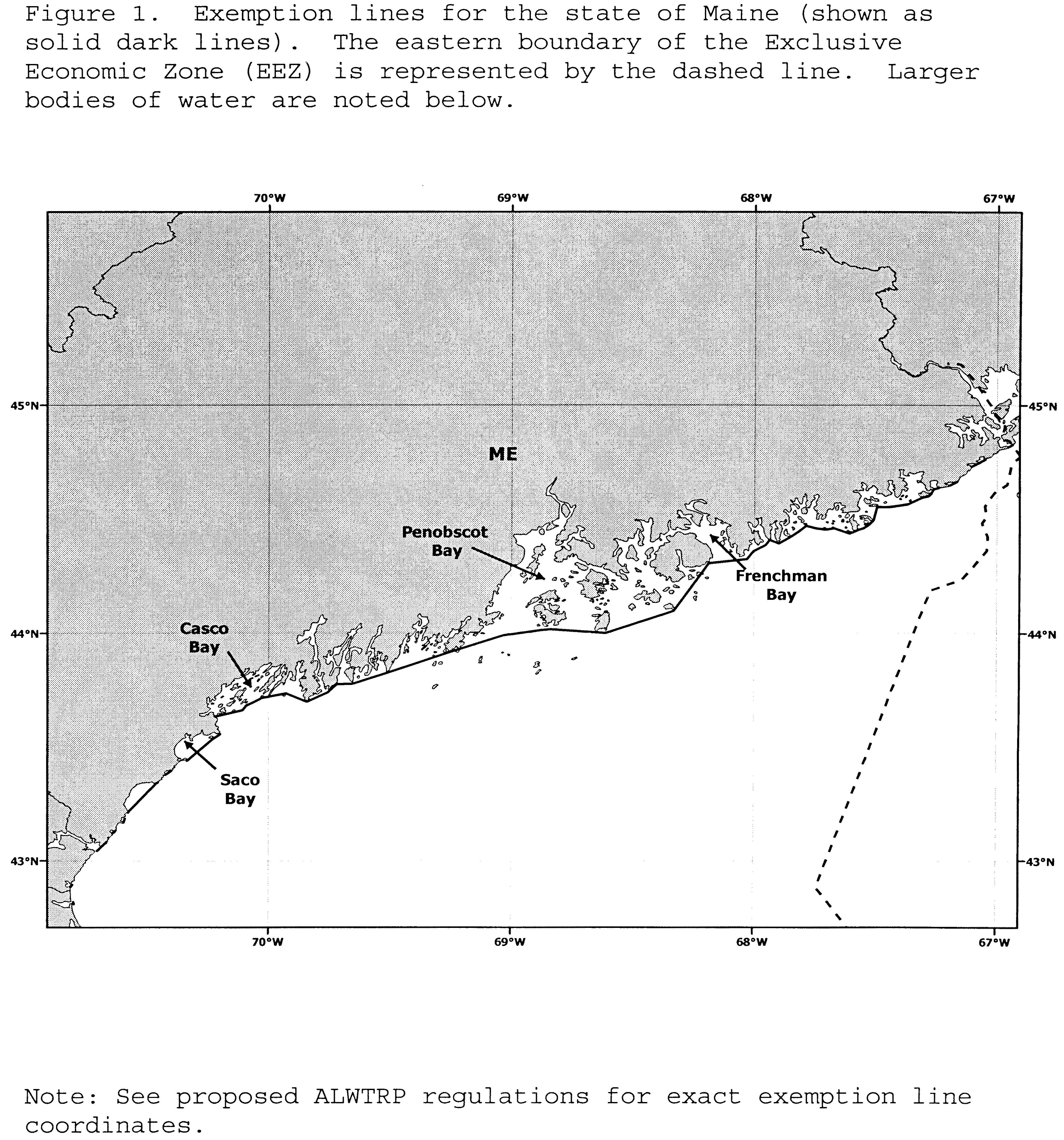
Start Printed Page 35917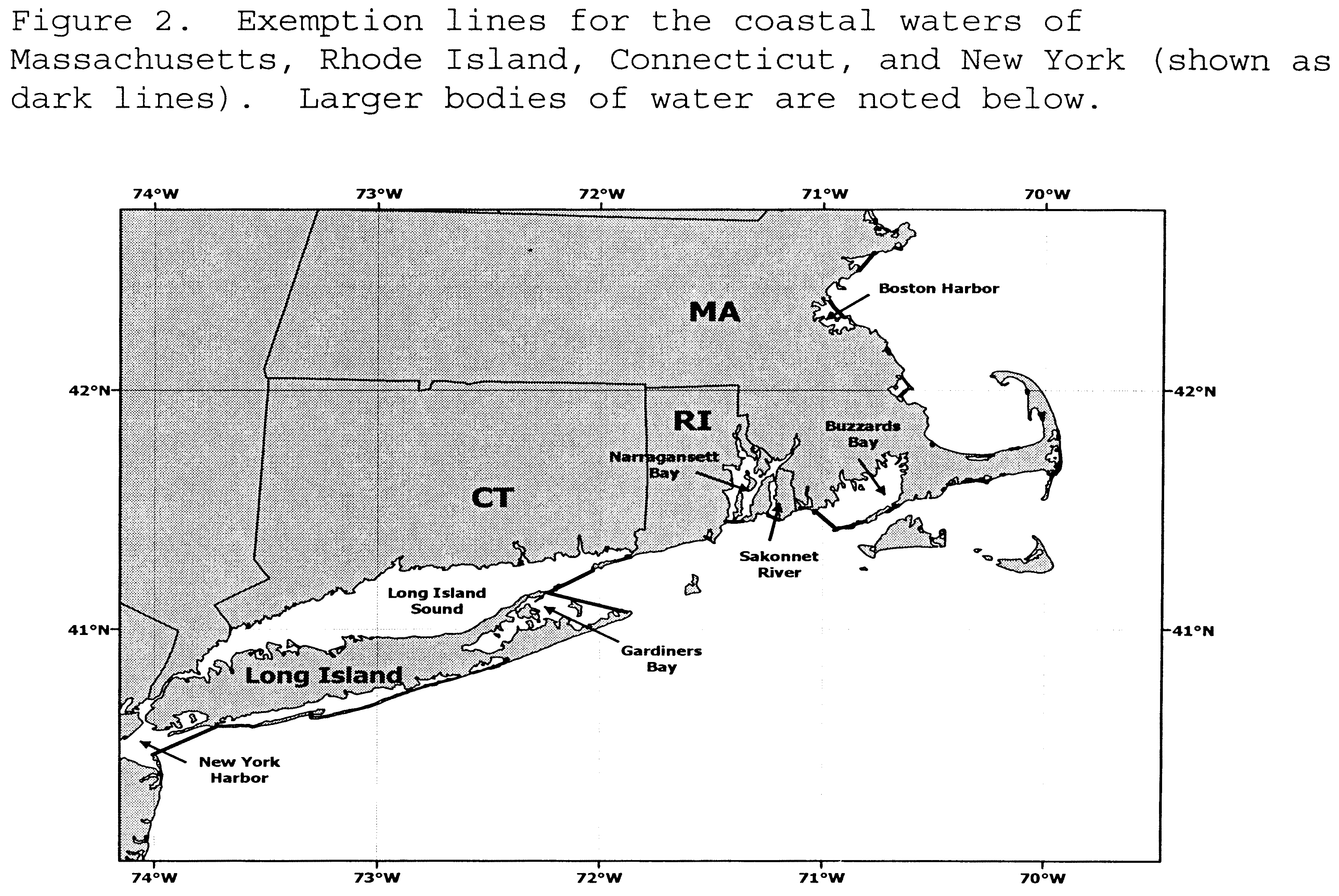
Start Printed Page 35918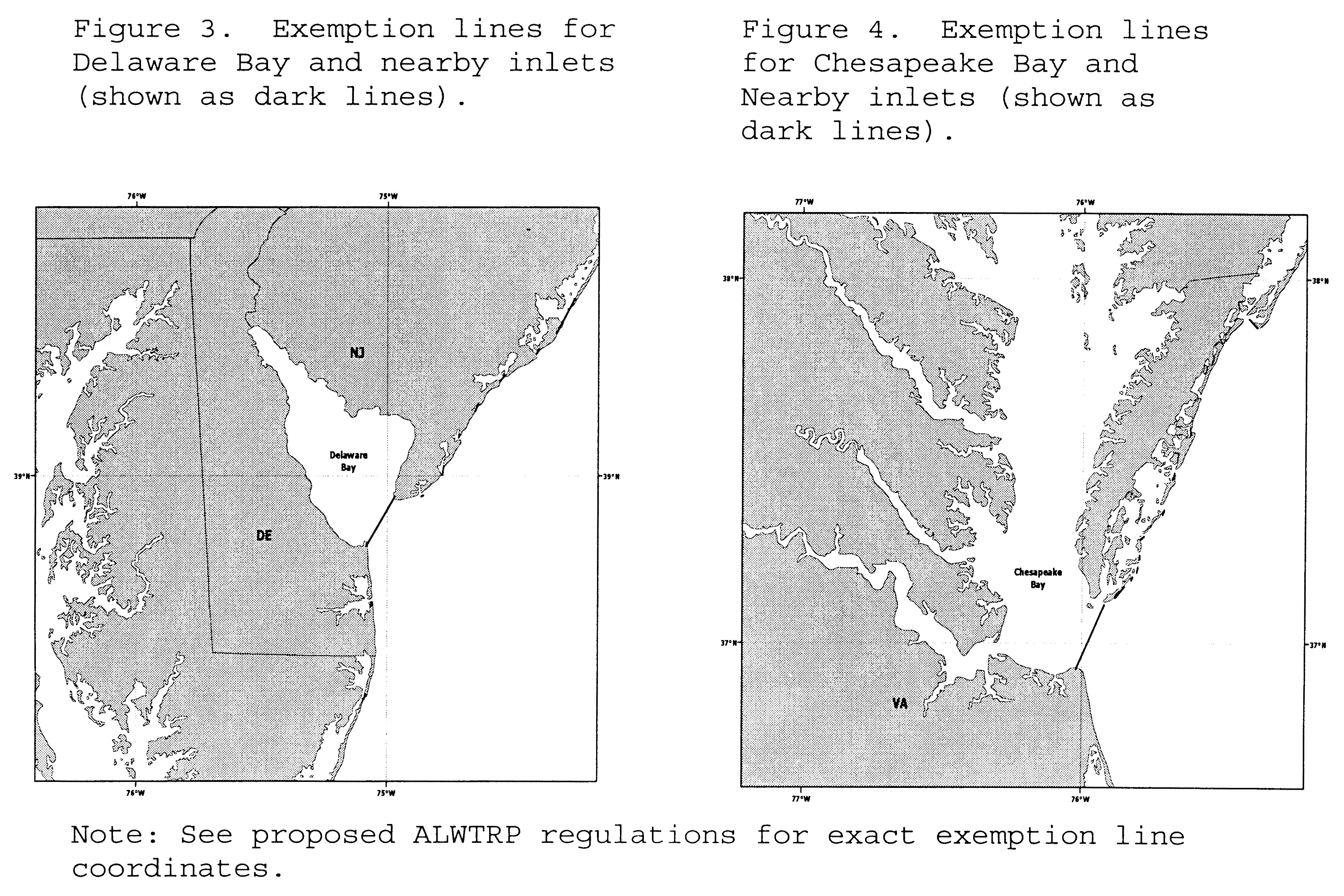
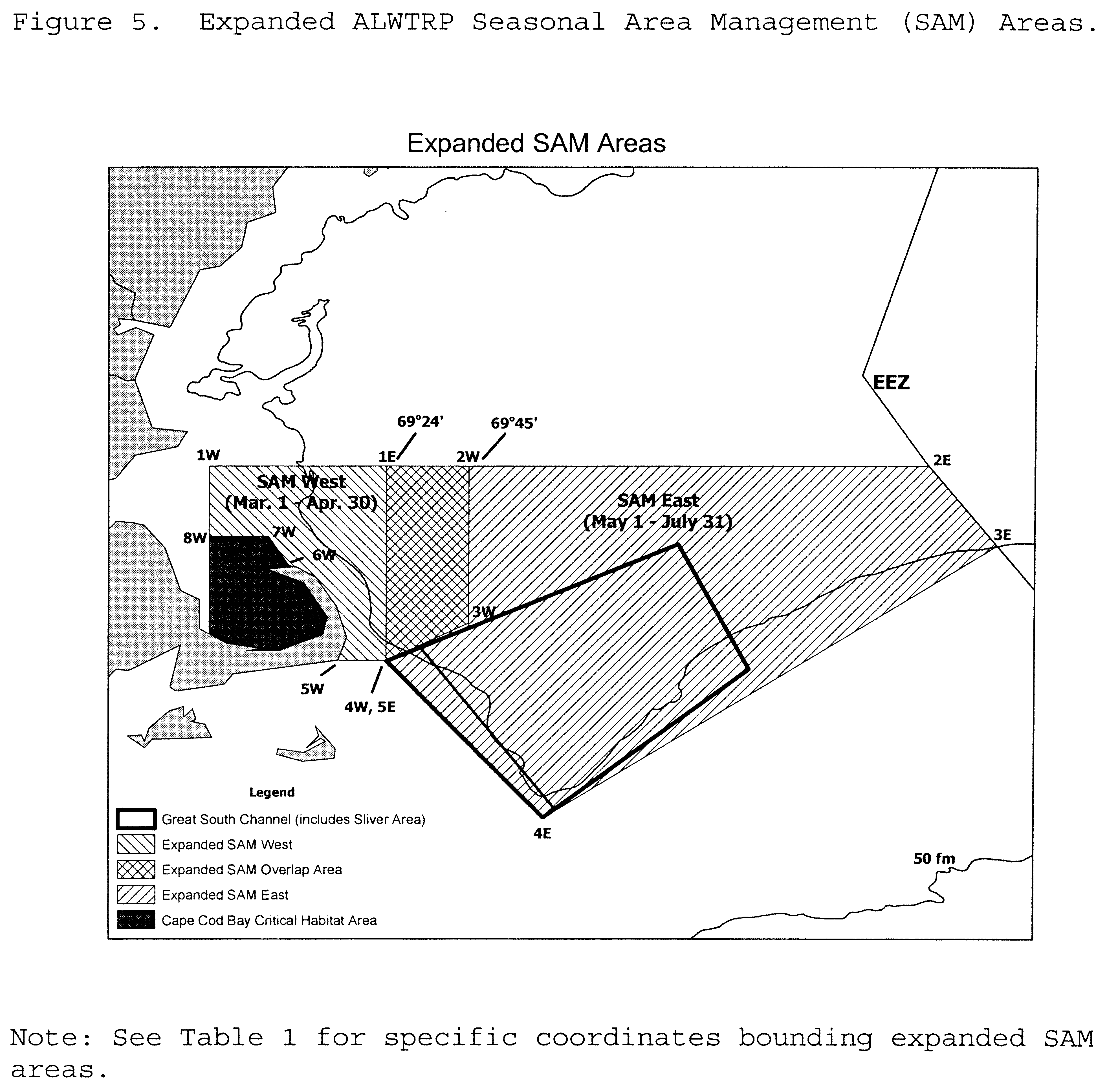
Mate, B.R.; Nieukirk, S.L.; Kraus, S.D. 1997. Satellite-monitored movements of the northern right whale, Journal of Wildlife Management, 61(4).
McKiernan, D.; Pol, M.; Malkoski, V. 2002. A Study of the Underwater Profiles of Lobster Trawl Ground Lines: Report to NMFS in support of the Massachusetts Right Whale Conservation Program, Contract # 50EANF-1-00048.
Merrick, R.L.; Clapham, P.J.; Cole, T.V.N.; Gerrior, P.; Pace, R.M., III. 2001. Identification of seasonal area management zones for North Atlantic right whale conservation. Northeast Fisheries Science Center Reference Document 01-14. October 2001.
NMFS. 2004. Draft Environmental Impact Statement on the Proposed Rule to Amend the Atlantic Large Whale Take Reduction Plan. Northeast Region.
Start List of SubjectsList of Subjects
50 CFR Part 229
- Administrative practice and procedure
- Confidential business information
- Fisheries
- Marine mammals
- Reporting and recordkeeping requirements
50 CFR Part 635
- Fisheries
- Fishing
- Fishing vessels
- Foreign relations
- Imports
- Penalties
- Reporting and recordkeeping requirements
- Treaties
50 CFR Part 648
- Fisheries
- Fishing
- Reporting and recordkeeping requirements
End SignatureDated: May 19, 2005.
Rebecca Lent,
Deputy Assistant Administrator for Regulatory Programs, National Marine Fisheries Service.
For the reasons set out in the preamble, 50 CFR part 229, 50 CFR part 635 and 50 CFR part 648 are proposed to be amended as follows to implement Alternative 3 (Preferred):
Start PartPART 229—AUTHORIZATION FOR COMMERCIAL FISHERIES UNDER THE MARINE MAMMAL PROTECTION ACT OF 1972
1. The authority citation for 50 CFR part 229 continues to read as follows:
Start Printed Page 359192. In § 229.2, the definitions of “Lobster trap” and “Lobster trap trawl” are removed. The definitions of “Anchored gillnet”, “Gillnet”, “Groundline”, “Shark gillnet or shark gillnetting”, and “Strikenet or to fish with strikenet gear” are revised in alphabetical order to read as follows below. The definitions of “Bitter end”, “Bottom portion of line”, “Neutrally buoyant line”, “Sinking line”, “Straight set or to fish with gillnet gear in a straight set”, “Sunrise”, “Sunset”, “Trap/Pot”, and “Trap trawl” are added in alphabetical order to read as follows:
Definitions.* * * * *Anchored gillnet means any gillnet gear, including an anchored float gillnet, sink gillnet, or stab net, that is set anywhere in the water column and which is anchored, secured, or weighted to the bottom of the sea. Also called a set gillnet.
* * * * *Bitter end means the loose end of a line that has detached from a weak link.
* * * * *Bottom portion of the line means, for buoy lines, the portion of the line in the water column that is closest to the fishing gear.
* * * * *Gillnet means fishing gear consisting of a wall of webbing (meshes) or nets, designed or configured so that the webbing (meshes) or nets are placed in the water column, usually held approximately vertically, and are designed to capture fish by entanglement, gilling, or wedging. The term “gillnet” includes gillnets of all types, including but not limited to sink gillnets, other anchored gillnets (e.g., anchored float gillnets, stab, and set nets), and drift gillnets. Gillnets may or may not be attached to a vessel.
Groundline, with reference to trap/pot gear, means a line connecting traps in a trap trawl, and, with reference to gillnet gear, means a line connecting a gillnet or gillnet bridle to an anchor or buoy line.
* * * * *Neutrally buoyant line means, for both groundlines and buoy lines, line that has a specific gravity of 1.030 or greater, and, for groundlines only, does not float at any point in the water column (See also Sinking line).
* * * * *Shark gillnet or shark gillnetting means a gillnet with webbing of 5 inches or greater stretched mesh that is fished in the waters south of the South Carolina/Georgia border, or to fish with such a gillnet in those waters.
* * * * *Sinking line means, for both groundlines and buoy lines, line that has a specific gravity of 1.030 or greater, and, for groundlines only, does not float at any point in the water column (See also Neutrally buoyant line).
* * * * *Straight set or to fish with gillnet gear in a straight set means a set in which the gillnet is placed in a line in the water column, as opposed to a circular set in which the gillnet is placed to encircle an area in the water column (not Strikenet).
* * * * *Strikenet or to fish with strikenet gear means a method or technique of net deployment which is intended to encircle or enclose an area of water either with the net or by utilizing the shoreline to complete the encirclement (not Straight set).
Sunrise means the time of sunrise as determined for the date and location in The Nautical Almanac, prepared by the U.S. Naval Observatory.
* * * * *Sunset means the time of sunset as determined for the date and location in The Nautical Almanac, prepared by the U.S. Naval Observatory.
* * * * *Trap/Pot means any structure or other device, other than a net or longline, that is placed, or designed to be placed, on the ocean bottom and is designed for or is capable of, catching lobster, crab (red, Jonah, rock, and blue), hagfish, finfish (black sea bass, scup, tautog, cod, haddock, pollock, redfish (ocean perch), and white hake), conch/whelk, and shrimp.
Trap trawl means two or more trap/pots attached to a single groundline.
* * * * *3. In § 229.3, paragraphs (h) through (l) are revised to read as follows:
Prohibitions.* * * * *(h) It is prohibited to fish with or have available for immediate use trap/pot gear in the areas and for the times specified in § 229.32(b)(2) and (c)(2) through (c)(8) unless the trap/pot gear complies with the closures, marking requirements, modifications, and restrictions specified in § 229.32(b)(3)(i), (b)(3)(ii), and (c)(1) through (c)(9).
(i) It is prohibited to fish with or have available for immediate use anchored gillnet gear in the areas and for the times specified in § 229.32(b)(2) and (d)(2) through (d)(7) unless that gillnet gear complies with the closures, marking requirements, modifications, and restrictions specified in § 229.32(b)(3)(i), (b)(3)(ii), and (d)(1) through (d)(8).
(j) It is prohibited to fish with or have available for immediate use drift gillnet gear in the areas and for the times specified in § 229.32(d)(7) and (e)(1) unless the drift gillnet gear complies with the restrictions specified in § 229.32(e)(1).
(k) It is prohibited to fish with or have available for immediate use southeast Atlantic gillnet gear in the areas and for the times specified in § 229.32(f)(1)(i) unless the gillnet gear complies with the requirements specified in § 229.32(f)(1)(ii) and (f)(1)(iii).
(l) It is prohibited to fish with or have available for immediate use shark gillnet gear in the areas and for the times specified in § 229.32(b)(2), (g)(1)(i), and (g)(1)(ii) unless the gear complies with the closures, marking requirements, modifications, and restrictions specified in § 229.32(b)(3)(i), (b)(3)(ii), and (g)(2) through (g)(3)(iii)(D).
* * * * *4. Section 229.32 is revised to read as follows:
End Part Start PartAtlantic large whale take reduction plan regulations.(a)(1) Purpose and scope. The purpose of this section is to implement the Atlantic Large Whale Take Reduction Plan to reduce incidental bycatch of fin, humpback, and right whales in specific commercial fisheries from Maine to Florida. The gear types affected by this plan include anchored gillnets, traps/pots, drift gillnets, and shark gillnets (including strikenets).
(2) Regulated waters. The regulations in this section apply to all U.S. waters except for the areas exempted in paragraphs (a)(3) and (a)(4) of this section.
(3) Exempted waters. (i) The regulations in this section do not apply to waters landward of the 72 COLREGS demarcation lines (International Regulations for Preventing Collisions at Sea, 1972), as depicted or noted on nautical charts published by the National Oceanic and Atmospheric Administration (Coast Charts 1:80,000 scale), and as described in 33 CFR Part 80 with the exception of the waters landward of the following lines:
42°20.665′ N., 70°57.205′ W. TO 42°20.009′ N., 70°55.803′ W. and
42°19.548′ N., 70°55.436′ W. TO 42°18.599′ N., 70°52.961′ W. (Boston Harbor).
41°11.40′ N., 72°09.70′ W. TO 41°04.50′ N., 71°51.60′ W. (Gardiners Bay).
Start Printed Page 35920(ii) Other exempted waters. Where the 72 COLREGS demarcation lines do not exist, the regulations in this section do not apply to the waters landward of the Territorial sea baseline, where appropriate, in Maine (as depicted or noted on nautical charts published by the National Oceanic and Atmospheric Administration (Coast Charts 1:80,000 scale), and as described in 33 CFR 2.20) or landward of the following lines:
Maine
44°49.863′ N., 66°55.664′ W. TO 44°48.924′ N., 66°57.01′ W. (Quoddy Narrows, U.S./Canada border)
44°45.682′ N., 67°02.936′ W. TO 44°44.696′ N., 67°04.374′ W. (Baileys Mistake and Haycock Harbor)
44°44.446′ N., 67°04.858′ W. TO 44°43.843′ N., 67°05.909′ W. (Moose Cove)
Territorial Sea Baseline (Little River)
A line connecting the points (Little Machias Bay, Cross Island Narrows, Machias Bay, Englishman Bay, Chandler Bay, and Eastern
Bay):
44°38.14′ N., 67°13.788′ W. (Great Head)
44°37.679′ N., 67°15.424′ W. (Cape Wash)
44°36.659′ N., 67°16.205′ W. (Scotch Island)
44°36.236′ N., 67°16.857′ W. (Spruce Point)
44°35.071′ N., 67°21.177′ W. (Libby Islands)
44°33.369′ N., 67°29.787′ W. (Great Spruce Island)
44°31.908′ N., 67°31.842′ W. (Mark Island)
44°30.637′ N., 67°31.431′ W. (Head Harbor Island)
A line connecting the points (Eastern Bay):
44°29.521′ N., 67°30.935′ W. (Black Head)
44°28.50′ N., 67°31.878′ W. (Moose Peak)
44°27.332′ N., 67°34.15′ W. (Little Pond Head)
A line connecting the points (Moosabec Reach and Wahoa Bay):
44°29.945′ N. 67°36.228′ W. (The Flying Place)
44°30.196′ N. 67°36.832′ W. (Beals Island)
44°30.334′ N. 67°38.573′ W. (Norton Island)
44°29.729′ N. 67°42.609′ W. (Tibbett Island)
44°29.824′ N. 67°44.107′ W. (Cape Split)
Territorial Sea Baseline (Pleasant Bay, Narraguagus Bay, and Pigeon Hill Bay)
A line connecting the points (Dyer Bay, Gouldsboro Bay, Prospect Harbor, and Schoodic Harbor):
44°23.69′ N., 67°53.951′ W. (Petit Manan Point)
44°23.113′ N., 67°58.853′ W. (Cranberry Point)
44°21.416′ N., 68°01.556′ W. (Spruce Point)
44°20.131′ N., 68°02.782′ W. (Schoodic Head)
Territorial Sea Baseline (Frenchman Bay)
A line connecting the points (Blue Hill Bay and Penobscot Bay):
44°18.431′ N., 68°11.337′ W. (Otter Point, Mount Desert Island)
44°14.504′ N., 68°11.040′ W. (Baker's Island)
44°06.00′ N., 68°20.07′ W. (Rich's Head, Long Island)
43°59.36′ N., 68°37.95′ W. (Roaring Bull Ledge, Isle au Haut)
43°59.83′ N., 68°50.06′ W. (South Vinalhaven Island)
43°56.72′ N., 69°04.89′ W. (Two Bush Channel)
43°54.903′ N., 69°13.175′ W. (Mosquito Island)
43°55.074′ N., 69°15.579′ W. (Marshall Point, Port Clyde)
Territorial Sea Baseline (Johns Bay and Muscongus Bay)
A line connecting the points (Sheepscot Bay and Booth Bay):
43°48.872′ N., 69°35.465′ W. (Linekin Neck)
43°48.206′ N., 69°35.913′ W. (Ram Island)
43°47.233′ N., 69°39.209′ W. (Cape Newagen)
43°47.168′ N., 69°39.621′ W. (Cape Newagen)
43°46.947′ N., 69°43.097′ W. (Outer Head)
43°44.658′ N., 69°45.288′ W. (Salter Island)
43°42.056′ N., 69°50.185′ W. (Small Point, Cape Small)
43°42.298′ N., 69°51.23′ W. (Bald Head, Cape Small)
Territorial Sea Baseline (Saco Bay)
43°23.963′ N., 70°23.882′ W. TO 43°22.401′ N., 70°25.296′ W. (Goosefare Bay)
43°22.198′ N., 70°25.065′ W. TO 43°21.823′ N., 70°24.977′ W. (Stage Island Harbor)
43°21.663′ N., 70°24.977′ W. TO 43°13.267′ N., 70°34.542′ W. (body of water between Cape Porpoise and Bald Head Cliff)
43°11.176′ N., 70°35.867′ W. TO 43°10.984′ N., 70°36.161′ W. (Cape Neddick Harbor)
43°08.115′ N., 70°37.434′ W. TO 43°07.56′ N., 70°38.049′ W. (York Harbor)
43°06.104′ N., 70°39.037′ W. TO 43°05.574′ N., 70°39.369′ W. (Brave Boat Harbor)
New Hampshire
42°53.691′ N., 70°48.516′ W. TO 42°53.516′ N., 70°48.748′ W. (Hampton Harbor)
42°59.986′ N., 70°44.654′ W. TO 42°59.956′ N., 70°44.737′ W. (Rye Harbor)
Massachusetts
42°49.136′ N., 70°48.242′ W. TO 42°48.964′ N., 70°48.282′ W. (Newburyport Harbor)
42°42.145 N., 70°46.995′ W. TO 42°41.523′ N., 70°47.356′ W. (Plum Island Sound)
42°40.266′ N., 70°43.838′ W. TO 42°39.778′ N., 70°43.142′ W. (Essex Bay)
42°39.645′ N., 70°36.715′ W. TO 42°39.613′ N., 70°36.60′ W. (Rockport Harbor)
42°15.203′ N., 70°46.324′ W. TO 42°15.214′ N., 70°47.352′ W. (Cohasset Harbor)
42°12.09′ N., 70°42.98′ W. TO 42°12.211′ N., 70°43.002 W. (Scituate Harbor)
42°09.724′ N., 70°42.378′ W. TO 42°10.085′ N., 70°42.875′ W. (New Inlet)
42°04.64′ N., 70°38.587′ W. TO 42°04.583′ N., 70°38.631′ W. (Green Harbor)
41°59.686′ N., 70°37.948′ W. TO 41°58.75′ N., 70°39.052′ W. (Duxbury Bay/Plymouth Harbor)
41°50.395′ N., 70°31.943′ W. TO 41°50.369′ N., 70°32.145′ W. (Ellisville Harbor)
41°45.53′ N., 70°09.387′ W. TO 41°45.523′ N., 70°09.307′ W. (Sesuit Harbor)
41°45.546′ N., 70°07.39′ W. TO 41°45.551′ N., 70°07.32′ W. (Quivett Creek)
41°47.269′ N., 70°01.411′ W. TO 41°47.418′ N., 70°01.306′ W. (Namskaket Creek)
41°47.961′ N., 70°0.561′ W. TO 41°48.07′ N., 70°0.514′ W. (Rock Harbor Creek)
41°48.932′ N., 70°0.286′ W. TO 41°48.483′ N., 70°0.216′ W. (Boat Meadow River)
41°48.777′ N., 70°0.317′ W. TO 41°48.983′ N., 70°0.196′ W. (Herring River)
41°53.922′ N., 70°01.333′ W. TO 41°54.497′ N., 70°01.182′ W. (Blackfish Creek/Loagy Bay)
41°55.503′ N., 70°02.07′ W. TO 41°55.753′ N., 70°02.281′ W. (Duck Creek)
41°55.501′ N., 70°03.51′ W. TO 41°55.322′ N., 70°03.191′ W. (Herring River, inside Wellfleet Harbor) Start Printed Page 35921
41°59.481′ N., 70°04.779′ W. TO 41°59.563′ N., 70°04.718′ W. (Pamet River)
42°03.601′ N., 70°14.269′ W. TO 42°03.601′ N., 70°14.416′ W. (Hatches Harbor)
41°48.708′ N., 69°56.319′ W. TO 41°48.554′ N., 69°56.238′ W. (Nauset Harbor)
41°40.685′ N., 69°56.781′ W. TO 41°40.884′ N., 69°56.28′ W. (Chatham Harbor)
41°39.429′ N., 69°58.827′ W. TO 41°39.442′ N., 69°59.037′ W. (Stage Harbor)
41°39.80′ N., 70°03.661′ W. TO 41°39.626′ N., 70°03.791′ W. (Wynchmere Harbor/Saquatucket Harbor)
41°39.764′ N., 70°05.324′ W. TO 41°39.666′ N., 70°05.371′ W. (Doanes Creek)
41°39.322′ N., 70°06.914′ W. TO 41°39.30′ N., 70°06.952′ W. (Herring River)
41°39.085′ N., 70°09.401′ W. TO 41°39.087′ N., 70°09.467′ W. (Swan Pond River)
41°38.584′ N., 70°11.724′ W. TO 41°38.643′ N., 70°11.849′ W (Bass River)
41°38.211′ N., 70°13.25′ W. TO 41°38.121′ N., 70°13.247′ W. (Parkers River)
41°36.575′ N., 70°15.95′ W. TO 41°37.452′ N., 70°17.537′ W. (Hyannis Harbor)
41°37.49′ N., 70°21.899′ W. TO 41°37.408′ N., 70°21.846′ W. (East Bay)
41°36.344′ N., 70°24.049′ W. TO 41°36.398′ N., 70°24.09′ W. (West Bay)
41°36.289′ N., 70°25.624′ W TO 41°36.302′ N., 70°26.254′ W. (Cotuit Bay)
41°35.32′ N., 70°27.047′ W. TO 41°35.202′ N., 70°27.041′ W. (Popponesset Bay)
41°32.862′ N., 70°31.614′ W. TO 41°32.804′ N., 70°31.762′ W. (Waquoit Bay)
41°33.086′ N., 70°32.53′ W. TO 41°33.07′ N., 70°32.884′ W. (Eel Pond)
A line formed by the centerline of the fixed bridges at both entrances (Bournes Pond)
41°32.871′ N., 70°34.214′ W. TO 41°32.855′ N., 70°34.252′ W. (Green Pond)
A line formed by the centerline of the fixed bridge at entrance (Great Pond)
41°32.542′ N., 70°36.449′ W. TO 41°32.535′ N., 70°36.505′ W. (Falmouth Inner Harbor)
41°30.597′ N., 71°05.285′ W. TO 41°30.444′ N., 71°05.281′ W. (Westport Harbor)
Rhode Island
41°22.41′ N., 71°30.80′ W. TO 41°22.41′ N., 71°30.85′ W. (Pt. Judith Pond Inlet)
41°21.31′ N., 71°38.30′ W. TO 41°21.30′ N., 71°38.33′ W. (Ninigret Pond Inlet)
41°19.90′ N., 71°43.08′ W. TO 41°19.90′ N., 71°43.10′ W. (Quonochontaug Pond Inlet)
41°19.66′ N., 71°45.75′ W. TO 41°19.66′ N., 71°45.78′ W. (Weekapaug Pond Inlet)
South Carolina
32°34.717′ N., 80°08.565′ W. TO 32°34.686′ N., 80°08.642′ W. (Captain Sams Inlet)
(4) Sinking and/or neutrally buoyant groundline exemption. The fisheries regulated under this section are exempt from the requirement to have groundlines composed of sinking and/or neutrally buoyant line on or before January 1, 2008, if gear is set in waters deeper than 280 fathoms (1,680 ft or 512.1 m).
(b) Gear marking requirements. (1) Specified gear consists of trap/pot gear and gillnet gear set in specified areas.
(2) Specified areas. The following areas are specified for gear marking purposes: Northern Inshore State Trap/Pot Waters, CCB Restricted Area, Stellwagen Bank/Jeffreys Ledge Restricted Area, Northern Nearshore Trap/Pot Waters Area, GSC Restricted Trap/Pot Area, GSC Restricted Gillnet Area, GSC Sliver Restricted Area, Southern Nearshore Trap/Pot Waters Area, Offshore Trap/Pot Waters Area, Other Northeast Gillnet Waters Area, Mid/South Atlantic Gillnet Waters Area, and Other Southeast Gillnet Waters Area.
(3) Requirements for Shark Gillnet Gear in the Northern Monitoring and Restricted Area and Southern Monitoring Area. From November 15 through March 31 of the following year, no person may fish with shark gillnet gear in the Northern Monitoring and Restricted Area and the Southern Monitoring Area unless that gear is marked in accordance with the gear marking codes specified under paragraphs (b)(3)(i)(A) and (b)(3)(i)(B) of this section. All buoy lines that are greater than 4 ft (1.22 m) long must be marked within 2 ft (0.6 m) of the top of the buoy line and midway along the length of the buoy line. Each net panel must be marked along both the float line and the lead line at least once every 100 yards (92.4 m), unless otherwise required by the Assistant Administrator under paragraph (h) of this section.
(i) Color code. Shark gillnet gear in the Northern Monitoring and Restricted Area and Southern Monitoring Area must be marked with the appropriate color code to designate gear types and areas as follows:
(A) Gear type code—Shark gillnet gear. Shark gillnet gear must be marked with a green marking.
(B) Area code. Shark gillnet gear set in the Northern Monitoring and Restricted Area and Southern Monitoring Area must be marked with a blue marking.
(ii) Markings. All shark gillnet gear in the Northern Monitoring and Restricted Area and Southern Monitoring Area must be marked with two color codes noted above, one designating the gear type, the other indicating the area where the gear is set. Each color of the two-color code must be permanently marked on or along the line or lines specified under paragraph (f)(2) of this section. Each color mark of the color codes must be clearly visible when the gear is hauled or removed from the water. Each mark must be at least 4 inches (10.2 cm) long. The two color marks must be placed within 6 inches (15.2 cm) of each other. If the color of the rope is the same as or similar to a color code, a white mark may be substituted for that color code. In marking or affixing the color code, the line may be dyed, painted, or marked with thin colored whipping line, thin colored plastic, or heat-shrink tubing, or other material; or a thin line may be woven into or through the line; or the line may be marked as approved in writing by the Assistant Administrator (AA). (A copy of a brochure illustrating the techniques for marking gear is available upon request to the Office of the Regional Administrator, NMFS, 1 Blackburn Drive, Gloucester, MA 01930.)
(4) Requirements for other specified areas. Any person who owns or fishes with specified gear in the other specified areas must mark that gear in accordance with paragraphs (b)(4)(i) and (b)(4)(ii) of this section, unless otherwise required by the Assistant Administrator under paragraph (h) of this section. For the purposes of the following gear marking requirements only, trap/pot gear set in the Northern Nearshore State Trap/Pot Waters Area, the CCB Restricted Area during the winter restricted period, the Federal-water portion of the CCB Restricted Area during the off-peak period, and the Stellwagen Bank/Jeffreys Ledge Restricted Area shall comply with the requirements for the Northern Nearshore Trap/Pot Waters Area specified in paragraph (b)(4)(i)(A) of this section. Trap/pot gear set in the GSC Restricted Trap/Pot Area shall comply with the requirements for the Offshore Start Printed Page 35922Trap/Pot Waters Area specified in paragraph (b)(4)(i)(C) of this section. Similarly, anchored gillnet gear set in the CCB Restricted area, Stellwagen Bank/Jeffreys Ledge Restricted Area, GSC Restricted Gillnet Area, and GSC Sliver Restricted Area shall comply with the requirements for gillnet gear in the Other Northeast Gillnet Waters Area specified in paragraph (b)(4)(i)(D) of this section.
(i) Color code. Specified gear must be marked with the appropriate colors to designate gear-types and areas as follows:
(A) Trap/pot gear in the Northern Nearshore Trap/Pot Waters Area must be marked with a red marking.
(B) Trap/pot gear in the Southern Nearshore Trap/Pot Waters Area must be marked with an orange marking.
(C) Trap/pot gear in the Offshore Trap/Pot Waters Area must be marked with a black marking.
(D) Gillnet gear in the Other Northeast Gillnet Waters Area must be marked with a green marking.
(E) Gillnet gear in the Mid/South Atlantic Gillnet Waters Area must be marked with a blue marking.
(F) Gillnet gear in the Other Southeast Gillnet Waters Area (except shark gillnet gear) must be marked with a yellow marking.
(ii) Markings. All specified gear in specified areas must be marked with one color code (see paragraph (b)(4)(i) of this section) which indicates the gear type and general area where the gear is set. Each color code must be permanently affixed on or along the line or lines. Each color code must be clearly visible when the gear is hauled or removed from the water. Each mark must be at least 4 inches (10.2 cm) long. The mark must be placed every 10 fathoms (60 ft or 18.3 m) along the buoy line or in the center of the buoy line if it is 10 fathoms (60 ft or 18.3 m) or less. (A copy of a brochure illustrating the techniques for marking gear is available upon request to the Office of the Regional Administrator, NMFS, 1 Blackburn Drive, Gloucester, MA 01930.)
(5) Buoy markings. Trap/pot and gillnet gear regulated under this section must mark all surface buoys to identify the vessel or fishery with one of the following: the owner's motorboat registration number, the owner's U.S. vessel documentation number, the federal commercial fishing permit number, or whatever positive identification marking is required by the vessel's home-port state. The letters and numbers used to mark the gear must be at least 1 inch (2.5 cm) in height in block letters or arabic numbers in a color that contrasts with the background color of the buoy. (A copy of a brochure illustrating the techniques for marking gear is available upon request to the Office of the Regional Administrator, NMFS, 1 Blackburn Drive, Gloucester, MA 01930.)
(6) Changes to requirements. If the Assistant Administrator revises the gear marking requirements in accordance with paragraph (h) of this section, the gear must be marked in compliance with those requirements.
(c) Restrictions applicable to trap/pot gear in regulated waters—(1) Universal trap/pot gear requirements. In addition to the area-specific measures listed in paragraphs (c)(2) through (c)(8) of this section, all trap/pot gear in regulated waters, including the Northern Inshore State Trap/Pot Waters Area, must comply with the universal gear requirements listed here[1] . The Assistant Administrator may revise these requirements in accordance with paragraph (h) of this section.
(i) No buoy line floating at the surface. No person may fish with trap/pot gear that has any portion of the buoy line that is directly connected to the gear at the ocean bottom floating at the surface at any time. If more than one buoy is attached to a single buoy line or if a high flyer and a buoy are used together on a single buoy line, floating line may be used between these objects.
(ii) No wet storage of gear. Trap/pot gear must be hauled out of the water at least once every 30 days.
(2) Cape Cod Bay (CCB) Restricted Area—(i) Area. The CCB restricted area consists of the CCB right whale critical habitat area specified under 50 CFR 226.203(b) unless the Assistant Administrator changes that area in accordance with paragraph (h) of this section.
(ii) Area-specific gear requirements during the winter restricted period. No person may fish with or have available for immediate use trap/pot gear in the CCB Restricted Area during the winter restricted period unless that person's gear complies with the gear marking requirements in paragraph (b) of this section, the universal trap/pot gear requirements in (c)(1) of this section, and the area-specific requirements listed below for the winter restricted period. The Assistant Administrator may revise these requirements in accordance with paragraph (h) of this section.
(A) Winter restricted period. The winter restricted period for the CCB Restricted Area is from January 1 through May 15 of each year unless the Assistant Administrator changes this period in accordance with paragraph (h) of this section.
(B) Weak links. All buoys, flotation devices and/or weights, such as toggles and/or leaded lines, must be attached to the buoy line with a weak link placed as close to each individual buoy, flotation device and/or weight as operationally feasible and that meets the following specifications:
(1) The breaking strength of the weak link must not exceed 500 lb (226.7 kg).
(2) The weak link must be chosen from the following list of combinations approved by NMFS: swivels, plastic weak links, rope of appropriate breaking strength, hog rings, rope stapled to a buoy stick, or other materials or devices approved in writing by the Assistant Administrator. (A copy of a brochure illustrating the techniques for making weak links is available upon request to the Office of the Regional Administrator, NMFS, 1 Blackburn Drive, Gloucester, MA 01930.)
(3) Weak links must break cleanly at the bitter end of the buoy line and the bitter end of the buoy line must be free of any knots when the line breaks. Splices are not considered to be knots for the purposes of this provision.
(C) Single traps and multiple-trap trawls. Single traps and three-trap trawls are prohibited. All traps must be set in either a two-trap string or in a trawl of four or more traps. A two-trap string must have no more than one buoy line.
(D) Buoy lines. All buoy lines must be comprised of sinking and/or neutrally buoyant line except the bottom portion of the line, which may be a section of floating line not to exceed one-third the overall length of the buoy line.
(E) Groundlines. All groundlines must be comprised entirely of sinking and/or neutrally buoyant line. The attachment of buoys, toggles, or other floatation devices to groundlines comprised entirely of sinking and/or neutrally buoyant line is prohibited.
(iii) Area-specific gear requirements during the other restricted period. No person may fish with or have available for immediate use trap/pot gear in the CCB Restricted Area during the other restricted period unless that person's gear complies with the gear marking requirements in paragraph (b) of this section and the universal trap/pot gear requirements in (c)(1) of this section as well as the area-specific requirements listed below for the other restricted period. The Assistant Administrator may revise these requirements in accordance with paragraph (h) of this section. Start Printed Page 35923
(A) Other restricted period. The other restricted period for the CCB Restricted Area is from May 16 through December 31 of each year unless the Assistant Administrator revises this period in accordance with paragraph (h) of this section.
(B) Gear requirements—(1) State-water portion. No person may fish with or have available for immediate use trap/pot gear in the state-water portion of the CCB Restricted Area during the other restricted period unless that person's gear complies with the requirements for the Northern Inshore State Trap/Pot Waters Area listed in (c)(6) of this section. The Assistant Administrator may revise these requirements in accordance with paragraph (h) of this section.
(2) Federal-water portion. No person may fish with or have available for immediate use trap/pot gear in the Federal-water portion of the CCB Restricted Area during the other restricted period unless that person's gear complies with the requirements for the Northern Nearshore Trap/Pot Waters Area in (c)(7) of this section. The Assistant Administrator may revise these requirements in accordance with paragraph (h) of this section.
(3) Great South Channel (GSC) Restricted Trap/Pot Area—
(i) Area. The GSC Restricted Area consists of the GSC right whale critical habitat area specified under 50 CFR 226.203(a) unless the Assistant Administrator changes that area in accordance with paragraph (h) of this section.
(ii) Closure during the spring restricted period—The spring restricted period for the GSC Restricted Trap/Pot Area is from April 1 through June 30 of each year unless the Assistant Administrator revises this period in accordance with paragraph (h) of this section. During the spring restricted period, no person may fish with, set, or have available for immediate use trap/pot gear in this Area unless the Assistant Administrator specifies gear modifications or alternative fishing practices in accordance with paragraph (h) of this section and the gear or practices comply with those specifications.
(iii) Area-specific gear requirements for the other restricted period. The other restricted period for the GSC Restricted Trap/Pot Area is July 1 through March 31, unless the Assistant Administrator revises this period in accordance with paragraph (h) of this section. During the other restricted period, no person may fish with or have available for immediate use trap/pot gear in the GSC Restricted Trap/Pot Area unless that person's gear complies with the gear marking requirements in paragraph (b) of this section, the universal trap/pot gear requirements in (c)(1) of this section, and the area-specific requirements listed in paragraph (c)(5)(ii)(A) of this section for the Offshore Trap/Pot Waters Area or paragraph (c)(7)(ii)(A) of this section for the Northern Nearshore Lobster Waters Area, depending on the area of overlap. The Assistant Administrator may revise these requirements in accordance with paragraph (h) of this section.
(4) Stellwagen Bank/Jeffreys Ledge Restricted Area—(i) Area. The Stellwagen Bank/Jeffreys Ledge Restricted Area includes all Federal waters of the Gulf of Maine, except those designated as right whale critical habitat under 50 CFR 226.203(b), that lie south of 43°15′ N. and west of 70°00′ W. The Assistant Administrator may change that area in accordance with paragraph (h) of this section.
(ii) Area-specific gear requirements. No person may fish with or have available for immediate use trap/pot gear in the Stellwagen Bank/Jeffreys Ledge Restricted Area unless that person's gear complies with the gear marking requirements in paragraph (b) of this section, the universal trap/pot gear requirements in (c)(1) of this section, and the requirements listed for the Northern Nearshore Trap/Pot Waters Area in (c)(7) of this section. The Assistant Administrator may revise these requirements in accordance with paragraph (h) of this section.
(5) Offshore Trap/Pot [2] Waters Area—(i) Area. The Offshore Trap/Pot Waters Area includes all Federal waters of the EEZ Offshore Management Area 3 (including the area known as the Area 2/3 Overlap in the American Lobster Fishery regulations at 50 CFR 697.18 and the GSC Restricted Trap/Pot Area from July 1 through March 31) as defined in the American Lobster Fishery regulations at 50 CFR 697.18 and extending south along the 100 fathom (600 ft or 182.9 m) line from 35°30′ N. to 27°51′ N. and then out to the eastern boundary of the EEZ. From November 15 to April 15, the Offshore Trap/Pot Waters Area includes the area from the South Carolina/Georgia border south to 29°00′ N. and then out to the eastern boundary of the EEZ.
(ii) Year-round area-specific gear requirements. No person may fish with or have available for immediate use trap/pot gear in the Offshore Trap/Pot Waters Area unless that person's gear complies with the gear marking requirements in paragraph (b) of this section, the universal trap/pot gear requirements in (c)(1) of this section, and the gear requirements listed here. The Assistant Administrator may revise these requirements in accordance with paragraph (h) of this section.
(A) Weak links. All buoys, flotation devices, and/or weights, such as toggles and/or leaded lines must be attached to the buoy line with a weak link placed as close to each individual buoy, flotation device, and/or weight as operationally feasible and that meets the following specifications:
(1) The weak link must be chosen from the following list of combinations approved by NMFS: Swivels, plastic weak links, rope of appropriate breaking strength, hog rings, rope stapled to a buoy stick, or other materials or devices approved in writing by the Assistant Administrator. (A copy of a brochure illustrating the techniques for making weak links is available upon request to the Office of the Regional Administrator, NMFS, 1 Blackburn Drive, Gloucester, MA 01930.)
(2) The breaking strength of the weak links may not exceed 1,500 lb (680.4 kg).
(3) Weak links must break cleanly at the bitter end of the buoy line and the bitter end of the buoy line must be free of any knots when the line breaks. Splices are not considered to be knots for the purposes of this provision.
(B) Groundline. On or before January 1, 2008, all groundlines must be comprised entirely of sinking and/or neutrally buoyant line unless exempted from this requirement under paragraph (a)(4) of this section. The attachment of buoys, toggles, or other flotation devices to groundlines comprised entirely of sinking and/or neutrally buoyant line is prohibited.
(iii) Seasonal area-specific gear requirements. From November 15 to April 15, no person may fish with or have available for immediate use trap/pot gear from the South Carolina/Georgia border to 29°00′ N. unless that person's gear complies with the gear marking requirements in paragraph (b) of this section, the universal trap/pot gear requirements in paragraph (c)(1) of this section, and the area-specific gear requirements in paragraphs (c)(5)(ii)(A) and (B) of this section. The Assistant Administrator may revise this period and these requirements in accordance with paragraph (h) of this section.
(iv) Seasonal area-specific gear requirements. From December 1 to March 31, no person may fish with or have available for immediate use trap/pot gear from 29°00′ N. to 27°51′ N. Start Printed Page 35924unless that person's gear complies with the gear marking requirements in paragraph (b) of this section, the universal trap/pot gear requirements in (c)(1) of this section, and the area-specific gear requirements in paragraphs (c)(5)(ii)(A) and (B) of this section. The Assistant Administrator may revise this time period and these requirements in accordance with paragraph (h) of this section.
(6) Northern Inshore State Trap/Pot Waters Area—(i) Area. The Northern Inshore State Trap/Pot Waters Area includes the state waters of Rhode Island, Massachusetts, New Hampshire, and Maine but does not include waters exempted under (a)(3) of this section.
(ii) Area-specific gear requirements. No person may fish with or have available for immediate use trap/pot gear in the Northern Inshore State Trap/Pot Waters Area unless that person's gear complies with the gear marking requirements in paragraph (b) of this section, the universal trap/pot gear requirements in (c)(1) of this section, and the gear requirements listed here. The Assistant Administrator may revise this requirement in accordance with paragraph (h) of this section.
(A) Weak links. All buoys, flotation devices, and/or weights, such as toggles and/or leaded lines must be attached to the buoy line with a weak link placed as close to each individual buoy, flotation device, and/or weight as operationally feasible and that meets the following specifications:
(1) The weak link must be chosen from the following list of combinations approved by NMFS: Swivels, plastic weak links, rope of appropriate breaking strength, hog rings, rope stapled to a buoy stick, or other materials or devices approved in writing by the Assistant Administrator. (A copy of a brochure illustrating the techniques for making weak links is available upon request to the Office of the Regional Administrator, NMFS, 1 Blackburn Drive, Gloucester, MA 01930.)
(2) The breaking strength of the weak links may not exceed 600 lb (272.4 kg).
(3) Weak links must break cleanly at the bitter end of the buoy line and the bitter end of the buoy line must be free of any knots when the line breaks. Splices are not considered to be knots for the purposes of this provision.
(B) Groundlines. On or before January 1, 2008, all groundlines must be comprised entirely of sinking and/or neutrally buoyant line. The attachment of buoys, toggles, or other floatation devices to groundlines comprised entirely of sinking and/or neutrally buoyant line is prohibited.
(7) Northern Nearshore Trap/Pot Waters Area—(i) Area. The Northern Nearshore Trap/Pot Waters Area includes all Federal waters of EEZ Nearshore Management Area 1, Area 2, and the Outer Cape Lobster Management Area as defined in the American Lobster Fishery regulations at 50 CFR 697.18, with the exception of the CCB Restricted Area and the Stellwagen Bank/Jeffreys Ledge Restricted Area. The Assistant Administrator may change this area in accordance with paragraph (h) of this section.
(ii) Area-specific gear requirements. No person may fish with or have available for immediate use trap/pot gear in the Northern Nearshore Trap/Pot Waters Area unless that person's gear complies with the gear marking requirements in paragraph (b) of this section, the universal trap/pot gear requirements in (c)(1) of this section, and the gear requirements listed below for this area. The Assistant Administrator may revise these requirements in accordance with paragraph (h) of this section.
(A) Weak Links. All buoys, flotation devices, and/or weights, such as toggles and/or leaded lines, must be attached to the buoy line with a weak link placed as close to each individual buoy, flotation device and/or weight as operationally feasible and that meets the following specifications:
(1) The weak link must be chosen from the following list of combinations approved by NMFS: Swivels, plastic weak links, rope of appropriate breaking strength, hog rings, rope stapled to a buoy stick, or other materials or devices approved in writing by the Assistant Administrator. (A copy of a brochure illustrating the techniques for making weak links is available upon request to the Office of the Regional Administrator, NMFS, 1 Blackburn Drive, Gloucester, MA 01930.)
(2) The breaking strength of the weak links must not exceed 600 lb (272.4 kg).
(3) Weak links must break cleanly at the bitter end of the buoy line and the bitter end of the buoy line must be free of any knots when the line breaks. Splices are not considered to be knots for the purposes of this provision.
(B) Single traps and multiple-trap trawls. Single traps are prohibited. All traps must be set in trawls of two or more traps. All trawls up to and including four traps must have no more than one buoy line.
(C) Groundlines. On or before January 1, 2008, all groundlines must be comprised entirely of sinking and/or neutrally buoyant line. The attachment of buoys, toggles, or other floatation devices to groundlines comprised entirely of sinking and/or neutrally buoyant line is prohibited.
(8) Southern Nearshore Trap/Pot Waters Area—(i) Area. The Southern Nearshore Trap/Pot Waters Area includes all state and Federal waters which fall within EEZ Nearshore Management Area 4, EEZ Nearshore Management Area 5, and EEZ Nearshore Management Area 6 (except for those waters exempted under paragraph (a)(3) of this section) as described in the American Lobster Fishery regulations in 50 CFR 697.18. The Assistant Administrator may change this area in accordance with paragraph (h) of this section.
(ii) Area-specific gear requirements for the restricted period—(A) Restricted period. The restricted period for Southern Nearshore Trap/Pot Waters is year round unless the Assistant Administrator revises this period in accordance with paragraph (h) of this section.
(B) Gear requirements. No person may fish with or have available for immediate use trap/pot gear in the Southern Nearshore Trap/Pot Waters Area during the restricted period unless that person's gear complies with the gear marking requirements specified in paragraph (b) of this section, the universal trap/pot gear requirements in paragraph (c)(1) of this section, and the following gear requirements for this area, which the Assistant Administrator may revise in accordance with paragraph (h) of this section:
(1) Weak Links. All buoys, flotation devices, and/or weights, such as toggles and/or leaded lines, must be attached to the buoy line with a weak link placed as close to each individual buoy, flotation device and/or weight as operationally feasible and that meets the following specifications:
(i) The weak link must be chosen from the following list of combinations approved by NMFS: swivels, plastic weak links, rope of appropriate breaking strength, hog rings, rope stapled to a buoy stick, or other materials or devices approved in writing by the Assistant Administrator. (A copy of a brochure illustrating the techniques for making weak links is available upon request to the Office of the Regional Administrator, NMFS, 1 Blackburn Drive, Gloucester, MA 01930.)
(ii) The breaking strength of the weak links may not exceed 600 lb (272.4 kg).
(iii) Weak links must break cleanly at the bitter end of the buoy line and the bitter end of the buoy line must be free of any knots when the line breaks. Splices are not considered to be knots for the purpose of this provision. Start Printed Page 35925
(2) Groundlines. On or before January 1, 2008, all groundlines must be comprised entirely of sinking and/or neutrally buoyant line. The attachment of buoys, toggles, or other floatation devices to groundlines comprised entirely of sinking and/or neutrally buoyant line is prohibited.
(9) Restrictions applicable to the red crab trap/pot fishery—(i) Area. The red crab trap/pot fishery is regulated in the waters identified in paragraphs (c)(5)(i) and (c)(8)(i) of this section.
(ii) Area-specific gear requirements. No person may fish with or have available for immediate use red crab trap/pot gear in the area identified in paragraph (c)(9)(i) of this section unless that person's gear complies with the gear marking requirements in (c)(1) of this section, the universal trap/pot gear requirements in (c)(1) of this section, and the gear requirements listed here. The Assistant Administrator revises these requirements in accordance with paragraph (h) of this section.
(A) Weak links. All buoys, flotation devices, and/or weights, such as toggles and/or leaded lines must be attached to the buoy line with a weak link placed as close to each individual buoy, flotation device, and/or weight as operationally feasible and that meets the following specifications:
(1) The weak link must be chosen from the following list of combinations approved by NMFS: swivels, plastic weak links, rope of appropriate breaking strength, hog rings, rope stapled to a buoy stick, or other materials or devices approved in writing by the Assistant Administrator. (A copy of a brochure illustrating the techniques for making weak links is available upon request to the Office of the Regional Administrator, NMFS, 1 Blackburn Drive, Gloucester, MA 01930.)
(2) The breaking strength of the weak links may not exceed 2,000 lb (907.2 kg).
(3) Weak links must break cleanly at the bitter end of the buoy line and the bitter end of the buoy line must be free of any knots when the line breaks. Splices are not considered to be knots for the purposes of this provision.
(B) Groundlines. On or before January 1, 2008, all groundlines must be comprised entirely of sinking and/or neutrally buoyant line unless exempted from this requirement under paragraph (a)(4) of this section. The attachment of buoys, toggles, or other floatation devices to groundlines comprised entirely of sinking and/or neutrally buoyant line is prohibited.
(d) Restrictions applicable to anchored gillnet gear—(1) Universal anchored gillnet gear requirements. In addition to the area-specific measures listed in paragraphs (d)(2) through (d)(7) of this section, all anchored gillnet gear in regulated waters must comply with the universal gear requirements listed here [3] . The Assistant Administrator may revise these requirements in accordance with paragraph (h) of this section.
(i) No buoy line floating at the surface. No person may fish with anchored gillnet gear that has any portion of the buoy line that is directly connected to the gear on the ocean bottom floating at the surface at any time. If more than one buoy is attached to a single buoy line or if a high flyer and a buoy are used together on a single buoy line, sinking and/or neutrally buoyant line must be used between these objects.
(ii) No wet storage of gear. Anchored gillnet gear must be hauled out of the water at least once every 30 days.
(2) Cape Cod Bay Restricted Area—(i) Area. The CCB Restricted Area consists of the CCB right whale critical habitat area specified under 50 CFR 226.203(b), unless the Assistant Administrator changes that area in accordance with paragraph (h) of this section.
(ii) Closure during the winter restricted period—(A) Winter restricted period. The winter restricted period for this area is from January 1 through May 15 of each year, unless the Assistant Administrator changes this period in accordance with paragraph (h) of this section.
(B) Closure. During the winter restricted period, no person may fish with or have available for immediate use anchored gillnet gear in the CCB Restricted Area unless the Assistant Administrator specifies gear restrictions or alternative fishing practices in accordance with paragraph (h) of this section and the gear or practices comply with those specifications. The Assistant Administrator may waive this closure for the remaining portion of the winter restricted period in any year through a notification in the Federal Register if NMFS determines that right whales have left the restricted area and are unlikely to return for the remainder of the season.
(iii) Area-specific gear requirements for the other restricted period—(A) Other restricted period. The other restricted period for the CCB Restricted Area is from May 16 through December 31 of each year unless the Assistant Administrator revises this period in accordance with paragraph (h) of this section.
(B) No person may fish with or have available for immediate use anchored gillnet gear in the CCB Restricted Area during the other restricted period unless that person's gear complies with the gear marking requirements specified in paragraph (b) of this section, the universal anchored gillnet gear requirements specified in paragraph (d)(1) of this section, and the area-specific requirements listed in paragraph (d)(6)(ii) of this section for the Other Northeast Gillnet Waters Area. The Assistant Administrator may revise these requirements in accordance with paragraph (h) of this section.
(3) Great South Channel Restricted Gillnet Area—(i) Area. The GSC Restricted Gillnet Area consists of the area bounded by lines connecting the following four points: 41°02.2′ N./69°02′ W., 41°43.5′ N./69°36.3′ W., 42°10′ N./68°31′ W., and 41°38′ N./68°13′ W. This area includes most of the GSC right whale critical habitat area specified under 50 CFR 226.203(a), with the exception of the sliver along the western boundary described in paragraph (d)(4)(i) of this section. The Assistant Administrator may change this area in accordance with paragraph (h) of this section.
(ii) Closure during the spring restricted period—(A) Spring restricted period. The spring restricted period for the GSC Restricted Gillnet Area is from April 1 through June 30 of each year unless the Assistant Administrator revises this period in accordance with paragraph (h) of this section.
(B) Closure. During the spring restricted period, no person may set, fish with or have available for immediate use anchored gillnet gear in the GSC Restricted Gillnet Area unless the Assistant Administrator specifies gear restrictions or alternative fishing practices in accordance with paragraph (h) of this section and the gear or practices comply with those specifications.
(iii) Area-specific gear requirements for the other restricted period—(A) Other restricted period. The other restricted period for the GSC Restricted Gillnet Area is from July 1 though March 31 of each year unless the Assistant Administrator revises this period in accordance with paragraph (h) of this section.
(B) During the other restricted period, no person may fish with or have available for immediate use anchored gillnet gear in the GSC Restricted Gillnet Area unless that person's gear complies with the gear marking requirements specified in paragraph (b) of this section, the universal anchored gillnet gear requirements specified in (d)(1) of Start Printed Page 35926this section, and the area-specific requirements listed in (d)(6)(ii) of this section for the Other Northeast Gillnet Waters Area. The Assistant Administrator may revise these requirements in accordance with paragraph (h) of this section.
(4) Great South Channel Sliver Restricted Area—(i) Area. The GSC Sliver Restricted Area consists of the area bounded by lines connecting the following points: 41°02.2′ N./69°02′ W., 41°43.5′ N./69°36.3′ W., 41°40′ N./69°45′ W., and 41°00′ N./69°05′ W. The Assistant Administrator may change this area in accordance with paragraph (h) of this section.
(ii) Area-specific gear requirements. No person may fish with or have available for immediate use anchored gillnet gear in the GSC Sliver Restricted Area unless that person's gear complies with the gear marking requirements specified in paragraph (b) of this section, the universal anchored gillnet gear requirements specified in paragraph (d)(1) of this section, and the area-specific requirements listed in paragraph (d)(6)(ii) of this section for the Other Northeast Gillnet Waters Area. The Assistnat Administrator may revise these requirements in accordance with paragraph (h) of this section.
(5) Stellwagen Bank/Jeffreys Ledge Restricted Area—(i) Area. The Stellwagen Bank/Jeffreys Ledge Restricted Area includes all Federal waters of the Gulf of Maine, except those designated as right whale critical habitat under 50 CFR 226.203(b), that lie south of 43°15′ N. and west of 70°00′ W. The Assistant Administrator may change this area in accordance with paragraph (h) of this section.
(ii) Area-specific gear requirements. No person may fish with or have available for immediate use anchored gillnet gear in the Stellwagen Bank/Jeffreys Ledge Restricted Area unless that person's gear complies with the gear marking requirements specified in paragraph (b) of this section, the universal anchored gillnet gear requirements specified in (d)(1) of this section, and the area-specific requirements listed in (d)(6)(ii) of this section for the Other Northeast Gillnet Waters Area. The Assistant Administrator may revise these requirements in accordance with paragraph (h) of this section.
(6) Other Northeast Gillnet Waters Area—(i) Area. The Other Northeast Gillnet Waters Area consists of all U.S. waters west of the U.S./Canada border and north of a line extending due east from the Virginia/North Carolina border with the exception of the CCB Restricted Area, Stellwagen Bank/Jeffreys Ledge Restricted Area, GSC Restricted Gillnet Area, GSC Sliver Restricted Area, Mid/South Atlantic Gillnet Waters Area, and exempted waters listed in (a)(3) of this section. The Assistant Administrator may change this area in accordance with paragraph (h) of this section.
(ii) Area-specific gear requirements. No person may fish with or have available for immediate use anchored gillnet gear in the Other Northeast Gillnet Waters Area unless that person's gear complies with the gear marking requirements specified in paragraph (b) of this section, the universal anchored gillnet gear requirements specified in paragraph (d)(1) of this section, and the area-specific requirements listed below. The Assistant Administrator may revise these requirements in accordance with paragraph (h) of this section.
(A) Weak links. All buoys, flotation devices, and/or weights, such as toggles and/or leaded lines, must be attached to the buoy line with a weak link placed as close to the buoy, flotation device, and/or weight as operationally feasible and that meets the following specifications:
(1) The weak link must be chosen from the following list of combinations approved by NMFS: swivels, plastic weak links, rope of appropriate breaking strength, hog rings, rope stapled to a buoy stick, or other materials or devices approved in writing by the Assistant Administrator. (A copy of a brochure illustrating the techniques for making weak links is available upon request to the Office of the Regional Administrator, NMFS, 1 Blackburn Drive, Gloucester, MA 01930.)
(2) The breaking strength of the weak links must not exceed 1,100 lb (498.8 kg).
(3) Weak links must break cleanly at the bitter end of the buoy line and the bitter end of the buoy line must be free of any knots when the line breaks. Splices are not considered to be knots for the purposes of this provision.
(B) Net panel weak links. The breaking strength of each weak link must not exceed 1,100 lb (498.9 kg). The weak link requirements apply to all variations in panel size. Weak links must break cleanly at the bitter end of the buoy line and the bitter end of the buoy line must be free of any knots when the line breaks. Splices are not considered to be knots for the purposes of this provision. (A copy of a brochure illustrating the techniques for making weak links is available upon request to the Office of the Regional Administrator, NMFS, 1 Blackburn Drive, Gloucester, MA 01930.)
(1) For all variations in panel size, the following weak link requirements apply:
(i) Weak links must be placed in the center of each of the up and down lines at both ends of the net panel; and
(ii) One floatline weak link must be placed as close as possible to each end of the net panel where the floatline meets the up and down line.
(2) For net panels of 50 fathoms (300 ft or 91.4 m) or less in length, one weak link must be placed in the center of the floatline.
(3) For net panels of 50 fathoms (300 ft or 91.4 m) or greater in length, weak links must be placed at least every 25 fathoms (150 ft or 45.7 m) along the floatline.
(C) Anchoring system. All anchored gillnets, regardless of the number of net panels, must be secured at each end of the net string with a burying anchor (an anchor that holds through the use of a fluke, spade, plow, or pick) having the holdingcapacity equal to or greater than a 22 lb (10.0 kg) Danforth-style anchor. Dead weights do not meet this requirement.
(D) Groundlines. On or before January 1, 2008, all groundlines must be comprised entirely of sinking and/or neutrally buoyant line. The attachment of buoys, toggles, or other floatation devices to groundlines comprised entirely of sinking and/or neutrally buoyant line is prohibited.
(7) Mid/South Atlantic Gillnet Waters Area—(i) Area. The Mid/South Atlantic Gillnet Waters Area consists of all U.S. waters bounded by the line defined by the following points: The southern shore of Long Island, NY, at 72°30′ W., then due south to 33°51′ N., and west to the North Carolina/South Carolina border, as defined in § 229.2. The Assistant Administrator may change this area in accordance with paragraph (h) of this section.
(ii) Area-specific gear requirements. From October 1 through April 30, no person may fish with or have available for immediate use anchored gillnet gear in the Mid/South Atlantic Gillnet Waters Area unless that person's gear complies with the gear marking requirements specified in paragraph (b) of this section, the universal anchored gillnet gear requirements specified in paragraph (d)(1) of this section, and the following area-specific requirements, which the Assistant Administrator may revise in accordance with paragraph (h) of this section:
(A) Weak links. All buoys, flotation devices, and/or weights, such as toggles and/or leaded lines, must be attached to the buoy line with a weak link placed as close to the buoy, flotation device, and/or weight as operationally feasible and that meets the following specifications: Start Printed Page 35927
(1) The weak link must be chosen from the following list of combinations approved by NMFS: swivels, plastic weak links, rope of appropriate breaking strength, hog rings, rope stapled to a buoy stick, or other materials or devices approved in writing by the Assistant Administrator. (A copy of a brochure illustrating the techniques for making weak links is available upon request to the Office of the Regional Administrator, NMFS, 1 Blackburn Drive, Gloucester, MA 01930.)
(2) The breaking strength of the weak links must not exceed 1,100 lb (498.8 kg).
(3) Weak links must break cleanly at the bitter end of the buoy line and the bitter end of the buoy line must be free of any knots when the line breaks. Splices are not considered to be knots for the purposes of this provision.
(B) Net panel weak links. All net panels must contain weak links that meet the following specifications (A copy of a brochure illustrating the techniques for making weak links is available upon request to the Office of the Regional Administrator, NMFS, 1 Blackburn Drive, Gloucester, MA 01930):
(1) Weak links must be placed in the center of the floatline of each net panel up to and including 50 fathoms (300 ft or 91.4 m), or at least every 25 fathoms (150 ft or 45.7 m) along the floatline for longer panels.
(2) The breaking strength of each weak link must not exceed 1,100 lb (498.8 kg).
(C) Tending/anchoring/weak links. All gillnets must return to port with the vessel unless the gear meets the following specifications:
(1) Anchoring system. All anchored gillnets, regardless of the number of net panels, must be secured at each end of the net string with a burying anchor (an anchor that holds through the use of a fluke, spade, plow, or pick) having the holding capacity equal to or greater than a 22 lb (10.0 kg) Danforth-style anchor. Dead weights do not meet this requirement.
(2) Additional net panel weak links. The breaking strength of each weak link must not exceed 1,100 lb (498.9 kg). The weak link requirements apply to all variations in panel size. Weak links must break cleanly at the bitter end of the buoy line and the bitter end of the buoy line must be free of any knots when the line breaks. Splices are not considered to be knots for the purposes of this provision. (A copy of a brochure illustrating the techniques for making weak links is available upon request to the Office of the Regional Administrator, NMFS, 1 Blackburn Drive, Gloucester, MA 01930.)
(i) For all variations in panel size, the following weak link requirements apply: Weak links must be placed in the center of each of the up and down lines at both ends of the net panel, and one floatline weak link must be placed as close as possible to each end of the net panel where the floatline meets the up and down line.
(ii) For net panels of 50 fathoms (300 ft or 91.4 m) or less in length, one weak link must be placed in the center of the floatline.
(iii) For net panels of 50 fathoms (300 ft or 91.4 m) or greater in length, weak links must be placed at least every 25 fathoms (150 ft or 45.7 m) along the floatline.
(D) Groundlines. On or before January 1, 2008, all groundlines must be comprised entirely of sinking and/or neutrally buoyant line. The attachment of buoys, toggles, or other floatation devices to groundlines comprised entirely of sinking and/or neutrally buoyant line is prohibited.
(8) [Reserved]
(e) Restrictions applicable to driftnet gear—(1) Cape Cod Bay Restricted Area—(i) Area. The CCB Restricted Area consists of the CCB right whale critical habitat area specified under 50 CFR 226.203(b), unless the Assistant Administrator changes this area in accordance with paragraph (h) of this section.
(ii) Closure during the winter restricted period—(A) Winter restricted period. The winter restricted period for this area is from January 1 through May 15 of each year, unless the Assistant Administrator changes this period in accordance with paragraph (h) of this section.
(B) Closure. During the winter restricted period, no person may fish with or have available for immediate use driftnet gear in the CCB Restricted Area unless the Assistant Administrator specifies gear restrictions or alternative fishing practices in accordance with paragraph (h) of this section and the gear or practices comply with those specifications. The Assistant Administrator may waive this closure for the remaining portion of the winter restricted period in any year through a notification in the Federal Register if NMFS determines that right whales have left the restricted area and are unlikely to return for the remainder of the season.
(iii) Area-specific gear requirements for the other restricted period—(A) Other restricted period. The other restricted period for the CCB Restricted Area is from May 16 through December 31 of each year unless the Assistant Administrator changes this period in accordance with paragraph (h) of this section.
(B) No person may fish with or have available for immediate use driftnet gear in the CCB Restricted Area during the other restricted period unless that gear contains weak links with a breaking strength no greater than 1,100 lb (498.9 kg) in the middle of each 50 fathom (300 ft or 91.4 m) net panel, or every 25 fathoms (150 ft or 45.7 m) for longer net panels. (A copy of a brochure illustrating the techniques for making weak links is available upon request to the Office of the Regional Administrator, NMFS, 1 Blackburn Drive, Gloucester, MA 01930.) In addition, no person may fish with or have available for immediate use driftnet gear at night in the CCB Restricted Area during the other restricted period unless that gear is tended. During that time, all driftnet gear set by that vessel in the CCB Restricted Area must be removed from the water and stowed on board the vessel before a vessel returns to port. The Assistant Administrator may revise these requirements in accordance with paragraph (h) of this section.
(2) Great South Channel Restricted Gillnet Area—(i) Area. The GSC Restricted Gillnet Area consists of the area bounded by lines connecting the following four points: 41°02.2′ N./69°02′ W., 41°43.5′ N./69°36.3′ W., 42°10′ N./68°31′ W., and 41°38′ N/68°13′ W. This area includes most of the GSC right whale critical habitat area specified under 50 CFR 226.203(a), with the exception of the sliver along the western boundary described in paragraph (e)(3)(i) of this section. The Assistant Administrator may change this area in accordance with paragraph (h) of this section.
(ii) Closure during the spring restricted period—(A) Spring restricted period. The spring restricted period for the GSC Restricted Gillnet Area is from April 1 through June 30 of each year unless the Assistant Administrator changes this period in accordance with paragraph (h) of this section.
(B) Closure. During the spring restricted period, no person may set, fish with or have available for immediate use driftnet gear in the GSC Restricted Gillnet Area unless the Assistant Administrator specifies gear restrictions or alternative fishing practices in accordance with paragraph (h) of this section and the gear or practices comply with those specifications.
(iii) Area-specific gear requirements for the other restricted period—(A) Start Printed Page 35928 Other restricted period. The other restricted period for the GSC Restricted Gillnet Area is from July 1 though March 31 of each year unless the Assistant Administrator changes this period in accordance with paragraph (h) of this section.
(B) No person may fish with or have available for immediate use driftnet gear in the GSC Restricted Gillnet Area during the other restricted period unless that gear contains weak links with a breaking strength no greater than 1,100 lb (498.9 kg) in the middle of each 50 fathom (300 ft or 91.4 m) net panel, or every 25 fathoms (150 ft or 45.7 m) for longer net panels. (A copy of a brochure illustrating the techniques for making weak links is available upon request to the Office of the Regional Administrator, NMFS, 1 Blackburn Drive, Gloucester, MA 01930.) In addition, during the other restricted period, no person may fish with or have available for immediate use driftnet gear at night in the GSC Restricted Gillnet Area unless that gear is tended. During that time, all driftnet gear set by that vessel in the GSC Restricted Gillnet Area must be removed from the water and stowed on board the vessel before a vessel returns to port. The Assistant Administrator may revise these requirements in accordance with paragraph (h) of this section.
(3) Great South Channel Sliver Restricted Area—(i) Area. The GSC Sliver Restricted Area consists of the area bounded by lines connecting the following points: 41°02.2′ N./69°02′ W., 41°43.5′ N./69°36.3′ W., 41°40′ N./69°45′ W., and 41°00′ N./69°05′ W. The Assistant Administrator may change this area in accordance with paragraph (h) of this section.
(ii) Area-specific gear requirements. No person may fish with or have available for immediate use driftnet gear in the GSC Sliver Restricted Area during the other restricted period unless that gear contains weak links with a breaking strength no greater than 1,100 lb (498.9 kg) in the middle of each 50 fathom (300 ft or 91.4 m) net panel, or every 25 fathoms (150 ft or 45.7 m) for longer net panels. (A copy of a brochure illustrating the techniques for making weak links is available upon request to the Office of the Regional Administrator, NMFS, 1 Blackburn Drive, Gloucester, MA 01930.) In addition, no person may fish with or have available for immediate use driftnet gear at night in the GSC Sliver Restricted Area unless that gear is tended. During that time, all driftnet gear set by that vessel in the GSC Sliver Restricted Area must be removed from the water and stowed on board the vessel before a vessel returns to port. The Assistant Administrator may revise these requirements in accordance with paragraph (h) of this section.
(4) Other Northeast Gillnet Waters Area—(i) Area. The Other Northeast Gillnet Waters Area consists of all U.S. waters west of the U.S./Canada border and north of a line extending due east from the Virginia/North Carolina border with the exception of the CCB Restricted Area, Stellwagen Bank/Jeffreys Ledge Restricted Area, GSC Restricted Gillnet Area, GSC Sliver Restricted Area, Mid/South Atlantic Gillnet Waters Area, and exempted waters listed in paragraph (a)(3) of this section. The Assistant Administrator may change this area in accordance with paragraph (h) of this section.
(ii) Area-specific gear requirements. No person may fish with or have available for immediate use driftnet gear in the Other Northeast Gillnet Waters Area during the other restricted period unless that gear contains weak links with a breaking strength no greater than 1,100 lb (498.9 kg) in the middle of each 50 fathom (300 ft or 91.4 m) net panel, or every 25 fathoms (150 ft or 45.7 m) for longer net panels. (A copy of a brochure illustrating the techniques for making weak links is available upon request to the Office of the Regional Administrator, NMFS, 1 Blackburn Drive, Gloucester, MA 01930.) In addition, no person may fish with or have available for immediate use driftnet gear at night in the Other Northeast Gillnet Waters Area unless that gear is tended. During that time, all driftnet gear set by that vessel in the Other Northeast Gillnet Waters Area must be removed from the water and stowed on board the vessel before a vessel returns to port. The Assistant Administrator may revise these requirements in accordance with paragraph (h) of this section.
(5) Mid/South Atlantic Gillnet Waters Area—(i) Area. The Mid/South Atlantic Gillnet Waters Area consists of all U.S. waters bounded by the line defined by the following points: The southern shore of Long Island, NY, at 72°30′ W., then due south to 33°51′ N., and west to the North Carolina/South Carolina border, as defined in § 229.2. The Assistant Administrator may change this area in accordance with paragraph (h) of this section.
(ii) Area-specific gear requirements. From December 1 through March 31, no person may fish with or have available for immediate use driftnet gear in the Mid/South Atlantic Gillnet Waters Area unless that gear contains weak links with a breaking strength no greater than 1,100 lb (498.9 kg) in the middle of each 50 fathom (300 ft or 91.4 m) net panel, or every 25 fathoms (150 ft or 45.7 m) for longer net panels. (A copy of a brochure illustrating the techniques for making weak links is available upon request to the Office of the Regional Administrator, NMFS, 1 Blackburn Drive, Gloucester, MA 01930.) In addition, from December 1 through March 31, no person may fish with or have available for immediate use driftnet gear at night in the Mid/South Atlantic Gillnet Waters Area unless that gear is tended. During that time, all driftnet gear set by that vessel in the Mid/South Atlantic Gillnet Waters Area must be removed from the water and stowed on board the vessel before a vessel returns to port. The Assistant Administrator may revise these requirements in accordance with paragraph (h) of this section.
(f) Restrictions applicable to southeast Atlantic gillnet gear—(1) Other Southeast Gillnet Waters Area—(i) Other southeast gillnet waters area. From November 15 through April 15, the Other Southeast Gillnet Waters consists of the area from the South Carolina/Georgia border south to 29°00′ N. (near Cape Canaveral, FL), extending from the shore out to the eastern boundary of the EEZ, unless the Assistant Administrator changes that area in accordance with paragraph (h) of this section. From December 1 through March 31, the Other Southeast Gillnet Waters consists of the area from the South Carolina/Georgia border south to 27°51′ N., extending from the shore out to the eastern boundary of the EEZ, unless the Assistant Administrator changes that area in accordance with paragraph (h) of this section.
(ii) Area-specific gear requirements. For all gillnets, except for shark gillnets as defined in 229.2 of this section, no person may fish with or have available for immediate use anchored gillnet gear in the Other Southeast Gillnet Waters Area unless that person's gear complies with the gear marking requirements specified in paragraph (b) of this section, the universal anchored gillnet gear requirements specified in paragraph (d)(1) of this section, and the area-specific requirements specified in paragraph (d)(7)(ii) of this section, which the Assistant Administrator may revise in accordance with paragraph (h) of this section.
(iii) Restrictions for straight sets. Except as provided for shark gillnet gear under paragraph (g) of this section, no person may fish with or have available for immediate use a straight set of gillnet gear at night in the Other Southeast Gillnet Waters Area during the restricted period. Start Printed Page 35929
(2) [Reserved]
(g) Restrictions applicable to southeast Atlantic shark gillnet gear—(1) Management areas and restricted periods—(i) Northern Monitoring and Restricted Area. From November 15 through April 15, the Northern Monitoring and Restricted Area consists of the area from the South Carolina/Georgia border south to 29°00′ N. (near Cape Canaveral, FL), extending from the shore out to the eastern boundary of the EEZ, unless the Assistant Administrator changes this area in accordance with paragraph (h) of this section. From December 1 through March 31, the Northern Monitoring and Restricted Area consists of the area from the South Carolina/Georgia border south to 27°51′ N., extending from the shore out to the eastern boundary of the EEZ, unless the Assistant Administrator changes this area in accordance with paragraph (h) of this section.
(ii) Southern Monitoring Area. From December 1 through March 31, the Southern Monitoring Area consists of the area from 27°51′ N. south to 26°46.5′ N. (near West Palm Beach, FL) and extending from the shore out to the eastern boundary of the EEZ, unless the Assistant Administrator changes that area in accordance with paragraph (h) of this section.
(iii) Area-specific gear requirements. For all shark gillnets, no person may fish with or have available for immediate use shark gillnet gear in the Northern Monitoring and Restricted Area or Southern Monitoring Area unless that person's gear complies with the gear marking requirements specified in paragraph (b)(3) of this section, and the vessel monitoring system requirements specified in paragraphs (g)(3) and (g)(4) of this section.
(2) [Reserved]
(3) Vessel monitoring systems. (i) Applicability. No person may fish with or have available for immediate use shark gillnet gear in the Northern Monitoring and Restricted Area or the Southern Monitoring Area during the restricted period unless the operator of the vessel is in compliance with the vessel monitoring system (VMS) requirements found in 50 CFR 635.69. NMFS retains the authority to request that an observer be taken on board a vessel during a fishing trip at any time during the restricted period. If NMFS requests that an observer be taken on board a vessel, no person may fish with or have available for immediate use shark gillnet gear aboard that vessel in the Northern Monitoring and Restricted Area or Southern Monitoring Area unless an observer is on board that vessel during the trip.
(ii) [Reserved]
(4) At-sea observer coverage. (i) Applicability. NMFS may select any shark gillnet vessel regulated under § 229.32 to carry an observer. When selected, vessels are required to take observers on a mandatory basis in compliance with the requirements for at-sea observer coverage found in 50 CFR 229.7.
(ii) [Reserved]
(5) Closure for shark gillnet gear. Except as provided for strikenets under paragraph (g)(5)(i) of this section, no person may fish with or have available for immediate use shark gillnet gear in the Northern Monitoring and Restricted Area or the Southern Monitoring Area during the restricted period.
(i) Special provision for strikenets. Fishing for sharks with strikenet gear is exempt from the restrictions under paragraphs (g)(5) of this section if:
(A) No nets are set at night or when visibility is less than 500 yards (460 m);
(B) Each set is made under the observation of a spotter plane;
(C) No net is set within 3 nautical miles (5.6 km) of a right, humpback, or fin whale; and
(D) If a right, humpback, or fin whale moves within 3 nautical miles (5.6 km) of the set gear, the gear is removed immediately from the water.
(ii) [Reserved]
(h) Other provisions. In addition to any other emergency authority under the Marine Mammal Protection Act, the Endangered Species Act, the Magnuson-Stevens Fishery Conservation and Management Act, or other appropriate authority, the Assistant Administrator may take action under this section in the following situations:
(1) Entanglements in critical habitat. If a serious injury or mortality of a right whale occurs in the Cape Cod Bay Restricted Area from January 1 through May 15, in the Great South Channel Restricted Area from April 1 through June 30, or in the Northern Monitoring and Restricted Area and the Southern Monitoring Area from November 15 through March 31 as a result of an entanglement by trap/pot or gillnet gear allowed to be used in those areas and times, the Assistant Administrator shall close that area to that gear type for the rest of that time period and for that same time period in each subsequent year, unless the Assistant Administrator changes the time periods in accordance with paragraph (h)(2) of this section or unless other measures are implemented under paragraph (h)(2).
(2) Other special measures. The Assistant Administrator may revise the requirements of this section through a publication in the Federal Register if:
(i) NMFS verifies that certain gear characteristics are both operationally effective and reduce serious injuries and mortalities of endangered whales;
(ii) New gear technology is developed and determined to be appropriate;
(iii) Revised breaking strengths are determined to be appropriate;
(iv) New marking systems are developed and determined to be appropriate;
(v) NMFS determines that right whales are remaining longer than expected in a closed area or have left earlier than expected;
(vi) NMFS determines that the boundaries of a closed area are not appropriate;
(vii) Gear testing operations are considered appropriate; or
(viii) Similar situations occur.
(3) Until January 1, 2008, for the purpose of reducing the risk of fishery interactions with right whales, NMFS may establish a temporary Dynamic Area Management (DAM) zone in the following manner:
(i) Trigger. Upon receipt of a single reliable report from a qualified individual of three or more right whales within an area NMFS will plot each individual sighting (event) and draw a circle with a 2.8-nm (5.2-km) radius around it, which will be adjusted for the number of right whales sighted such that a density of at least 0.04 right whales per nm2 (1.85 km2) is maintained within the circle. If any circle or group of contiguous circles includes 3 or more right whales, NMFS would consider this core area and its surrounding waters a candidate DAM zone.
(ii) DAM zone. Areas for consideration for DAM zones are limited to areas north of 40°N. Having identified any circle or group of contiguous circles including 3 or more right whales as candidates for protection, as identified in paragraph (h)(3)(i) of this section, NMFS will determine the extent of the DAM zone as follows:
(A) A larger circular zone will be drawn to extend 15 nm (27.8 km) from the perimeter of a circle around each core area.
(B) The DAM zone will then be defined by a polygon drawn outside but tangential to the circular buffer zone(s). The latitudinal and longitudinal coordinates of the corners of the polygon will then be identified.
(iii) Requirements and prohibitions within DAM zones. Notice of specific area restrictions will be published in the Federal Register and will become effective 2 days after publication. Gear not in compliance with the imposed Start Printed Page 35930restrictions may not be set in the DAM zone after the effective date. NMFS may:
(A) require owners of gillnet and trap/pot gear set within the DAM zone to remove all such gear within 2 days after notice is published in the Federal Register,
(B) Allow fishing within a DAM zone with anchored gillnet and trap/pot gear, provided such gear satisfies the requirements specified in paragraphs (h)(4)(i)(B)(1) and (h)(4)(i)(B)(2) of this section, except that a second buoy line and a section of floating line in the bottom portion of each line not to exceed one-third the overall length of the buoy line are allowed within a DAM zone. These requirements are in addition to requirements found in § 229.32(b) through (d) but supersede them when the requirements in paragraphs (h)(4)(i)(B)(1) and (h)(4)(i)(B)(2) of this section, with the exception that a second buoy line and a section of floating line in the bottom portion of each line not to exceed one-third the overall length of the buoy line are allowed within a DAM zone, are more restrictive than those in § 229.32(b) through (d). Requirements for anchored gillnet gear in Other Northeast Gillnet Waters are as specified in paragraphs (h)(4)(i)(B)(1) of this section, except that a second buoy line and a section of floating line in the bottom portion of each line not to exceed one-third the overall length of the buoy line are allowed within a DAM zone. Requirements for trap/pot gear in Offshore Trap/Pot Waters, Northern Nearshore Trap/Pot Waters and Northern Inshore State Trap/Pot Waters are as specified in paragraph (g)(4)(i)(B)(2) of this section, except that a second buoy line and a section of floating line in the bottom portion of each line not to exceed one-third the overall length of the buoy line are allowed within a DAM zone. Requirements for anchored gillnet gear in Cape Cod Bay Restricted Area (May 16 through December 31), Stellwagen Bank/Jeffreys Ledge Restricted Area, Great South Channel Restricted Gillnet Area (July 1 through March 31), Great South Channel Sliver Restricted Area (July 1 through March 31), and Mid/South Atlantic Gillnet Waters are the same as requirements for Other Northeast Gillnet Waters. Requirements for trap/pot gear in Southern Nearshore Trap/Pot Waters, Cape Cod Bay Restricted Area (May 16 through December 31) and Stellwagen Bank/Jeffreys Ledge Restricted Area are the same as requirements for Northern Nearshore Trap/Pot Waters and Northern Inshore State Trap/Pot Waters. Requirements for trap/pot gear in the Great South Channel Restricted Trap/Pot Area (July 1 through March 31) are the same as requirements for Offshore Trap/Pot Waters.
(C) Issue an alert to fishermen using appropriate media to inform them of the fact that right whale density in a certain area has triggered a DAM zone. In the alert, NMFS will provide detailed information on the location of the DAM zone and the number of animals sighted within it. Furthermore, NMFS will request that fishermen voluntarily remove trap/pot and anchored gillnet gear from the DAM zone and ask that no additional gear be set inside it for 15 days or until NMFS rescinds the alert.
(D) The determination of whether restrictions will be imposed within a DAM zone would be based on NMFS' review of a variety of factors, including but not limited to: The location of the DAM zone with respect to other fishery closure areas, weather conditions as they relate to the safety of human life at sea, the type and amount of gear already present in the area, and a review of recent right whale entanglement and mortality data.
(iv) Restricted period. Any DAM zone will remain in effect for a minimum period of 15 days. At the conclusion of the 15-day period, the DAM zone will expire automatically unless it is extended by subsequent publication in the Federal Register.
(v) Extensions of the restricted period. Any 15-day period may be extended if NMFS determines that the trigger established in paragraph (h)(3)(i) of this section continues to be met.
(vi) Reopening of restricted zone. NMFS may remove any gear restriction or prohibition and reopen the DAM zone prior to its automatic expiration if there are no confirmed sightings of right whales for at least 1 week, or other credible evidence indicates that right whales have left the DAM zone. NMFS will notify the public of the reopening of a DAM zone prior to the expiration of the 15-day period by issuing a document in the Federal Register and through other appropriate media.
(4) Seasonal Area Management (SAM) Program. Until January 1, 2008, in addition to existing requirements for vessels deploying anchored gillnet or trap/pot gear in the Other Northeast Gillnet Waters, Northern Inshore State Trap/Pot Waters, Northern Nearshore Trap/Pot Waters, Offshore Trap/Pot Waters, and Stellwagen Bank/Jeffreys Ledge Restricted Area found at § 229.32(b)-(d), a vessel may fish in the SAM Areas as described in paragraphs (h)(4)(i)(A) and (h)(4)(ii)(A) of this section, which overlay the previously mentioned areas, provided the vessel complies with the gear requirements specified in paragraphs (h)(4)(i)(B) and (h)(4)(ii)(B) of this section during the times specified in those paragraphs. The gear requirements in paragraphs (h)(4)(i)(B) and (h)(4)(ii)(B) of this section supercede requirements found at § 229.32(b)-(d) when the former are more restrictive than the latter. Copies of a chart depicting these areas are available upon request to the Office of the Regional Administrator, NMFS, 1 Blackburn Drive, Gloucester, MA 01930.
(i) SAM West. (A) Area. SAM West consists of all waters bounded by straight lines connecting the following points in the order stated:
SAM West
Point N. lat. W. long. SAM1 42°04.8′ 70°10′ SAM2 42°12′ 70°15′ SAM3 42°30′ 70°15′ SAM4 42°30′ 69°24′ SAM5 41°48.9′ 69°24′ SAM6 41°45′ 69°33′ SAM7 41°45′ 69°55.8′ (B) Gear requirements. Unless otherwise authorized by the Assistant Administrator, in accordance with paragraph (h)(2) of this section, from March 1 through April 30, no person may fish with or have available for immediate use anchored gillnet or trap/pot gear in SAM West unless that person's gear complies with the following gear characteristics:
(1) Anchored gillnet gear. (i) Groundlines and Buoy lines—All groundlines and buoy lines must be made entirely of sinking and/or neutrally buoyant line. Floating groundlines and buoy lines are prohibited. The attachment of buoys, toggles, or other floatation devices to groundlines comprised entirely of sinking and/or neutrally buoyant line is prohibited.
(ii) Weak links—All buoys, flotation devices, and/or weights, such as toggles and/or leaded lines, are attached to the buoy line with a weak link placed as close to each individual buoy, flotation device, and/or weight as operationally feasible that has a maximum breaking strength of up to 1,100 lb (498.9 kg). The weak link must be chosen from the following list of combinations approved by NMFS: Swivels, plastic weak links, rope of appropriate breaking strength, hog rings, rope stapled to a buoy stick, or other materials or devices approved in writing by the Assistant Administrator. Weak links must break cleanly at the bitter end of the buoy line and the bitter end of the buoy line must be free of any knots when the line Start Printed Page 35931breaks. Splices are not considered to be knots for the purposes of this provision. (A copy of a brochure illustrating the techniques for making weak links is available upon request to the Office of the Regional Administrator, NMFS, 1 Blackburn Drive, Gloucester, MA 01930.)
(iii) Net panel weak link—Each net panel must have a total of five weak links. The breaking strength of each of these weak links must not exceed 1,100 lb (498.9 kg). The weak link requirements apply to all variations in panel size. Three of the five weak links must be located on the floatline. One floatline weak link must be placed at the center of the net panel, and two weak links must be placed as close as possible to each of the bridle ends of the net panel. The remaining two of the five weak links must be placed in the center of each of the up and down lines at either end of each panel. Weak links must break cleanly at the bitter end of the buoy line and the bitter end of the buoy line must be free of any knots when the line breaks. Splices are not considered to be knots for the purposes of this provision. (A copy of a brochure illustrating the techniques for making weak links is available upon request to the Office of the Regional Administrator, NMFS, 1 Blackburn Drive, Gloucester, MA 01930.)
(iv) Buoy line—No more than one buoy line per net string may be used, and it must be deployed at the northern or western end of the gillnet string depending on the direction of the set.
(v) Gillnet anchor—All anchored gillnets, regardless of the number of net panels, must be secured at each end of the net string with a burying anchor (an anchor that holds through the use of a fluke, spade, plow, or pick) having the holding capacity equal to or greater than a 22 lb (10.0 kg) Danforth-style anchor. Dead weights do not meet this requirement.
(2) Trap/pot gear. (i) Groundlines and Buoy lines. All groundlines and buoy lines must be made entirely of sinking and/or neutrally buoyant line. Floating ground lines and buoy lines are prohibited. The attachment of buoys, toggles, or other floatation devices to groundlines comprised entirely of sinking and/or neutrally buoyant line is prohibited.
(ii) Northern Inshore State Trap/Pot Waters and Northern Nearshore Trap/Pot Waters Areas weak links. All flotation devices or weights must be attached to the buoy line with a weak link placed as close to the buoy as operationally feasible that has a maximum breaking strength of up to 600 lb (272.4 kg). The weak link must be chosen from the following list of combinations approved by NMFS: Swivels, plastic weak links, rope of appropriate breaking strength, hog rings, rope stapled to a buoy stick, or other materials or devices approved in writing by the Assistant Administrator. Weak links must break cleanly at the bitter end of the buoy line and the bitter end of the buoy line must be free of any knots when the line breaks. Splices are not considered to be knots for the purposes of this provision. (A copy of a brochure illustrating the techniques for making weak links is available upon request to the Office of the Regional Administrator, NMFS, 1 Blackburn Drive, Gloucester, MA 01930.)
(iii) Offshore Trap/Pot Waters Area weak links—All flotation devices or weights must be attached to the buoy line with a weak link placed as close to the buoy as operationally feasible that has a maximum breaking strength of up to 1,500 lb (680.4 kg). The weak link must be chosen from the following list of combinations approved by NMFS: Swivels, plastic weak links, rope of appropriate breaking strength, hog rings, rope stapled to a buoy stick, or other materials or devices approved in writing by the Assistant Administrator. Weak links must break cleanly at the bitter end of the buoy line and the bitter end of the buoy line must be free of any knots when the line breaks. Splices are not considered to be knots for the purposes of this provision. (A copy of a brochure illustrating the techniques for making weak links is available upon request to the Office of the Regional Administrator, NMFS, 1 Blackburn Drive, Gloucester, MA 01930.)
(iv) Buoy line—No more than one buoy line per trawl is allowed. The buoy line must be attached to the northern or western end of the trawl string depending on the direction of the set. These requirements supersede the requirements found at § 697.21, which require one radar reflector at each end of a trawl with more than three traps.
(ii) SAM East. (A) Area. SAM East consists of all waters bounded by straight lines connecting the following points in the order stated:
SAM East
Point N. lat. W. long. SAM5 41°48.9′ 69°24′ SAM4 42°30′ 69°24′ SAM8 42°30′ 67°26′ SAM9 41°45′ 66°50′ SAM10 41°45′ 68°17′ SAM11 42°10′ 68°31′ (B) Gear requirements. Unless otherwise authorized by the Assistant Administrator, in accordance with paragraph (h)(2) of this section, from May 1 through July 31, no person may fish with anchored gillnet or trap/pot gear in SAM East unless that person's gear complies with the gear characteristics found at paragraph (h)(4)(i)(B) of this section.
Note to § 229.32:
Additional regulations that affect fishing with lobster trap gear have also been issued under authority of the Atlantic Coastal Fisheries Cooperative Management Act in part 697 of this title.
PART 635—ATLANTIC HIGHLY MIGRATORY SPECIES
1. The authority citation for 50 CFR part 635 continues to read as follows:
End Part Start PartVessel monitoring systems.(a) * * *
(3) Whenever a vessel, issued a directed shark LAP, is away from port with a gillnet on board during the right whale calving season specified in the regulations implementing the Atlantic Large Whale Take Reduction Plan Regulations in § 229.32 of this title.
* * * * *PART 648—FISHERIES OF THE NORTHEASTERN UNITED STATES
1. The authority citation for 50 CFR part 648 continues to read as follows:
2. In § 648.264, paragraph (a)(6)(i) is revised to read as follows:
End Part Start PartGear requirements/restrictions.(a) * * *
(6) Additional gear requirements. (i) Vessels must comply with the gear regulations found at § 229.32 of this title.
* * * * *For the reasons set out in the preamble, 50 CFR parts 229, 635 and 648 are proposed to be amended to read as follows to implement Alternative 6 (Preferred):
PART 229—AUTHORIZATION FOR COMMERCIAL FISHERIES UNDER THE MARINE MAMMAL PROTECTION ACT OF 1972
1. The authority citation for 50 CFR part 229 continues to read as follows:
2. In § 229.2, the definitions of “Lobster trap” and “Lobster trap trawl” are removed. The definitions of “Anchored gillnet”, “Gillnet”, Start Printed Page 35932“Groundline”, “Shark gillnet or shark gillnetting”, “Sinking line”, and “Strikenet or to fish with strikenet gear” are revised in alphabetical order to read as follows below. The definitions of “Bitter end”, “Bottom portion of line”, “Neutrally buoyant line”, “Straight set or to fish with gillnet gear in a straight set”, “Sunrise”, “Sunset”, “Trap/Pot”, and “Trap trawl” are added in alphabetical order to read as follows:
Definitions.* * * * *Anchored gillnet means any gillnet gear, including an anchored float gillnet, sink gillnet or stab net, that is set anywhere in the water column and which is anchored, secured, or weighted to the bottom of the sea. Also called a set gillnet.
* * * * *Bitter end means the loose end of a line that has detached from a weak link.
* * * * *Bottom portion of the line means, for buoy lines, the portion of the line in the water column that is closest to the fishing gear.
* * * * *Gillnet means fishing gear consisting of a wall of webbing (meshes) or nets, designed or configured so that the webbing (meshes) or nets are placed in the water column, usually held approximately vertically, and are designed to capture fish by entanglement, gilling, or wedging. The term “gillnet” includes gillnets of all types, including but not limited to sink gillnets, other anchored gillnets (e.g., anchored float gillnets, stab, and set nets), and drift gillnets. Gillnets may or may not be attached to a vessel.
Groundline, with reference to trap/pot gear, means a line connecting traps in a trap trawl, and, with reference to gillnet gear, means a line connecting a gillnet or gillnet bridle to an anchor or buoy line.
* * * * *Neutrally buoyant line means, for both groundlines and buoy lines, line that has a specific gravity of 1.030 or greater, and, for groundlines only, does not float at any point in the water column (See also Sinking line).
* * * * *Shark gillnet or shark gillnetting means a gillnet with webbing of 5 inches or greater stretched mesh that is fished in the waters south of the South Carolina/Georgia border, or to fish with such a gillnet in those waters.
* * * * *Sinking line means, for both groundlines and buoy lines, line that has a specific gravity of 1.030 or greater, and, for groundlines only, does not float at any point in the water column (See also Neutrally buoyant line).
* * * * *Straight set or to fish with gillnet gear in a straight set means a set in which the gillnet is placed in a line in the water column, as opposed to a circular set in which the gillnet is placed to encircle an area in the water column (not Strikenet).
* * * * *Strikenet or to fish with strikenet gear means a method or technique of net deployment which is intended to encircle or enclose an area of water either with the net or by utilizing the shoreline to complete the encirclement (not Straight set).
Sunrise means the time of sunrise as determined for the date and location in The Nautical Almanac, prepared by the U.S. Naval Observatory.
Sunset means the time of sunset as determined for the date and location in The Nautical Almanac, prepared by the U.S. Naval Observatory.
* * * * *Trap/Pot means any structure or other device, other than a net or longline, that is placed, or designed to be placed, on the ocean bottom and is designed for or is capable of, catching lobster, crab (red, Jonah, rock, and blue), hagfish, finfish (black sea bass, scup, tautog, cod, haddock, pollock, redfish (ocean perch), and white hake), conch/whelk, and shrimp.
Trap trawl means two or more trap/pots attached to a single groundline.
* * * * *3. In section 229.3, paragraphs (h) through (l) are revised to read as follows:
Prohibitions.* * * * *(h) It is prohibited to fish with or have available for immediate use trap/pot gear in the areas and for the times specified in § 229.32(b)(2) and (c)(2) through (c)(8) unless the trap/pot gear complies with the closures, marking requirements, modifications, and restrictions specified in § 229.32(b)(3)(i), (b)(3)(ii), and (c)(1) through (c)(9).
(i) It is prohibited to fish with or have available for immediate use anchored gillnet gear in the areas and for the times specified in § 229.32(b)(2) and (d)(2) through (d)(7) unless that gillnet gear complies with the closures, marking requirements, modifications, and restrictions specified in § 229.32(b)(3)(i), (b)(3)(ii), and (d)(1) through (d)(8).
(j) It is prohibited to fish with or have available for immediate use drift gillnet gear in the areas and for the times specified in § 229.32(d)(7) and (e)(1) unless the drift gillnet gear complies with the restrictions specified in § 229.32(e)(1).
(k) It is prohibited to fish with or have available for immediate use southeast Atlantic gillnet gear in the areas and for the times specified in § 229.32(f)(1)(i) unless the gillnet gear complies with the requirements specified in § 229.32(f)(1)(ii) and (f)(1)(iii).
(l) It is prohibited to fish with or have available for immediate use shark gillnet gear in the areas and for the times specified in § 229.32(b)(2), (g)(1)(i), and (g)(1)(ii) unless the gear complies with the closures, marking requirements, modifications, and restrictions specified in § 229.32(b)(3)(i), (b)(3)(ii), and (g)(2) through (g)(3)(iii)(D).
* * * * *4. In § 229.32, paragraphs (a) through (g) are revised to read as follows:
End Part Start PartAtlantic large whale take reduction plan regulations.(a)(1) Purpose and scope. The purpose of this section is to implement the Atlantic Large Whale Take Reduction Plan to reduce incidental bycatch of fin, humpback, and right whales in specific commercial fisheries from Maine to Florida. The gear types affected by this plan include anchored gillnets, traps/pots, drift gillnets, and shark gillnets (including strikenets).
(2) Definitions. Unless otherwise noted, in this § 229.32: Night means, with reference to the regulated waters of Georgia and Florida, any time between one half hour before sunset and one half hour after sunrise.
(3) Regulated waters. The regulations in this section apply to all U.S. waters except for the areas exempted in paragraphs (a)(3) and (a)(4) of this section.
(4) Exempted waters. (i) The regulations in this section do not apply to waters landward of the 72 COLREGS demarcation lines (International Regulations for Preventing Collisions at Sea, 1972), as depicted or noted on nautical charts published by the National Oceanic and Atmospheric Administration (Coast Charts 1:80,000 scale), and as described in 33 CFR Part 80 with the exception of the waters landward of the following lines:
42°20.665′ N., 70°57.205′ W. TO 42°20.009′ N., 70°55.803′ W. and
42°19.548′ N., 70°55.436′ W. TO 42°18.599′ N., 70°52.961′ W. (Boston Harbor)
41°11.40′ N., 72°09.70′ W. TO 41°04.50′ N., 71°51.60′ W. (Gardiners Bay)
(ii) Other exempted waters. Where the 72 COLREGS demarcation lines do not Start Printed Page 35933exist, the regulations in this section do not apply to the waters landward of the Territorial sea baseline, where appropriate, in Maine (as depicted or noted on nautical charts published by the National Oceanic and Atmospheric
Administration (Coast Charts 1:80,000 scale), and as described in 33 CFR 2.20) or landward of the following lines:
Maine
44°49.863′ N., 66°55.664′ W. TO 44°48.924′ N., 66°57.01′ W. (Quoddy Narrows, U.S./Canada border)
44°45.682′ N., 67°02.936′ W. TO 44°44.696′ N., 67°04.374′ W. (Baileys Mistake and Haycock Harbor)
44°44.446′ N., 67°04.858′ W. TO 44°43.843′ N., 67°05.909′ W. (Moose Cove)
Territorial Sea Baseline (Little River)
A line connecting the points (Little Machias Bay, Cross Island Narrows, Machias Bay, Englishman Bay, Chandler Bay, and Eastern Bay):
44°38.14′ N., 67°13.788′ W. (Great Head)
44°37.679′ N., 67°15.424′ W. (Cape Wash)
44°36.659′ N., 67°16.205′ W. (Scotch Island)
44°36.236′ N., 67°16.857′ W. (Spruce Point)
44°35.071′ N., 67°21.177′ W. (Libby Islands)
44°33.369′ N., 67°29.787′ W. (Great Spruce Island)
44°31.908′ N., 67°31.842′ W. (Mark Island)
44°30.637′ N., 67°31.431′ W. (Head Harbor Island)
A line connecting the points (Eastern Bay):
44°29.521′ N., 67°30.935′ W. (Black Head)
44°28.5′ N., 67°31.878′ W. (Moose Peak)
44°27.332′ N., 67°34.15′ W. (Little Pond Head)
A line connecting the points (Moosabec Reach and Wahoa Bay):
44°29.945′ N., 67°36.228′ W. (The Flying Place)
44°30.196′ N., 67°36.832′ W. (Beals Island)
44°30.334′ N., 67°38.573′ W. (Norton Island)
44°29.729′ N., 67°42.609′ W. (Tibbett Island)
44°29.824′ N., 67°44.107′ W. (Cape Split)
Territorial Sea Baseline (Pleasant Bay, Narraguagus Bay, and Pigeon Hill Bay)
A line connecting the points (Dyer Bay, Gouldsboro Bay, Prospect Harbor, and Schoodic Harbor):
44°23.69′ N., 67°53.951′ W. (Petit Manan Point)
44°23.113′ N., 67°58.853′ W. (Cranberry Point)
44°21.416′ N., 68°01.556′ W. (Spruce Point)
44°20.131′ N., 68°02.782′ W. (Schoodic Head)
Territorial Sea Baseline (Frenchman Bay)
A line connecting the points (Blue Hill Bay and Penobscot Bay):
44°18.431′ N., 68°11.337′ W. (Otter Point, Mount Desert Island)
44°14.504′ N., 68°11.040′ W. (Baker's Island)
44°06.00′ N., 68°20.07′ W. (Rich's Head, Long Island)
43°59.36′ N., 68°37.95′ W. (Roaring Bull Ledge, Isle au Haut)
43°59.83′ N., 68°50.06′ W. (South Vinalhaven Island)
43°56.72′ N., 69°04.89′ W. (Two Bush Channel)
43°54.903′ N., 69°13.175′ W. (Mosquito Island)
43°55.074′ N., 69°15.579′ W. (Marshall Point, Port Clyde)
Territorial Sea Baseline (Johns Bay and Muscongus Bay)
A line connecting the points (Sheepscot Bay and Booth Bay):
43°48.872′ N., 69°35.465′ W. (Linekin Neck)
43°48.206′ N., 69°35.913′ W. (Ram Island)
43°47.233′ N., 69°39.209′ W. (Cape Newagen)
43°47.168′ N., 69°39.621′ W. (Cape Newagen)
43°46.947′ N., 69°43.097′ W. (Outer Head)
43°44.658′ N., 69°45.288′ W. (Salter Island)
43°42.056′ N., 69°50.185′ W. (Small Point, Cape Small)
43°42.298′ N., 69°51.23′ W. (Bald Head, Cape Small)
Territorial Sea Baseline (Saco Bay)
43°23.963′ N., 70°23.882′ W. TO 43°22.401′ N., 70°25.296′ W. (Goosefare Bay)
43°22.198′ N., 70°25.065′ W. TO 43°21.823′ N., 70°24.977′ W. (Stage Island Harbor)
43°21.663′ N., 70°24.977′ W. TO 43°13.267′ N., 70°34.542′ W. (body of water between Cape Porpoise and Bald Head Cliff)
43°11.176′ N., 70°35.867′ W. TO 43°10.984′ N., 70°36.161′ W. (Cape Neddick Harbor)
43°08.115′ N., 70°37.434′ W. TO 43°07.56′ N., 70°38.049′ W. (York Harbor)
43°06.104′ N., 70°39.037′ W. TO 43°05.574′ N., 70°39.369′ W. (Brave Boat Harbor)
New Hampshire
42°53.691′ N., 70°48.516′ W. TO 42°53.516′ N., 70°48.748′ W. (Hampton Harbor)
42°59.986′ N., 70°44.654′ W. TO 42°59.956′ N., 70°44.737′ W. (Rye Harbor)
Massachusetts
42°49.136′ N., 70°48.242′ W. TO 42°48.964′ N., 70°48.282' W. (Newburyport Harbor)
42°42.145′ N., 70°46.995′ W. TO 42°41.523′ N., 70°47.356′ W. (Plum Island Sound)
42°40.266′ N., 70°43.838′ W. TO 42°39.778′ N., 70°43.142′ W. (Essex Bay)
42°39.645′ N., 70°36.715′ W. TO 42°39.613′ N., 70°36.60′ W. (Rockport Harbor)
42°15.203′ N., 70°46.324′ W. TO 42°15.214′ N., 70°47.352′ W. (Cohasset Harbor)
42°12.09′ N., 70°42.98′ W. TO 42°12.211′ N., 70°43.002′ W. (Scituate Harbor)
42°09.724′ N., 70°42.378′ W. TO 42°10.085′ N., 70°42.875′ W. (New Inlet)
42°04.64′ N., 70°38.587′ W. TO 42°04.583′ N., 70°38.631′ W. (Green Harbor)
41°59.686′ N., 70°37.948′ W. TO 41°58.75′ N., 70°39.052′ W. (Duxbury Bay/Plymouth Harbor)
41°50.395′ N., 70°31.943′ W. TO 41°50.369′ N., 70°32.145′ W. (Ellisville Harbor)
41°45.53′ N., 70°09.387′ W. TO 41°45.523′ N., 70°09.307′ W. (Sesuit Harbor)
41°45.546′ N., 70°07.39′ W. TO 41°45.551′ N., 70°07.32′ W. (Quivett Creek)
41°47.269′ N., 70°01.411′ W. TO 41°47.418′ N., 70°01.306′ W. (Namskaket Creek)
41°47.961′ N., 70°0.561′ W. TO 41°48.07′ N., 70°0.514′ W. (Rock Harbor Creek)
41°48.932′ N., 70°0.286′ W. TO 41°48.483′ N., 70°0.216′ W. (Boat Meadow River)
41°48.777′ N., 70°0.317′ W. TO 41°48.983′ N., 70°0.196′ W. (Herring River)
41°53.922′ N., 70°01.333′ W. TO 41°54.497′ N., 70°01.182′ W. (Blackfish Creek/Loagy Bay)
41°55.503′ N., 70°02.07′ W. TO 41°55.753′ N., 70°02.281′ W. (Duck Creek)
41°55.501′ N., 70°03.51′ W. TO 41°55.322′ N., 70°03.191′ W. (Herring River, inside Wellfleet Harbor)
41°59.481′ N., 70°04.779′ W. TO 41°59.563′ N., 70°04.718′ W. (Pamet River) Start Printed Page 35934
42°03.601′ N., 70°14.269′ W. TO 42°03.601′ N., 70°14.416′ W. (Hatches Harbor)
41°48.708′ N., 69°56.319′ W. TO 41°48.554′ N., 69°56.238′ W. (Nauset Harbor)
41°40.685′ N., 69°56.781′ W. TO 41°40.884′ N., 69°56.28′ W. (Chatham Harbor)
41°39.429′ N., 69°58.827′ W. TO 41°39.442′ N., 69°59.037′ W. (Stage Harbor)
41°39.80′ N., 70°03.661′ W. TO 41°39.626′ N., 70°03.791′ W. (Wynchmere Harbor/Saquatucket Harbor)
41°39.764′ N., 70°05.324′ W. TO 41°39.666′ N., 70°05.371′ W. (Doanes Creek)
41°39.322′ N., 70°06.914′ W. TO 41°39.30′ N., 70°06.952′ W. (Herring River)
41°39.085′ N., 70°09.401′ W. TO 41°39.087′ N., 70°09.467′ W. (Swan Pond River)
41°38.584′ N., 70°11.724′ W. TO 41°38.643′ N., 70°11.849′ W. (Bass River)
41°38.211′ N., 70°13.25′ W. TO 41°38.121′ N., 70°13.247′ W. (Parkers River)
41°36.575′ N., 70°15.95′ W. TO 41°37.452′ N., 70°17.537′ W. (Hyannis Harbor)
41°37.49′ N., 70°21.899′ W. TO 41°37.408′ N., 70°21.846′ W. (East Bay)
41°36.344′ N., 70°24.049′ W. TO 41°36.398′ N., 70°24.09′ W. (West Bay)
41°36.289′ N., 70°25.624′ W. TO 41°36.302′ N., 70°26.254′ W. (Cotuit Bay)
41°35.32′ N., 70°27.047′ W. TO 41°35.202′ N., 70°27.041′ W. (Popponesset Bay)
41°32.862′ N., 70°31.614′ W. TO 41°32.804′ N., 70°31.762′ W. (Waquoit Bay)
41°33.086′ N., 70°32.53′ W. TO 41°33.07′ N., 70°32.884′ W. (Eel Pond)
A line formed by the centerline of the fixed bridges at both entrances (Bournes Pond)
41°32.871′ N., 70°34.214′ W. TO 41°32.855′ N., 70°34.252′ W. (Green Pond)
A line formed by the centerline of the fixed bridge at entrance (Great Pond)
41°32.542′ N., 70°36.449′ W. TO 41°32.535′ N., 70°36.505′ W. (Falmouth Inner Harbor)
41°30.597′ N., 71°05.285′ W. TO 41°30.444′ N., 71°05.281′ W. (Westport Harbor)
Rhode Island
41°22.41′ N., 71°30.80′ W. TO 41°22.41′ N., 71°30.85′ W. (Pt. Judith Pond Inlet)
41°21.31′ N., 71°38.30′ W. TO 41°21.30′ N., 71°38.33′ W. (Ninigret Pond Inlet)
41°19.90′ N., 71°43.08′ W. TO 41°19.90′ N., 71°43.10′ W. (Quonochontaug Pond Inlet)
41°19.66′ N., 71°45.75′ W. TO 41°19.66′ N., 71°45.78′ W. (Weekapaug Pond Inlet)
South Carolina
32°34.717′ N, 80°08.565′ W. TO 32°34.686′ N., 80°08.642′ W. (Captain Sams Inlet)
(5) Sinking and/or neutrally buoyant groundline exemption. The fisheries regulated under this section are exempt from the requirement to have groundlines composed of sinking and/or neutrally buoyant line on or before January 1, 2008, if their gear is set in waters deeper than 280 fathoms (1,680 ft or 512.1 m).
(b) Gear marking requirements. (1) Specified gear consists of trap/pot gear and gillnet gear set in specified areas.
(2) Specified areas. The following areas are specified for gear marking purposes: Northern Inshore State Trap/Pot Waters, CCB Restricted Area, Stellwagen Bank/Jeffreys Ledge Restricted Area, Northern Nearshore Trap/Pot Waters Area, GSC Restricted Trap/Pot Area, GSC Restricted Gillnet Area, GSC Sliver Restricted Area, Southern Nearshore Trap/Pot Waters Area, Offshore Trap/Pot Waters Area, Other Northeast Gillnet Waters Area, Mid/South Atlantic Gillnet Waters Area, Other Southeast Gillnet Waters Area, Northern Monitoring and Restricted Area, and Southern Monitoring Area.
(3) Requirements for Shark Gillnet Gear in the Northern Monitoring and Restricted Area and Southern Monitoring Area. From November 15 through March 31 of the following year, no person may fish with shark gillnet gear in the southeast U.S. observer area unless that gear is marked according to the gear marking code specified under paragraphs (b)(3)(i)(A) and (b)(3)(i)(B) of this section. All buoy lines that are greater than 4 ft (1.22 m) long must be marked within 2 ft (0.6 m) of the top of the buoy line and midway along the length of the buoy line. Each net panel must be marked along both the float line and the lead line at least once every 100 yards (92.4 m), unless otherwise required by the Assistant Administrator under paragraph (h) of this section.
(i) Color code. Shark gillnet gear in the Northern Monitoring and Restricted Area and Southern Monitoring Area must be marked with the appropriate color code to designate gear types and areas as follows:
(A) Gear type code—Shark gillnet gear. Shark gillnet gear must be marked with a green marking.
(B) Area code. Shark gillnet gear set in the Northern Monitoring and Restricted Area and Southern Monitoring Area must be marked with a blue marking.
(ii) Markings. All specified gear in specified areas must be marked with two color codes, one designating the gear type, the other indicating the area where the gear is set. Each color of the two-color code must be permanently marked on or along the line or lines specified under paragraph (f)(2) of this section. Each color mark of the color codes must be clearly visible when the gear is hauled or removed from the water. Each mark must be at least 4 inches (10.2 cm) long. The two color marks must be placed within 6 inches (15.2 cm) of each other. If the color of the rope is the same as or similar to a color code, a white mark may be substituted for that color code. In marking or affixing the color code, the line may be dyed, painted, or marked with thin colored whipping line, thin colored plastic, or heat-shrink tubing, or other material; or a thin line may be woven into or through the line; or the line may be marked as approved in writing by the Assistant Administrator. (A copy of a brochure illustrating the techniques for marking gear is available upon request to the Office of the Regional Administrator, NMFS, 1 Blackburn Drive, Gloucester, MA 01930.)
(4) Requirements for other specified areas. Any person who owns or fishes with specified gear in the other specified areas must mark that gear in accordance with paragraphs (b)(4)(i) and (b)(4)(ii) of this section, unless otherwise required by the Assistant Administrator under paragraph (h) of this section. For the purposes of the following gear marking requirements only, trap/pot gear set in the Northern Inshore State Trap/Pot Waters Area, the CCB Restricted Area during the winter restricted period, the Federal-water portion of the CCB Restricted Area during the off-peak period, and the Stellwagen Bank/Jeffreys Ledge Restricted Area shall comply with the requirements for the Northern Nearshore Trap/Pot Waters Area. Trap/pot gear set in the GSC Restricted Trap/Pot Area shall comply with the requirements for the Offshore Trap/Pot Waters Area. Similarly, anchored gillnet gear set in the CCB Restricted area, Stellwagen Bank/Jeffreys Ledge Start Printed Page 35935Restricted Area, GSC Restricted Gillnet Area, and GSC Sliver Restricted Area shall comply with the requirements for gillnet gear in the Other Northeast Gillnet Waters Area.
(i) Color code. Specified gear must be marked with the appropriate colors to designate gear-types and areas as follows:
(A) Trap/pot gear in the Northern Nearshore Trap/Pot Waters Area must be marked with a red marking.
(B) Trap/pot gear in the Southern Nearshore Trap/Pot Waters Area must be marked with an orange marking.
(C) Trap/pot gear in the Offshore Trap/Pot Waters Area must be marked with a black marking.
(D) Gillnet gear in the Other Northeast Gillnet Waters Area must be marked with a green marking.
(E) Gillnet gear in the Mid/South Atlantic Gillnet Waters Area must be marked with a blue marking.
(F) Gillnet gear in the Northern Monitoring and Restricted Area and Southern Monitoring Area (except shark gillnet gear) must be marked with a yellow marking.
(ii) Markings. All specified gear in specified areas must be marked with one color code (see paragraph (4)(i) of this section) which indicates the gear type and general area where the gear is set. Each color code must be permanently affixed on or along the line or lines. Each color code must be clearly visible when the gear is hauled or removed from the water. Each mark must be at least 4 inches (10.2 cm) long. The mark must be placed every 10 fathoms (60 ft or 18.3 m) along the buoy line or in the center of the buoy line if it is 10 fathoms (60 ft or 18.3 m) or less. (A copy of a brochure illustrating the techniques for marking gear is available upon request to the Office of the Regional Administrator, NMFS, 1 Blackburn Drive, Gloucester, MA 01930.)
(5) Buoy markings. Trap/pot and gillnet gear regulated under this section must mark all surface buoys to identify the vessel or fishery with one of the following: The owner's motorboat registration number, the owner's U.S. vessel documentation number, the federal commercial fishing permit number, or whatever positive identification marking is required by the vessel's home-port state. The letters and numbers used to mark the gear must be at least 1 inch (2.5 cm) in height in block letters or arabic numbers in a color that contrasts with the background color of the buoy. (A copy of a brochure illustrating the techniques for marking gear is available upon request to the Office of the Regional Administrator, NMFS, 1 Blackburn Drive, Gloucester, MA 01930.)
(6) Changes to requirements. If the Assistant Administrator revises the gear marking requirements in accordance with paragraph (h) of this section, the gear must be marked in compliance with those requirements.
(c) Restrictions applicable to trap/pot gear in regulated waters—(1) Universal trap/pot gear requirements. In addition to the area-specific measures listed in paragraphs (c)(2) through (c)(8) of this section, all trap/pot gear in regulated waters, including the Northern Inshore State Trap/Pot Waters Area, must comply with the universal gear requirements listed here.[1] The Assistant Administrator may revise these requirements in accordance with paragraph (h) of this section.
(i) No buoy line floating at the surface. No person may fish with trap/pot gear that has any portion of the buoy line that is directly connected to the gear at the ocean bottom floating at the surface at any time. If more than one buoy is attached to a single buoy line or if a high flyer and a buoy are used together on a single buoy line, floating line may be used between these objects.
(ii) No wet storage of gear. Trap/pot gear must be hauled out of the water at least once every 30 days.
(2) Cape Cod Bay (CCB) Restricted Area—(i) Area. The CCB restricted area consists of the CCB right whale critical habitat area specified under 50 CFR 226.203(b) unless the Assistant Administrator changes that area in accordance with paragraph (h) of this section.
(ii) Area-specific gear requirements during the winter restricted period. No person may fish with or have available for immediate use trap/pot gear in the CCB Restricted Area during the winter restricted period unless that person's gear complies with the gear marking requirements in paragraph (b) of this section, the universal trap/pot gear requirements in paragraph (c)(1) of this section, and the area-specific requirements listed below for the winter restricted period. The Assistant Administrator may revise these requirements in accordance with paragraph (h) of this section.
(A) Winter restricted period. The winter restricted period for the CCB Restricted Area is from January 1 through May 15 of each year unless the Assistant Administrator changes this period in accordance with paragraph (h) of this section.
(B) Weak links. All buoys, flotation devices and/or weights, such as toggles and/or leaded lines, must be attached to the buoy line with a weak link placed as close to each individual buoy, flotation device and/or weight as operationally feasible and that meets the following specifications:
(1) The breaking strength of the weak links must not exceed 500 lb (226.7 kg).
(2) The weak link must be chosen from the following list of combinations approved by NMFS: Swivels, plastic weak links, rope of appropriate breaking strength, hog rings, rope stapled to a buoy stick, or other materials or devices approved in writing by the Assistant Administrator. (A copy of a brochure illustrating the techniques for making weak links is available upon request to the Office of the Regional Administrator, NMFS, 1 Blackburn Drive, Gloucester, MA 01930.)
(3) Weak links must break cleanly at the bitter end of the buoy line and the bitter end of the buoy line must be free of any knots when the line breaks. Splices are not considered to be knots for the purposes of this provision.
(C) Single traps and multiple-trap trawls. Single traps and three-trap trawls are prohibited. All traps must be set in either a two-trap string or in a trawl of four or more traps. A two-trap string must have no more than one buoy line.
(D) Buoy lines. All buoy lines must be comprised of sinking and/or neutrally buoyant line except the bottom portion of the line, which may be a section of floating line not to exceed one-third the overall length of the buoy line.
(E) Groundlines. All groundlines must be comprised entirely of sinking and/or neutrally buoyant line. The attachment of buoys, toggles, or other flotation devices to groundlines comprised entirely of sinking and/or neutrally buoyant line is prohibited.
(iii) Area-specific gear requirements during the other restricted period. No person may fish with or have available for immediate use trap/pot gear in the CCB Restricted Area during the other restricted period unless that person's gear complies with the gear marking requirements in paragraph (b) of this section and the universal trap/pot gear requirements in paragraph (c)(1) of this section as well as the area-specific requirements listed below for the other restricted period. The Assistant Administrator may revise these requirements in accordance with paragraph (h) of this section.
(A) Other restricted period. The other restricted period for the CCB Restricted Area is from May 16 through December 31 of each year unless the Assistant Administrator revises this period in Start Printed Page 35936accordance with paragraph (h) of this section.
(B) Gear requirements—(1) State-water portion. No person may fish with or have available for immediate use trap/pot gear in the state-water portion of the CCB Restricted Area during the other restricted period unless that person's gear complies with the requirements for the Northern Inshore State Trap/Pot Waters Area listed in paragraph (c)(6) of this section. The Assistant Administrator may revise these requirements in accordance with paragraph (h) of this section.
(2) Federal-water portion. No person may fish with or have available for immediate use trap/pot gear in the Federal-water portion of the CCB Restricted Area during the other restricted period unless that person's gear complies with the requirements for the Northern Nearshore Trap/Pot Waters Area in paragraph (c)(7) of this section. The Assistant Administrator may revise these requirements in accordance with paragraph (h) of this section.
(3) Great South Channel (GSC) Restricted Trap/Pot Area—(i) Area. The GSC Restricted Trap/Pot Area consists of the GSC right whale critical habitat area specified under 50 CFR 226.203(a) unless the Assistant Administrator changes that area in accordance with paragraph (h) of this section.
(ii) Closure during the spring restricted period—The spring restricted period for the GSC Restricted Trap/Pot Area is from April 1 through June 30 of each year unless the Assistant Administrator revises this period in accordance with paragraph (h) of this section. During the spring restricted period, no person may fish with, set, or have available for immediate use trap/pot gear in this Area unless the Assistant Administrator specifies gear modifications or alternative fishing practices in accordance with paragraph (h) of this section and the gear or practices comply with those specifications.
(iii) Area-specific gear requirements for the other restricted period. The other restricted period for the GSC Restricted Trap/Pot Area is July 1 through March 31, unless the Assistant Administrator revises this period in accordance with paragraph (h) of this section. During the other restricted period, no person may fish with or have available for immediate use trap/pot gear in the GSC Restricted Trap/Pot Area unless that person's gear complies with the gear marking requirements in paragraph (b) of this section, the universal trap/pot gear requirements in paragraph (c)(1) of this section, and the area-specific requirements listed in paragraph (c)(5)(ii)(A) of this section for the Offshore Trap/Pot Waters Area or paragraph (c)(7)(ii)(A) of this section for the Northern Nearshore Trap/Pot Waters Area, depending on the area of overlap. The Assistant Administrator may revise these requirements in accordance with paragraph (h) of this section.
(4) Stellwagen Bank/Jeffreys Ledge Restricted Area—(i) Area. The Stellwagen Bank/Jeffreys Ledge Restricted Area includes all Federal waters of the Gulf of Maine, except those designated as right whale critical habitat under 50 CFR 226.203(b), that lie south of 43°15′ N. and west of 70°00′ W. The Assistant Administrator may change that area in accordance with paragraph (h) of this section.
(ii) Area-specific gear requirements. No person may fish with or have available for immediate use trap/pot gear in the Stellwagen Bank/Jeffreys Ledge Restricted Area unless that person's gear complies with the gear marking requirements in paragraph (b) of this section, the universal trap/pot gear requirements in paragraph (c)(1) of this section, and the requirements listed for the Northern Nearshore Trap/Pot Waters Area in paragraph (c)(7) of this section. The Assistant Administrator may revise these requirements in accordance with paragraph (h) of this section.
(5) Offshore Trap/Pot [2] Waters Area—(i) Area. The Offshore Trap/Pot Waters Area includes all Federal waters of the EEZ Offshore Management Area 3 (including the area known as the Area 2/3 Overlap in the American Lobster Fishery regulations at 50 CFR 697.18 and the GSC Restricted Trap/Pot Area from July 1 through March 31) as defined in the American Lobster Fishery regulations at 50 CFR 697.18 and extending south along the 100 fathom (600 ft or 182.9 m) line from 35°30′ N. to 27°51′ N. and then out to the eastern boundary of the EEZ. From November 15 to April 15, the Offshore Trap/Pot Waters Area includes the area from the South Carolina/Georgia border south to 29°00′ N. and then out to the eastern boundary of the EEZ. The Assistant Administrator may change that area in accordance with paragraph (h) of this section.
(ii) Year-round area-specific gear requirements. No person may fish with or have available for immediate use trap/pot gear in the Offshore Trap/Pot Waters Area unless that person's gear complies with the gear marking requirements in paragraph (b) of this section, the universal trap/pot gear requirements in paragraph (c)(1) of this section, and the gear requirements listed here. The Assistant Administrator may revise these requirements in accordance with paragraph (h) of this section.
(A) Weak links. All buoys, flotation devices, and/or weights, such as toggles and/or leaded lines must be attached to the buoy line with a weak link placed as close to each individual buoy, flotation device, and/or weight as operationally feasible and that meets the following specifications:
(1) The weak link must be chosen from the following list of combinations approved by NMFS: swivels, plastic weak links, rope of appropriate breaking strength, hog rings, rope stapled to a buoy stick, or other materials or devices approved in writing by the Assistant Administrator. (A copy of a brochure illustrating the techniques for making weak links is available upon request to the Office of the Regional Administrator, NMFS, 1 Blackburn Drive, Gloucester, MA 01930.)
(2) The breaking strength of the weak links may not exceed 1,500 lb (680.4 kg).
(3) Weak links must break cleanly at the bitter end of the buoy line and the bitter end of the buoy line must be free of any knots when the line breaks. Splices are not considered to be knots for the purposes of this provision.
(B) Groundlines. On or before January 1, 2008, all groundlines must be comprised entirely of sinking and/or neutrally buoyant line unless exempted from this requirement under paragraph (a)(4) of this section. The attachment of buoys, toggles, or other floatation devices to groundlines comprised entirely of sinking and/or neutrally buoyant line is prohibited.
(iii) Seasonal area-specific gear requirements. From November 15 to April 15, no person may fish with or have available for immediate use trap/pot gear from the South Carolina/Georgia border to 29°00′ N. and out to the eastern boundary of the EEZ unless that person's gear complies with the gear marking requirements in paragraph (b) of this section, the universal trap/pot gear requirements in paragraph (c)(1) of this section, and the area-specific gear requirements in paragraphs (c)(5)(ii)(A) and (B) of this section. The Assistant Administrator may revise these requirements in accordance with paragraph (h) of this section.
(iv) Seasonal area-specific gear requirements. From December 1 to March 31, no person may fish with or have available for immediate use trap/pot gear from 29°00′ N. to 27°51′ N. and out to the eastern boundary of the EEZ Start Printed Page 35937unless that person's gear complies with the gear marking requirements in paragraph (b) of this section, the universal trap/pot gear requirements in (c)(1) of this section, and the area-specific gear requirements in paragraphs (c)(5)(ii)(A) and (B) of this section. The Assistant Administrator may revise these requirements in accordance with paragraph (h) of this section.
(6) Northern Inshore State Trap/Pot Waters Area—(i) Area. The Northern Inshore State Trap/Pot Waters Area includes the state waters of Rhode Island, Massachusetts, New Hampshire, and Maine but does not include waters exempted under paragraph (a)(3) of this section. The Assistant Administrator may change that area in accordance with paragraph (h) of this section.
(ii) Area-specific gear requirements. No person may fish with or have available for immediate use trap/pot gear in the Northern Inshore State Trap/Pot Waters Area unless that person's gear complies with the gear marking requirements in paragraph (b) of this section, the universal trap/pot gear requirements in paragraph (c)(1) of this section, and the gear requirements listed here. The Assistant Administrator may revise these requirements in accordance with paragraph (h) of this section.
(A) Weak links. All buoys, flotation devices, and/or weights, such as toggles and/or leaded lines must be attached to the buoy line with a weak link placed as close to each individual buoy, flotation device, and/or weight as operationally feasible and that meets the following specifications:
(1) The weak link must be chosen from the following list of combinations approved by NMFS: Swivels, plastic weak links, rope of appropriate breaking strength, hog rings, rope stapled to a buoy stick, or other materials or devices approved in writing by the Assistant Administrator. (A copy of a brochure illustrating the techniques for making weak links is available upon request to the Office of the Regional Administrator, NMFS, 1 Blackburn Drive, Gloucester, MA 01930.)
(2) The breaking strength of the weak links may not exceed 600 lb (272.4 kg).
(3) Weak links must break cleanly at the bitter end of the buoy line and the bitter end of the buoy line must be free of any knots when the line breaks. Splices are not considered to be knots for the purposes of this provision.
(B) Groundlines. On or before January 1, 2008, all groundlines must be comprised entirely of sinking and/or neutrally buoyant line. The attachment of buoys, toggles, or other floatation devices to groundlines comprised entirely of sinking and/or neutrally buoyant line is prohibited.
(7) Northern Nearshore Trap/Pot Waters Area—(i) Area. The Northern Nearshore Trap/Pot Waters Area includes all Federal waters of EEZ Nearshore Management Area 1, Area 2, and the Outer Cape Lobster Management Area as defined in the American Lobster Fishery regulations at 50 CFR 697.18, with the exception of the CCB Restricted Area and the Stellwagen Bank/Jeffreys Ledge Restricted Area. The Assistant Administrator may change this area in accordance with paragraph (h) of this section.
(ii) Area-specific gear requirements. No person may fish with or have available for immediate use trap/pot gear in the Northern Nearshore Trap/Pot Waters Area unless that person's gear complies with the gear marking requirements in paragraph (b) of this section, the universal trap/pot gear requirements in paragraph (c)(1) of this section, and the gear requirements listed below for this area. The Assistant Administrator may revise these requirements in accordance with paragraph (h) of this section.
(A) Weak Links. All buoys, flotation devices, and/or weights, such as toggles and/or leaded lines, must be attached to the buoy line with a weak link placed as close to each individual buoy, flotation device and/or weight as operationally feasible and that meets the following specifications:
(1) The weak link must be chosen from the following list of combinations approved by NMFS: Swivels, plastic weak links, rope of appropriate breaking strength, hog rings, rope stapled to a buoy stick, or other materials or devices approved in writing by the Assistant Administrator. (A copy of a brochure illustrating the techniques for making weak links is available upon request to the Office of the Regional Administrator, NMFS, 1 Blackburn Drive, Gloucester, MA 01930.)
(2) The breaking strength of the weak links must not exceed 600 lb (272.4 kg).
(3) Weak links must break cleanly at the bitter end of the buoy line and the bitter end of the buoy line must be free of any knots when the line breaks. Splices are not considered to be knots for the purposes of this provision.
(B) Single traps and multiple-trap trawls. Single traps are prohibited. All traps must be set in trawls of two or more traps. All trawls up to and including four traps must have no more than one buoy line.
(C) Groundlines. On or before January 1, 2008, all groundlines must be comprised entirely of sinking and/or neutrally buoyant line. The attachment of buoys, toggles, or other floatation devices to groundlines comprised entirely of sinking and/or neutrally buoyant line is prohibited.
(8) Southern Nearshore Trap/Pot Waters Area—(i) Area. The Southern Nearshore Trap/Pot Waters Area includes all state and federal waters which fall within EEZ Nearshore Management Area 4, EEZ Nearshore Management Area 5, and EEZ Nearshore Management Area 6 (except for those waters exempted under paragraph (a)(3) of this section) as described in the American Lobster Fishery regulations in 50 CFR 697.18. The Assistant Administrator may change this area in accordance with paragraph (h) of this section.
(ii) Area-specific gear requirements for the restricted period—(A) Restricted period. The restricted period for Southern Nearshore Trap/Pot Waters is year round unless the Assistant Administrator revises this period in accordance with paragraph (h) of this section.
(B) Gear requirements. No person may fish with or have available for immediate use trap/pot gear in the Southern Nearshore Trap/Pot Waters Area during the restricted period unless that person's gear complies with the gear marking requirements specified in paragraph (b) of this section, the universal trap/pot gear requirements in paragraph (c)(1) of this section, and the following gear requirements for this area, which the Assistant Administrator may revise in accordance with paragraph (h) of this section:
(1) Weak Links. All buoys, flotation devices, and/or weights, such as toggles and/or leaded lines, must be attached to the buoy line with a weak link placed as close to each individual buoy, flotation device and/or weight as operationally feasible and that meets the following specifications:
(i) The weak link must be chosen from the following list of combinations approved by NMFS: Swivels, plastic weak links, rope of appropriate breaking strength, hog rings, rope stapled to a buoy stick, or other materials or devices approved in writing by the Assistant Administrator. (A copy of a brochure illustrating the techniques for making weak links is available upon request to the Office of the Regional Administrator, NMFS, 1 Blackburn Drive, Gloucester, MA 01930.)
(ii) The breaking strength of the weak links may not exceed 600 lb (272.4 kg).
(iii) Weak links must break cleanly at the bitter end of the buoy line and the bitter end of the buoy line must be free of any knots when the line breaks. Start Printed Page 35938Splices are not considered to be knots for the purpose of this provision.
(2) Groundlines. On or before January 1, 2008, all groundlines must be comprised entirely of sinking and/or neutrally buoyant line. The attachment of buoys, toggles, or other floatation devices to groundlines comprised entirely of sinking and/or neutrally buoyant line is prohibited.
(9) Restrictions applicable to the red crab trap/pot fishery—(i) Area. The red crab trap/pot fishery is regulated in the waters identified in paragraphs (c)(5)(i) and (c)(8)(i) of this section.
(ii) Area-specific gear requirements. No person may fish with or have available for immediate use red crab trap/pot gear in the area identified in paragraph (c)(9)(i) of this section unless that person's gear complies with the gear marking requirements in paragraph (c)(1) of this section, the universal trap/pot gear requirements in paragraph (c)(1) of this section, and the gear requirements listed here. The Assistant Administrator revises this period in accordance with paragraph (h) of this section.
(A) Weak links. All buoys, flotation devices, and/or weights, such as toggles and/or leaded lines must be attached to the buoy line with a weak link placed as close to each individual buoy, flotation device, and/or weight as operationally feasible and that meets the following specifications:
(1) The weak link must be chosen from the following list of combinations approved by NMFS: Swivels, plastic weak links, rope of appropriate breaking strength, hog rings, rope stapled to a buoy stick, or other materials or devices approved in writing by the Assistant Administrator. (A copy of a brochure illustrating the techniques for making weak links is available upon request to the Office of the Regional Administrator, NMFS, 1 Blackburn Drive, Gloucester, MA 01930.)
(2) The breaking strength of the weak links may not exceed 2,000 lb (907.2 kg).
(3) Weak links must break cleanly at the bitter end of the buoy line and the bitter end of the buoy line must be free of any knots when the line breaks. Splices are not considered to be knots for the purposes of this provision.
(B) Groundlines. On or before January 1, 2008, all groundlines must be comprised entirely of sinking and/or neutrally buoyant line unless exempted from this requirement under paragraph (a)(4) of this section. The attachment of buoys, toggles, or other floatation devices to groundlines comprised entirely of sinking and/or neutrally buoyant line is prohibited.
(d) Restrictions applicable to anchored gillnet gear—(1) Universal anchored gillnet gear requirements. In addition to the area-specific measures listed in paragraphs (d)(2) through (d)(7) of this section, all anchored gillnet gear in regulated waters must comply with the universal gear requirements listed here.[3] The Assistant Administrator may revise these requirements in accordance with paragraph (h) of this section.
(i) No buoy line floating at the surface. No person may fish with anchored gillnet gear that has any portion of the buoy line that is directly connected to the gear on the ocean bottom floating at the surface at any time. If more than one buoy is attached to a single buoy line or if a high flyer and a buoy are used together on a single buoy line, sinking and/or neutrally buoyant line must be used between these objects.
(ii) No wet storage of gear. Anchored gillnet gear must be hauled out of the water at least once every 30 days.
(2) Cape Cod Bay Restricted Area—(i) Area. The CCB Restricted Area consists of the CCB right whale critical habitat area specified under 50 CFR 226.203(b), unless the Assistant Administrator changes this area in accordance with paragraph (h) of this section.
(ii) Closure during the winter restricted period—(A) Winter restricted period. The winter restricted period for this area is from January 1 through May 15 of each year, unless the Assistant Administrator revises this period in accordance with paragraph (h) of this section.
(B) Closure. During the winter restricted period, no person may fish with or have available for immediate use anchored gillnet gear in the CCB Restricted Area unless the Assistant Administrator specifies gear restrictions or alternative fishing practices in accordance with paragraph (h) of this section and the gear or practices comply with those specifications. The Assistant Administrator may waive this closure for the remaining portion of the winter restricted period in any year through a notification in the Federal Register if NMFS determines that right whales have left the restricted area and are unlikely to return for the remainder of the season.
(iii) Area-specific gear requirements for the other restricted period—(A) Other restricted period. The other restricted period for the CCB Restricted Area is from May 16 through December 31 of each year unless the Assistant Administrator changes this period in accordance with paragraph (h) of this section.
(B) No person may fish with or have available for immediate use anchored gillnet gear in the CCB Restricted Area during the other restricted period unless that person's gear complies with the gear marking requirements specified in paragraph (b) of this section, the universal anchored gillnet gear requirements specified in paragraph (d)(1) of this section, and the area-specific requirements listed in paragraph (d)(6)(ii) of this section for the Other Northeast Gillnet Waters Area. The Assistant Administrator may revise these requirements in accordance with paragraph (h) of this section.
(3) Great South Channel Restricted Gillnet Area—(i) Area. The GSC Restricted Gillnet Area consists of the area bounded by lines connecting the following four points: 41°02.2′ N./69°02′ W., 41°43.5′ N./69°36.3′ W., 42°10′ N./68°31′ W., and 41°38′ N./68°13′ W. This area includes most of the GSC right whale critical habitat area specified under 50 CFR 226.203(a), with the exception of the sliver along the western boundary described here in paragraph (d)(4)(i) of this section. The Assistant Administrator may change this area in accordance with paragraph (h) of this section.
(ii) Closure during the spring restricted period—(A) Spring restricted period. The spring restricted period for the GSC Restricted Gillnet Area is from April 1 through June 30 of each year unless the AA revises that period in accordance with paragraph (h) of this section.
(B) Closure. During the spring restricted period, no person may set, fish with or have available for immediate use anchored gillnet gear in the GSC Restricted Gillnet Area unless the Assistant Administrator specifies gear restrictions or alternative fishing practices in accordance with paragraph (h) of this section and the gear or practices comply with those specifications.
(iii) Area-specific gear requirements for the other restricted period—(A) Other restricted period. The other restricted period for the GSC Restricted Gillnet Area is from July 1 though March 31 of each year unless the Assistant Administrator changes this period in accordance with paragraph (h) of this section.
(B) During the other restricted period, no person may fish with or have available for immediate use anchored gillnet gear in the GSC Restricted Gillnet Area unless that person's gear complies with the gear marking requirements Start Printed Page 35939specified in paragraph (b) of this section, the universal anchored gillnet gear requirements specified in paragraph (d)(1) of this section, and the area-specific requirements listed in paragraph (d)(6)(ii) of this section for the Other Northeast Gillnet Waters Area. The Assistant Administrator may revise these requirements in accordance with paragraph (h) of this section.
(4) Great South Channel Sliver Restricted Area—(i) Area. The GSC Sliver Restricted Area consists of the area bounded by lines connecting the following points: 41°02.2′ N./69°02′ W., 41°43.5′ N./69°36.3′ W., 41°40′ N./69°45′ W., and 41°00′ N./69°05′ W. The Assistant Administrator may change this area in accordance with paragraph (h) of this section.
(ii) Area-specific gear requirements. No person may fish with or have available for immediate use anchored gillnet gear in the GSC Sliver Restricted Area unless that person's gear complies with the gear marking requirements specified in paragraph (b) of this section, the universal anchored gillnet gear requirements specified in paragraph (d)(1) of this section, and the area-specific requirements listed in paragraph (d)(6)(ii) of this section for the Other Northeast Gillnet Waters Area. The Assistant Administrator may revise these requirements in accordance with paragraph (h) of this section.
(5) Stellwagen Bank/Jeffreys Ledge Restricted Area—(i) Area. The Stellwagen Bank/Jeffreys Ledge Restricted Area includes all Federal waters of the Gulf of Maine, except those designated as right whale critical habitat under 50 CFR 226.203(b), that lie south of 43°15′ N. and west of 70°00′ W. The Assistant Administrator may change this area in accordance with paragraph (h) of this section.
(ii) Area-specific gear requirements. No person may fish with or have available for immediate use anchored gillnet gear in the Stellwagen Bank/Jeffreys Ledge Restricted Area unless that person's gear complies with the gear marking requirements specified in paragraph (b) of this section, the universal anchored gillnet gear requirements specified in paragraph (d)(1) of this section, and the area-specific requirements listed in paragraph (d)(6)(ii) of this section for the Other Northeast Gillnet Waters Area. The Assistant Administrator may revise these requirements in accordance with paragraph (h) of this section.
(6) Other Northeast Gillnet Waters Area—(i) Area. The Other Northeast Gillnet Waters Area consists of all U.S. waters west of the U.S./Canada border and north of a line extending due east from the Virginia/North Carolina border with the exception of the CCB Restricted Area, Stellwagen Bank/Jeffreys Ledge Restricted Area, GSC Restricted Gillnet Area, GSC Sliver Restricted Area, Mid/South Atlantic Gillnet Waters, and exempted waters listed in paragraph (a)(3) of this section. The Assistant Administrator may change this area in accordance with paragraph (h) of this section.
(ii) Area-specific gear requirements. No person may fish with or have available for immediate use anchored gillnet gear in the Other Northeast Gillnet Waters Area unless that person's gear complies with the gear marking requirements specified in paragraph (b) of this section, the universal anchored gillnet gear requirements specified in paragraph (d)(1) of this section, and the area-specific requirements listed below. The Assistant Administrator may revise these requirements in accordance with paragraph (h) of this section.
(A) Weak links. All buoys, flotation devices, and/or weights, such as toggles and/or leaded lines, must be attached to the buoy line with a weak link placed as close to the buoy, flotation device, and/or weight as operationally feasible and that meets the following specifications:
(1) The weak link must be chosen from the following list of combinations approved by NMFS: Swivels, plastic weak links, rope of appropriate breaking strength, hog rings, rope stapled to a buoy stick, or other materials or devices approved in writing by the Assistant Administrator. (A copy of a brochure illustrating the techniques for making weak links is available upon request to the Office of the Regional Administrator, NMFS, 1 Blackburn Drive, Gloucester, MA 01930.)
(2) The breaking strength of the weak links must not exceed 1,100 lb (498.8 kg).
(3) Weak links must break cleanly at the bitter end of the buoy line and the bitter end of the buoy line must be free of any knots when the line breaks. Splices are not considered to be knots for the purposes of this provision.
(B) Net panel weak links. The breaking strength of each weak links must not exceed 1,100 lb (498.9 kg). The weak link requirements apply to all variations in panel size. Weak links must break cleanly at the bitter end of the buoy line and the bitter end of the buoy line must be free of any knots when the line breaks. Splices are not considered to be knots for the purposes of this provision. (A copy of a brochure illustrating the techniques for making weak links is available upon request to the Office of the Regional Administrator, NMFS, 1 Blackburn Drive, Gloucester, MA 01930.)
(1) For all variations in panel size, the following weak link requirements apply:
(i) Weak links must be placed in the center of each of the up and down lines at both ends of the net panel; and
(ii) One floatline weak link must be placed as close as possible to each of the net panel where the floatline meets the up and down line.
(2) For net panels of 50 fathoms (300 ft or 91.4 m) or less in length, one weak link must be placed in the center of the floatline.
(3) For net panels of 50 fathoms (300 ft or 91.4 m) or greater in length, weak links must be placed at least every 25 fathoms (150 ft or 45.7 m) along the floatline.
(C) Anchoring system. All anchored gillnets, regardless of the number of net panels, must be secured at each end of the net string with a burying anchor (an anchor that holds through the use of a fluke, spade, plow, or pick) having the holding capacity equal to or greater than a 22-lb (10.0-kg) Danforth-style anchor. Dead weights do not meet this requirement.
(D) Groundlines. On or before January 1, 2008, all groundlines must be comprised entirely of sinking and/or neutrally buoyant line. The attachment of buoys, toggles, or other floatation devices to groundlines comprised entirely of sinking and/or neutrally buoyant line is prohibited.
(7) Mid/South Atlantic Gillnet Waters—(i) Area. The Mid/South Atlantic Gillnet Waters consists of all U.S. waters bounded by the line defined by the following points: The southern shore of Long Island, NY, at 72°30′ W., then due south to 33°51′ N., and then west to the North Carolina/South Carolina border, as defined in § 229.2. The Assistant Administrator may change this area in accordance with paragraph (h) of this section.
(ii) Area-specific gear requirements. From October 1 through April 30, no person may fish with or have available for immediate use anchored gillnet gear in the Mid/South Atlantic Gillnet Waters unless that person's gear complies with the gear marking requirements specified in paragraph (b) of this section, the universal anchored gillnet gear requirements specified in paragraph (d)(1) of this section, and the following area-specific requirements, which the Assistant Administrator may revise in accordance with paragraph (h) of this section:
(A) Weak links. All buoys, flotation devices, and/or weights, such as toggles and/or leaded lines, must be attached to the buoy line with a weak link placed Start Printed Page 35940as close to the buoy, flotation device, and/or weight as operationally feasible and that meets the following specifications:
(1) The weak link must be chosen from the following list of combinations approved by NMFS: swivels, plastic weak links, rope of appropriate breaking strength, hog rings, rope stapled to a buoy stick, or other materials or devices approved in writing by the Assistant Administrator. (A copy of a brochure illustrating the techniques for making weak links is available upon request to the Office of the Regional Administrator, NMFS, 1 Blackburn Drive, Gloucester, MA 01930.)
(2) The breaking strength of the weak links must not exceed 1,100 lb (498.8 kg).
(3) Weak links must break cleanly at the bitter end of the buoy line and the bitter end of the buoy line must be free of any knots when the line breaks. Splices are not considered to be knots for the purposes of this provision.
(B) Net panel weak links. All net panels must contain weak links that meet the following specifications:
(1) Weak links must be placed in the center of the floatline of each net panel up to and including 50 fathoms (300 ft or 91.4 m), or at least every 25 fathoms (150 ft or 45.7 m) along the floatline for longer panels.
(2) The breaking strength for each of the weak links must not exceed 1,100 lb (498.8 kg).
(C) Additional tending/anchoring/weak links. All gillnets must return to port with the vessel unless the gear meets the following specifications:
(1) Anchoring system. All anchored gillnets, regardless of the number of net panels, must be secured at each end of the net string with a burying anchor (an anchor that holds through the use of a fluke, spade, plow, or pick) having the holding capacity equal to or greater than a 22-lb (10.0-kg) Danforth-style anchor. Dead weights do not meet this requirement.
(2) Net panel weak links. The breaking strength of each weak link must not exceed 1,100 lb (498.9 kg). The weak link requirements apply to all variations in panel size. Weak links must break cleanly at the bitter end of the buoy line and the bitter end of the buoy line must be free of any knots when the line breaks. Splices are not considered to be knots for the purposes of this provision. (A copy of a brochure illustrating the techniques for making weak links is available upon request to the Office of the Regional Administrator, NMFS, 1 Blackburn Drive, Gloucester, MA 01930.)
(i) For all variations in panel size, the following weak link requirements apply: Weak links must be placed in the center of each of the up and down lines at both ends of the net panel, and one floatline weak link must be placed as close as possible to each of the net panel where the floatline meets the up and down line.
(ii) For net panels of 50 fathoms (300 ft or 91.4 m) or less in length, one weak link must be placed in the center of the floatline.
(iii) For net panels of 50 fathoms (300 ft or 91.4 m) or greater in length, weak links must be placed at least every 25 fathoms (150 ft or 45.7 m) along the floatline.
(D) Groundlines. On or before January 1, 2008, all groundlines must be comprised entirely of sinking and/or neutrally buoyant line. The attachment of buoys, toggles, or other floatation devices to groundlines comprised entirely of sinking and/or neutrally buoyant line is prohibited.
(8) [Reserved]
(e) Restrictions applicable to driftnet gear—(1) Cape Cod Bay Restricted Area (i) Area. The CCB Restricted Area consists of the CCB right whale critical habitat area specified under 50 CFR 226.203(b), unless the Assistant Administrator changes this area in accordance with paragraph (h) of this section.
(ii) Closure during the winter restricted period—(A) Winter restricted period. The winter restricted period for this area is from January 1 through May 15 of each year, unless the Assistant Administrator changes this period in accordance with paragraph (h) of this section.
(B) Closure. During the winter restricted period, no person may fish with or have available for immediate use driftnet gear in the CCB Restricted Area unless the Assistant Administrator specifies gear restrictions or alternative fishing practices in accordance with paragraph (h) of this section and the gear or practices comply with those specifications. The Assistant Administrator may waive this closure for the remaining portion of the winter restricted period in any year through a notification in the Federal Register if NMFS determines that right whales have left the restricted area and are unlikely to return for the remainder of the season.
(iii) Area-specific gear requirements for the other restricted period—(A) Other restricted period. The other restricted period for the CCB Restricted Area is from May 16 through December 31 of each year unless the Assistant Administrator changes this period in accordance with paragraph (h) of this section.
(B) No person may fish with or have available for immediate use driftnet gear in the CCB Restricted Area during the other restricted period unless that gear contains weak links with a breaking strength no greater than 1,100 lb (498.9 kg) in the middle of each 50 fathom (300 ft or 91.4 m) net panel, or every 25 fathoms (150 ft or 45.7 m) for longer net panels. In addition, no person may fish with or have available for immediate use driftnet gear at night in the CCB Restricted Area during the other restricted period unless that gear is tended. During that time, all driftnet gear set by that vessel in the CCB Restricted Area must be removed from the water and stowed on board the vessel before a vessel returns to port. The Assistant Administrator may revise these requirements in accordance with paragraph (h) of this section.
(2) Great South Channel Restricted Gillnet Area—(i) Area. The GSC Restricted Gillnet Area consists of the area bounded by lines connecting the following four points: 41°02.2′ N/69°02′ W, 41°43.5′ N./69°36.3′ W., 42°10′ N./68°31′ W., and 41°38′ N./68°13′ W. This area includes most of the GSC right whale critical habitat area specified under 50 CFR 226.203(a), with the exception of the sliver along the western boundary described here in paragraph (e)(3)(i) of this section. The Assistant Administrator may change this area in accordance with paragraph (h) of this section.
(ii) Closure during the spring restricted period—(A) Spring restricted period. The spring restricted period for the GSC Restricted Gillnet Area is from April 1 through June 30 of each year unless the Assistant Administrator changes this period in accordance with paragraph (h) of this section.
(B) Closure. During the spring restricted period, no person may set, fish with or have available for immediate use driftnet gear in the GSC Restricted Gillnet Area unless the Assistant Administrator specifies gear restrictions or alternative fishing practices in accordance with paragraph (h) of this section and the gear or practices comply with those specifications.
(iii) Area-specific gear requirements for the other restricted period—(A) Other restricted period. The other restricted period for the GSC Restricted Gillnet Area is from July 1 though March 31 of each year unless the Assistant Administrator changes this period in accordance with paragraph (h) of this section. Start Printed Page 35941
(B) No person may fish with or have available for immediate use driftnet gear in the GSC Restricted Gillnet Area during the other restricted period unless that gear contains weak links with a breaking strength no greater than 1,100 lb (498.9 kg) in the middle of each 50 fathom (300 ft or 91.4 m) net panel, or every 25 fathoms (150 ft or 45.7 m) for longer net panels. In addition, during the other restricted period, no person may fish with or have available for immediate use driftnet gear at night in the GSC Restricted Gillnet Area unless that gear is tended. During that time, all driftnet gear set by that vessel in the GSC Restricted Gillnet Area must be removed from the water and stowed on board the vessel before a vessel returns to port. The Assistant Administrator may revise these requirements in accordance with paragraph (h) of this section.
(3) Great South Channel Sliver Restricted Area—(i) Area. The GSC Sliver Restricted Area consists of the area bounded by lines connecting the following points: 41°02.2′ N./69°02′ W., 41°43.5′ N./69°36.3′ W., 41°40′ N./69°45′ W., and 41°00′ N./69°05′ W. The Assistant Administrator may change this area in accordance with paragraph (h) of this section.
(ii) Area-specific gear requirements. No person may fish with or have available for immediate use driftnet gear in the GSC Sliver Restricted Area during the other restricted period unless that gear contains weak links with a breaking strength no greater than 1,100 lb (498.9 kg) in the middle of each 50 fathom (300 ft or 91.4 m) net panel, or every 25 fathoms (150 ft or 45.7 m) for longer net panels. In addition, no person may fish with or have available for immediate use driftnet gear at night in the GSC Sliver Restricted Area unless that gear is tended. During that time, all driftnet gear set by that vessel in the GSC Sliver Restricted Area must be removed from the water and stowed on board the vessel before a vessel returns to port. The Assistant Administrator may revise these requirements in accordance with paragraph (h) of this section.
(4) Other Northeast Gillnet Waters Area—(i) Area. The Other Northeast Gillnet Waters Area consists of all U.S. waters west of the U.S./Canada border and north of a line extending due east from the Virginia/North Carolina border with the exception of the CCB Restricted Area, Stellwagen Bank/Jeffreys Ledge Restricted Area, GSC Restricted Gillnet Area, GSC Sliver Restricted Area, Mid/South Atlantic Gillnet Waters Area, and exempted waters listed in paragraph (a)(3) of this section. The Assistant Administrator may change this area in accordance with paragraph (h) of this section.
(ii) Area-specific gear requirements. No person may fish with or have available for immediate use driftnet gear in the Other Northeast Gillnet Waters Area during the other restricted period unless that gear contains weak links with a breaking strength no greater than 1,100 lb (498.9 kg) in the middle of each 50 fathom (300 ft or 91.4 m) net panel, or every 25 fathoms (150 ft or 45.7 m) for longer net panels. In addition, no person may fish with or have available for immediate use driftnet gear at night in the Other Northeast Gillnet Waters Area unless that gear is tended. During that time, all driftnet gear set by that vessel in the Other Northeast Gillnet Waters Area must be removed from the water and stowed on board the vessel before a vessel returns to port. The Assistant Administrator may revise these requirements in accordance with paragraph (h) of this section.
(5) Mid/South Atlantic Gillnet Waters Area—(i) Area. The Mid/South Atlantic Gillnet Waters Area consists of all U.S. waters bounded by the line defined by the following points: The southern shore of Long Island, NY, at 72°30′ W., then due south to 33°51′ N., and west to the North Carolina/South Carolina border, as defined in § 229.2. The Assistant Administrator may change this area in accordance with paragraph (h) of this section.
(ii) Area-specific gear requirements. From December 1 through March 31, no person may fish with or have available for immediate use driftnet gear in the Mid/South Atlantic Gillnet Waters Area unless that gear contains weak links with a breaking strength no greater than 1,100 lb (498.9 kg) in the middle of each 50 fathom (300 ft or 91.4 m) net panel, or every 25 fathoms (150 ft or 45.7 m) for longer net panels. In addition, from December 1 through March 31, no person may fish with or have available for immediate use driftnet gear at night in the Mid/South Atlantic Gillnet Waters Area unless that gear is tended. During that time, all driftnet gear set by that vessel in the Mid/South Atlantic Gillnet Waters Area must be removed from the water and stowed on board the vessel before a vessel returns to port. The Assistant Administrator may revise these requirements in accordance with paragraph (h) of this section.
(f) Restrictions applicable to southeast Atlantic gillnet gear—(1) Other Southeast Gillnet Waters Area—(i) Other Southeast Gillnet Waters Area. From November 15 through April 15, the Other Southeast Gillnet Waters Area consists of the area from the South Carolina/Georgia border south to 29°00′ N. (near Cape Canaveral, FL), extending from the shore out to the eastern boundary of the EEZ, unless the Assistant Administrator changes this area in accordance with paragraph (h) of this section. From December 1 through March 31, the Other Southeast Gillnet Waters consists of the area from the South Carolina/Georgia border south to 27°51′ N., extending from the shore out to the eastern boundary of the EEZ, unless the Assistant Administrator changes this area in accordance with paragraph (h) of this section.
(ii) Area-specific gear requirements. For all gillnets, except for shark gillnets as defined in § 229.2, no person may fish with or have available for immediate use anchored gillnet gear in the Other Southeast Gillnet Waters Area unless that person's gear complies with the gear marking requirements specified in paragraph (b) of this section, the universal anchored gillnet gear requirements specified in paragraph (d)(1) of this section, and the area-specific requirements specified in paragraph (d)(7)(ii) of this section, which the Assistant Administrator may revise in accordance with paragraph (h) of this section.
(iii) Restrictions for straight sets. Except as provided for shark gillnet gear under paragraph (g) of this section, no person may fish with or have available for immediate use a straight set of gillnet gear at night in the Other Southeast Gillnet Waters Area during the restricted period.
(2) [Reserved]
(g) Restrictions applicable to southeast Atlantic shark gillnet gear—(1) Management areas and restricted periods—(i) Northern Monitoring and Restricted Area. From November 15 through April 15, the Northern Monitoring and Restricted Area consists of the area from the South Carolina/Georgia border south to 29°00′ N. (near Cape Canaveral, FL), extending from the shore out to the eastern boundary of the EEZ, unless the Assistant Administrator changes this area in accordance with paragraph (h) of this section. From December 1 through March 31, the Northern Monitoring and Restricted Area consists of the area from the South Carolina/Georgia border south to 27°51′ N., extending from the shore out to the eastern boundary of the EEZ, unless the Assistant Administrator changes this area in accordance with paragraph (h) of this section.
(ii) Southern Monitoring Area. From December 1 through March 31, the Southern Monitoring Area consists of the area from 27°51′ N. south to 26°46.5′ N. (near West Palm Beach, FL) and extending from the shore out to the Start Printed Page 35942eastern boundary of the EEZ, unless the Assistant Administrator changes that area in accordance with paragraph (h) of this section.
(iii) Area-specific gear requirements. For all shark gillnets, no person may fish with or have available for immediate use shark gillnet gear in the Northern Monitoring and Restricted Area or Southern Monitoring Area unless that person's gear complies with the gear marking requirements specified in paragraph (b)(3) of this section, and the vessel monitoring system requirements specified in paragraphs (g)(3) and (4) of this section.
(2) [Reserved]
(3) Vessel monitoring systems. (i) Applicability. No person may fish with or have available for immediate use shark gillnet gear in the Northern Monitoring and Restricted Area or the Southern Monitoring Area during the restricted period unless the operator of the vessel is in compliance with the vessel monitoring system (VMS) requirements found in 50 CFR 635.69. NMFS retains the authority to request that an observer be taken on board a vessel during a fishing trip at any time during the restricted period. If NMFS requests that an observer be taken on board a vessel, no person may fish with or have available for immediate use shark gillnet gear aboard that vessel in the Northern Monitoring and Restricted Area and Southern Monitoring Area unless an observer is on board that vessel during the trip.
(ii) [Reserved]
(4) At-sea observer coverage. (i) Applicability. NMFS may select any shark gillnet vessel regulated under § 229.32 to carry an observer. When selected, vessels are required to take observers on a mandatory basis in compliance with the requirements for at-sea observer coverage found in 50 CFR 229.7.
(ii) [Reserved]
(5) Closure for shark gillnet gear. Except as provided for strikenets under paragraph (g)(5)(i) of this section, no person may fish with or have available for immediate use shark gillnet gear in the Northern Monitoring and Restricted Area or the Southern Monitoring Area during the restricted period.
(i) Special provision for strikenets. Fishing for sharks with strikenet gear is exempt from the restrictions under paragraphs (g)(5) of this section if:
(A) No nets are set at night or when visibility is less than 500 yards (460m);
(B) Each set is made under the observation of a spotter plane;
(C) No net is set within 3 nautical miles (5.6 km) of a right, humpback, or fin whale; and
(D) If a right, humpback, or fin whale moves within 3 nautical miles (5.6 km) of the set gear, the gear is removed immediately from the water.
(ii) [Reserved]
(h) Other provisions. In addition to any other emergency authority under the Marine Mammal Protection Act, the Endangered Species Act, the Magnuson-Stevens Fishery Conservation and Management Act, or other appropriate authority, the Assistant Administrator may take action under this section in the following situations:
(1) Entanglements in critical habitat. If a serious injury or mortality of a right whale occurs in the Cape Cod Bay Restricted Area from January 1 through May 15, in the Great South Channel Restricted Area from April 1 through June 30, or in the Northern Monitoring and Restricted Area and the Southern Monitoring Area from November 15 through March 31 as a result of an entanglement by trap/pot or gillnet gear allowed to be used in those areas and times, the Assistant Administrator shall close that area to that gear type for the rest of that time period and for that same time period in each subsequent year, unless the Assistant Administrator revises the restricted period in accordance with paragraph (h)(2) of this section or unless other measures are implemented under paragraph (h)(2) of this section.
(2) Other special measures. The Assistant Administrator may revise the requirements of this section through a publication in the Federal Register if:
(i) NMFS verifies that certain gear characteristics are both operationally effective and reduce serious injuries and mortalities of endangered whales;
(ii) New gear technology is developed and determined to be appropriate;
(iii) Revised breaking strengths are determined to be appropriate;
(iv) New marking systems are developed and determined to be appropriate;
(v) NMFS determines that right whales are remaining longer than expected in a closed area or have left earlier than expected;
(vi) NMFS determines that the boundaries of a closed area are not appropriate;
(vii) Gear testing operations are considered appropriate; or
(viii) Similar situations occur.
(3) Until 6 months after the publication of the final rule amending § 229.32, NMFS may establish a temporary Dynamic Area Management (DAM) zone in the following manner:
(i) Trigger. Upon receipt of a single reliable report from a qualified individual of three or more right whales within an area NMFS will plot each individual sighting (event) and draw a circle with a 2.8 nm (5.2 km) radius around it, which will be adjusted for the number of right whales sighted such that a density of at least 0.04 right whales per nm2 (1.85 km2) is maintained within the circle. If any circle or group of contiguous circles includes 3 or more right whales, NMFS would consider this core area and its surrounding waters a candidate DAM zone.
(ii) DAM zone. Areas for consideration for DAM zones are limited to areas north of 40°00′ N. Having identified any circle or group of contiguous circles including 3 or more right whales as candidates for protection, as identified in paragraph (g)(3)(i) of this section, NMFS will determine the extent of the DAM zone as follows:
(A) A larger circular zone will be drawn to extend 15 nm (27.8 km) from the perimeter of a circle around each core area.
(B) The DAM zone will then be defined by a polygon drawn outside but tangential to the circular buffer zone(s). The latitudinal and longitudinal coordinates of the corners of the polygon will then be identified.
(iii) Requirements and prohibitions within DAM zones. Notice of specific area restrictions will be published in the Federal Register and will become effective 2 days after publication. Gear not in compliance with the imposed restrictions may not be set in the DAM zone after the effective date. NMFS may:
(A) require owners of gillnet and trap/pot gear set within the DAM zone to remove all such gear within 2 days after notice is published in the Federal Register,
(B) Allow fishing within a DAM zone with anchored gillnet and trap/pot gear, provided such gear satisfies the requirements specified in paragraphs (h)(4)(i)(B)(1) and (h)(4)(i)(B)(2) of this section, except that a second buoy line and a section of floating line in the bottom portion of each line not to exceed one-third the overall length of the buoy line are allowed within a DAM zone. These requirements are in addition to requirements found in § 229.32 (b) through (d) but supersede them when the requirements in paragraphs (h)(4)(i)(B)(1) and (h)(4)(i)(B)(2) of this section, with the exception that a second buoy line and a section of floating line in the bottom portion of each line not to exceed one-third the overall length of the buoy line are allowed within a DAM zone, are more restrictive than those in § 229.32 (b) through (d). Requirements for Start Printed Page 35943anchored gillnet gear in Other Northeast Gillnet Waters are as specified in paragraphs (h)(4)(i)(B)(1) of this section, except that a second buoy line and a section of floating line in the bottom portion of each line not to exceed one-third the overall length of the buoy line are allowed within a DAM zone. Requirements for trap/pot gear in Offshore Trap/Pot Waters, Northern Nearshore Trap/Pot Waters and Northern Inshore State Trap/Pot Waters are as specified in paragraph (g)(4)(i)(B)(2) of this section, except that a second buoy line and a section of floating line in the bottom portion of each line not to exceed one-third the overall length of the buoy line are allowed within a DAM zone. Requirements for anchored gillnet gear in Cape Cod Bay Restricted Area (May 16 through December 31), Stellwagen Bank/Jeffreys Ledge Restricted Area, Great South Channel Restricted Gillnet Area (July 1 through March 31), Great South Channel Sliver Restricted Area (July 1 through March 31), and Mid/South Atlantic Gillnet Waters are the same as requirements for Other Northeast Gillnet Waters. Requirements for trap/pot gear in Southern Nearshore Trap/Pot Waters, Cape Cod Bay Restricted Area (May 16 through December 31) and Stellwagen Bank/Jeffreys Ledge Restricted Area are the same as requirements for Northern Nearshore Trap/Pot Waters and Northern Inshore State Trap/Pot Waters. Requirements for trap/pot gear in the Great South Channel Restricted Trap/Pot Area (July 1 through March 31) are the same as requirements for Offshore Trap/Pot Waters.
(C) Issue an alert to fishermen using appropriate media to inform them of the fact that right whale density in a certain area has triggered a DAM zone. In the alert, NMFS will provide detailed information on the location of the DAM zone and the number of animals sighted within it. Furthermore, NMFS will request that fishermen voluntarily remove trap/pot and anchored gillnet gear from the DAM zone and ask that no additional gear be set inside it for 15 days or until NMFS rescinds the alert.
(D) The determination of whether restrictions will be imposed within a DAM zone would be based on NMFS' review of a variety of factors, including but not limited to: The location of the DAM zone with respect to other fishery closure areas, weather conditions as they relate to the safety of human life at sea, the type and amount of gear already present in the area, and a review of recent right whale entanglement and mortality data.
(iv) Restricted period. Any DAM zone will remain in effect for a minimum period of 15 days. At the conclusion of the 15-day period, the DAM zone will expire automatically unless it is extended by subsequent publication in the Federal Register.
(v) Extensions of the restricted period. Any 15-day period may be extended if NMFS determines that the trigger established in paragraph (h)(3)(i) of this section continues to be met.
(vi) Reopening of restricted zone. NMFS may remove any gear restriction or prohibition and reopen the DAM zone prior to its automatic expiration if there are no confirmed sightings of right whales for at least 1 week, or other credible evidence indicates that right whales have left the DAM zone. NMFS will notify the public of the reopening of a DAM zone prior to the expiration of the 15-day period by issuing a document in the Federal Register and through other appropriate media.
(4) Seasonal Area Management (SAM) Program. Until January 1, 2008, in addition to existing requirements for vessels deploying anchored gillnet or trap/pot gear in the Other Northeast Gillnet Waters, Northern Inshore State Trap/Pot Waters, Northern Nearshore Trap/Pot Waters, Offshore Trap/Pot Waters, Great South Channel Restricted Gillnet Area (July 1 through July 31), Great South Channel Sliver Restricted Area (May 1 through July 31), Great South Channel Restricted Trap/Pot Area (July 1 through July 31), and Stellwagen Bank/Jeffreys Ledge Restricted Area found at § 229.32 (b)-(d), a vessel may fish in the SAM Areas as described in paragraphs (h)(4)(i)(A) and (h)(4)(ii)(A) of this section, which overlay the previously mentioned areas, provided the vessel complies with the gear requirements specified in paragraphs (h)(4)(i)(B) and (h)(4)(ii)(B) of this section during the times specified in those paragraphs. The gear requirements in (h)(4)(i)(B) and (h)(4)(ii)(B) of this section supercede requirements found at § 229.32 (b)-(d) when the former are more restrictive than the latter. For example, the closures applicable to trap/pot and gillnet gear in the Great South Channel found in paragraphs (c)(3)(ii) and (d)(3)(ii) of this section are more restrictive than the gear modifications described in this section and, therefore, supercede them. (Copies of a chart depicting these areas are available upon request from the Office of the Regional Administrator, NMFS, 1 Blackburn Drive, Gloucester, MA 01930.)
(i) SAM West. (A) Area. SAM West consists of all waters bounded by straight lines connecting the following points in the order stated:
SAM West
Point N. lat. W. long. SAM1 42°30′ 70°30′ SAM2 42°30′ 69°24′ SAM3 41°48.9′ 69°24′ SAM4 41°40′ 69°45′ SAM5 41°40′ 69°57′ and along the Eastern Shore of Cape Cod to SAM6 42°04.8′ 70°10′ SAM7 42°12′ 70°15′ SAM8 42°12′ 70°30′ (B) Gear requirements. Unless otherwise authorized by the Assistant Administrator, in accordance with paragraph (h)(2) of this section, from March 1 through April 30, no person may fish with or have available for immediate use anchored gillnet or trap/pot gear in SAM West unless that person's gear complies with the following gear modifications:
(1) Anchored gillnet gear. (i) Groundlines—All groundlines must be made entirely of sinking and/or neutrally buoyant line. Floating groundlines are prohibited. The attachment of buoys, toggles, or other floatation devices to groundlines comprised entirely of sinking and/or neutrally buoyant line is prohibited.
(ii) Weak links—All buoys, flotation devices, and/or weights, such as toggles and/or leaded lines, are attached to the buoy line with a weak link placed as close to each individual buoy, flotation device, and/or weight as operationally feasible that has a maximum breaking strength of up to 1,100 lb (498.9 kg). The weak link must be chosen from the following list of combinations approved by NMFS: Swivels, plastic weak links, rope of appropriate breaking strength, hog rings, rope stapled to a buoy stick, or other materials or devices approved in writing by the Assistant Administrator. Weak links must break cleanly at the bitter end of the buoy line and the bitter end of the buoy line must be free of any knots when the line breaks. Splices are not considered to be knots for the purposes of this provision. (A copy of a brochure illustrating the techniques for making weak links is available upon request to the Office of the Regional Administrator, NMFS, 1 Blackburn Drive, Gloucester, MA 01930.)
(iii Net panel weak links. The breaking strength of each weak link must not exceed 1,100 lb (498.9 kg). The weak link requirements apply to all variations in panel size. Weak links must break cleanly at the bitter end of Start Printed Page 35944the buoy line and the bitter end of the buoy line must be free of any knots when the line breaks. Splices are not considered to be knots for the purposes of this provision. (A copy of a brochure illustrating the techniques for making weak links is available upon request to the Office of the Regional Administrator, NMFS, 1 Blackburn Drive, Gloucester, MA 01930.)
(iv) For all variations in panel size, the following weak link requirements apply: Weak links must be placed in the center of each of the up and down lines at both ends of the net panel, and one floatline weak link must be placed as close as possible to each end of the net panel where the floatline meets the up and down line.
(v) For net panels of 50 fathoms (300 ft or 91.4 m) or less in length, one weak link must be placed in the center of the floatline.
(vi) For net panels of 50 fathoms (300 ft or 91.4 m) or greater in length, weak links must be placed continuously along the floatline separated by a maximum distance of 25 fathoms (150 ft or 45.7 m).
(vii) Buoy lines. All buoy lines must be comprised of sinking line except the bottom portion of the line, which may be a section of floating line not to exceed one-third the overall length of the buoy line.
(viii) Gillnet anchor. All anchored gillnets, regardless of the number of net panels, must be securely anchored with a holding power of at least a 22-lb (10-kg) Danforth-style anchor at each end of the net string.
(2) Trap/pot gear. (i) Groundlines—All groundlines must be made entirely of sinking and/or neutrally buoyant line. Floating groundlines are prohibited. The attachment of buoys, toggles, or other floatation devices to groundlines comprised entirely of sinking and/or neutrally buoyant line is prohibited.
(ii) Northern Inshore State Trap/Pot Waters, Northern Nearshore Trap/Pot Waters Areas, and Stellwagen Bank/Jeffreys Ledge Restricted Area weak links—All flotation devices or weights must be attached to the buoy line with a weak link placed as close to the buoy as operationally feasible that has a maximum breaking strength of up to 600 lb (272.4 kg). The weak link must be chosen from the following list of combinations approved by NMFS: swivels, plastic weak links, rope of appropriate breaking strength, hog rings, rope stapled to a buoy stick, or other materials or devices approved in writing by the Assistant Administrator. Weak links must break cleanly at the bitter end of the buoy line and the bitter end of the buoy line must be free of any knots when the line breaks. (A copy of a brochure illustrating the techniques for making weak links is available upon request to the Office of the Regional Administrator, NMFS, 1 Blackburn Drive, Gloucester, MA 01930.)
(iii) Offshore Trap/Pot Waters Area weak links—All flotation devices or weights must be attached to the buoy line with a weak link placed as close to the buoy as operationally feasible that has a maximum breaking strength of up to 1,500 lb (680.4 kg). The weak link must be chosen from the following list of combinations approved by NMFS: swivels, plastic weak links, rope of appropriate breaking strength, hog rings, rope stapled to a buoy stick, or other materials or devices approved in writing by the Assistant Administrator. Weak links must break cleanly at the bitter end of the buoy line and the bitter end of the buoy line must be free of any knots when the line breaks. Splices are not considered to be knots for the purposes of this provision. (A copy of a brochure illustrating the techniques for making weak links is available upon request to the Office of the Regional Administrator, NMFS, 1 Blackburn Drive, Gloucester, MA 01930.)
(iv) Buoy lines—All buoy lines must be comprised of sinking line except the bottom portion of the line, which may be a section of floating line not to exceed one-third the overall length of the buoy line.
(ii) SAM East. (A) Area. SAM East consists of all waters bounded by straight lines connecting the following points in the order stated:
SAM East
Point N. lat. W. long. SAM9 42°30′ 69°45′ SAM10 42°30′ 67°27′ SAM11 42°09′ 67°08.4′ SAM12 41°00′ 69°05′ SAM4 41°40′ 69°45′ (B) Gear requirements. Unless otherwise authorized by the Assistant Administrator, in accordance with paragraph (h)(2) of this section, from May 1 through July 31, no person may fish with anchored gillnet or trap/pot gear in SAM East unless that person's gear complies with the gear modifications found at paragraph (h)(4)(i)(B) of this section.
Note to § 229.32:
Additional regulations that affect fishing with lobster trap gear have also been issued under authority of the Atlantic Coastal Fisheries Cooperative Management Act in part 697 of this title.
PART 635—ATLANTIC HIGHLY MIGRATORY SPECIES
1. The authority citation for 50 CFR part 635 continues to read as follows:
2. In § 635.69, paragraph (a)(3) is revised to read as follows:
End Part Start PartVessel monitoring systems.(a) * * *
(3) Whenever a vessel, issued a directed shark LAP, is away from port with a gillnet on board during the right whale calving season specified in the regulations implementing the Atlantic Large Whale Take Reduction Plan Regulations in § 229.32 of this title.
* * * * *PART 648—FISHERIES OF THE NORTHEASTERN UNITED STATES
1. The authority citation for 50 CFR part 648 continues to read as follows:
2. In § 648.264, paragraph (a)(6)(i) is revised to read as follows:
End Part End Supplemental InformationGear requirements/restrictions.(a) * * *
(6) Additional gear requirements. (i) Vessels must comply with the gear regulations found at § 229.32 of this title.
* * * * *Footnotes
1. A mark, in this instance, is a four inch blue mark once every 10 fathoms along the buoy line. The majority of fisherman already mark their buoys with the vessel registration numbwer, vessel documentation number, federal permit number, or whatever positive identification marking is required by the vessel's home-port state; therefore, we assume this provision places no additional costs on fisherman.
Back to Citation2. We assume that there will be no costs to shark vessels because (1) all known shark vessels are already marking their gear in accordance with current requirements (i.e., there are no currently unregulated shark vessels that would be regulated under the proposed alternatives) and (2) shark vessels do not typically use a buoy line greater than four feet. To the extent that shark vessels use longer buoy lines in cases of foul weather, those lines would have to be marked in accordance with the proposed alternatives. Such costs are not included in this cost model.
Back to Citation1. Fishermen are also encouraged to maintain their buoy lines to be as knot-free as possible. Splices are not considered to be an entanglement threat and are thus preferable to knots.
Back to Citation2. Fishermen using red crab trap/pot gear should refer to § 229.32(c)(9) for the restrictions applicable to red crab trap/pot fishery.
Back to Citation3. Fishermen are also encouraged to maintain their buoy lines to be as knot-free as possible. Splices are not considered to be an entanglement threat and are thus preferable to knots.
Back to Citation1. Fisherman are also encouraged to maintain their buoy lines to be as knot-free as possible. Splices are not considered to be an entanglement threat and are thus preferable to knots.
Back to Citation2. Fisherman using red crab trap/pot gear should refer to § 229.32(c)(9) for the restrictions applicable to red crab trap/pot fishery.
Back to Citation3. Fishermen are also encouraged to maintain their buoy lines to be as knot-free as possible. Splices are not considered to be an entanglement threat and are thus preferable to knots.
Back to CitationBILLING CODE 3510-22-P
BILLING CODE 3510-22-C
[FR Doc. 05-11847 Filed 6-20-05; 8:45 am]
BILLING CODE 3510-22-P


Document Information
- Published:
- 06/21/2005
- Department:
- National Oceanic and Atmospheric Administration
- Entry Type:
- Proposed Rule
- Action:
- Proposed rule; request for comments.
- Document Number:
- 05-11847
- Dates:
- Comments on the proposed rule must be received by 5 p.m. EST on July 21, 2005.
- Pages:
- 35893-35944 (52 pages)
- Docket Numbers:
- Docket No. 050127019-5019-01, I.D. 120304D
- RINs:
- 0648-AS01: Taking of Marine Mammals Incidental to Commercial Fishing Operations; Atlantic Large Whale Take Reduction Plan Regulations
- RIN Links:
- https://www.federalregister.gov/regulations/0648-AS01/taking-of-marine-mammals-incidental-to-commercial-fishing-operations-atlantic-large-whale-take-reduc
- Topics:
- Administrative practice and procedure, Confidential business information, Fisheries, Fishing, Fishing vessels, Foreign relations, Imports, Marine mammals, Penalties, Reporting and recordkeeping requirements, Treaties
- PDF File:
- 05-11847.pdf
- CFR: (5)
- 50 CFR 229.2
- 50 CFR 229.3
- 50 CFR 229.32
- 50 CFR 635.69
- 50 CFR 648.264