04-14279. Endangered and Threatened Wildlife and Plants; Designation of Critical Habitat for Three Threatened Mussels and Eight Endangered Mussels in the Mobile River Basin
-
Start Preamble
Start Printed Page 40084
AGENCY:
Fish and Wildlife Service, Interior.
ACTION:
Final rule.
SUMMARY:
We, the U.S. Fish and Wildlife Service (Service), designate 26 river and stream segments (units) in the Mobile River Basin, encompassing a total of approximately 1,760 kilometers (km) (1,093 miles (mi)) of river and stream channels, as critical habitat for three threatened (fine-lined pocketbook, orange-nacre mucket, and Alabama moccasinshell) and eight endangered freshwater mussels (Coosa moccasinshell, ovate clubshell, southern clubshell, dark pigtoe, southern pigtoe, triangular kidneyshell, southern acornshell, and upland combshell), under the Endangered Species Act of 1973, as amended (Act). Critical habitat includes portions of the Tombigbee River drainage in Mississippi and Alabama; portions of the Black Warrior River drainage in Alabama; portions of the Alabama River drainage in Alabama; portions of the Cahaba River drainage in Alabama; portions of the Tallapoosa River drainage in Alabama and Georgia; and portions of the Coosa River drainage in Alabama, Georgia, and Tennessee. We solicited data and comments from the public on all aspects of this designation, including data on economic and other impacts of the designation. This publication also provides notice of the availability of the final economic analysis for this designation.
DATES:
This rule is effective August 2, 2004.
ADDRESSES:
Comments and materials received, as well as supporting documentation used in the preparation of this final rule, are available for public inspection, by appointment, during normal business hours at the Mississippi Ecological Services Field Office, U.S. Fish and Wildlife Service, 6578 Dogwood View Parkway, Suite A, Jackson, MS 39213.
You may obtain copies of the final rule or the economic analysis from the address above, by calling 601/965-4900, or from our Web site at http://southeast.fws.gov/hotissue.
If you would like copies of the regulations on listed wildlife or have questions about prohibitions and permits, please contact the appropriate State Ecological Services Field Office: Alabama Field Office, U.S. Fish and Wildlife Service, PO Box 1190, Daphne, AL 36526 (telephone 251-441-5181); Georgia Field Office, USFWS, 247 South Milledge Ave., Athens, GA 30605 (706-613-9493); Mississippi Field Office (see ADDRESSES section above); Tennessee Field Office, USFWS, 446 Neal Street, Cookeville, TN 38501 (931-528-6481).
Start Further InfoFOR FURTHER INFORMATION CONTACT:
Paul Hartfield, Mississippi Field Office (telephone 601-321-1125, facsimile 601-965-4340).
End Further Info End Preamble Start Supplemental InformationSUPPLEMENTARY INFORMATION:
Designation of Critical Habitat Provides Little Additional Protection to Species
In 30 years of implementing the Act, the Service has found that the designation of statutory critical habitat provides little additional protection to most listed species, while consuming significant amounts of available conservation resources. The Service's present system for designating critical habitat has evolved since its original statutory prescription into a process that provides little real conservation benefit, is driven by litigation and the courts rather than biology, limits our ability to fully evaluate the science involved, consumes enormous agency resources, and imposes huge social and economic costs. The Service believes that additional agency discretion would allow our focus to return to those actions that provide the greatest benefit to the species most in need of protection.
Role of Critical Habitat in Actual Practice of Administering and Implementing the Act
While attention to and protection of habitat is paramount to successful conservation actions, we have consistently found that, in most circumstances, the designation of critical habitat is of little additional value for most listed species, yet it consumes large amounts of conservation resources. Sidle (1987) stated, “Because the ESA can protect species with and without critical habitat designation, critical habitat designation may be redundant to the other consultation requirements of section 7.” Currently, only 446 or 36 percent of the 1252 listed species in the U.S. under the jurisdiction of the Service have designated critical habitat. We address the habitat needs of all 1,244 listed species through conservation mechanisms such as listing, section 7 consultations, the section 4 recovery planning process, the section 9 protective prohibitions of unauthorized take, section 6 funding to the States, and the section 10 incidental take permit process. The Service believes it is these measures that may make the difference between extinction and survival for many species.
Procedural and Resource Difficulties in Designating Critical Habitat
We have been inundated with lawsuits for our failure to designate critical habitat, and we face a growing number of lawsuits challenging critical habitat determinations once they are made. These lawsuits have subjected the Service to an ever-increasing series of court orders and court-approved settlement agreements, compliance with which now consumes nearly the entire listing program budget. This leaves the Service with little ability to prioritize its activities to direct scarce listing resources to the listing program actions with the most biologically urgent species conservation needs.
The consequence of the critical habitat litigation activity is that limited listing funds are used to defend active lawsuits, to respond to Notices of Intent (NOIs) to sue relative to critical habitat, and to comply with the growing number of adverse court orders. As a result, listing petition responses, the Service's own proposals to list critically imperiled species and final listing determinations on existing proposals are all significantly delayed.
The accelerated schedules of court ordered designations have left the Service with almost no ability to provide for adequate public participation or to ensure a defect-free rulemaking process before making decisions on listing and critical habitat proposals due to the risks associated with noncompliance with judicially-imposed deadlines. This in turn fosters a second round of litigation in which those who fear adverse impacts from critical habitat designations challenge those designations. The cycle of litigation appears endless, is very expensive, and in the final analysis provides relatively little additional protection to listed species.
The costs resulting from the designation include legal costs, the cost of preparation and publication of the designation, the analysis of the economic effects and the cost of requesting and responding to public comment, and in some cases the costs of compliance with the National Start Printed Page 40085Environmental Policy Act (NEPA), all are part of the cost of critical habitat designation. None of these costs result in any benefit to the species that is not already afforded by the protections of the Act enumerated earlier, and they directly reduce the funds available for direct and tangible conservation actions.
Background
This final rule addresses 11 mussels in the family Unionidae that are native to the Mobile River Basin, including the threatened fine-lined pocketbook (Lampsilis altilis), orange-nacre mucket (Lampsilis perovalis), and Alabama moccasinshell (Medionidus acutissimus), and the endangered Coosa moccasinshell (Medionidus parvulus), southern clubshell (Pleurobema decisum), dark pigtoe (Pleurobema furvum), southern pigtoe (Pleurobema georgianum), ovate clubshell (Pleurobema perovatum), triangular kidneyshell (Ptychobranchus greenii), upland combshell (Epioblasma metastriata), and southern acornshell (Epioblasma othcaloogensis). It is our intent, in this final rule, to discuss information obtained since the proposed critical habitat designation. Please refer to our proposed critical habitat rule (68 FR 14752, March 26, 2003) for a more detailed discussion of the species' taxonomic history, physical description, and our current understanding of their historic and current range and distribution.
Summary of Factors Affecting the Species
Please refer to our proposed rule (68 FR 14752, March 26, 2003) for a discussion of Factors Affecting the Species for all 11 mussels. We have included here where appropriate only new information for these mussels.
Limited habitat and small population size also render these 11 species vulnerable to competition or predation from nonnative species (Neves et al., 1997). The Asian clam, Corbicula fluminea, has invaded all major drainages of the Mobile River Basin, however, little is known of the effects of competitive interaction between Asian clams and native species. Decline and even disappearance of native mussels due to competition with the exotic zebra mussel (Dreissena polymorpha) and the quagga mussel (D. bugensis) have been documented in the Great Lakes and Mississippi River Basin (Neves et al., 1997). Although zebra and quagga mussels are not currently known to inhabit the Mobile Basin, the Tennessee-Tombigbee Waterway and commercial and recreational boating offer an avenue of introduction. Another potential threat is the black carp (Mylopharyngodon piceus), a mollusk-eating Asian fish used to control snails in commercial fish farms. If introduced or established in the Mobile River Basin, the black carp is likely to have a considerable impact on native freshwater mussels and snails (67 FR 49280, July 30, 2002).
Previous Federal Actions
On October 12, 2000, the Southern Appalachian Biodiversity Project filed a lawsuit in U.S. District Court for the Eastern District of Tennessee against the Service, the Director of the Service, and the Secretary of the Department of the Interior, challenging our not determinable findings regarding critical habitat for 9 of the 11 Mobile River Basin listed mussels. On November 8, 2001, the District Court issued an order directing us to make a proposed critical habitat designation for these 11 Mobile River Basin mussels no later than March 17, 2003, and the final designation by March 17, 2004. The District Court later extended our deadline on January 8, 2004 to submit the final rule to the Office of the Federal Register not later than June 17, 2004.
Other Federal actions for these species prior to March 26, 2003, are outlined in our proposed rule to designate critical habitat for 11 Mobile River Basin mussels (68 FR 14752). Publication of the proposed rule opened a 60-day comment period, which closed on June 24, 2003. The comment period was reopened August 14, 2003, through October 14, 2003, in order to receive comments on a draft economic analysis (DEA), and to extend the comment period on the proposed designation to accommodate a public hearing, which was held October 1, 2003, in Birmingham, Alabama (68 FR 48581).
Following closure of the second comment period on October 14, 2003, we became aware that we had not directly notified four of the counties affected by the proposed critical habitat designation, as required under section 4(b)(5) of the Act. We notified the counties and provided them copies of the proposed designation and information on the DEA on December 12, 2003. On January 13, 2004, we reopened the comment period through January 23, 2004, to receive comments from the counties and other interested parties (69 FR 1960).
Summary of Comments and Recommendations
During the open comment periods for the proposed rule (68 FR 14752), public hearing and draft economic analysis (68 FR 48581), and the January 2004 reopening (69 FR 1960), we requested all interested parties to submit comments or information concerning the proposed designation of critical habitat for the 11 mussels. We contacted all appropriate State and Federal agencies, county governments, elected officials, scientific organizations, and other interested parties and invited them to comment. We also published newspaper notices inviting public comment in the following newspapers: The Clarion-Ledger, Jackson, MS; The Commercial Dispatch, Columbus, MS; The Montgomery Advertiser, Montgomery, AL; The Birmingham News, Birmingham, AL; The Clay Times-Journal, Lineville, AL; The Rome News-Tribune, Rome, GA; The Times Georgian, Carolton, GA; The Haralson Gateway Beacon, Bremen, GA; The Douglas County Sentinel, Douglasville, GA; The Cleveland Daily Banner, Cleveland, TN; and The Chattanooga Times Free Press, Chattanooga, TN.
At the public hearing, we received eight oral comments, including three supporting the designation and five opposing it. A transcript of the hearing is available for inspection (see ADDRESSES section). During the comment periods, we received comments from two State agencies, two counties, four cities, three Federal agencies, one business, 12 groups, and 43 individuals. Of the 90 written comments we received, 37 supported critical habitat designation, 47 opposed designation, and 6 were neutral or provided additional information.
We directly notified and requested comments from all affected States. Georgia Department of Natural Resources submitted comments in support of the designation. The Tombigbee River Valley Water Management District, an agency of the State of Mississippi, opposed designation of units in northeastern Mississippi. The States of Alabama and Tennessee expressed no position.
Peer Review
In accordance with our peer review policy published in the Federal Register on July 1, 1994 (59 FR 34270), we requested the expert opinions of four independent specialists who are recognized authorities on freshwater mussels and the Mobile River Basin regarding pertinent scientific or commercial data and assumptions relating to the supporting biological and ecological information in the proposed designation. The purpose of such review is to ensure that the designation is based on scientifically sound data, assumptions, and analyses, including input of appropriate experts and Start Printed Page 40086specialists. All four experts submitted written responses that the proposal included a thorough and accurate review of the available scientific and commercial data on these mussels and their habitats. One peer reviewer supplied several specific edits and additional records. Comments from peer reviewers are included in the summary below and have been incorporated into this final rule.
We reviewed all comments received for substantive issues and new data regarding the mussels and critical habitat, and the draft economic analysis. Written comments and oral statements presented at the public hearing and received during the comment periods are addressed in the following summary. For readers' convenience, we have assigned comments to major issue categories and we have combined similar comments into single comments and responses.
Peer Review Comments
(1) Comment: The critical habitat proposal did not outline what actions will be taken or proposed subsequent to critical habitat designation to implement conservation measures in the 26 units.
Response: Conservation measures for these species and their habitats are outlined in the Mobile River Basin Aquatic Ecosystem Recovery Plan (U.S. Fish and Wildlife Service, 2000). Propagation and release protocols for mussels are outlined in the Plan for Controlled Propagation, Augmentation and Reintroduction for Freshwater Mussels and Snails of the Mobile River Basin (U.S. Fish and Wildlife Service, 2003).
(2) Comment: There is some taxonomic confusion regarding the ovate clubshell in Units 18 and 25 in the Coosa River drainage.
Response: In the proposed rule, Unit 25 was proposed for designation as currently unoccupied habitat for the ovate clubshell, while Unit 18 was proposed for designation as occupied habitat. There has been some confusion among malacologists over the identity of some collections of small mussel species of the genus Pleurobema in the Coosa River drainage. Recent collections have been made of a small species from the Conasauga River (Unit 25) that has been variously identified by researchers as Alabama clubshell (Pleurobema troschelianum) or Georgia pigtoe (P. hanleyanum), species similar in morphology to the ovate clubshell (P. perovatum). Recent collections of mussels referred to as ovate clubshell have also been made in the Coosa River below Weiss Dam (Unit 18). Genetic studies, however, have placed both populations with the Georgia pigtoe, not with the ovate clubshell (Dr. David Campbell, University of Alabama, in litt. 2004). The Coosa River drainage is within the historical range of the ovate clubshell, therefore, in this final rule, we are changing Unit 18 from occupied to unoccupied, so both Units 18 and 25 are designated as unoccupied habitat for the ovate clubshell.
(3) Comment: The upper boundary of Holly Creek in Unit 25 (confluence of Rock Creek) is incorrectly identified.
Response: The legal description and map of Unit 25, as published in our proposed rule and this final rule, is correct. There are two Rock Creeks in the Holly Creek Drainage. The latitudinal and longitudinal coordinates provided in our regulation are correct to the appropriate Rock Creek confluence.
Public Comments
Issue A: Comments on Adequacy and Extent of Critical Habitat
(4) Comment: It is not clear that the amount of habitat proposed is adequate for conservation of the species.
Response: Our analysis identified these 26 critical habitat units as essential to the conservation of the 11 mussel species (see “Analysis Used to Delineate Critical Habitat,” below). Based on the best available information, we believe that with special management considerations and protection of these habitats, and the development of appropriate species management technology, protocols, and information, these 11 species can be conserved within these 26 critical habitat units.
(5) Comment: Threatened mussels will receive more critical habitat than the endangered species. This tends to protect threatened species more than endangered species.
Response: The disparity in quantity of critical habitat proposed for the individual species is an artifact of the mussel species' historical distributions, their habitats, and their status. For example, all three threatened species historically occurred in a wider variety of habitats (e.g., small headwater streams to large rivers) than most of the endangered species. Therefore, there is more habitat available for their conservation over a wider area. In contrast, the endangered dark pigtoe was restricted to small rivers and large streams in only the Black Warrior River drainage. For several of the other endangered species, a larger proportion of their historic habitats have been rendered unsuitable by impoundment, pollution, etc. Both endangered and threatened species receive the same protection under the Act.
(6) Comment: Designation of critical habitat should encompass areas in need of significant restoration and structural change (e.g., impounded reaches), not just those relatively far from the hydrologic control systems. Areas without constituent elements, but with potential of restoration, should be included in the designation.
Response: The Endangered Species Act does not allow us to designate areas that do not now have one or more of the primary constituent elements, as defined at 50 CFR 424.12(b), which provide essential life cycle needs of the species. Areas proposed for designation as critical habitat must have one or more primary constituent elements, and the areas must be essential to their conservation (see “Critical Habitat,” below). Constituent elements required by riverine mussel species are typically no longer present in impounded reaches (e.g., flow, water quality, substrate, host fishes, etc.). In addition, while dams and their impounded waters are not permanent structures from a geological perspective, large hydropower or navigation dams impounding extensive areas and supporting a complex economic infrastructure are unlikely to be removed within the foreseeable future.
(7) Comment: The map of the proposed critical habitat designation is a textbook design of fragmentation. The proposed designation fails to allow for reestablishment and recovery by only including areas where the species are currently found and ignoring the larger historical range.
Response: The Mobile River Basin is an example of endangerment and extinction due to habitat fragmentation and population isolation (see the Mobile River Basin Aquatic Ecosystem Recovery Plan (U.S. Fish and Wildlife Service, 2000)). We considered the past and future effects of habitat fragmentation on the historical range of all 11 species (see “Factors Affecting the Species” in the proposed rule, and “Analysis Used to Delineate Critical Habitat” below), and have designated unoccupied habitat for all 11 species (and for all but one unit occupied by at least one other mussel) to allow for their reestablishment and conservation.
(8) Comment: The Service should designate areas upstream from occupied areas and stream side buffers to protect the species.
Response: Critical habitat designations have relevance to section 7 consultations, which apply solely to Federal actions. When evaluating the effects of any Federal action subject to Start Printed Page 40087a section 7 consultation, activities upstream or along the margin of a designated area must be considered for adverse impacts to critical habitat. Therefore, specific designation of areas above or adjacent to stream channel critical habitats are unnecessary. Identification of the stream channel as critical habitat will provide notice to Federal agencies to review activities conducted within the drainage on their potential effects to the channel, and will alert third parties of the importance of the area to the survival of the species.
(9) Comment: A habitat focused Population Viability Analysis (PVA) should be conducted to identify areas where habitat restoration should occur.
Response: A great deal of information is necessary before a meaningful PVA can be conducted for a species, e.g., life history, mortality rates, demographics, habitat, and interactions with other species. Most of this information is unavailable for these 11 mussels and we are unable to conduct a meaningful PVA at this time. We will continue to conduct and support research to develop this information on these mussel species.
(10) Comment: Mussels require a fish host for juvenile survival and recruitment. Therefore, the range of fish hosts must be considered in the designation.
Response: Information on fish hosts has been considered in this designation (see “Analysis Used to Delineate Critical Habitat,” below). All of the critical habitat units are within the historic range of the host fishes that have been identified for these mussels, and are known or believed to currently support the host fish for one or more of the mussel species for which they are designated.
(11) Comment: The Service failed to demonstrate that areas currently occupied by the mussels are inadequate for their conservation, or that the proposed units are indispensable and absolutely necessary for species' conservation.
Response: The administrative record demonstrates that areas currently occupied by the mussels are inadequate for their conservation. Our final rule listing these species under the Act (58 FR 14330) identified loss of habitat as a primary factor in their status. Our proposed designation (see “Factors Affecting the Species”) and this final designation (see “Analysis Used to Delineate Critical Habitat,” below) as well as the Mobile River Basin Aquatic Ecosystem Recovery Plan (U.S. Fish and Wildlife Service 2000) note that recovery of the 11 mussels in the near future is unlikely due to the extent of their decline and the degree of fragmentation and isolation of their habitats. We have designated habitat units 1-25, which are currently occupied by one or more of the 11 mussels, because they are essential for the conservation of the species. However, although each of these units supports small populations of one or more of the 11 species, they are isolated from each other, and are subject to future chance catastrophic events and to changes in human activities and land use practices that may result in the elimination. Therefore, it is essential to identify all opportunities to conserve these mussels. Opportunities for expanding the range of these species outside of currently occupied areas are limited due to the degree of habitat alteration that has occurred in the Basin. Unit 26 represents a rare opportunity in the Basin for extending the range of 9 of the 11 species (see “Analysis Used to Delineate Critical Habitat,” above), an action identified as necessary for the recovery of the species. Areas designated as critical habitat have one or more primary constituent elements, and are essential to the conservation of the 11 mussels.
Issue B: Procedural and Legal Comments
(12) Comment: Landowners have not been contacted and given the opportunity to respond to the proposed designation. Most landowners and the people of Alabama did not know of the comment deadline, therefore, the comment period should be extended.
Response: When we issue a proposed rule, we want to ensure widespread knowledge and opportunity for the public to comment, particularly among those who may be potentially affected by the action. The proposed designation covered portions of four states; therefore, it was impossible to personally contact all landowners in the area. We attempted to ensure that as many people as possible would be aware of the proposed designation through press releases to all major media in the affected area, including those in State capitols and major cities, publication of newspaper notices, and direct notification of affected State and Federal agencies, environmental groups, major industries, State Governors, Federal and State elected officials, and County Commissions (see “Previous Federal Actions,” above). We repeated this process upon availability of the draft economic analysis and for the October 1, 2003, public hearing. In January 2004, we reopened the comment period a third time to ensure that all would have the opportunity to comment on the proposed designation and draft economic analysis. We have complied with or exceeded all of the notification requirements of the Act.
(13) Comment: The Service did not comply with the National Environmental Policy Act (NEPA). Under NEPA, the magnitude of economic impacts requires preparation of an Environmental Impact Statement.
Response: Environmental assessments and environmental impact statements, as defined under NEPA, are not required for regulations enacted under section 4 of the Act (see 48 FR 49244).
(14) Comment: The Service has no delegated authority to designate, regulate, or confiscate anything on private land.
Response: The Service is required when prudent to designate critical habitat under the Endangered Species Act. Critical habitat designation does not regulate private actions on private lands or confiscate private property. It does not affect individuals, organizations, States, local governments or other non-Federal entities that do not require Federal permits or funding.
(15) Comment: The proposed designation of critical habitat is unconstitutional.
Response: The constitutionality of the Act in authorizing the Service's protection of endangered and threatened species has consistently been upheld by the courts. See, e.g., GDF Realty Investments, Ltd. v. Norton, 326 F.3d 622 (5th Cir. 2003); Gibbs v. Babbitt, 214 F.3d 483 (4th Cir. 2000); National Association of Homebuilders v. Babbitt, 130 F.3d 1041 (D.C. Cir. 1997), cert. denied, 524 U.S. 937 (1998); Rancho Viejo v. Norton, No. 01-5373 (D.C. Cir. 2003); and United States v. Hill, 896 F. Supp. 1057 (D. Colo. 1995).
(16) Comment: The failure to protect these mussels' habitats will result in extinction of the species; therefore, the economic analysis is irrelevant.
Response: Section 4(b)(2) of the Act requires us to consider the economic, national security, and other relevant impacts of designating a particular area as critical habitat.
(17) Comment: The needs of the mussel species would be better addressed in the context of the ongoing Alabama-Coosa-Tallapoosa (ACT) River Basin Compact process rather than critical habitat designation.
Response: In the case of these mussels, the Act requires us to designate critical habitat. Critical habitat designation only affects Federal actions or activities or those authorized or funded by the Federal Government. Identification of critical habitat, therefore, should assist Federal agencies Start Printed Page 40088involved in facilitating the ACT Compact negotiations.
(18) Comment: The Service must explain why some areas are included as critical habitat and others are not.
Response: The “Analysis Used to Delineate Critical Habitat” (see below), discusses why these 26 units were proposed. In summary, 25 of the 26 units currently support one or more of the species. Many river and stream reaches that historically supported the species are impounded or otherwise affected by human activities to the extent that they no longer provide the physical or biological features essential for the species’ conservation. In addition, single site occurrence records of a single species were also not considered essential because of limited habitat availability, isolation, degraded habitat, and/or low management value or potential. Unit 26 represents a rare situation where some primary constituent elements (i.e., flow, water quality) have experienced significant improvements during the past decade.
(19) Comment: The proposed rule made no determination as to why the units may need special management or protection.
Response: The proposal made a determination that the 26 units may require special management or protection (see “Need for Special Management Consideration or Protection,” below). In this section, we referred the reader to “Effects of Critical Habitat” section (see below), where Federal actions that may destroy or adversely modify these units are outlined. Such activities are individually or collectively responsible for the extirpation of these species from significant portions of their ranges (see “Summary of Factors Affecting the Species,” in the proposed rule). Habitat fragmentation and isolation render all 26 critical habitat units ever more vulnerable to activities that may affect the primary constituent elements within these units.
(20) Comment: Neither the current distribution nor the host fish are known for the upland combshell and southern acornshell, therefore, critical habitat cannot be identified.
Response: Extant populations of the upland combshell and southern acornshell are currently unknown. However, mussels are cryptic species living embedded in the bottom of rivers, and rare species may be difficult to find. For example, the heavy pigtoe (Pleurobema taitianum) had not been collected from the Alabama River for 30 years and was thought extirpated prior to being found in 1997. We used collection history, surviving mussel species' assemblages, and habitat conditions in evaluating streams for the upland combshell and southern acornshell. We selected those which have the best potential for, and we believe are essential to, the conservation of these two mussels. Fish hosts are currently unknown for the upland combshell, southern acornshell, and ovate clubshell. However, the units proposed for these species support a diverse assemblage of fish species, including fish species and guilds (e.g., darters, minnows, sculpins, bass, catfish, etc.) that are known as hosts or potential hosts for closely related species.
(21) Comment: Scattered collections of an endangered mussel over a reach of river does not suggest an enduring population throughout the reach, therefore, not all of the reach is actually being “occupied.” Relic collections in currently degraded habitats should not be used to declare entire reaches of stream as critical habitat.
Response: Rare mussels can be very difficult to locate in their stream and river habitats. There are recent collections of live or freshly dead listed mussel species from all of the occupied units. Designating only the specific locations where mussels have been collected does not take into consideration the habitat requirements of mussels or their host fish, and would not provide for the conservation of the species. Although recent collections may be localized, the physical conditions where they occur are driven by stream channel conditions and dynamics, both up- and downstream. Periodic collections of listed species and other mussel species indicate that the occupied units contain the primary constituent elements necessary for the conservation of the species for which they are designated. The upper and lower limits of the units are generally defined by changes in habitat that may render the areas less valuable for conservation of the species.
(22) Comment: Unit 11 (North River) should be excluded from the designation because the dark pigtoe and orange-nacre mucket were not included in the original lawsuit. Therefore, the designation of other Units will satisfy the plaintiff's original intent.
Response: In 1993, we published a final rule listing these 11 species under the Act. In that rule we found that critical habitat was prudent, but not determinable. In making a “not determinable” finding on critical habitat, the Act requires us to publish a final designation of critical habitat within one year of the final regulation implementing endangered or threatened status to a species. The lawsuit was brought because we did not meet the one-year deadline for designating critical habitat for 9 of the 11 species. We are required by the Act to designate critical habitat for all 11 species, therefore, we have determined critical habitat for the two species that were not in the original lawsuit.
Issue C: Comments on Individual Units
(23) Comment: The mussel fauna of the North River (Unit 11) is uncommon to rare, and is currently affected by low seasonal flows, heavy siltation, and Asian clams. Therefore, the North River lacks constituent elements as defined in the proposal. Exclusion of Unit 11 will not result in the extinction of the dark pigtoe and orange-nacre mucket, therefore, it is not essential to their conservation.
Response: The primary constituent elements (geomorphology, flow, water quality, etc.) in the North River Unit are adequate to support small populations of the endangered dark pigtoe and the threatened orange-nacre mucket. There are only two known populations of the dark pigtoe, the North River (Unit 11), and Sipsey Fork (Unit 10). As noted in the “Summary of Factors Affecting the Species” in the proposed rule, isolated populations are vulnerable to extirpation by random catastrophic events. For example, in a recently released report on the mussels of the Sipsey Fork of the Black Warrior River drainage, it was found that populations of listed mussels, including the dark pigtoe, were significantly reduced by the 2000 drought (Haag and Warren 2003b). Because of the extent of habitat modification, fragmentation, and isolation, multiple populations are necessary to ensure the conservation of these mussel species (see “Analysis Used to Delineate Critical Habitat,” below). Therefore, the North River is essential to the conservation of the dark pigtoe and the orange-nacre mucket.
(24) Comment: Construction and management plans of the Tom Bevill Reservoir in the North River have undergone Service consultation on effects to the orange-nacre mucket and dark pigtoe. Any further modifications to the reservoir will be unreasonable, unwarranted, and inappropriate.
Response: After reviewing the location of the Tom Bevill Reservoir (which is 2.4 miles above the upper limit of designated critical habitat in the North River) and the Biological Opinion (U.S. Fish and Wildlife Service 1994), we now believe that construction of the reservoir will not adversely modify critical habitat in the designated portion of the North River, if the Reasonable and Start Printed Page 40089Prudent Measures and Terms and Conditions outlined in the Biological Opinion are implemented.
(25) Comment: It is not apparent that either the Locust Fork (Unit 12) or Cahaba River (Unit 13) contain viable habitat to sustain the listed mussels due to sedimentation and other water quality problems. Three reaches of the Locust Fork, and the Cahaba River are currently on the draft 2002 Alabama 303d list of impaired waters. Based on existing habitat and species requirements, critical habitat does not occur within the majority of the Locust Fork or Cahaba River systems.
Response: The continued presence of the orange-nacre mucket and triangular kidneyshell in both the Cahaba River and Locust Fork, and the persistence of the fine-lined pocketbook in the Cahaba, indicates that constituent elements are present to a degree that allows for the survival of these and other mussel species. The mussel populations in these two designated reaches have survived decades of periodic water pollution. By placing the Cahaba River and portions of the Locust Fork on the 303d list, the State of Alabama is recognizing ongoing water quality problems and its commitment to address these problems through appropriate management. Improving and protecting water quality in the Cahaba River and Locust Fork will provide a positive conservation benefit to the listed species in these units. Although collections of the listed mussels are site-specific in both the Cahaba and Locust Fork rivers, the physical conditions of their habitats are driven by the conditions and dynamics within the stream channel, both upstream and downstream. The designated portions of the Cahaba and Locust Fork Rivers contain one or more of the primary constituent elements essential to the conservation of these mussels, including flow, water quantity, geomorphic stability, substrates, etc. Because of the extent of habitat loss and fragmentation, both of these Units are essential to the conservation of the species for which they are designated (see “Response” to Issue 12, above).
(26) Comment: The portion of the Cahaba River (Unit 13) impounded by a diversion dam from just below U.S. Highway 280, upstream to the Cahaba Heights Pump Station, does not contain the constituent element for flow requirements of the mussels and should be removed from the designation.
Response: A low head dam at U.S. 280 impounds a short reach of the Cahaba River main channel during low water conditions. Our regulations allow us to designate inclusive areas where the species is not present if they are adjacent to areas occupied by the species and essential to their management and protection (50 CFR 424.12(d)). The low dam is inundated several times a year during high water conditions allowing movement of host fishes, and possibly attached glochidia. Although the impounded portion does not contain all constituent elements and it is unlikely that the mussels would occur immediately behind the lowhead dam, this short reach is important in maintaining downstream water quality and quantity. It also connects the channel above and below the low dam during high waters where the triangular kidneyshell, orange-nacre mucket, and fine-lined pocketbook are known to survive.
(27) Comment: Fresh dead shells of orange-nacre mucket, fine-lined pocketbook and triangular kidneyshell have been recently observed in the Cahaba River from St. Clair County Road 10 to U.S. Highway 78 in Jefferson County, Alabama. Since these species currently occur in this reach, it should be added to Unit 13.
Response: We selected U.S. Highway 82 as the upper extent of critical habitat in the Cahaba River because this was the upper-most location of historic collections of most of the endangered mussels that historically occurred in the drainage, and because above this point, the river undergoes a transition from small river to more stream-like conditions. Collections of a few individuals of these species from the Cahaba River above U.S. Hwy 82 were reported to us in July of 2003, following publication of the proposed rule. At this time, we believe the 124 km (77 mi) of the Cahaba River channel we have designated as critical habitat is adequate for the conservation of the species in this drainage. Endangered or threatened mussels that occur outside of designated critical habitat, however, will continue to receive the protection of the Act's section 7 consultation requirements and section 9 take prohibitions. Under the Act, we can revise critical habitat in the future if it is appropriate, based on the best available information.
(28) Comment: The Service does not have sufficient data to designate Unit 14, Alabama River, as critical habitat.
Response: The section of the Alabama River designated under Unit 14 is known to support a small population of the southern clubshell within one mussel bed near Selma, Alabama (Hartfield and Garner 1998). The Alabama River contains one or more primary constituent elements throughout the designated reach, as demonstrated by the presence of mussel beds with similar species composition, and it is likely that the southern clubshell occurs in other areas within this reach. The Alabama River unit supports the last surviving large coastal plain river population of southern clubshell, and is representative of the historical, geographical and ecological distribution of the species. This area also may be suitable for the reintroduction of the orange-nacre mucket.
(29) Comment: FWS has not demonstrated that Unit 26, Coosa River, is essential to the conservation of the species.
Response: Conservation of the species requires ensuring survival through establishing multiple populations by expanding their ranges into currently unoccupied portions of their historic habitats. The Coosa moccasinshell occupies one unit, Unit 25, which makes the population for this species especially vulnerable to stochastic events. The Coosa River in Unit 26 presents the best opportunity for reestablishing populations of 9 of the 11 species, including the Coosa moccasinshell (see “Analysis Used to Delineate Critical Habitat,” below). Unit 26 is also representative of a historic habitat (Coosa River “reefs”) that is no longer occupied by any of these 9 species.
Issue D: Comments on Science
(30) Comment: There is no scientific support for the proposed rule. The public cannot comment on science that the Service failed to present. The Service has failed to use the best scientific data available.
Response: The Service has conducted, sponsored, and/or funded most scientific research performed over the past 10 years for these 11 species. Information from this research, and all other available scientific information, was used to prepare the proposed and final designations. During the comment periods, only a single study was brought to our attention that was not used in the development of this designation. This study was published after the proposed rule was published, and it supports our position that host fishes are essential components of the mussels’ constituent elements. We received no additional scientific data during the comment periods that we have not previously considered. In addition, all four peer reviewers submitted written responses that the proposal included a thorough and accurate review of the available scientific and commercial data on these mussels and their habitats. Therefore, we believe that we have used the best scientific information available in Start Printed Page 40090making this final rule. A list of scientific literature used to prepare this rule is available upon request from the Mississippi Ecological Services Field Office (see Addressess, above).
(31) Comment: Spotted bass and largemouth bass failed to successfully transform orange-nacre mucket glochidia in some trials conducted by Haag and Warren (1997), indicating they may not be suitable hosts.
Response: Haag and Warren (1997) conducted two glochidia transformation trials with spotted bass. In the first, all of the fish died for unknown reasons before termination of the trial. In the second trial, over 300 orange-nacre mucket juveniles/fish were successfully transformed. They also conducted three trials using largemouth bass. In the first two trials, all fish died prior to transformation. In the third, over 100 juveniles/fish were successfully transformed. Since both spotted and largemouth bass occur naturally with the orange-nacre mucket, these data indicate, and Haag and Warren (1997) concluded, that spotted and largemouth bass are suitable hosts for the mussel.
(32) Comment: The proposal notes the need to reintroduce species into historical portions of their range now proposed for critical habitat. If constituent elements are present at these sites then why are the mussels no longer present?
Response: The listing regulation for these 11 species, the Recovery Plan (U.S. Fish and Wildlife Service, 2000), the proposed rule (see “Factors Affecting the Species”), and basic population biology note that small populations, isolated to fragments of their former range are vulnerable to extirpation from natural or human-induced catastrophic events. Following catastrophic events temporary in nature, such as droughts, pollution, and sedimentation, the habitat may recover to a point where the species could survive, if reintroduced. The drainages of the Mobile River Basin have experienced both natural and human perturbations that have changed over time. For example, streams and river segments have been affected in the past by droughts, severe storms, unregulated coal mining, unregulated pollution discharges, and/or poor agricultural and silvicultural practices. Many of the human-induced perturbations that may have led or contributed to the extirpation of species from some of the designated units have been reduced during the past few decades by State and Federal regulation and the adoption of best management practices. Currently, one or more of the 11 mussels continue to survive in 25 of the units. Because of the extent of habitat modification, fragmentation, and isolation, multiple populations are necessary to ensure the conservation of these mussels. Therefore, conditions within these units may now be adequate for reintroduction of one or more of the extirpated species.
(33) Comment: Using listed species as transplants into unoccupied areas is a highly risky conservation technique. The use of artificially propagated individuals for reintroducing species is not addressed in the proposed designation.
Response: Neither the proposed rule nor this final regulation address methods and protocols for the reintroduction of endangered or threatened mussels into unoccupied habitats. We have developed a Plan for Controlled Propagation, Augmentation and Reintroduction for Freshwater Mussels and Snails of the Mobile River Basin (U.S. Fish and Wildlife Service, 2003), in accordance with our Policy Regarding Controlled Propagation of Species Listed Under the Endangered Species Act (65 FR 56916). The plan promotes the use of hatchery propagated individuals for reintroduction of rare mussels into historic habitats, and establishes basic protocols for propagating endangered and threatened mussels and snails, and for population augmentation or reintroduction. Copies of this working document are available from our Jackson, Mississippi Field Office (see Addresses, above).
(34) Comment: Reintroduction of mussels into historic habitats should be declared as nonessential experimental populations.
Response: Section 10(j)(2) of the Act prohibits designation of critical habitat for any nonessential experimental population of an endangered or threatened species. With this rule, we have designated critical habitat units that are essential to the conservation of the mussel species. We will not be determining that any of these units are nonessential experimental population areas or reintroducing any nonessential experimental populations into these units.
(35) Comment: The proposal did not adequately convey the growing level of threat to mussels. It did not address the impacts of impervious area runoff, or the effects of illegal and irresponsible off road vehicle (ORVs) use.
Response: The proposed rule summarize threats to the mussels, particularly as they relate to habitat needs, and refer the reader to sources for more information (see “Summary of Factors Affecting the Species” in the proposed rule). We believe that the greatest factor in the conservation of these species is the high degree of habitat loss, and the resulting fragmentation and isolation of their habitats (see “Analysis Used to Delineate Critical Habitat,” below). Site-specific threats, such as impervious surface runoff and ORV use in streams, are compounded by habitat fragmentation and isolation.
Issue E: Comments on Primary Constituent Elements
(36) Comment: The assumption that all 11 listed mussel species each possess identical principal biological or physical constituent elements essential to their conservation is scientifically invalid. The proposal provided no evidence, explanations, or citations quantifying the primary constituent elements (e.g., geomorphic stability, water quantity and quality, etc.) Broadly stated constituent elements provide no guidance whatsoever for needs of individual mussel species.
Response: The Endangered Species Act and Service implementing regulations (50 CFR 424.12) require us to use the best scientific data available to identify known primary constituent elements. Unfortunately, knowledge of the essential features required for the survival of any particular freshwater mussel species consists primarily of basic concepts with few specifics (Jenkinson and Todd 1997). Among the difficulties in defining habitat parameters for mussels are that physical and chemical conditions (e.g., water chemistry, flow, etc.) within stream channel habitats may vary widely according to season, precipitation, and human activities within the watershed. In addition, conditions between different streams, even those occupied by the same species, may vary greatly due to geology, geography, and/or human population density and land use. A review of the available scientific information shows that loss of mussel life stages, species, and even entire communities can be attributed to a variety of physical and biological factors, including loss of channel stability (e.g., Hartfield, 1993; Neves et al., 1997; etc.), changes in flow and water quality (e.g., Layzer et al., 1993; McMurray et al., 1999; Williams et al., 1993; Naimo, 1995; Strayer, 1999a; etc.), sedimentation and other changes in substrate (e.g., Ellis, 1936; Hartfield and Hartfield, 1996; Brim Box and Mossa, 1999; etc.), loss of fish hosts, and competition from nonnative species (e.g., Neves et al., 1997; Strayer, 1999b; etc.). Therefore, we used the best available scientific information to broadly define six primary constituent Start Printed Page 40091elements. Although we are currently unable to quantify them for any of these 11 mussel species, these six constituent elements describe physical and biological features essential to the conservation of the species that may require special management considerations and protection.
We recognize that this situation represents a less than ideal situation. The Act requires the use of the best available scientific and commercial data, without regard to whether that is sufficient to make a fully informed determination. At best, the Act gives us through section 4(b)(6)(C)(ii) only a one-year window of opportunity to further investigate if we find that critical habitat is not determinable, for reasons such as lack of information about the primary constituent elements for the species in question.
Within these limitations, we have utilized the best available scientific data in making our determinations here.
(37) Comment: It appears the Service simply identified 25 reaches within the Basin currently occupied by one or more of the 11 species and then assumed that those reaches contained primary constituent elements.
Response: In making this designation, we used the best available science to describe six primary constituent elements required for the conservation of these species in their aquatic habitats. We then considered all reaches currently occupied by one or more of the species. The long-term persistence of imperiled mussels and mussel communities within a stream reach indicates the presence of physical, chemical, and biological features essential to the survival of freshwater mussels. After considering the mussels' historic ranges, conditions within the range, and the value of the occupied reaches for the conservation of the species (see “Analysis Used to Delineate Critical Habitat,” below), we eliminated areas with limited habitat availability, degraded habitat, and/or low management value or conservation potential (e.g., Etowah River, Big Wills Creek, Little River, Euharlee Creek, Limestone Creek, etc.). We believe that the primary constituent elements are present in the 26 designated critical habitat units to a degree that permits the survival of mussels, and with appropriate protection and management will allow conservation of the listed species in those reaches.
(38) Comment: The proposal failed to define “geomorphically stable stream and river channels and banks.”
Response: Geomorphology refers to the size, shape, and dimensions of a river channel and their relationships to valley and channel slope, local geology, and water and sediment budgets (Patrick et al., 1994). Geomorphic instability can be triggered by impoundment, navigational and flood-control improvements, riparian mining operations, regional land use, or a combination of these and other human activities (Patrick et al., 1982). Such activities may disrupt the energy conditions of the affected river or stream channel by changing down-stream base levels, channel slopes, or sediment/water balances which, in turn, result in accelerated erosion or sedimentation processes. As these geomorphic processes occur, freshwater mussels may be adversely affected by the loss of stable banks, scouring and deepening of channel beds, and the smothering effects of excessive sedimentation (Hartfield 1993). Therefore, geomorphically stable channels and banks are not experiencing accelerated erosion or sedimentation processes. Stream channels in the Mobile River Basin have been variously affected by geomorphic instability (U.S. Fish and Wildlife Service, 2000). Geomorphic effects of activities that may affect stream channels can be reduced and managed with appropriate planning and implementation of common engineering practices (e.g., grade control structures) and Best Management Practices (e.g., sediment stabilization, and minimization of instream work).
(39) Comment: The Service must identify recovery criteria for conservation of the 11 mussels before it can identify the primary constituent elements essential for their conservation.
Response: We considered the recovery and conservation needs of these species in preparing this designation (see “Analysis Used to Delineate Critical Habitat,” below). The recovery objective for these 11 mussel species is to prevent further decline by protecting their surviving populations and the habitats where they occur (U.S. Fish and Wildlife Service, 2000). Stable or increasing populations over time will demonstrate that the objective is being met. The best available scientific information was used to identify physical and biological features essential to the conservation of these mussels, including the Recovery Plan (U.S. Fish and Wildlife Service, 2000) and other documents (see “Response” to Comment 36, above).
(40) Comment: The proposal provided no citations, data, or explanation of “ * * * normal behavior, growth and viability of all life stages of mussels and their fish hosts * * *” in the identification of primary constituent elements.
Response: The proposal summarizes the complex life history of unionid mussels, which includes sexual reproduction, a parasitic larval stage, and a juvenile stage, and identifies host fish where known (see proposed rule). A complete list of all references cited in this rule including those citations and data on the life history of the mussels is available upon request from the Mississippi Ecological Services Field Office. The language used in the “Primary Constituent Elements” section alerts Federal agencies to consider the effects of their actions on habitat as they may affect all life stages of the mussels and their host fishes.
(41) Comment: The Service failed to articulate the required connection between the primary constituent elements and the proposed units, and failed to perform any scientific analysis or review to ensure that units contain primary constituent elements for each specific mussel.
Response: In evaluating streams for critical habitat, we considered all information available to us on the biology, habitat, and current distribution of these 11 mussel species (see “Background,” and “Response” to Comment 36, above). We selected as critical habitat units 25 stream reaches where one or more of the listed mussel species continues to survive. The continued persistence of the mussels in these units is evidence of the presence of the primary constituent elements for their survival (see “Analysis Used to Delineate Critical Habitat,” below) now and at the time of the species' listing. We selected the unoccupied Unit 26 because it was historically occupied and PCEs have improved due to significant improvement in flow and water quality (primary constituent elements) over the past decade (see “Analysis Used to Delineate Critical Habitat,” below). We also identified the listed mussels currently surviving in each unit and those which historically occurred there (see “Critical Habitat Unit Descriptions,” below).
(42) Comment: The proposal failed to provide a unit by unit assessment of whether or not any nonnative competitors are present.
Response: The asian clam (Corbicula fluminea) is present in portions of most of the designated units. This nonnative species has been coexisting with the native mussel fauna for several decades. We are also concerned with the spread or introduction of the highly competitive zebra mussel (Dreissena polymorpha), quagga mussel (Dreissena bugensis), and the mollusk predator, Start Printed Page 40092black carp (Mylopharyngodon piceus). None of these three nonnative species are currently known to inhabit any of the designated units.
(43) Comment: The proposal states in several places that proposed critical habitat units contain one or more of the primary constituent elements. All primary constituent elements must be present for designation of critical habitat, not just one or more.
Response: Critical habitat is defined under the Act as those specific areas within the geographical area occupied by the species on which are found those features essential to the conservation of the species (i.e., primary constituent elements) and which may require special management or protection (see “Critical Habitat,” below). Known primary constituent elements must be listed with the critical habitat description. We use the language “* * * one or more * * *” in recognition that all areas essential to the conservation of a species may not contain all primary constituent elements, based on the biology of the species. For example, a species may require one area for feeding and growing, another for reproduction or roosting, and still other areas for passage between feeding and growing areas. So while all areas may not contain the same constituent elements, they may be important at some life stage or during some time of the year and collectively they are essential to the conservation of the species. In addition, Service regulations allow us to designate inclusive areas where all constituent elements are not present if they are adjacent to areas occupied by the species and essential to their management and protection (50 CFR 424.12(d)). For example, upland areas can be designated as critical habitat for aquatic species if it is concluded they are essential to the conservation of the species. We believe that the primary constituent elements enumerated within this rule are essential to the conservation of these mussel species and are present in all of the units to a degree that allows survival of the mussels. However, all of the six primary constituent elements may require special management, and can be protected or improved with appropriate management.
(44) Comment: Listed species that have been collected from a proposed unit but are showing no active recruitment may need further study to justify designation of critical habitat. The proposal states that there is evidence of local population decline within some units, therefore, primary constituent elements may not be present.
Response: With only a few exceptions, there is little information on recruitment for these mussel species in most units. As a group, mussels are long-lived with life spans of 20 years or more. However, their complex reproductive relationships with fish hosts render them vulnerable to recruitment failure due to environmental conditions or other factors that disrupt interactions between the mussels and their host fishes. Therefore mussel populations, particularly those under environmental stress, may go several years with low levels of recruitment, or even no recruitment. Listed mussel populations inhabiting most of the designated units are currently characterized by low numbers of individuals and some level of environmental stress, conditions that make recruitment difficult to measure. These 11 mussel species are threatened and endangered because the limited extent and isolation of their populations renders them vulnerable to natural or human induced changes in their habitats (see “Factors Affecting the Species” in the proposed rule). The effects of land uses or weather patterns may be reflected in abundance and demographics of a localized mussel community, and there is evidence of both positive and negative population trends in some units. For example, Haag and Warren (2003b) recently documented declines in the abundance of mussels, including several listed mussels, in portions of Unit 10 (Sipsey Fork drainage) due to drought. The channels and flowing waters of all 26 critical habitat units are dynamic and contain a mosaic of habitat conditions. The six primary constituent elements that we have identified are present within these units, and may require special management considerations and protection if these 11 species are to be conserved (see “Response” to Comment 36 and 37, above).
Issue F: Comments on Economic Impacts and Economic Analysis
(45) Comment: The proposed designation will harm private landowners through increased government regulation, and will add unnecessary red tape and bureaucracy in the use of surface waters and the disposal of waste waters.
Response: The designation of critical habitat will not increase government regulation of private land. The effects of private activities are not subject to the Act's consultation requirements, unless they are connected to a Federal action. Federal activities conducted in or adjacent to areas designated as critical habitat are already subject to section 7 consultation requirements of the Act because of the presence of one or more species currently listed under the Act. We do not anticipate that this designation will impose any additional direct regulatory steps to private landowners.
(46) Comment: Designation of critical habitat devalues land and makes it impossible to sell.
Response: In some cases, the public may perceive that property adjacent to a stream channel designated as critical habitat will have lower market value than an identical property that is not adjacent to critical habitat. Conversely, others may believe that critical habitat designation will increase property values, especially adjacent property, if they believe that the designation will slow sprawling development in a given community (i.e., protect the rural character of an area) or protect and improve water quality of neighborhood streams and rivers. As noted above (see “Response” to Comment 45), critical habitat designation does not affect private land activities that do not involve a Federal Action. Most lands adjacent to stream channels designated as critical habitat are flood prone and used for silviculture and/or agriculture, activities that have little effect on the stream channel when Best Management Practices are employed. As the public becomes aware of the true regulatory burden imposed by critical habitat, the impact of the designation on property markets is anticipated to be minimal. Therefore, we do not believe the designation of these stream channels as critical habitat will result in any significant additional regulatory burden on landowners or affect the use or value of their property.
(47) Comment: Regulatory measures resulting from critical habitat designation may hamper expansion of recreational activities in the Coosa River.
Response: Critical habitat applies only to Federal actions and activities. This designation will not affect private recreational activities in the Coosa River or other designated units.
(48) Comment: Critical habitat designation could limit or restrict use of farm pesticides, and stop dredging in the Alabama River.
Response: Under the Act, the Environmental Protection Agency (EPA) and the U.S. Army Corps of Engineers (USACE) are required to consult with us over their actions which may affect listed species or their critical habitats. These 11 mussels have been protected under the Act since 1993, and we have Start Printed Page 40093conducted both formal and informal consultations with EPA and the USACE regarding their actions, including pesticide registration and navigation maintenance. Since actions that might destroy or adversely modify these critical habitat units may also jeopardize mussels, it is unlikely that critical habitat designation will significantly change the outcome of future consultations on these species.
(49) Comment: Designation of critical habitat will create bureaucratic delays in flood reduction measures authorized and funded by Congress. For example, there has been an ongoing consultation since 1988 for the purpose of obtaining a biological opinion to permit routine maintenance of the East Fork Tombigbee River (Unit 1).
Response: Section 7(a)(2) of the Act requires Federal agencies to consult with us to insure that their actions do not jeopardize the continued existence of listed species or result in the destruction or adverse modification of critical habitat. The Act also requires us to conclude these consultations in a timely manner, unless an extended period of consultation is agreed upon by the Service, the Federal agency, and any concerned applicant. In 1988, the USACE, Mobile District (Corps), requested formal consultation on the effects of channel clearing and snagging operations on five species of listed mussels that were believed to be present in the East Fork Tombigbee River. During the preparation of a draft biological opinion, information became available that the mussels were located in the middle reaches of the East Fork, remote from the areas in the headwaters that were affected by channel obstructions. The Corps used this information to confine the location, and modify the timing and method of the action, such that it no longer had the potential to jeopardize the mussels. As a result, the consultation was concluded informally and a biological opinion was not required, and the clearing and snagging of channel obstructions in the East Fork Tombigbee were completed.
(50) Comment: The critical habitat designation may impact future water supplies in the Birmingham Metropolitan Area by forcing the relocation of a potential water reservoir on the Locust Fork (Unit 12).
Response: Although there has been no request for consultation, we are aware that the Birmingham Water Works Board (BWWB) is considering future construction of a water supply reservoir on the Locust Fork within critical habitat Unit 12. This reach of the Locust Fork is designated as occupied critical habitat for the triangular kidneyshell and orange-nacre mucket, and as unoccupied critical habitat for four other mussel species. It also supports the only surviving population of the plicate rocksnail (Leptoxis plicata), and one of only two known populations of the Cahaba shiner (Notropis cahabae). Both of these species are listed as endangered, without critical habitat, and must also be considered in regard to any future permit to impound this habitat. One of the benefits of critical habitat designation is to inform Federal agencies and other parties of the importance of habitats to the conservation of species, and thus allow for the early consideration of alternatives to actions that might destroy or adversely affect critical habitat. The costs of a future consultation on water supply in the Locust Fork, as well as the costs of alternative locations considered by BWWB outside of the critical habitat area, have been included in our final Economic Analysis.
(51) Comment: The draft economic analysis did not consider impacts to small entities as a result of the inability of the BWWB to provide wholesale water to small counties if the Locust Fork reservoir is not built.
Response: Impacts to small governments were considered in the Economic Analysis and are summarized in this rule (see “Regulatory Flexibility Act,” below). The Economic Analysis does not anticipate that the BWWB water supply reservoir will not be built, but rather that it may be relocated to a site that will be able to meet the demand for water supply to the same extent or greater than if it were located at the proposed site at Locust Fork. Although this project is not proposed within a small county it is likely that costs of project modifications may impact residents of counties that are considered small (i.e., have a population below the 50,000 threshold), if they are included in the consumer base of the reservoir. The economic impact of regional effects to State, local, and tribal governments and the private sector, are considered below (see “Unfunded Mandates Reform Act Analysis,” below).
(52) Comment: The draft economic analysis did not explain potential impacts to minorities or low-income groups that will result from water shortages, higher water costs, or the inability to develop and expand business.
Response: Neither minorities nor low-income populations are anticipated to be disproportionately affected by this designation. Economic impacts to private parties are considered below (see “Unfunded Mandates Reform Act Analysis”).
(53) Comment: The draft Economic Analysis did not include the economic impacts to hydropower operations at Carters Lake.
Response: The draft economic analysis forecast one informal and one formal consultation regarding flow regime at Carters Reregulation Dam (Rereg Dam) over 10 years. In the final Economic Analysis, we have considered impacts to Carters Dam operations that might result from modifications to flow rates at the Rereg Dam.
(54) Comment: The costs associated with coal generation as substitute for electric power generation at hydroelectric dams in the draft Economic Analysis is appropriate for base load generation, but not for peaking power.
Response: The final Economic Analysis uses gas production as the substitute energy source for peaking power, and coal as the most appropriate substitute for base load.
(55) Comment: It is not possible for the Service to quantify potential economic impacts of the proposed designation without specific information regarding primary constituent elements. It is not possible to estimate the economic impact of an uncertain change in flow below Weiss Dam to provide for mussels and their habitat.
Response: We have used the best scientific information available in identifying primary constituent elements essential to the conservation of these 11 Mobile River Basin mussels (see “Response” to Issue 37). Mussels live embedded in the river bottom and filter water for food and oxygen. Formal and informal consultations that have been conducted since these species were listed have focused on minimizing impacts to their habitats (i.e., primary constituent elements) in order to avoid or reduce incidental take of the species. Therefore, we have used the 11-year consultation history over a wide array of actions that may affect these mussels to identify the outcomes and costs associated with previous consultations, and to predict the number and potential costs of future consultations. In order to ensure that we captured the full cost of designation, we have attempted to use conservative (i.e., high end) estimates of future costs. For example, the fine-lined pocketbook and southern clubshell mussels have survived in the Coosa River channel below Weiss Dam under leakage and tributary flows for about four decades. An increase in flow from Weiss Dam would expand riverine habitat, improve water quality and flow Start Printed Page 40094conditions during drier periods, and possibly allow these species to expand their range in the Weiss Bypass Channel. However, significant increases in flows through Weiss Dam may change patterns of erosion and deposition within the channel, affect movement and behavior of fish hosts, and affect water temperature and chemistry, possibly to the detriment of the species. Consultation on relicensing of Weiss Dam is currently ongoing. In order to capture the outcome of potential flow recommendations that may result from this consultation, we have conservatively used 200 cubic feet per second (cfs) as a low estimate of flow recommendations, and 2000 cfs as the high estimate. It is likely that the Service will recommend flows closer to the low-end estimates used in the economic analysis.
(56) Comment: The draft Economic Analysis did not distinguish costs between Federal dams and Federal Energy Regulatory Commission (FERC) licensed dams, and did not include costs of modifications or lost energy.
Response: The final Economic Analysis uses the best available information to estimate a range of potential modification costs and lost energy production at each hydropower operation within the designation.
(57) Comment: The draft Economic Analysis failed to adequately assess the potential economic benefits of the critical habitat designation, and did not address whether the benefits of excluding areas outweigh the benefits of designation.
Response: There is little disagreement in the published economic literature that real social welfare benefits can result from the conservation and recovery of endangered and threatened species. A regional economy can benefit from the preservation of healthy populations of endangered and threatened species and the habitat on which they depend. In the final Economic Analysis of critical habitat designation for the mussels, additional discussion has been provided concerning the potential economic benefits associated with measures implemented for the protection of water and habitat quality that may occur and be attributable to the effects of future section 7 consultations. It is not feasible, however, due to the scarcity of available studies and information relating to the size and value of potential beneficial changes that are likely to occur as a result of the listing of the species or the designation of their critical habitat, to fully describe and accurately quantify all the benefits of potential future section 7 consultation in the context of the economic analysis. While the economic analysis concludes that many of the benefits of critical habitat designation are difficult to estimate, it does not necessarily lead to the conclusion that the benefits are exceeded by the costs. We use the economic analysis and other relevant information to conduct analyses under section 4(b)(2) of the Act. If relevant to a particular critical habitat designation, these considerations are included in the final rule (50 CFR 424.19) (see “Exclusions Under Section 4(b)(2),” below).
(58) Comment: The ten-year time-frame of the economic analysis is inadequate, as it is likely that costs will extend into the future.
Response: To be credible, the economic analysis must estimate economic impacts based on activities that are reasonably foreseeable. A ten-year time horizon is used because many landowners and managers do not have specific plans for projects beyond ten years, and forecasting beyond ten years increases the subjectivity of estimating potential economic impacts. In addition, the forecasts in the analysis of future economic activity are based on current socioeconomic trends and the current level of technology, both of which are likely to change over the long term. If information is available for particular projects where costs may be incurred over a different period of time, the appropriate time-frame is employed. For example, the final Economic Analysis applies a 30-year time-frame to annual lost energy production costs at Carters and Weiss Dam, as licenses for hydropower projects are typically renewed on a 30- to 50-year schedule. Applying the same lost power costs over 30 years, however, may overstate the real annual impacts as is it likely that changes to rate structures will be brought about through broader market adjustments in the long term. Further, costs associated with the potential relocation of the water supply reservoir at Locust Fork are anticipated to be incurred over a 25-year time-frame as the project is anticipated to take 25 years to complete.
(59) Comment: The economic analysis overestimates the costs resulting from designation of critical habitat by including costs of listing (i.e., all section 7 costs, regardless of critical habitat designation).
Response: Certain legal decisions, specifically the decision New Mexico Cattlegrowers Association v. U.S. Fish and Wildlife Service, 248 F3d 1277 (10th Cir. 2001), require us to look at co-extensive costs (consideration of the impact of all section 7 effects that could be a result of the designation), even if they are the same as those that arise from the listing.
(60) Comment: The draft Economic Analysis was based on guesses and caveats that can readily and substantially affect cost estimates. The solicitation of specific information during the comment periods belies uncertainty in the analysis.
Response: The draft Economic Analysis was based on the best available information. Solicitation of additional information during the open comment periods ensured that the economic analysis incorporates the best available information regarding economic impacts of the designation. The final Economic Analysis incorporates new information brought to our attention during the open comment periods.
(61) Comment: The draft Economic Analysis assumed that consultations will continue into the future at the same rate and costs as in the past, leading to an understatement of potential economic activity. It failed to employ forecasting methods that reflect future cost increases.
Response: The economic analysis does not assume that future consultations will occur at the same rate as in the past. The estimated future consultations are based on conversations with action agencies and third parties and reflect, where appropriate, trends in consultation rates. As a result, the analysis forecasts a much greater rate of consultation in the future than has occurred historically. This may be due in part to economic growth and expansion, and in part due to education on the specific locations of the species, and on activities that require consultation. The economic analysis employs a cost model that applies appropriate discount rates to account for the rate of time preference in determining the present value of total costs.
(62) Comment: The draft Economic Analysis ignored costs to third parties and relied entirely on the direct costs associated with section 7 consultations, writing off costs to third parties as insignificant.
Response: The draft Economic Analysis concluded that the plurality of costs associated with critical habitat designation will be borne by third parties, including State and local governments (approximately 57 percent of total estimated costs) and private entities (approximately 36 percent of total estimated costs). In addition, the final Economic Analysis is not limited to direct costs related to complying with section 7 consultations. For example, it is noted that the cost of lost energy Start Printed Page 40095production at the affected hydropower projects may be passed on to the power consumers as a direct “fuel adjustment” increase to their power bill.
(63) Comment: It is unclear how average administrative costs of consultations were determined in the economic analysis, and whether these averages are representative.
Response: The economic analysis employs a consultation cost model to estimate the likely range of administrative costs of informal and formal consultations, and technical assistance efforts associated with the designation of critical habitat. This cost model is based on anticipated administrative effort at a number of Service Field Offices across the country, including those Field Offices relevant to this designation. The administrative effort is typically defined in number of hours spent, and then translated into a dollar value by applying the appropriate average government salary rates. Further, administrative costs to action agencies are estimated based on a similar survey of agencies across the country. In interviewing the agencies relevant to this analysis, the representatives were asked if the estimated administrative costs seemed reasonable. In the case that the agency anticipated a different range of costs for their particular activities within the proposed designation that cost range was applied to the relevant consultations in place of the generic cost model estimates.
(64) Comment: Critical habitat designation could have a detrimental impact on future growth and development around the designated units.
Response: With the exception of cases in which critical habitat designation excludes a portion of available land from development, and where substitutes are limited, designation is unlikely to substantially affect the course of regional economic development. In cases where an industry requires the direct use of the natural resources of mussel habitat (e.g., large volume of water for cooling or discharge), the presence of the mussels or critical habitat may impact a decision to locate in that area. Environmental regulations such as critical habitat designation likely constitute some fraction of the many factors involved in the decision to locate a facility. However, in the absence of information on the type of economic activity being considered, it is not feasible to determine what level of economic impact the designation may create on the activity. Therefore, the economic analysis recognizes, but does not quantify, impacts to the future growth and development.
(65) Comment: The critical habitat designation will shut down the timber, lumber, and chip business around the affected areas.
Response: The economic analysis does not anticipate impacts to the silviculture industry. The concern of timber harvest activities related to the mussels and their habitat is implementation of buffer zones and other silvicultural Best Management Practices (BMPs). Silvicultural BMPs provide for the protection of riparian buffers and reduce erosion and other forms of nonpoint source pollution that result from common silvicultural practices. BMPs must be followed in order to retain exemption from 404 permits, and they are in general practice within the designated areas. The majority of silviculture is practiced on private, non-industrial land, without a Federal nexus.
(66) Comment: In conducting our economic analyses of critical habitat designations pursuant to section 4(b)(2) of the Act, we must solicit data regarding all economic impacts associated with a listing as part of the critical habitat designation, including sections 9 and 10 of the Act.
Response: Because it may be difficult to distinguish potential economic effects resulting from a species being listed as endangered or threatened relative to those potential economic effects resulting from designating critical habitat for a species, we often collect economic data associated with the species being listed to provide for a better understanding of the current economic baseline as we conduct our required analyses under section 4(b)(2) of the Act. This approach is consistent with the ruling New Mexico Cattlegrowers Association v. U.S. Fish and Wildlife Service, 248 F3d 1277 (10th Cir. 2001).
(67) Comment: The final rule designating critical habitat for the 11 mussels must include an explanation of the cost/benefit analysis for both why an area was included and why an area was excluded.
Response: Pursuant to section 4(b)(2) of the Act, we are required to take into consideration the economic impact, impacts to national security, and any other relevant impact of specifying any particular area as critical habitat. We may exclude any area from critical habitat if we determine that the benefits of such exclusion outweighs the benefits of specifying such area as part of the critical habitat, providing that the failure to designate such area will not result in the extinction of the species. A decision to exclude an area is discretionary. We use information from our economic analysis, or other sources such as public comments, management plans, etc., to conduct the analysis for any exclusion we might consider making. For us to consider excluding an area from the designation, we are required to determine that the benefits of the exclusion outweighs the benefits (i.e., biological or conservation benefits) of including the specific area in the designation. This is not simply a cost/benefit analysis, however. This is a policy analysis, and can include consideration of the impacts of the designation, the benefits to the species of the designation as well as policy considerations such as national security, tribal relationships, impacts on conservation partnerships and other public policy concerns. This evaluation was done on a case-by-case basis for particular individual units using the best available scientific and commercial data. Based on the best available information including the prepared economic analysis, we believe that all of the 26 units are essential for the conservation of these species and have identified no areas where the benefits of exclusion outweigh the benefits of designation (see “Exclusions under Section 4(b)(2)” below). Contrary to the comment, there is no requirement in the Act that we provide an economic justification for including an area in critical habitat, or that we perform a traditional cost-benefit analysis as part of our determination as to whether to designate or exclude particular areas.
Section 4(i) Comments From States
(68) Comment: The designation could affect activities the Tombigbee River Valley Water Management District (TRVWMD) conducts with Federal agencies such as the USACE, and cripple or unnecessarily delay their ability to perform future water related projects. The designation of units in northeast Mississippi will conflict with existing Federal flood control measures.
Response: Activities which require Federal permits or funding are already subject to consultation requirements of the Act within the designated units because one or more listed species occur there. Consultation outcomes in the Tombigbee drainage units are not likely to be significantly affected by the designation, since activities which would adversely modify critical habitat would also result in adverse effects to the species. TRVWMD activities which do not require Federal participation or funding are unaffected by the designation. Start Printed Page 40096
(69) Comment: TRVWMD is concerned that the designation will have adverse effects on attracting new industry to northeast Mississippi.
Response: See comment 64.
(70) Comment: The designation will add unnecessary red tape and bureaucracy.
Response: See comment 45.
(71) Comment: TRVWMD recommended deletion of Units 1, 2, 3, and 4, because the mussels could be protected within the other designated units.
Response: “Conservation” is defined in section 3(3) of the Act as the use of all methods and procedures that are necessary to bring any endangered or threatened species to the point at which listing under the Act is no longer necessary. Therefore, we must consider the quantity of habitat needed to conserve these species. The primary threats affecting the Mobile River Basin mussels are their limited distribution, habitat fragmentation, and population isolation. Due to these threats, it is unlikely that currently occupied habitat is adequate for the conservation of all 11 species. Because small, isolated, aquatic populations are subject to chance catastrophic events and to changes in human activities and land use practices that may result in their elimination, protection of surviving populations and their habitats reduces the threat of extinction and increases the opportunities for conservation of the species. Therefore, we have determined that all 26 units, including those units in northeast Mississippi, are essential for the conservation of the species for which they are designated. Eliminating Units 1, 2, 3, and 4 would increase the risk of extinction and reduce the potential for conservation of the species.
(72) Comment: Designation of the East Fork Tombigbee (Unit 1) will exacerbate bureaucratic gridlock and delays that are preventing flood damage reduction measures. A consultation to permit routine maintenance has been on-going for more than 18 years.
Response: See comment 49.
(73) Comment: Substantial future economic benefits associated with flood control projects will likely evaporate with critical habitat designation. These were not considered in the economic analysis.
Response: Ongoing flood control projects in northeast Mississippi have already considered effects on listed mussels in the critical habitat units, and are unlikely to be significantly affected by the designation. No significant future projects that are likely to occur in the designated units in northeast Mississippi were brought to our attention by the USACE or others during the open comment periods for the proposed rule or the draft economic analysis. In the absence of information on the type of economic activity that might occur in these units in the future, it is not feasible to determine what level of economic impact the designation may create on the activity. Therefore, the economic analysis recognizes, but does not quantify, impacts to future growth and development.
(74) Comment: The Service did not comply with the National Environmental Policy Act in making this action.
Response: See comment 13.
Critical Habitat
Critical habitat is defined in section 3 of the Act as—(i) the specific areas within the geographic area occupied by a species, at the time it is listed in accordance with the Act, on which are found those physical or biological features (I) essential to the conservation of the species and (II) that may require special management considerations or protection; and (ii) specific areas outside the geographic area occupied by a species at the time it is listed, upon a determination that such areas are essential for the conservation of the species. “Conservation” means the use of all methods and procedures that are necessary to bring an endangered or a threatened species to the point at which listing under the Act is no longer necessary.
Critical habitat receives protection under section 7 of the Act through the prohibition against destruction or adverse modification of critical habitat with regard to actions carried out, funded, or authorized by a Federal agency. Section 7 requires consultation on Federal actions that are likely to result in the destruction or adverse modification of critical habitat.
To be included in a critical habitat designation, the habitat must first be “essential to the conservation of the species.” Critical habitat designations identify, to the extent known using the best scientific and commercial data available, habitat areas that provide essential life cycle needs of the species (i.e., areas on which are found the primary constituent elements, as defined at 50 CFR 424.12(b)).
Occupied habitat may be included in critical habitat only if the essential features thereon may require special management or protection. Thus, we do not include areas where existing management is sufficient to conserve the species. (As discussed below, such areas may also be excluded from critical habitat pursuant to section 4(b)(2).)
Our regulations state that, “The Secretary shall designate as critical habitat areas outside the geographic area presently occupied by the species only when a designation limited to its present range would be inadequate to ensure the conservation of the species' (50 CFR 424.12(e)). Accordingly, when the best available scientific and commercial data do not demonstrate that the conservation needs of the species so require, we will not designate critical habitat in areas outside the geographic area occupied by the species.
Our Policy on Information Standards Under the Endangered Species Act, published in the Federal Register on July 1, 1994 (59 FR 34271), provides criteria, establishes procedures, and provides guidance to ensure that decisions made by the Service represent the best scientific and commercial data available. It requires Service biologists, to the extent consistent with the Act and with the use of the best scientific and commercial data available, to use primary and original sources of information as the basis for recommendations to designate critical habitat.
Critical habitat designations do not signal that habitat outside the designation is unimportant to these 11 mussels. Areas outside the critical habitat designation will continue to be subject to conservation actions that may be implemented under section 7(a)(1), and to the regulatory protections afforded by the section 7(a)(2) jeopardy standard and the section 9 take prohibition, as determined on the basis of the best available information at the time of the action. We specifically anticipate that federally funded or assisted projects affecting listed species outside their designated critical habitat areas may still result in jeopardy findings in some cases. Similarly, critical habitat designations made on the basis of the best available information at the time of designation will not control the direction and substance of future recovery plans, habitat conservation plans, or other species conservation planning efforts if new information available to these planning efforts calls for a different outcome.
Methods and Criteria Used To Identify Critical Habitat for 11 Mussel Species
As required by section 4(b)(2) of the Act and implementing regulations (50 CFR 424.12), we used the best scientific and commercial information available to determine critical habitat areas that contain the physical and biological features that are essential for the conservation of the Coosa moccasinshell, southern clubshell, dark Start Printed Page 40097pigtoe, southern pigtoe, ovate clubshell, triangular kidneyshell, southern acornshell, upland combshell, fine-lined pocketbook, orange-nacre mucket, and Alabama moccasinshell. We reviewed the available information pertaining to the historic and current distributions, life histories, host fishes, and habitats of, and threats to these species. The information used in the preparation of this designation includes: our own site-specific species and habitat information; unpublished survey reports, notes, and communications with other qualified biologists or experts; peer reviewed scientific publications; the final listing rule for 11 mussels in the Mobile River Basin (58 FR 14330); and the Mobile River Basin Aquatic Ecosystem Recovery Plan (U.S. Fish and Wildlife Service, 2000). In determining the areas that are essential to the conservation of the 11 mussels, we considered all streams currently or historically known to be occupied by one or more of the species (see ATaxonomy, Life History, and Distribution” above). It is likely that other occupied stream or stream segments exist that may be essential to the survival and conservation of these mussels, but we do not currently know where these are, and therefore cannot include them in this critical habitat designation.
Primary Constituent Elements
In accordance with section 3(5)(A)(i) of the Act and regulations at 50 CFR 424.12, we are required to base critical habitat determinations on the best scientific and commercial data available and to consider those physical and biological features (primary constituent elements (PCEs)) that are essential to the conservation of the species, and that may require special management considerations and protection. These include, but are not limited to: space for individual and population growth and for normal behavior; food, water, air, light, minerals, or other nutritional or physiological requirements; cover or shelter; sites for breeding, reproduction, and rearing (or development) of offspring; and habitats that are protected from disturbance or are representative of the historic geographical and ecological distributions of a species.
As detailed in the Background section in the proposed critical habitat rule (refer to 68 FR 14752, March 26, 2003), these 11 mussels, in general, live embedded in the bottom sand, gravel, and/or cobble substrates of rivers and streams. They also have a unique life cycle that involves a parasitic stage on host fish. Juvenile mussels require stable substrates with low to moderate amounts of sediment and low amounts of filamentous algae, and correct flow and water quality to continue to develop. The presence of suitable host fish is considered an essential element in these mussels' life cycles. In addition, because of their life cycle, small population sizes, and limited habitat availability, they are highly susceptible to competitive or predaceous nonnative species.
Unfortunately, knowledge of the essential features required for the survival of any particular freshwater mussel species consists primarily of basic concepts with few specifics (Jenkinson and Todd 1997). Among the difficulties in defining habitat parameters for mussels are that physical and chemical conditions (e.g., water chemistry, flow, etc.) within stream channel habitats may vary widely according to season, precipitation, and human activities within the watershed. In addition, conditions between different streams, even those occupied by the same species, may vary greatly due to geology, geography, and/or human population density and land use. See comment 36 for further detail. Therefore, we used the best available scientific information to broadly define six primary constituent elements.
Based on the best available information, primary constituent elements essential for the conservation of these 11 mussel species include the following:
1. Geomorphically stable stream and river channels and banks;
2. A flow regime (i.e., the magnitude, frequency, duration, and seasonality of discharge over time) necessary for normal behavior, growth, and survival of all life stages of mussels and their fish hosts in the river environment;
3. Water quality, including temperature, pH, hardness, turbidity, oxygen content, and other chemical characteristics necessary for normal behavior, growth, and viability of all life stages;
4. Sand, gravel, and/or cobble substrates with low to moderate amounts of fine sediment, low amounts of attached filamentous algae, and other physical and chemical characteristics necessary for normal behavior, growth, and viability of all life stages;
5. Fish hosts with adequate living, foraging, and spawning areas for them; and,
6. Few or no competitive or predaceous nonnative species present.
All areas designated as critical habitat for the 11 mussels are within the species' historic ranges and contain one or more of the physical or biological features (primary constituent elements) identified as essential for the conservation of these species. We believe these physical and biological features are essential to the conservation of the species and provide space for individual and population growth and for normal behavior [Constituent elements 1, 2, 3, 4, and 6]; food, water, air, light, minerals, or other nutritional or physiological requirements [Constituent elements 1 and 2]; cover or shelter; sites for breeding, reproduction, and rearing (or development) of offspring [Constituent elements 4 and 5]; and habitats that are protected from disturbance [Constituent element 1].
In identifying these primary constituent elements, we have taken into account the dynamic nature of riverine systems. We recognize that riparian areas and floodplains are integral parts of the stream ecosystem, important in maintaining channel geomorphology, and providing nutrient input, and buffering from sediments and pollution; and that side channel and backwater habitats may be important in the life cycle of fish that serve as hosts for mussel larvae.
Analysis Used To Delineate Critical Habitat
We are proposing to designate critical habitat on lands that we have determined are essential to the conservation of the 11 mussels. These areas have the primary constituent elements described above.
Currently, the greatest general threat to the survival and recovery of these 11 Mobile River Basin mussel species is the small size, extent, and isolation of their remaining populations. With the exception of the dark pigtoe, which is believed to be naturally restricted to streams and rivers in the Black Warrior drainage, these mussel species were once widespread in the Basin, found in a continuum of small streams to large rivers in 2 or more major drainages. As discussed under the “Summary of Factors Affecting the Species,” above, and the Mobile River Basin Aquatic Ecosystem Recovery Plan (U.S. Fish and Wildlife Service, 2000), 30 major dams were constructed in the Basin during the 20th century. These dams and their impounded waters present physical barriers to the natural dispersal of mussels (they prevent emigration (dispersal) of host fishes), and effectively isolate surviving mussel populations in limited portions of the Basin's major drainages. Small isolated aquatic populations are subject to natural random events (droughts, floods), and to changes in human activities and land use practices (urbanization, industrialization, mining, certain agricultural activities and Start Printed Page 40098practices, etc.), that may severely impact aquatic habitats (Neves et al., 1997). Without avenues of emigration to less-affected watersheds, mussel populations gradually disappear where land use activities result in deterioration of aquatic habitats. Local random events, and changes in human activities within the Basin's unimpounded watersheds are believed to have caused or contributed to the disappearance of mollusks from significant portions of isolated stream habitats, resulting in the extinction of as many as 13 mussels, as well as a number of freshwater snail species (U.S. Fish and Wildlife Service, 2000).
Most of the 11 mussel species considered in this final designation are currently represented by one or more small, restricted, and isolated populations. These surviving populations have been isolated from one another by dams and impounded reaches for 20 to 50 years, and remain vulnerable to the progressive degradation of their habitats from land surface runoff or random natural events such as droughts. In many of these surviving populations, there is also evidence of local population decline during the same time period (e.g., Evans, 2001; Hartfield and Jones, 1990; Williams and Hughes, 1998; McGregor et al., 2000).
The Mobile River Basin Aquatic Ecosystem Recovery Plan (U.S. Fish and Wildlife Service, 2000), recognized the complexity of conserving the Basin's imperiled species, and considered that downlisting or delisting these 11 mussels was unlikely in the foreseeable future because of the extent of their decline, the fragmentation and isolation of their habitats, and continuing impacts upon their habitats. Compounding these problems is an overall lack of detailed information on specific habitat and life history requirements of these species, or on the physical threats that confront them (e.g., sediment, nutrient, and other pollutant sensitivities, etc.). Threats compounded by habitat fragmentation and isolation can be reduced by increasing the number, expanding the range, and increasing the density of populations. Preventing the extinction of those species listed as endangered, and arresting the continued decline of those species listed as threatened are the recovery objectives outlined in the recovery plan for these 11 mussels. The recovery plan emphasizes: (1) Protection of surviving populations of these mussels and their stream and river habitats; (2) enhancement and restoration of habitats; and (3) population management, including augmentation and reintroduction of the 11 mussels into portions of their historic ranges to obtain these recovery objectives. In determining which areas to propose as critical habitat for these 11 mussels, we considered the factors discussed in the recovery plan, as well as the mussels' historical distributions and the extent of current occupied habitats and their management potential.
We began our analysis by considering the historic ranges of the 11 mussel species. A large proportion of the Basin's streams and rivers that historically supported these mussels has been modified by existing dams and their impounded waters. Therefore, extensive portions of the upper Tombigbee River, Black Warrior River, Tallapoosa River, Alabama River, and Coosa River cannot be considered essential to the conservation of these species because they no longer provide the physical and biological features that are essential for their conservation (see APrimary Constituent Elements' section).
Free-flowing river segments and their tributaries peripheral to the known historic range of the 11 mussels, and without any records of the species, also cannot be considered to be essential to the conservation of these species (e.g., Mobile/Tensas River, lower Tombigbee River, etc.) and so were not considered further. Several streams with single site occurrence records of a single species were also not considered essential because of limited habitat availability, isolation, degraded habitat, and/or low management value or potential (e.g., Etowah River, Big Wills Creek, Little River, Armuchee Creek, Euharlee Creek, Limestone Creek, etc.).
We then evaluated streams and rivers within the historic ranges of these 11 species which had evidence that these mussels had occurred there at some point (i.e., collection records). We eliminated from consideration areas from which there have been no collection records for several decades and/or are remote from currently occupied areas (e.g., portions of the lower Alabama River, lower Cahaba River, Mulberry Fork, Noxubee River, Talladega Creek, and others). In evaluating streams for the upland combshell and southern acornshell, specifically, we considered their historic ranges (Black Warrior, Cahaba, and Coosa River drainages). We selected those areas which have the best potential for and we believe are essential to the conservation of these two mussels based on collection history, surviving mussel species assemblages, and habitat conditions.
This analysis resulted in the identification of 25 stream or river reaches within the Basin (habitat units) occupied by one or more of the 11 species and that contain one or more of the primary constituent elements as indicated by the presence and persistence of one or more of the listed mussels (Figure 1, Units 1 to 25). We believe that these areas also support darters, minnows, and other fishes that have been identified as hosts or potential hosts for one or more of the mussels, as evidenced by fish collection records (Mettee et al., 1996), the persistence of the mussels over extended periods of time, or field evidence of recruitment (Evans, 2001; Hartfield and Jones, 1990; and Herod et al., 2001). We consider all of these 25 reaches essential for the conservation of these species. As discussed in the Recovery Plan, long-term conservation of these 11 mussels is unlikely in their currently reduced and fragmented state. Therefore, at a minimum, it is essential to designate the reaches within the historic range that still contain mussels and the primary constituent elements of the habitat.
We then considered whether this essential area was adequate for the conservation of each of the 11 mussel species. Given that threats to the species are compounded by their limited distribution and isolation, it is unlikely that currently occupied habitat is adequate for the conservation of all 11 species. Conservation of these species requires expanding their ranges into currently unoccupied portions of their historic habitat because small, isolated, aquatic populations are subject to chance catastrophic events and to changes in human activities and land use practices that may result in their elimination. Larger, more contiguous populations can reduce the threat of extinction due to habitat fragmentation and isolation.
Start Printed Page 40099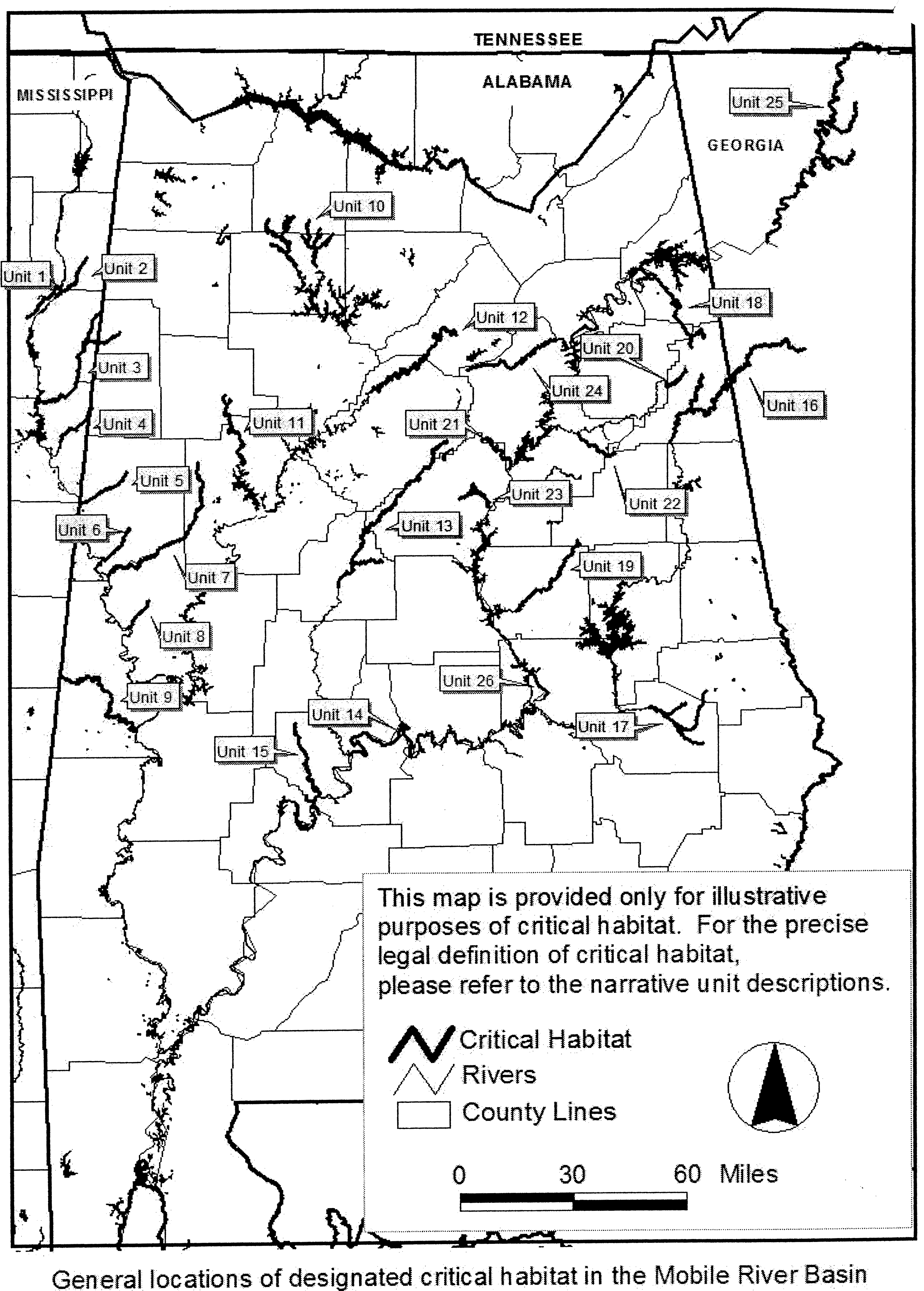
Because portions of the historic range of each of the 11 mussels were shared with 4 or more of the other mussel species, there is considerable overlap Start Printed Page 40100between species' current and historical distributions within these 25 habitat units. This offers opportunities to increase each species' current range and number of extant populations into units currently occupied by other listed species included in this designation. For example, the Alabama moccasinshell historically inhabited 16 of the units, and currently inhabits 7; fine-lined pocketbook was known from 12 of the units, and currently inhabits 10; orange-nacre mucket historically occupied 15 units, and is currently found in 12; and Coosa moccasinshell historically occupied 9 of the units, but is currently found in only 1. Successful reintroduction of the species into units that they historically occupied (and that are currently occupied by 1 or more of the 11 species) would expand the number of populations, thereby reducing threat of extinction. Each of the 25 habitat units (Units 1-25) are currently occupied by 1 or more of the listed mussels. Only two occupied habitat units and one unoccupied habitat unit are designated for the dark pigtoe because its range was naturally restricted to the Black Warrior River drainage, and we are unable to identify any other unoccupied habitat units in the drainage that provide constituent elements.
As noted above, conservation of these species requires expanding their ranges into unoccupied portions of historic habitat. Therefore, in addition to these 25 habitat units, we also designate the Coosa River below Jordan Dam (Unit 26) as critical habitat for 9 of the 11 mussel species. Shells of the fine-lined pocketbook were last collected from this reach in 1989 (Pierson, 1991a), and it is also within the historic range of 8 other species. This is the only unit currently not occupied by at least 1 of the 11 species (Johnson, 2002). This area has recently been identified as presenting high potential for the successful reintroduction of imperiled mussels in the Coosa River drainage (Johnson, 2002). In 1990, the Alabama Power Company increased minimum flows below Jordan Dam into the Coosa River channel from about 70 cubic feet per second (cfs) to 2000 cfs (Federal Energy Regulatory Commission (FERC), 1990), greatly improving aquatic habitat quality. The lower Coosa River not only offers high-quality riverine habitat, but due to local geology, it is relatively protected from non-point runoff, a major threat to all existing populations of these species. There are historic records of fine-lined pocketbook and southern clubshell from this 13 km (8 mi) reach of river (Johnson, 2002; Pierson, 1991a), and it is within the historic range of Alabama moccasinshell, Coosa moccasinshell, ovate clubshell, southern pigtoe, triangular kidneyshell, southern acornshell, and upland combshell. As noted above, threats to these species can be reduced by expanding their current ranges through reintroduction into suitable habitats. Since the Coosa River below Jordan Dam is viewed by experts as a high-quality example of remaining mussel habitat in the Basin, and is recognized as presenting the best opportunity for reestablishing mussel populations (Johnson 2002), we believe it is also essential for the conservation of these 9 mussel species, and designate it as unoccupied habitat.
As a result, we have defined 26 habitat units encompassing approximately 1,760 km (1,093 mi) of stream and river channels in Alabama, Mississippi, Georgia, and Tennessee, for these 11 mussel species (Figure 1). Although this represents only a small proportion of each species' historic range, these habitat units include a significant proportion of the Basin's remaining, highest quality, free-flowing rivers and streams, and reflect the variety of small stream to large river habitats historically occupied by each species. Because mussels are naturally restricted by certain physical conditions within a stream or river reach (i.e., flow, substrate), they may be unevenly distributed within these habitat units. Uncertainty on upstream and downstream distributional limits of some populations may have resulted in small areas of occupied habitat excluded from, or areas of unoccupied habitat included in, the designation.
We recognize that both historic and recent collection records upon which we relied are incomplete, and that there are river segments or small tributaries not included in this final designation that may harbor small, limited populations of one or more of the 11 species considered in this designation, or that others may become suitable in the future. The exclusion of such areas does not diminish their potential individual or cumulative importance to the conservation of these species. However, we believe that with proper management each of the 26 habitat units are capable of supporting 1 or more of these 11 species, and will serve as source populations for artificial reintroduction into designated stream units, as well as assisted or natural migration into adjacent undesignated streams within the Basin.
At this time, the habitat areas contained within the units described below constitute our best evaluation of areas needed for the conservation of these species at this time. Critical habitat may be revised for any or all of these species should new information become available.
Need for Special Management Consideration or Protection
When designating critical habitat, we assess whether the areas determined to be essential for conservation may require special management considerations or protections. All 26 critical habitat units identified in this final designation may require special management considerations or protection to maintain geomorphic stability, water quantity or quality, substrates, presence of fish hosts, or to prevent or control exotic competing or predaceous species. All of these units are threatened by actions that alter he stream slope (e.g., channelization, instream mining, impoundment) or create significant changes in the annual water or sediment budget (e.g., urbanization, deforestation, water withdrawal); point and/or nonpoint source pollution that results in contamination, nutrification, or sedimentation; and the introduction or augmentation of nonnative species that may compete with or prey on the mussel species inhabiting the units (e.g., Asian clams, zebra or quagga mussels, black carp). Habitat fragmentation, population isolation, and small population size compounds these threats to the species. Various activities in or adjacent to each of the critical habitat units described in this final rule may affect one or more of the primary constituent elements that are found in the unit. These activities include, but are not limited to, those listed below in the “Effects of Critical Habitat” section as “Federal Actions That May Affect Critical Habitat and Require Consultation.” None of the critical habitat units is presently under special management or protection provided by a legally operative plan or agreement for the conservation of these mussels. These threats may render the habitat less suitable for these 11 mussels, therefore, we have determined that the critical habitat units may require special management or protection. At this time, special management considerations under 3(5)(a) of the Act warrant designating these units as critical habitat.
Critical Habitat Designation
The areas that we are designating as critical habitat for the 11 mussel species provide one or more of the primary constituent elements described above. In accordance with the Mobile River Aquatic Ecosystem Recovery Plan Start Printed Page 40101(2000), protection of the habitat in these units and their surviving populations is essential to the conservation of these 11 mussel species. All of the designated areas require special management considerations to ensure their contribution to the conservation of these mussels. For each stream reach identified as a critical habitat unit, the up- and downstream boundaries are described in general detail below; more precise estimates are provided in the Regulation Promulgation of this rule.
Critical Habitat Unit Descriptions
The critical habitat units described below include the stream and river channels within the ordinary high water line. As defined in 33 CFR 329.11, the ordinary high water line on nontidal rivers is the line on the shore established by the fluctuations of water and indicated by physical characteristics such as a clear, natural line impressed on the bank; shelving; changes in the character of soil; destruction of terrestrial vegetation; the presence of litter and debris; or other appropriate means that consider the characteristics of the surrounding areas. We are designating the following areas as critical habitat for the 11 mussel species (Refer to Table 1 for the location and extent of critical habitat designated for each species and more specifically to § 17.95, Critical habitat-fish and wildlife, at the end of this rule).
Start Printed Page 40104Table 1.—Approximate River Distances, by Drainage, for Occupied and Unoccupied Critical Habitat for the 11 Mussel Species *
Species, status, critical habitat unit, and state Current occupied Currently unoccupied Kilometers Miles Kilometers Miles Alabama moccasinshell—THREATENED 1. East Fork Tombigbee River, MS 26 16 2. Bull Mountain Creek, MS 34 21 3. Buttahatchee River, MS, AL 110 68 4. Luxapalila Creek, MS, AL 29 18 5. Coalfire Creek, AL 32 20 6. Lubbub Creek, AL 31 19 7. Sipsey River, AL 90 56 8. Trussels Creek, AL 21 13 9. Sucarnoochee River, AL 90 56 10. Sipsey Fork, AL 147 91 11. North River, AL 47 29 12. Locust Fork, AL 102 63 13. Cahaba River, AL 124 77 15. Bogue Chitto Creek, AL 52 32 25. Oostanuala complex, GA, TN 16 10 191 119 26. Lower Coosa River, AL 13 8 Total 457 283 698 433 Fine-lined pocketbook—THREATENED 13. Cahaba River, AL 124 77 16. Tallapoosa River, AL, GA 161 100 17. Uphapee complex, AL 74 46 18. Coosa River, AL 78 48 19. Hatchet Creek, AL 66 41 20. Shoal Creek, AL 26 16 21. Kelly Creek, AL 34 21 22. Cheaha Creek, AL 27 17 23. Yellowleaf Creek, AL 39 24 24. Big Canoe Creek, AL 29 18 25. Oostanaula complex, GA, TN 115 71 92 57 26. Lower Coosa River, AL 13 8 TOTAL 744 461 134 83 Orange-nacre mucket—THREATENED 1. East Fork Tombigbee River, MS 26 16 2. Bull Mountain Creek, MS 34 21 3. Buttahatchee River, MS, AL 87 54 23 14 4. Luxapalila Creek, MS, AL 29 18 5. Coalfire Creek, AL 32 20 6. Lubbub Creek, AL 31 19 7. Sipsey River, AL 90 56 8. Trussels Creek, AL 21 13 9. Sucarnoochee River, AL 90 56 10. Sipsey Fork, AL 147 91 11. North River, AL 47 29 12. Locust Fork, AL 102 63 13. Cahaba River, AL 124 77 14. Alabama River, AL 73 45 Start Printed Page 40102 15. Bogue Chitto Creek, AL 52 32 Total 788 480 220 136 Coosa moccasinshell—ENDANGERED 18. Coosa River, AL 78 48 19. Hatchet Creek, AL 66 41 20. Shoal Creek, AL 26 16 21. Kelly Creek, AL 34 21 22. Cheaha Creek, AL 27 17 23. Yellowleaf Creek, AL 39 24 24. Big Canoe Creek, AL 29 18 25. Oostanaula Complex, GA, TN 115 71 92 57 26. Lower Coosa River, AL 13 8 Total 115 71 404 250 Dark pigtoe—ENDANGERED 10. Sipsey Fork, AL 147 91 11. North River, AL 47 29 12. Locust Fork, AL 102 63 Total 194 120 102 63 Ovate clubshell—ENDANGERED 1. East Fork Tombigbee River, MS 26 16 2. Bull Mountain Creek, MS 34 21 3. Buttahatchee River, MS, AL 87 54 23 14 4. Luxapalila Creek, MS, AL 29 18 5. Coalfire Creek, AL 32 20 6. Lubbub Creek, AL 31 19 7. Sipsey River, AL 90 56 8. Trussels Creek, AL 21 13 9. Sucarnoochee River, AL 90 56 10. Sipsey Fork, AL 147 91 11. North River, AL 47 29 12. Locust Fork, AL 102 63 13. Cahaba River, AL 124 77 17. Uphapee complex, AL 74 46 18. Coosa River, AL 78 48 19. Hatchet Creek, AL 66 41 21. Kelly Creek, AL 34 21 24. Big Canoe Creek, AL 29 18 25. Oostanaula complex, GA, TN 206 128 26. Lower Coosa River, AL 13 8 Total 402 250 981 607 Southern clubshell—ENDANGERED 1. East Fork Tombigbee River, MS 26 16 2. Bull Mountain Creek, MS 34 21 3. Buttahatchee River, MS, AL 87 54 23 14 4. Luxapalila Creek, MS, AL 29 18 5. Coalfire Creek, AL 32 20 6. Lubbub Creek, AL 31 19 7. Sipsey River, AL 90 56 8. Trussels Creek, AL 21 13 9. Sucarnoochee River, AL 90 56 13. Cahaba River, AL 124 77 14. Alabama River, AL 73 45 15. Bogue Chitto Creek, AL 52 32 17. Uphapee Complex, AL 74 46 18. Coosa River, AL 71 44 7 4 19. Hatchet Creek, AL 66 41 21. Kelly Creek, AL 26 16 8 5 24. Big Canoe Creek, AL 29 18 Start Printed Page 40103 25. Oostanaula Complex, GA, TN 15 9 193 120 26. Lower Coosa River, AL 13 8 Total 637 394 577 358 Southern pigtoe—ENDANGERED 18. Coosa River, AL 78 48 19. Hatchet Creek, AL 66 41 20. Shoal Creek, AL 26 16 21. Kelly Creek, AL 34 21 22. Cheaha Creek, AL 27 17 23. Yellowleaf Creek, AL 39 24 24. Big Canoe Creek, AL 29 18 25. Oostanaula Complex, GA, TN 115 71 92 57 26. Lower Coosa River, AL 13 8 Total 197 122 322 199 Triangular kidneyshell—ENDANGERED 10. Sipsey Fork, AL 147 91 11. North River, AL 47 29 12. Locust Fork, AL 102 63 13. Cahaba River, AL 105 65 19 12 18. Coosa River, AL 78 48 19. Hatchet Creek, AL 66 41 20. Shoal Creek, AL 26 16 21. Kelly Creek, AL 26 16 8 5 22. Cheaha Creek, AL 27 17 23. Yellowleaf Creek, AL 39 24 24. Big Canoe Creek, AL 29 18 25. Oostanaula Complex, GA, TN 206 128 26. Lower Coosa River, AL 13 8 Total 641 397 297 184 Southern acornshell—ENDANGERED 13. Cahaba River, AL 124 77 18. Coosa River, AL 78 48 19. Hatchet Creek, AL 66 41 21. Kelly Creek, AL 34 21 24. Big Canoe Creek, AL 29 18 25. Oostanaula Complex, GA, TN 205 128 26. Lower Coosa River, AL 13 8 Total 549 341 Upland combshell—ENDANGERED 12. Locust Fork, AL 102 63 13. Cahaba River, AL 124 77 18. Coosa River, AL 78 48 19. Hatchet Creek, AL 66 41 21. Kelly Creek, AL 34 21 24. Big Canoe Creek, AL 29 18 25. Oostanaula Complex, GA, TN 205 128 26. Lower Coosa River, AL 13 8 Total 651 404 * Table 1 refers to the location and extent of critical habitat designated for each species. For more detail, refer to § 17.95. Table 1 will reflect totals on a species level only, because units are listed under each species as appropriate. Upper Tombigbee River Drainage, Alabama, Mississippi
The Tombigbee River and several of its tributaries above the confluence of the Black Warrior River historically supported robust populations of the orange-nacre mucket, Alabama moccasinshell, southern clubshell, and ovate clubshell. Construction of navigation dams has eliminated these species from the mainstem river, and the dams and impounded waters isolate all surviving tributary populations from each other. The river and stream reaches identified in the nine units below contain primary constituent elements (e.g., flow, water quality, substrate, channel stability) to a degree that allows the survival of one or more of the four species listed above and may be suitable for reintroduction of one or more of the four mussels. Fish hosts for these species are known or believed to be present (Mettee et. al, 1996; Ross, 2001). The introduced Asian clam is locally present in low to moderate numbers.
Unit 1. East Fork Tombigbee River, Monroe, Itawamba Counties, Mississippi
Unit 1 encompasses 26 km (16 mi) of the East Fork Tombigbee River channel in Mississippi extending from Mississippi Highway 278, Monroe County, upstream to the confluence of Mill Creek, Itawamba County, Mississippi. This reach of the East Fork Tombigbee River continues to support the southern clubshell and orange-nacre mucket (Hartfield and Jones, 1989; Miller and Hartfield, 1988; Mississippi Museum of Natural Science (MMNS) mussel collections, 1984-2001). This unit is within the historic range of the Alabama moccasinshell and ovate clubshell.
Unit 2. Bull Mountain Creek, Itawamba County, Mississippi
Unit 2 encompasses 34 km (21 mi) of the Bull Mountain Creek stream channel in Mississippi extending from Mississippi Highway 25, upstream to U.S. Highway 78, Itawamba County, Mississippi. Bull Mountain Creek supports the southern clubshell and Alabama moccasinshell (Jones and Majure, 1999). This unit is within the historic range of the orange-nacre mucket (records are from the early 1980's (MMNS mussel collections)) and the ovate clubshell.
Unit 3. Buttahatchee River and tributary, Lowndes/Monroe County, Mississippi; Lamar County, Alabama
Unit 3 encompasses 110 km (68 mi) of river and stream channel in Mississippi and Alabama, including 87 km (54 mi) of the Buttahatchee River, extending from its confluence with the impounded waters of Columbus Lake (Tombigbee River), Lowndes/Monroe County, Mississippi, upstream to the confluence of Beaver Creek, Lamar County, Alabama; and 23 km (14 mi) of Sipsey Creek, extending from its confluence with the Buttahatchee River, upstream to the Mississippi/Alabama State Line, Monroe County, Mississippi. The Buttahatchee River continues to support and provide habitat for the southern clubshell, orange-nacre mucket, ovate clubshell, and Alabama moccasinshell (Haag and Warren, 2001; Hartfield and Jones, 1989; Jones, 1991; McGregor, 2000). The current distribution of the Alabama moccasinshell also extends into its tributary Sipsey Creek (McGregor, 2000).
Unit 4. Luxapalila Creek and tributary, Lowndes County, Mississippi; Lamar County, Alabama
Unit 4 encompasses 29 km (18 mi) of stream channel, including 15 km (9 mi) of Luxapalila Creek, extending from Waterworks Road, Columbus, Mississippi, upstream to approximately 1.0 km (0.6 mi) above Steens Road, Lowndes County, Mississippi; and 15 km (9 mi) of Yellow Creek extending from its confluence with Luxapalila Creek, upstream to the confluence of Cut Bank Creek, Lamar County, Alabama. Luxapalila and Yellow Creeks support and provide habitat for the southern clubshell, orange-nacre mucket, ovate clubshell, and Alabama moccasinshell (Hartfield and Bowker, 1992; McGregor, 2000; Miller, 2000; Yokley 2001).
Unit 5. Coalfire Creek, Pickens County, Alabama
Unit 5 encompasses 32 km (20 mi) of the Coalfire Creek stream channel extending from its confluence with the impounded waters of Aliceville Lake (Tombigbee River), upstream to U.S. Highway 82, Pickens County, Alabama. Coalfire Creek supports the orange-nacre mucket and ovate clubshell (P. Hartfield, Service field records 1991; McGregor, 2000). The creek is in the historic range of the southern clubshell and Alabama moccasinshell.
Unit 6. Lubbub Creek, Pickens County, Alabama
Unit 6 encompasses 31 km (19 mi) of the Lubbub Creek stream channel extending from its confluence with the impounded waters of Gainesville Lake (Tombigbee River), upstream to the confluence of Little Lubbub Creek, Pickens County, Alabama. This stream supports the southern clubshell, orange-nacre mucket, and Alabama moccasinshell (P. Hartfield, Service field records, 1991; McGregor, 2000; Pierson, 1991a). It is in the historic range of the ovate clubshell.
Unit 7. Sipsey River, Greene/Pickens, Tuscaloosa Counties, Alabama
Unit 7 encompasses 90 km (56 mi) of the Sipsey River channel from the confluence with the impounded waters of Gainesville Lake (Tombigbee River), Greene/Pickens County, upstream to Alabama Highway 171 crossing, Tuscaloosa County, Alabama. This small river supports and provides some of the best remaining habitat for the southern clubshell, orange-nacre mucket, ovate clubshell, and Alabama moccasinshell (Haag and Warren, 1997; McCullagh et al., 2002; McGregor, 2000; MMNS Mussel Collection; Pierson, 1991 a, b).
Unit 8. Trussels Creek, Greene County, Alabama
Unit 8 encompasses 21 km (13 mi) of creek channel extending from its confluence with the impounded waters of Demopolis Lake (Tombigbee River), upstream to Alabama Highway 14, Greene County, Alabama. The orange-nacre mucket continues to survive in Trussels Creek, and it is in the historic range of the ovate clubshell, Alabama moccasinshell, and southern clubshell (P. Hartfield field records, 1993; McGregor, 2000).
Unit 9. Sucarnoochee River, Sumter County, Alabama
Unit 9 encompasses 90 km (56 mi) of the Sucarnoochee River channel in Alabama, extending from its confluence with the Tombigbee River, upstream to the Mississippi/Alabama State Line, Sumter County, Alabama. The ovate clubshell continues to survive in the Sucarnoochee River (McGregor et al., 1996). The river is within the historic range of the southern clubshell, orange-nacre mucket, and Alabama moccasinshell.
Black Warrior River Drainage, Alabama
The Black Warrior River and its tributaries historically supported populations of the orange-nacre mucket, Alabama moccasinshell, Coosa moccasinshell, southern clubshell, ovate clubshell, dark pigtoe, triangular kidneyshell, and upland combshell. There are also records of the fine-lined pocketbook from the drainage. Dam construction for navigation and hydropower and episodic water pollution resulted in the extirpation of the Coosa moccasinshell, southern Start Printed Page 40105clubshell, ovate clubshell, and upland combshell from this drainage. The tributary drainages identified in the three units below contain primary constituent elements (e.g., flow, water quality, substrate, channel stability) to a degree that allows the survival of two or more endangered or threatened mussels and may be suitable for reintroduction of one or more of the mussels. Fish hosts for these species are also known to be present (Mettee et. al., 1996). The introduced Asian clam is locally present in these drainages in low to high densities. Dams and impounded waters currently isolate these drainages from each other.
Unit 10. Sipsey Fork drainage, Winston, Lawrence Counties, Alabama
Unit 10 encompasses 147 km (91 mi) of stream channel in Alabama, including: Sipsey Fork, 31 km (19 mi), from section 11/12 line, T10S R8W, Winston County, upstream to the confluence of Hubbard Creek, Lawrence County, Alabama; Thompson Creek, 8 km (5 mi), from confluence with Hubbard Creek, upstream to section 2 line, T8S R9W, Lawrence County, Alabama; Brushy Creek, 35 km (22 mi), from the confluence of Glover Creek, Winston County, Alabama, upstream to section 9, T8S R7W, Lawrence County, Alabama; Capsey Creek, 15 km (9 mi), from confluence with Brushy Creek, Winston County, upstream to the confluence of Turkey Creek, Lawrence County, Alabama; Rush Creek, 10 km (6 mi), from confluence with Brushy Creek, upstream to Winston/Lawrence County Line, Winston County, Alabama; Brown Creek, 5 km (3 mi), from confluence with Rush Creek, Winston County, upstream to section 24 line, T8S R7W Lawrence County, Alabama; Beech Creek, 3 km (2 mi), from confluence with Brushy Creek, to confluence of East and West Forks, Winston County, Alabama; Caney Creek and North Fork Caney Creek, 13 km (8 mi), from confluence with Sipsey Fork, upstream to section 14 line, Winston County, Alabama; Borden Creek, 18 km (11 mi), from confluence with Sipsey Fork, Winston County, Alabama, upstream to the confluence of Montgomery Creek, Lawrence County, Alabama; Flannagin Creek, 10 km (6 mi), from confluence with Borden Creek, upstream to confluence of Dry Creek, Lawrence County, Alabama. The upper Sipsey Fork drainage currently supports the most robust and extensive populations of the dark pigtoe, orange-nacre mucket, Alabama moccasinshell, and triangular kidneyshell (Haag and Warren, 1997; Haag et al., 1995; Hartfield, 1991; Hartfield and Butler, 1997; Hartfield and Hartfield, 1996; McGregor, 1992; Warren and Haag, 1994). Ovate clubshell have been reported from this drainage (Dodd et al., 1986).
Unit 11. North River and tributary, Tuscaloosa, Fayette Counties, Alabama
Unit 11 encompasses 47 km (29 mi) of river and stream channel in Alabama, including: North River, 42 km (26 mi) extending from Tuscaloosa County Road 38, Tuscaloosa County, upstream to confluence of Ellis Creek, Fayette County, Alabama; Clear Creek, 5 km (3 mi), from its confluence with North River, to Bays Lake Dam, Fayette County, Alabama. Small numbers of the dark pigtoe and orange-nacre mucket continue to survive in the North River and Clear Creek (McGregor and Pierson, 1999; Pierson, 1992a; Vittor and Associates, 1993). This area is in the historic range of the Alabama moccasinshell, triangular kidneyshell, and ovate clubshell.
Unit 12. Locust Fork and tributary, Jefferson, Blount Counties, Alabama
Unit 12 encompasses 102 km (63 mi) of river and stream channel in Alabama, including: Locust Fork, 94 km (58 mi) extending from U.S. Highway 78, Jefferson County, upstream to the confluence of Little Warrior River, Blount County, Alabama; Little Warrior River, 8 km (5 mi), from its confluence with the Locust Fork, upstream to the confluence of Calvert Prong and Blackburn Fork, Blount County, Alabama. Scattered collections of the orange-nacre mucket and triangular kidneyshell suggest an enduring population of these species in the Locust Fork (P. Johnson pers. comm., 2002; Hartfield, 1991; Shepard et al., 1988). This stream is also in the historic range of the dark pigtoe, Alabama moccasinshell, ovate clubshell, and upland combshell.
Cahaba River Drainage, Alabama
The Cahaba River and tributaries historically supported the orange-nacre mucket, fine-lined pocketbook, Alabama moccasinshell, southern clubshell, ovate clubshell, triangular kidneyshell, upland combshell, and southern acornshell. Episodic and persistent pollution events have caused the decline of the mussel community throughout the drainage, as well as the extirpation of five of the listed mussels. The habitat unit described below contains primary constituent elements (e.g., flow, water quality, substrate, channel stability) to a degree that allows the survival of the orange-nacre mucket, fine-lined pocketbook, and triangular kidneyshell and may be suitable for reintroduction of five of the 11 mussels. Fish hosts for these species are also known to be present (Mettee et. al., 1996). The introduced Asian clam is locally present in these drainages in low to high densities.
Unit 13. Cahaba River and tributary, Jefferson, Shelby, Bibb Counties, Alabama
Unit 13 encompasses 124 km (77 mi) of river channel in Alabama, including: Cahaba River, 105 km (65 mi) extending from U.S. Highway 82, Centerville, Bibb County, upstream to Jefferson County Road 143, Jefferson County, Alabama; Little Cahaba River, 19 km (12 mi), from its confluence with the Cahaba River, upstream to the confluence of Mahan and Shoal Creeks, Bibb County, Alabama. Scattered individuals of triangular kidneyshell, orange-nacre mucket, and fine-lined pocketbook continue to be collected from the Cahaba drainage (R. Haddock, Cahaba River Society, pers. comm., 2002; McGregor et al., 2000; Shepard et al., 1994). The river is historic habitat for the Alabama moccasinshell, southern clubshell, ovate clubshell, upland combshell, and southern acornshell.
Alabama River Drainage, Alabama
The Alabama River mollusk community has been reduced due to the effects of historic pollution events and impoundment for navigation. Historical records from this river include the Alabama moccasinshell, orange-nacre mucket, fine-lined pocketbook, triangular kidneyshell, and southern clubshell. The habitat units defined below contain primary constituent elements (e.g., flow, water quality, substrate, channel stability) to a degree that allows the survival of two of these mussels. Fish hosts for these species are also known to be present (Mettee et al., 1996). The introduced Asian clam is locally present in these drainages in low to moderate densities.
Unit 14. Alabama River, Autauga, Lowndes, Dallas Counties, Alabama
Unit 14 encompasses 73 km (45 mi) of the Alabama River channel, extending from the confluence of the Cahaba River, Dallas County, upstream to the confluence of Big Swamp Creek, Lowndes County, Alabama. The southern clubshell is known to occur within this reach (Hartfield and Garner, 1998). This area may become suitable for reintroduction of the orange-nacre mucket. Start Printed Page 40106
Unit 15. Bogue Chitto Creek, Dallas County, Alabama
Unit 15 encompasses 52 km (32 mi) of the Bogue Chitto Creek channel in Alabama, extending from its confluence with the Alabama River, Dallas County, upstream to U.S. Highway 80, Dallas County, Alabama. This stream continues to support the southern clubshell and orange-nacre mucket (McGregor et al., 1996; P. Hartfield field notes, 1984; Pierson, 1991a). The habitat offers potential for the Alabama moccasinshell.
Tallapoosa River Drainage, Alabama, Georgia
Historical and recent records indicate that the Tallapoosa River drainage supported a diverse mussel community, although numbers of all mussel species have apparently always been low in this system. The two habitat units identified below contain primary constituent elements (e.g., flow, water quality, substrate, channel stability) to a degree that allows the survival of three of the listed mussels and may be suitable for reintroduction of one or more of the 11 mussels. Fish hosts for these species are also known to be present (Mettee et al., 1996). The introduced Asian clam is locally present in these drainages in low to moderate densities.
Unit 16. Tallapoosa River and tributary, Cleburne County, Alabama and Haralson and Paulding Counties, Georgia
Unit 16 encompasses 161 km (100 mi) of river and stream channel in Alabama and Georgia, including: Tallapoosa River, 137 km (85 mi) extending from U.S. Highway 431, Cleburne County, Alabama, upstream to the confluence of McClendon and Mud Creeks, Paulding County, Georgia; and Cane Creek, 24 km (15 mi), from confluence with Tallapoosa River, upstream to Section 33/4 Line (T15S, R11E), Cleburne County, Alabama. This extensive area of main channel and tributary habitat supports scattered, small numbers of the fine-lined pocketbook (Devris, 1997; Irwin et al., 1998; Irwin pers. comm., 2000). There have been site collections of fine-lined pocketbook in the extreme lowest reaches of several small tributaries to the Tallapoosa Unit, including Little Cane Creek, Big Creek, McClendon Creek, and Muscadine Creek, and there are likely to be others. We believe these small populations are dependent upon the main stem Tallapoosa River for recruitment.
Unit 17. Uphapee/Choctafaula/Chewacla Creeks, Macon, Lee Counties, Alabama
Unit 17 encompasses 74 km (46 mi) of stream channel in Alabama, including: Uphapee Creek, 18 km (11 mi) of river channel extending from Alabama Highway 199, upstream to confluence of Opintlocco and Chewacla Creeks, Macon County, Alabama; Choctafaula Creek, 11 km (7 mi), from confluence with Uphapee Creek, upstream to Macon County Road 54, Macon County, Alabama; Chewacla Creek, 29 km (18 mi), from confluence with Opintlocco Creek, Macon County, Alabama, upstream to Lee County Road 159, Lee County, Alabama; Opintlocco Creek, 16 km (10 mi), from confluence with Chewacla Creek, upstream to Macon County Road 79, Macon County, Alabama. This stream network supports small and localized populations of the fine-lined pocketbook, ovate clubshell, and southern clubshell (M. Gangloff, Auburn University, in litt., 2001; Gangloff, 2002; McGregor, 1993; Pierson, 1991a).
Coosa River Drainage, Alabama, Georgia, Tennessee
Extensive impoundment for hydropower during the 20th century along with episodic pollution events severely reduced one of the most diverse endemic freshwater mollusk communities in the world. The river and stream reaches in eight of the nine units identified below contain primary constituent elements (e.g., flow, water quality, substrate, channel stability) to a degree that allows the survival of two or more endangered or threatened mussels and may be suitable for reintroduction of one or more of the 11 mussels. Fish hosts for these species are also known to be present (Mettee et al., 1996). Constituent elements in Unit 26 have improved to a degree that survival of extirpated endangered and threatened species may now be possible (Johnson, 2002). The introduced Asian clam is locally present in these units in low to high densities.
Unit 18. Coosa River (Old River Channel) and tributary, Cherokee, Calhoun, Cleburne Counties, Alabama
Unit 18 encompasses 78 km (48 mi) of river channel in Alabama, including: Coosa River, 18 km (11 mi) extending from the powerline crossing southeast of Maple Grove, Alabama, upstream to Weiss Dam, Cherokee County, Alabama; Terrapin Creek, 53 km (33 mi) extending from its confluence with the Coosa River, Cherokee County, upstream to Cleburne County Road 49, Cleburne County, Alabama; South Fork Terrapin Creek, 7 km (4 mi) from its confluence with Terrapin Creek, upstream to Cleburne County Road 55, Cleburne County, Alabama. The short reach of the Coosa River continues to support a fairly robust population of the southern clubshell, and a few individuals of the fine-lined pocketbook (Herod et al., 2001). The fine-lined pocketbook and southern clubshell have also been recently collected from Terrapin Creek (Feminella and Gangloff, 2000). This area is within the range of the Coosa moccasinshell, southern pigtoe, ovate clubshell, triangular kidneyshell, upland combshell, and southern acornshell.
Unit 19. Hatchet Creek, Coosa, Clay Counties, Alabama
Unit 19 encompasses 66 km (41 mi) of the Hatchet Creek channel in Alabama, extending from the confluence of Swamp Creek at Coosa County Road 29, Coosa County, Alabama, upstream to Clay County Road 4, Clay County, Alabama. The fine-lined pocketbook occurs within this reach (Feminella and Gangloff, 2000; Pierson, 1992b). Hatchet Creek is within the historic range of the Coosa moccasinshell, southern pigtoe, ovate clubshell, southern clubshell, triangular kidneyshell, upland combshell, and southern acornshell.
Unit 20. Shoal Creek, Calhoun, Cleburne Counties, Alabama
Unit 20 encompasses 26 km (16 mi) of stream channel in Alabama, extending from the headwater of Whitesides Mill Lake, Calhoun County, Alabama, upstream to the tailwater of Coleman Lake Dam, Cleburne County, Alabama. The fine-lined pocketbook, southern pigtoe, and triangular kidneyshell survive in Shoal Creek (Haag et al., 1999; Feminella and Gangloff, 2000; Gangloff in litt., 2001; Pierson, 1992b). Shoal Creek is within historic range of the Coosa moccasinshell.
Unit 21. Kelly Creek and tributary, Shelby, St. Clair Counties, Alabama
Unit 21 encompasses 34 km (21 mi) of stream channel in Alabama, including: Kelly Creek, 26 km (16 mi) extending from the confluence with the Coosa River, upstream to the confluence of Shoal Creek, St. Clair County, Alabama; Shoal Creek, 8 km (5 mi), from confluence with Kelly Creek, St. Clair County, Alabama, upstream to St. Clair/Shelby County Line, St. Clair County, Alabama. Kelly/Shoal Creeks continue to support scattered individuals of the fine-lined pocketbook, and the southern clubshell and triangular kidneyshell Start Printed Page 40107survive in Kelly Creek (Pierson pers. comm., 1995; Feminella and Gangloff, 2000; Gangloff in litt., 2001). This stream complex is historic habitat for the southern pigtoe, Coosa moccasinshell, ovate clubshell, upland combshell, and southern acornshell.
Unit 22. Cheaha Creek, Talladega, Clay Counties, Alabama
Unit 22 encompasses 27 km (17 mi) of the Cheaha Creek channel, extending from its confluence with Choccolocco Creek, Talladega County, Alabama, upstream to the tailwater of Chinnabee Lake, Clay County, Alabama. The fine-lined pocketbook and southern pigtoe survive within this reach (Feminella and Gangloff, 2000; Gangloff in litt., 2001; Pierson, 1992b, 1993). Cheaha Creek is in the historic range of the Coosa moccasinshell and triangular kidneyshell.
Unit 23. Yellowleaf Creek and tributary, Shelby County, Alabama
Unit 23 encompasses 39 km (24 mi) of stream channel, including: Yellowleaf Creek, 32 km (20 mi), extending from Alabama Highway 25, upstream to Shelby County Road 49; Muddy Prong, 7 km (4 mi), extending from confluence with Yellowleaf Creek, upstream to U.S. Highway 280, Shelby County, Alabama. Yellowleaf and Muddy Prong Creeks are currently inhabited by the fine-lined pocketbook (Feminella and Gangloff, 2000; Gangloff in litt., 2001; Pierson in litt., 2000). Yellowleaf Creek is in the historic range of the Coosa moccasinshell, southern pigtoe, and triangular kidneyshell.
Unit 24. Big Canoe Creek, St. Clair County, Alabama
Unit 24 encompasses 29 km (18 mi) of the Big Canoe Creek channel, extending from its confluence with Little Canoe Creek at the St. Clair/Etowah County line, St. Clair County, upstream to the confluence of Fall Branch, St. Clair County, Alabama. The southern clubshell, southern pigtoe, and triangular kidneyshell are surviving in low numbers in Big Canoe Creek (Feminella and Gangloff, 2000; Gangloff in litt., 2001). This stream is also historic habitat for the fine-lined pocketbook, ovate clubshell, Coosa moccasinshell, upland combshell, and southern acornshell.
Unit 25. Oostanaula River/Coosawattee River/Conasauga River/Holly Creek, Floyd, Gordon, Whitfield, Murray Counties, Georgia; Bradley, Polk Counties, Tennessee
Unit 25 encompasses 206 km (128 mi) of river and stream channel in Georgia and Tennessee, including: Oostanaula River, 77 km (48 mi) extending from its confluence with the Etowah River, Floyd County, upstream to the confluence of the Conasauga and Coosawattee River, Gordon County, Georgia; Coosawattee River, 15 km (9 mi), from confluence with the Conasauga River, upstream to Georgia State Highway 136, Gordon County, Georgia; Conasauga River, 98 km (61 mi), from confluence with the Coosawattee River, Gordon County, Georgia, upstream through Bradley and Polk Counties, Tennessee, to the Murray County Road 2, Murray County, Georgia; Holly Creek, 16 km (10 mi), from confluence with Conasauga River, upstream to its confluence with Rock Creek, Murray County, Georgia. This extensive riverine reach continues to support small and localized populations of fine-lined pocketbook, southern pigtoe, triangular kidneyshell, Alabama moccasinshell, and Coosa moccasinshell. The triangular kidneyshell survives throughout this unit, while the fine-lined pocketbook, southern pigtoe, and Coosa moccasinshell appear to be currently restricted to the Conasauga River and Holly Creek and the southern clubshell appears restricted to a small 15 km (9 mi) reach of the Conasauga River (Evans, 2001; Johnson and Evans, 2000; Pierson in litt., 1993; Williams and Hughes, 1998). The Alabama moccasinshell is currently known to survive only in the Holly Creek portion of this Unit (Evans, 2001; Johnson and Evans, 2000). The Oostanaula/Coosawattee/Conasauga Unit also contains historic habitat for the southern clubshell, ovate clubshell, upland combshell, and southern acornshell.
Unit 26. Lower Coosa River, Elmore County, Alabama
Unit 26 encompasses 13 km (8 mi) of the Lower Coosa River channel, extending from Alabama State Highway 111 bridge, upstream to Jordan Dam, Elmore County, Alabama. This river reach is within the historic range of fine-lined pocketbook, southern clubshell, Alabama moccasinshell, Coosa moccasinshell, ovate clubshell, southern pigtoe, triangular kidneyshell, upland combshell, and southern acornshell. (Johnson, 2002; Pierson, 1991a).
Land Ownership
Table 2 summarizes primary adjacent riparian landowners in each of the proposed critical habitat units by private, State, or Federal ownership.
Table 2.—Adjacent Riparian Land Ownership (km[mi]) in Critical Habitat Units for 11 Threatened and Endangered Mussels in the Mobile River Basin
Critical habitat unit Private State Federal Total 1. East Fork Tombigbee River 19(12) 6(4) 26(16) 2. Bull Mountain Creek 34(21) 34(21) 3. Buttahatchee River 110(68) 110(68) 4. Luxapalila Creek 29(18) 29(18) 5. Coalfire Creek 32(20) 32(20) 6. Lubbub Creek 31(19) 31(19) 7. Sipsey River 74/(46) 16(10) 90(56) 8. Trussels Creek 21(13) 21(13) 9. Sucarnoochee River 90(56) 90(56) 10. Sipsey Fork 15(9) 132(82) 147(91) 11. North River 47(29) 47(29) 12. Locust Fork 102(63) 102(63) 13. Cahaba River 92(57) 26(16) 6(4) 124(77) 14. Alabama River 73(45) 73(45) 15. Bogue Chitto 52(32) 52(32) 16. Tallapoosa River 161(100) 161(100) 17. Uphapee complex 56(35) 18(11) 74(46) 18. Coosa River 63(39) 15(9) 78(48) Start Printed Page 40108 19. Hatchet Creek 55(34) 11(7) 66(41) 20. Shoal Creek 26(16) 26(16) 21. Kelly Creek 34(21) 34(21) 22. Cheaha Creek 16(10) 11(7) 27(17) 23. Yellowleaf Creek 39(24) 39(24) 24. Big Canoe Creek 29(18) 29(18) 25. Oostanaula Complex 188(117) 18(11) 206(128) 26. Lower Coosa River 13(8) 13(8) Total 1,475(914) 42(26) 243(151) 1,760(1,093) Public lands adjacent to critical habitat units consist of approximately 288 km (179 mi) of riparian lands, including Canal Section Wildlife Management Area in Unit 1 (6 km (4 mi)); Sipsey River Natural Area in Unit 7 (16 km (10 mi)); William B. Bankhead National Forest in Unit 10 (134 km (83 mi)); Cahaba River National Wildlife Refuge (6 km (4 mi)) and Cahaba River Wildlife Management Area (28 km (17 mi)) in Unit 13; Tuskegee National Forest in Unit 17 (16 km (10 mi)); Talladega National Forest in Unit 18 (15 km (9 mi)), Unit 19 (11 km (7 mi)), Unit 20 (27 km (17mi)), and Unit 22 (11 km (7 mi)); and Chattahoochee National Forest in Unit 25 (18 km (11 mi)).
Effects of Critical Habitat Designation
Section 7 Consultation
Section 7 of the Act requires Federal agencies, including the Service, to ensure that actions they fund, authorize, or carry out are not likely to destroy or adversely modify critical habitat.
Section 7(a) of the Act requires Federal agencies, including the Service, to evaluate their actions with respect to any species that is proposed or listed as endangered or threatened and with respect to its critical habitat, if any is proposed or designated. Regulations implementing this interagency cooperation provision of the Act are codified at 50 CFR part 402. Section 7(a)(4) of the Act requires Federal agencies to confer with us on any action that is likely to jeopardize the continued existence of a proposed species or result in destruction or adverse modification of proposed critical habitat. Conference reports provide conservation recommendations to assist the agency in eliminating conflicts that may be caused by the proposed action. The conservation recommendations in a conference report are advisory. If a species is listed or critical habitat is designated, section 7(a)(2) requires Federal agencies to ensure that activities they authorize, fund, or carry out are not likely to jeopardize the continued existence of such a species or to destroy or adversely modify its critical habitat. If a Federal action may affect a listed species or its critical habitat, the responsible Federal agency (action agency) must enter into consultation with us. Through this consultation, the action agency ensures that the permitted actions do not destroy or adversely modify critical habitat.
When we issue a biological opinion concluding that a project is likely to result in the destruction or adverse modification of critical habitat, we also provide reasonable and prudent alternatives to the project, if any are identifiable. “Reasonable and prudent alternatives” are defined at 50 CFR 402.02 as alternative actions identified during consultation that can be implemented in a manner consistent with the intended purpose of the action, that are consistent with the scope of the Federal agency's legal authority and jurisdiction, that are economically and technologically feasible, and that the Director believes would avoid destruction or adverse modification of critical habitat. Reasonable and prudent alternatives can vary from slight project modifications to extensive redesign or relocation of the project. Costs associated with implementing a reasonable and prudent alternative are similarly variable.
Regulations at 50 CFR 402.16 require Federal agencies to reinitiate consultation on previously reviewed actions in instances where critical habitat is subsequently designated and the Federal agency has retained discretionary involvement or control over the action or such discretionary involvement or control is authorized by law. Consequently, some Federal agencies may request reinitiation of consultation or conference with us on actions for which formal consultation has been completed, if those actions may affect designated critical habitat or adversely modify or destroy proposed critical habitat.
We may issue a formal conference report if requested by a Federal agency. Formal conference reports on proposed critical habitat contain an opinion that is prepared according to 50 CFR 402.14, as if critical habitat were designated. We may adopt the formal conference report as the biological opinion when the critical habitat is designated, if no substantial new information or changes in the action alter the content of the opinion (see 50 CFR 402.10(d)).
Activities on Federal lands that may affect these 11 mussels or their critical habitat will require section 7 consultation. Activities on private or State lands requiring a permit from a Federal agency, such as a permit from the USACE under section 404 of the Clean Water Act, a section 10(a)(1)(B) permit from the Service, or some other Federal action, including funding (e.g., Federal Highway Administration or Federal Emergency Management Agency funding), will also continue to be subject to the section 7 consultation process. Federal actions not affecting listed species or critical habitat and actions on non-Federal and private lands that are not federally funded, authorized, or permitted do not require section 7 consultation.
Section 4(b)(8) of the Act requires us to briefly evaluate and describe in any proposed or final regulation that designates critical habitat those activities involving a Federal action that may destroy or adversely modify such habitat, or that may be affected by such designation. Activities that may destroy or adversely modify critical habitat include those that appreciably reduce the value of critical habitat to the 11 mussels. We note that such activities may also jeopardize the continued existence of the species.
To properly portray the effects of critical habitat designation, we must first compare the section 7 requirements for actions that may affect critical Start Printed Page 40109habitat with the requirements for actions that may affect a listed species. Section 7 prohibits actions funded, authorized, or carried out by Federal agencies from jeopardizing the continued existence of a listed species or destroying or adversely modifying the listed species' critical habitat. Actions likely to “jeopardize the continued existence” of a species are those that would appreciably reduce the likelihood of the species' survival and recovery. Actions likely to “destroy or adversely modify” critical habitat are those that would appreciably reduce the value of critical habitat to the listed species.
Common to both definitions is an appreciable detrimental effect on both survival and recovery of a listed species. Given the similarity of these definitions, actions likely to destroy or adversely modify critical habitat would often result in jeopardy to the species concerned when the area of the proposed action is occupied by the species concerned.
Federal agencies already consult with us on activities in areas currently occupied by the species to ensure that their actions do not jeopardize the continued existence of the species. These actions include, but are not limited to:
(1) Actions that would alter the minimum flow or the existing flow regime to a degree that appreciably reduces the value of the critical habitat for both the long-term survival and recovery of the species. Such activities could include, but are not limited to, impoundment, channelization, water diversion, and hydropower generation.
(2) Actions that would significantly alter water chemistry or temperature to a degree that appreciably reduces the value of the critical habitat for both the long-term survival and recovery of the species. Such activities could include, but are not limited to, release of chemicals, biological pollutants, or heated effluents into the surface water or connected groundwater at a point source or by dispersed release (non-point).
(3) Actions that would significantly increase sediment deposition within the stream channel to a degree that appreciably reduces the value of the critical habitat for both the long-term survival and recovery of the species. Such activities could include, but are not limited to, excessive sedimentation from livestock grazing, road construction, timber harvest, off-road vehicle use, and other watershed and floodplain disturbances.
(4) Actions that would significantly increase the filamentous algal community within the stream channel to a degree that appreciably reduces the value of the critical habitat for both the long-term survival and recovery of the species. Such activities could include, but are not limited to, release of nutrients into the surface water or connected groundwater at a point source or by dispersed release (non-point).
(5) Actions that would significantly alter channel morphology or geometry to a degree that appreciably reduces the value of the critical habitat for both the long-term survival and recovery of the species. Such activities could include, but are not limited to, channelization, impoundment, road and bridge construction, mining, destruction of riparian vegetation.
(6) Actions that would introduce, spread, or augment nonnative aquatic species into critical habitat to a degree that appreciably reduces the value of the critical habitat for both the long-term survival and recovery of the species. Such activities could include, but are not limited to, stocking for sport, biological control, or other purposes; aquaculture; and construction and operation of canals.
We consider 25 of the 26 critical habitat units to be occupied by the species because at least one of the 11 mussels occurs in these units. Federal agencies already consult with us on activities in areas currently occupied by the species or if the species may be affected by the action to ensure that their actions do not jeopardize the continued existence of the species.
Previous Section 7 Consultations
Federal actions that we have reviewed since these 11 mussel species received protection under the Act include Federal land management plans, Federal land acquisition and disposal, road and bridge maintenance and construction, water diversion, timber harvest on Federal land, channelization, flood control, channel maintenance, water quality standards, dam construction and operation, and issuance of permits under section 404 of the Clean Water Act. Federal agencies involved with these activities included the U.S. Army Corps of Engineers (USACE), U.S. Forest Service, Natural Resources Conservation Service, Environmental Protection Agency, and Federal Highway Administration. Since the original listing of these 11 mussel species, seven formal consultations have been conducted. None of these resulted in a finding that the proposed action would jeopardize the continued existence of any of the 11 species.
In each of the biological opinions resulting from these consultations, we included discretionary conservation recommendations to the action agency. Conservation recommendations are activities that would avoid or minimize the adverse effects of a proposed action on a listed species or its critical habitat, help implement recovery plans, or develop information useful to the species' conservation.
Previous biological opinions also included nondiscretionary reasonable and prudent measures, with implementing terms and conditions, which are designed to minimize the proposed action's incidental take of these 11 mussels. Section 3(18) of the Act defines the term take as “to harass, harm, pursue, hunt, shoot, wound, kill, trap, capture or collect, or to attempt to engage in any such conduct.” Harm is further defined in our regulations (50 CFR 17.3) to include significant habitat modification or degradation that results in death or injury to listed species by significantly impairing essential behavioral patterns, including breeding, feeding, or sheltering.
Conservation recommendations and reasonable and prudent measures provided in previous biological opinions for these mussels have included maintaining State water quality standards, maintaining adequate stream flow rates, minimizing work in the wetted channel, restricting riparian clearing, monitoring channel morphology and mussel populations, installing signage, protecting buffer zones, avoiding pollution, using cooperative planning efforts, minimizing ground disturbance, using sediment barriers, relocating recreational trails, using best management practices to minimize erosion, and funding research useful for mussel conservation.
The designation of critical habitat will have no impact on private landowner activities that do not require Federal funding or permits. Designation of critical habitat is only applicable to activities approved, funded, or carried out by Federal agencies.
If you have questions regarding whether specific activities would constitute adverse modification of critical habitat, you may contact the following Service offices:
Alabama—Daphne, FWS Ecological Services Office (251/441-5181)
Georgia—Athens, FWS Ecological Services Office (706/613-9493)
Mississippi—Jackson, FWS Ecological Services Office (601/965-4900)
Tennessee—Cookeville, FWS Ecological Services Office (931/528-6481) Start Printed Page 40110
Exclusions Under Section 4(b)(2)
Section 4(b)(2) of the Act requires that we designate critical habitat on the basis of the best scientific and commercial information available, and that we consider the economic and any other relevant impacts of designating a particular area as critical habitat. We may exclude areas from critical habitat if the benefits of exclusion outweigh the benefits of designation, provided the exclusion will not result in the extinction of the species. We have prepared an economic analysis that is consistent with the ruling of the 10th Circuit Court of Appeals in N.M. Cattle Growers Ass'n v. USFWS, and that was available for public review and comment during the comment periods for the proposed rule. The final economic analysis is available from our Web site at http://southeast.fws.gov/hotissue. Since the critical habitat designation includes only aquatic areas that are generally held in public trust, involves no Tribal lands, and includes no areas presently under special management or protection provided by a legally operative plan or agreement for the conservation of these mussels, we believe, other than economics, there are no other relevant impacts to evaluate under section 4(b)(2).
Based on the best available information including the prepared economic analysis, we believe that all of the 26 units are essential for the conservation of these species and have identified no areas where the benefits of exclusion outweigh the benefits of designation. As detailed in our economic analysis, Units 12 and 18 are likely to engender the highest costs on a unit-by-unit basis, accounting for approximately 81 percent of the total costs of the designation. The high cost associated with Unit 12 is attributed to the relocation of a potential reservoir from the Locust Fork River outside of critical habitat to an alternate site in the drainage. The economic analysis for this action includes a range of impacts for this project of $0 to $154 million. However, a previous proposal to impound the Locust Fork River was withdrawn due to public opposition for reasons other than impacts to endangered or threatened species. Exclusion of Unit 12 from the designation will not resolve the existing concerns associated with the potential reservoir site and will not reduce any regulatory requirements under section 7 of the Act because these would already be required due to the existing presence of federally listed species. Moreover, Unit 12 is currently occupied by one endangered and one threatened mussel, in addition to an endangered fish and an endangered snail; all of which are extremely limited in range and threatened with increasing habitat loss, fragmentation, and modification. Therefore, it is not reasonably foreseeable that exclusion of Unit 12 from designation would prevent relocation of the reservoir. On the other hand, Unit 12 is essential to the conservation of both the threatened orange-nacre mucket and endangered triangular kidneyshell, and may be suitable for reintroduction of the dark pigtoe, Alabama moccasinshell, ovate clubshell, and upland combshell.
As to Unit 18, power production losses resulting in annual costs to consumers of up to $2.84 million are attributable to a range of minimum flows that might be recommended for Weiss Dam. The high costs for Unit 18 detailed in our economic analysis are attributed to the use of conservative high-end estimates of potential minimum flow recommendations at Weiss Dam. However due to concerns over negative impacts to mussels and their habitats that might result from high increases in minimum flows from Weiss Dam, it is likely that the Service will recommend flows closer to the low-end estimates used in the economic analysis (see response to Comment 56 above). Exclusion of Unit 18 from the designation will have little impact on consultation issues or outcomes under section 7 of the Act due to relicensing because the unit is currently occupied by two federally listed mussels. On the other hand, Unit 18 is essential to the conservation of both the threatened fine-lined pocketbook and endangered southern clubshell, and may be suitable for reintroduction of 6 of the 11 mussel species.
Similarly, in Unit 25 decreased power generation and lost dependable capacity at Carters Dam stemming from anticipated flow changes at Carters ReRegulation Dam led to an estimate of potential costs of up to $794,000 per year, representing nine percent of the total costs as detailed in our economic analysis. Exclusion of Unit 25 from the designation will have little impact on consultation issues or outcomes under section 7 of the Act due to relicensing. The unit is currently occupied by four federally listed mussels, so consultation would already be necessary and costs incurred regardless of whether this unit was designated. On the other hand, Unit 25 is essential to the conservation of the fine-lined pocketbook, southern pigtoe, triangular kidneyshell, Alabama moccasinshell, and Coosa moccasinshell, and may be suitable for reintroduction of 4 of the 11 mussel species.
Finally, economic activity in Unit 14, including the USACE dredging of the Federal Navigation Channel on the Alabama River, contributes approximately three percent of the total costs, as estimated in the economic analysis. The high costs attributed to Unit 14, over $8 million, is due to concerns by the USACE that the Service may require upland disposal of maintenance dredge material if this reach of the Alabama River is designated as critical habitat. We believe that current navigation channel maintenance, specifically dredging and dredge material disposal in channel, in Unit 14 has little effect on mussels and their habitats, due to the location and limited frequency and extent of the activity. In addition, there is evidence that the removal of dredge materials from the channel may cause an increase in bed and bank erosion, to the detriment of the mussel community (Hartfield and Garner 1988). We do not anticipate recommending upland disposal of dredge material associated with Federal Navigation Channel maintenance in the Alabama River. These costs were included in our economic analysis for conservative purposes only. Exclusion of Unit 14, which is occupied by two listed mussels, will not alter consultation requirements under section 7 of the Act.
Other than the high-end, conservative estimates, our economic analysis indicates an overall small economic impact will result from this designation. Furthermore, the remaining designated Units are anticipated to generate less than one percent of the total costs of section 7 consultation regarding the mussels. In our economic analysis, we have conservatively included all costs attributed to consultation requirements resulting from the listing of these species and designation of critical habitat; because of this, the economic impacts that may result from this designation alone are minimal. The recovery of these 11 mussels in the near future, however, is unlikely due to the extent of their decline and the degree of fragmentation and isolation of their habitats. As explained in this rule, the areas currently occupied by the mussels are inadequate for their conservation. Therefore, we believe all 26 units are essential to the conservation of these species and have identified no areas where the benefits of exclusion outweigh the benefits of this designation. Start Printed Page 40111
Required Determinations
Regulatory Planning and Review
In accordance with Executive Order 12866, this document is found to be a significant regulatory action. Because of the Court Ordered deadline, formal Office of Management and Budget (OMB) review was not undertaken. We prepared an economic analysis of this action. The draft economic analysis was made available for public comment and we considered those comments during the preparation of this rule. The economic analysis indicates that this rule will not have an annual economic effect of $100 million or more; the economic analysis indicates that this rule will have an annual economic effect of $2 to $13.6 million. This rule is not expected to adversely affect an economic sector, productivity, jobs, the environment, or other units of government. Under the Act, critical habitat may not be destroyed or adversely modified by a Federal agency action; the Act does not impose any restrictions related to critical habitat on non-Federal persons unless they are conducting activities funded or otherwise sponsored or permitted by a Federal agency. Because of the potential for impacts on other Federal agencies' activities, we reviewed this action for any inconsistencies with other Federal agency actions. We believe that this rule will not materially affect entitlements, grants, user fees, loan programs, or the rights and obligations of their recipients, except those involving Federal agencies, which would be required to ensure that their activities do not destroy or adversely modify designated critical habitat. As discussed above, we do not anticipate that the adverse modification prohibition (from critical habitat designation) will have any significant economic effects such that it will have an annual economic effect of $100 million or more. The final rule follows the requirements for designating critical habitat required in the Act.
Regulatory Flexibility Act
Under the Regulatory Flexibility Act (5 U.S.C. 601 et seq., as amended by the Small Business Regulatory Enforcement Fairness Act (SBREFA) of 1996), whenever an agency is required to publish a notice of rulemaking for any proposed or final rule, it must prepare and make available for public comment a regulatory flexibility analysis that describes the effects of the rule on small entities (i.e., small businesses, small organizations, and small government jurisdictions). However, no regulatory flexibility analysis is required if the head of the agency certifies that the rule will not have a significant economic impact on a substantial number of small entities. SBREFA amended the Regulatory Flexibility Act (RFA) to require Federal agencies to provide a statement of the factual basis for certifying that the rule will not have a significant economic impact on a substantial number of small entities. SBREFA also amended the RFA to require a certification statement. We are hereby certifying that this rule will not have a significant effect on a substantial number of small entities. The following discussion explains our rationale for certification.
According to the Small Business Administration, small entities include small organizations, such as independent non-profit organizations, and small governmental jurisdictions, including school boards and city and town governments that serve fewer than 50,000 residents, as well as small businesses (13 CFR 121 and http://www.sba.gov/size/). Small businesses include manufacturing and mining concerns with fewer than 500 employees, wholesale trade entities with fewer than 100 employees, retail and service businesses with less than $5 million in annual sales, general and heavy construction businesses with less than $27.5 million in annual business, special trade contractors doing less than $11.5 million in annual business, and agricultural businesses with annual sales less than $750,000. To determine if potential economic impacts to these small entities are significant, we consider the types of activities that might trigger regulatory impacts under this rule as well as the types of project modifications that may result.
The economic analysis determined whether this critical habitat designation potentially affects a “substantial number” of small entities in counties supporting critical habitat areas. It also quantified the probable number of small businesses that experience a “significant effect.” SBREFA does not explicitly define either “substantial number” or “significant economic impact.” Consequently, to assess whether a “substantial number” of small entities is affected by this designation, this analysis considers the relative number of small entities likely to be impacted in the area. Similarly, this analysis considers the relative cost of compliance on the revenues/profit margins of small entities in determining whether or not entities incur a “significant economic impact.” Only small entities that are expected to be directly affected by the designation are considered in this portion of the analysis. This approach is consistent with several judicial opinions related to the scope of the RFA (Mid-Tex Electric Co-Op, Inc. v. F.E.R.C. and America Trucking Associations, Inc. v. EPA.).
The economic analysis identified activities that are within, or will otherwise be affected by, section 7 of the Act for the mussels. After excluding exclusively Federal consultations and those that do not involve small businesses or governments from the total universe of potential impacts identified in the body of the economic analysis, the following consultations and Action agencies remain: (1) Agriculture and ranching-related activities (USACE and USDA); (2) Hydropower (FERC and USACE); (3) Water supply dams (USACE); and (4) Dredging activities (USACE). This subset represents the group of consultations and Action agencies that may produce significant impacts on small entities. Specifically, these actions feature activities that do not occur exclusively on Federal lands and may directly regulate small entities.
To be conservative, this analysis assumes that a unique entity will undertake each of the projected consultations in a given year, and so the number of entities affected is equal to the total annual number of consultations (both formal and informal). While it is possible that the same entity could consult with the Service more than once, it is unlikely to do so during the one-year timeframe addressed in this analysis. However, should such multiple consultations occur, effects of the designation would be concentrated on fewer entities. In such a case, the approach outlined here likely would overstate the number of affected entities. This analysis also limits the universe of potentially affected entities to include only those within the 36 counties in which critical habitat units occur. This interpretation produces more conservative results than including all entities nationwide.
For the analysis, the first step was to estimate the number of small entities affected. As shown in Table 3, the following calculations yield this estimate:
- Estimate the number of entities within the study area affected by section 7 implementation annually (assumed to be equal to the number of annual consultations);
- Calculate the percent of entities in the affected industry that are likely to be small;
- Calculate the number of affected small entities in the affected industry;
- Calculate the percent of small entities likely to be affected by critical habitat. Start Printed Page 40112
Table 3.—Estimated Annual Number Of Small Entities Affected By Critical Habitat Designation: The “Substantial Number” Test
Industry Name Agriculture and ranching NAICS 111, 112 (SIC 01, 02) Hydro-electric power generation NAICS 221111 (SIC 4911) 1 Water supply activities: small government Heavy construction NAICS 234990 (SIC 1629) By formal consultation: Annual number of affected entities in industry 0.6 0.1 0.1 0.0 (Equal to number of annual consultations) 3.8 0.1 0.1 Total number of all entities in industry within study area 1,712 106 36 223 Number of small entities in industry within study area 1,637 22 210 Percent of entities that are small (Number of small entities)/(Total number of entities) 96% 100% 61% 94% Annual number of small entities affected (Number of affected entities)* (Percent of small entities) 4.2 0.2 0.06 0.1 Annual percentage of small entities affected (Number of small entities affected)/(Total number of small entities) 0.6% 0.2% 0.3% 0.04% 1 Actual estimates of small hydroelectric power generation facilities are not available, therefore this analysis conservatively assumes 100% of hydroelectric power generation facilities in the affected areas to be small. This calculation reflects conservative assumptions and nonetheless yields an estimate that less than one percent of small entities in affected areas will potentially be affected by implementation of section 7 of the Act for the mussels. As a result, this analysis concludes that a significant economic impact on a substantial number of small entities will not result from the designation of critical habitat for the 11 mussels. Nevertheless, an estimate of the number of small businesses that will experience effects at a significant level is provided below.
Costs of critical habitat designation to individual small businesses consist primarily of the cost of participating in section 7 consultations and the cost of project modifications. To calculate the likelihood that a small business will experience a significant effect from critical habitat designation for the mussels, the following calculations were made:
- Calculate the per-business cost. This consists of the cost to a third party of participating in a section 7 consultation and the cost of associated project modifications. To be conservative, this analysis uses the high-end estimate for each cost, and includes all project modifications for that activity.
- Distribute the total number of affected small businesses across revenue levels. This is done by distributing the annual number of affected small businesses across different revenue bins as categorized by Robert Morris Associates (RMA) Annual Statement Studies: 2001-2002, which provides data on the distribution of annual sales within an industry across the following ranges: $0-1 million, $1-3 million, $3-5 million, $5-10 million, $10-25 million, and greater than $25 million (for some industries, fewer bins are included when revenues are much lower than $25 million). The SBA sets the small business size standard for “crop production” and “animal production” at $0.75 million in annual receipts, with the exception of “cattle feedlots” and “chicken egg production” that are set at $1.5 million and $10.5 million respectively. In these industries, 96 percent of small businesses have annual revenues less than $1 million. The size standard for “hydroelectric power generation” is set at less than four million megawatt hours generated per year. “Hydroelectric power generation” is identified by North American Industry Classification System (NAICS) code #221111. U.S. Small Business Administration, “Small Business Size Standards matched to North American Industry Classification System,” accessed at http://www.sba.gov/size/sizetable2002.html on March 14, 2003. A firm is small if, including its affiliates, it is primarily engaged in the generation, transmission, and/or distribution of electric energy for sale and its total electric output for the preceding fiscal year did not exceed four million megawatt hours. In the case of the heavy construction industry, the SBA sets the small business size standard at $17 million in annual receipts. “Heavy construction” which includes “dredging and surface clean-up activities” is identified by NAICS code 234990. U.S. Small Business Administration, “Small Business Size Standards matched to NAICS,” accessed at http://www.sba.gov/size/sizetable2002.html on May 13, 2003.
- Estimate the level of effect on small businesses per bin level. This is calculated by taking the per-business cost and dividing it by the per-business revenue in each bin to determine the percent of revenue represented by the per-business cost.
Calculations for costs associated with section 7 implementation for the mussels are provided in Table 4 below.
Table 4.—Estimated Annual Effects On Small Businesses: The “Significant Effect” Test
Agriculture and Ranching NAICS 111, 112 (SIC 01, 02) Annual Number of Small Businesses Affected 4.1 Per-Business Cost $14,000 RMA Revenue Bin $0-1M $1-3M $3-5M $5-10M $10-25M $25+M Per Business Revenue1 $0.5M 3 $1M $3M $5M $10M $25M Distribution 96% 2% 1% 2% Annual number of affected small businesses 3.9 0.1 0.0 0.1 Start Printed Page 40113 Per-Business effect 2.8% 1.4% 0.5% 0.3% Hydroelectric Power Generation NAICS 221111 (SIC 4911) 2 Annual Number of Small Businesses Affected 0.2 Per-Business Cost $4,100 RMA Revenue Bin $0-1M $1-3M $3-5M $5-10M $10-25M $25+M Per Business Revenue1 $0.5M 3 $1M $3M $5M $10M $25M Distribution 9% 17% 10% 5% 22% 37% Annual number of affected small businesses 0.02 0.03 0.02 0.01 0.04 0.07 Per-Business effect 0.8% 0.4% 0.1% 0.08% 0.04% 0.01% Heavy Construction, nec NAICS 234990 (SIC 1629) Annual Number of Small Businesses Affected 0.1 Per-Business Cost $248,000 RMA Revenue Bin $0-1M $1-3M $3-5M $5-10M $10-25M $25+M Per Business Revenue1 $0.5M 3 $1M $3M $5M $10M $25M Distribution 4% 26% 16% 41% 13% Annual number of affected small businesses 0.004 0.03 0.02 0.04 0.01 Per-Business effect 49.6% 24.8% 8.3% 5.0% 2.5% 1 In order to be conservative, this analysis assumes that the small businesses in each bin have revenue equal to the low end of the range within a bin. Thus, percent of revenue impacts may appear larger than would be likely for that business. 2 Actual estimates of small hydroelectric power generation facilities are not available, therefore this analysis conservatively assumes 100% of hydroelectric power generation facilities in the affected areas to be small. 3 Because this bin ranges from $0 to $1 million, this analysis uses the mid-point of the range. As presented in Exhibit 4, of the four agriculture and ranching industries impacted annually by this designation, an average of 3.9 businesses with revenues less than $1 million will experience a 2.8 percent effect on revenues, and less than one business per year with greater than $1 million in revenues will experience an effect on revenues of less than two percent. Therefore, the economic analysis concludes that a significant economic impact on a substantial number of small businesses will not result from the designation of critical habitat for the 11 mussels.
Small Business Regulatory Enforcement Fairness Act (5 U.S.C. 804(2))
Under SBREFA, this rule is not a major rule (see Regulatory Flexibility Act section). Our assessment of the economic effects of this designation is described in the economic analysis. Based upon the effects identified in the economic analysis, this rule will not have an effect on the economy of $100 million or more, will not cause a major increase in costs or prices for consumers, and will not have significant adverse effects on competition, employment, investment, productivity, innovation, or the ability of U.S.-based enterprises to compete with foreign-based enterprises. Please refer to the final economic analysis for a discussion of the effects of this determination.
Executive Order 13211
On May 18, 2001, the President issued Executive Order 13211 on regulations that significantly affect energy supply, distribution, and use. Executive Order 13211 requires agencies to prepare Statements of Energy Effects when undertaking certain actions. The purpose of this requirement is to ensure that all Federal agencies “appropriately weigh and consider the effects of the Federal Government's regulations on the supply, distribution, and use of energy.” The Office of Management and Budget has provided guidance for implementing this executive order that outlines nine outcomes that may constitute “a significant adverse effect” when compared without the regulatory action under consideration:
- Reductions in crude oil supply in excess of 10,000 barrels per day;
- Reductions in fuel production in excess of 4,000 barrels per day;
- Reductions in coal production in excess of 5 million tons per year;
- Reductions in natural gas production in excess of 25 million metric cubic feet;
- Reductions in electricity production in excess of 1 billion kilowatt-hours per year or in excess of 500 megawatts of installed capacity;
- Increases in energy use required by the regulatory action that exceed the thresholds above;
- Increases in the cost of energy production in excess of one percent;
- Increases in the cost of energy distribution in excess of one percent; or
- Other similarly adverse outcomes.
Three of these criteria are relevant to this analysis: (1) Reductions in electricity production in excess of 1 billion kilowatt-hours per year or in excess of 500 megawatts of installed capacity; (2) increases in the cost of energy production in excess of one percent; and (3) increases in the cost of energy distribution in excess of one percent. The following analysis determines whether the electricity industry, specifically related to hydroelectric production and distribution, is likely to experience “a significant adverse effect” as a result of section 7 implementation for the mussels.
The relicensing of hydropower facilities is subject to the requirements of the Clean Water Act, Dam Safety Control Act and the Federal Power Act as well as implementation of section 7 of the Endangered Species Act. Hydropower facility owners/operators are therefore required to consider the impacts of their actions on sensitive species, regardless of the implementation of section 7 of the Act. As it is difficult to separate the economic impacts associated with the baseline regulations from the requirement of section 7, however, the analysis makes the conservative assumption that all of the costs for Start Printed Page 40114project modifications to hydropower facilities are attributable to implementation of section 7 of the Act.
Evaluation of Whether Section 7 Implementation Will Result in a Reduction in Electricity Production in Excess of 500 Megawatts of Installed Capacity
Installed capacity is “the total manufacturer-rated capacity for equipment such as turbines, generators, condensers, transformers, and other system components” and represents the maximum rate of flow of energy from the plant or the maximum output of the plant. Table 5 lists the installed capacity of each of the hydropower projects likely to impact critical habitat for the mussels. The Alabama Power Company (APC) owns and operates two hydropower facilities within the critical habitat designation for the mussels, Jordan Dam in Unit 26 and Weiss Dam in Unit 18. The Fall Line Hydro Company has been licensed to operate a hydropower facility at Carters Reregulation Dam on the Coosawattee River in Unit 25. The Fall Line Hydro facility is licensed by FERC, but has not yet been constructed. The USACE owns and operates Carters Dam approximately 1.5 miles upstream of the Carters Reregulation Dam on the Coosawattee River.
The total installed capacity of the Jordan, Weiss, Carters, and Carters Reregulation dams is 692.25 MW (692,250 KW) of hydroelectricity. The average annual generation at these facilities is 760.3 million KWhr. The impact threshold for installed capacity is 500 MW (500,000 KW) and the threshold for annual generation is one billion KWhr. For this analysis, annual generation is the most appropriate metric for evaluating the impact on energy production as the affected parties provided information on the potential impact of critical habitat in terms of anticipated decreased power generation, and not impact on installed capacity.
Using the most conservative assumption of future flow requirements for the mussels, the APC estimates that a change in minimum flow regime to 2000 cfs at Weiss Dam will result in a reduction in average annual energy production of 53,336,000 kilowatt-hours and has not estimated potential impact to installed capacity. However, it is likely that the Service will recommend flows closer to the low-end estimates used in the economic analysis (see response to Comment 56 above). No changes in operations are anticipated at Jordan Dam as the current flow regime provides adequate habitat for the mussels. Accordingly, no decreases in annual power generation are anticipated at Jordan Dam. Specific impacts to energy production at Carters Dam and Carters Reregulation Dam are unknown as the level of flow that may be recommended to provide for the mussels is unclear.
For the purpose of this screening analysis, the most conservative assumption is applied that both Carters Dam and Carters Reregulation Dam will not be able to produce power. Annual hydropower generation is expected to decrease approximately by a total of 446 million Kwhr assuming losses in production of 53.3 kilowatt-hours at Weiss Dam and complete losses at Carters Dam and Carters Reregulation Dam. The impact to hydropower production is therefore not expected to surpass the threshold of one billion KWhr. Table 5 outlines the installed capacity for all four hydropower projects. Table 6 outlines the change in average annual production that may result.
Table 5.—Installed Capacity of Hydropower Projects Likely To Impact Critical Habitat for the Mobile River Basin Mussels
Name of facility Owner Installed capacity Average annual generation 1,000 KWhr MW KW Jordan Dam Alabama Power Company (APC) 100 100,000 152,600 Weiss Dam Alabama Power Company (APC) 87.75 87,750 215,500 Carters Dam USACE 500 500,000 375,700 Carters Reregulation Dam Fall Line Hydro Company 4.5 4,500 16,500 Total 692.25 692,250 760,300 Source: Federal Energy Regulatory Commission, “Hydroelectric Power Resources of the United States: Developed and Undeveloped,” January 1, 1992. Federal Energy Regulatory Records Information System (FERRIS) on-line database, http://www.ferc.gov/Ferris.htm;; Individual Conventional Developed and Undeveloped Hydroelectric Plants and Sites by Geographic Division, State, and Stream, Federal Energy Regulatory Commission; Army Corps of Engineers Pertinent Data on Carters Dam, accessed at http://water.sam.usace.army.mil/cart-pert.htm on December 4, 2003; Public comment letter from U.S. Army Corps of Engineers, Mobile District, October 14, 2003. Start Printed Page 40115Table 6.—Average Annual Generation of Hydropower Projects Likely To Impact Critical Habitat for the Mobile River Basin Mussels
Name of facility Owner Assumed project modifications Deceased average annual generation 1,000 KWhr Jordan Dam Alabama Power Company (APC) None 0 Weiss Dam Alabama Power Company (APC) Increase flow to 2,000 cfs 53,336 Carters Dam USACE Natural stream flow 283 Carters Reregulation Dam Fall Line Hydro Company Natural stream flow Total 53,619 Source: Federal Energy Regulatory Commission, “Hydroelectric Power Resources of the United States: Developed and Undeveloped,” January 1, 1992. Personal communication with John D. Grogan, Manager of Environmental Compliance, Alabama Power Company, December 11, 2003. Evaluation of Whether Section 7 Implementation Will Result in an Increase in the Cost of Energy Production in Excess of One Percent
In order to determine whether implementation of section 7 of the Act will result in an increase in the cost of energy production, this analysis considers the maximum possible increase in energy production costs. Under the high-cost scenario, all decreased hydropower generation is substituted with the more expensive gas-driven turbine combustion production. Gas-driven turbine combustion production has production costs of $0.07 per kilowatt-hour, $0.06 greater than the cost of hydropower production. Under this scenario, $3.1 million in additional production costs will be incurred, an increase in production costs of approximately 0.07 percent. This analysis therefore does not anticipate an increase in the cost of energy production in excess of one percent. Table 7 summarizes the cost of energy production in Alabama and Georgia according to two scenarios, Scenario I in which there is no change due to critical habitat, and Scenario II in which the lost power generation due to the designation of critical habitat is substituted with gas-driven turbine combustion production.
Table 7.—Average Production and Associated Costs for Energy Producers in Alabama and Georgia
Fuel type Net generation (1000 KWhrs) Weighted average of total production (percent) Production costs ($/KWhr) Total costs SCENARIO I Hydro 3,454,699 1.56 $0.01 $34,536,990 Gas 6,706,320 3.02 $0.04 268,252,800 Coal 149,336,218 67.31 $0.02 2,986,726,360 Nuclear 62,371,516 28.11 $0.02 1,247,410,320 Total 221,866,753 100 4,536,924,470 SCENARIO II Hydro 3,400,080 1.353 $0.01 34,000,800 Gas Powered Turbine Combustion 53,619 0.02 $0.07 3,608,021 Gas 6,706,320 3.02 $0.04 268,252,800 Coal 149,336,218 67.31 $0.02 2,986,724,360 Nuclear 62,370,516 28.11 $0.02 1,247,410,320 Total 221,866,753 100 4,539,996,301 Sources: Federal Energy Regulatory Commission, “Hydroelectric Power Resources of the United States: Developed and Undeveloped,” January 1, 1992. Electric Power Annual 2000: Volume I, Energy Information Administration, U.S. Department of Energy, August 2001, accessed at http://www.eia.doe.gov/cneaf/electricity/epav2/html_tables/epav2t13p.html; State Electricity Profiles, Alabama and Georgia, Energy Information Administration, U.S. Department of Energy, May 2003; Average Operating Expenses for Major U.S. Investor-Owned Electric Utilities, 1996 Through 2000, http://www.eia.doe.gov/cneaf/electricity/epav2/html_tables/epav2t13pl.html; New York Mercantile Exchange, Natural Gas Futures accessed at http://nymex.com/jsp/markets/ng_fut_csf.jsp. The difference in total costs between these two scenarios represents an estimate of the total increased costs of power production in the region of $3.1 million. This additional production cost represents a high-end estimate due to the following conservative assumptions:
- This methodology estimates whether the designation will result in a one percent increase in energy costs within Alabama and Georgia, as opposed to nationwide. The nationwide change in power production cost is, therefore, even less than the 0.07 percent change as estimated.
- This methodology assumes that all lost hydropower production will be replaced by gas-powered turbine combustion, a high-cost energy substitute typically used to mitigate losses in peaking power production. Whereas Carters Dam supplies peaking power, Weiss Dam generates base load power.
Evaluation of Whether Section 7 Implementation Will Result in an Increase in the Cost of Energy Distribution in Excess of One Percent
As described in the final economic analysis, TVA anticipates two informal consultations on transmission line construction and maintenance with no project modifications. Thus, the total costs incurred by TVA as a result of section 7 implementation range from $2,600 to $7,800. Total operating expenses for TVA in 2002 were $5.2 billion. The total costs incurred as a result of section 7 are less than one ten-thousandth of one percent of TVA's operating expenses. The impact to energy distribution is therefore not anticipated to exceed the one percent threshold.
Even in the highest cost scenario, where all lost hydropower production is replaced with gas-driven combustion turbine facilities, implementation of section 7 for the mussels will not result in “reductions in electricity production in excess of 1 billion kilowatt-hours per year,” an “increase in the cost of energy production in excess of one percent,” or an “increase in the cost of energy distribution in excess of one percent.” Consequently, this rule is not anticipated to have a significant adverse effect on the supply, distribution, or use of energy.
Unfunded Mandates Reform Act
In accordance with the Unfunded Mandates Reform Act (2 U.S.C. 1501 et seq.):
a. Based on information contained in our economic analysis, this rule will not “significantly or uniquely” affect small governments. A Small Government Agency Plan is not required. Small governments will be affected only to the extent that any of their actions involving Federal funding or authorization must not destroy or adversely modify the critical habitat or take the species under section 9. Start Printed Page 40116
b. This rule will not produce a Federal mandate of $100 million or greater in any year (i.e., it is not a “significant regulatory action” under the Unfunded Mandates Reform Act).
Takings
In accordance with Executive Order 12630 (“Government Actions and Interference with Constitutionally Protected Private Property Rights”), we have analyzed the potential takings implications of designating approximately 1,760 kilometers (km) (1,093 miles (mi)) of river and stream channels in portions of the Tombigbee River drainage in Mississippi and Alabama; portions of the Black Warrior River drainage in Alabama; portions of the Alabama River drainage in Alabama; portions of the Cahaba River drainage in Alabama; portions of the Tallapoosa River drainage in Alabama and Georgia; and portions of the Coosa River drainage in Alabama, Georgia, and Tennessee, as critical habitat for these 11 Mobile River Basin mussels, in a takings implication assessment. The takings implications assessment concludes that this final rule does not pose significant takings implications.
Federalism
In accordance with Executive Order 13132, the rule does not have significant Federalism effects. A Federalism assessment is not required. In keeping with Department of the Interior and Department of Commerce policy, we requested information from, and coordinated development of this critical habitat designation with, appropriate State resource agencies in Mississippi, Alabama, Tennessee, and Georgia, as well as during the listing process. The impact of the designation on State and local governments and their activities was fully considered in the Economic Analysis. The designation may have some benefit to these governments in that the areas essential to the conservation of the species are more clearly defined, and the primary constituent elements of the habitat necessary to the survival of the species are specifically identified. While making this definition and identification does not alter where and what federally sponsored activities may occur, it may assist these local governments in long-range planning, rather than waiting for case-by-case section 7 consultations to occur.
Civil Justice Reform
In accordance with Executive Order 12988, the Office of the Solicitor has determined that the rule does not unduly burden the judicial system and meets the requirements of sections 3(a) and 3(b)(2) of the Order. We designate critical habitat in accordance with the provisions of the Act. The rule uses standard property descriptions and identifies the primary constituent elements within the designated areas to assist the public in understanding the habitat needs of these 11 mussels.
Paperwork Reduction Act of 1995 (44 U.S.C. 3501 et seq.)
This rule does not contain new or revised collections of information that require OMB approval under the Paperwork Reduction Act. Information collections associated with certain permits pursuant to the Endangered Species Act are covered by an existing OMB approval, and are assigned clearance No. 1018-0094, with an expiration date of July 31, 2004. Detailed information for Act documentation appears at 50 CFR 17. An agency may not conduct or sponsor, and a person is not required to respond to, a collection of information unless it displays a currently valid OMB control number.
National Environmental Policy Act
We have determined that we do not need to prepare an Environmental Assessment or an Environmental Impact Statement as defined by the National Environmental Policy Act of 1969 (NEPA) in connection with regulations adopted pursuant to section 4(a) of the Act. We published a notice outlining our reasons for this determination in the Federal Register on October 25, 1983 (48 FR 49244).
Government-to-Government Relationship With Tribes
In accordance with the President's memorandum of April 29, 1994, “Government-to-Government Relations with Native American Tribal Governments” (59 FR 22951), Executive Order 13175, and the Department of the Interior's manual at 512 DM 2, we readily acknowledge our responsibility to communicate meaningfully with recognized Federal Tribes on a government-to-government basis. We have determined that there are no Tribal lands essential for the conservation of the 11 mussels and have not designated critical habitat on Tribal lands.
References Cited
A complete list of all references is available upon request from the Mississippi Ecological Services Field Office (see ADDRESSES section).
Author
The author of this notice is the Mississippi Ecological Services Field Office (see ADDRESSES section).
Start List of SubjectsList of Subjects in 50 CFR Part 17
- Endangered and threatened species
- Exports
- Imports
- Reporting and recordkeeping requirements
- Transportation
Regulation Promulgation
Start Amendment PartFor the reasons outlined in the preamble, we amend part 17, subchapter B of chapter I, title 50 of the Code of Federal Regulations, as follows:
End Amendment Part Start PartPART 17—[AMENDED]
End Part Start Amendment Part1. The authority citation for part 17 continues to read as follows:
End Amendment Part Start Amendment Part2. In § 17.11(h), revise each of the entries here listed, in alphabetical order under “CLAMS”, in the List of Endangered and Threatened Wildlife to read as follows:
End Amendment PartStart Amendment PartEndangered and threatened wildlife.* * * * *(h) * * *
Species Historic range Vertebrate population where endangered or threatened Status When listed Critical habitat Special rules Common name Scientific name * * * * * * * CLAMS Acornshell, southern Epioblasma othcaloogensis U.S.A. (AL,GA,TN) NA E 495 17.95 (f) NA Start Printed Page 40117 * * * * * * * Clubshell, ovate Pleurobema perovatum U.S.A. (AL,TN,GA,MS) NA E 495 17.95 (f) NA Clubshell, southern Pleurobema decisum U.S.A. (AL,TN,GA,MS) NA E 495 17.95 (f) NA * * * * * * * Combshell, upland Epioblasma metastriata U.S.A. (AL,GA,TN) NA E 495 17.95 (f) NA * * * * * * * Kidneyshell, triangular Ptychobranchus greenii U.S.A. (AL,GA,TN) NA E 495 17.95 (f) NA * * * * * * * Moccasinshell, Alabama Medionidus acutissimus U.S.A. (AL,GA,MS) NA T 495 17.95 (f) NA Moccasinshell, Coosa Medionidus parvulus U.S.A. (AL,GA,TN) NA E 495 17.95 (f) NA * * * * * * * Mucket, orange-nacre Lampsilis perovalis U.S.A. (AL,MS) NA T 495 17.95 (f) NA * * * * * * * Pigtoe, dark Pleurobema furvum U.S.A. (AL) NA E 495 17.95 (f) NA * * * * * * * Pigtoe, southern Pleurobema georgianum U.S.A. (AL,GA,TN) NA E 495 17.95 (f) NA * * * * * * * Pocketbook, fine-lined Lampsilis altilis U.S.A. (AL,GA) NA T 495 17.95 (f) NA * * * * * * * 3. In § 17.95, at the end of paragraph (f), add an entry for Eleven Mobile River Basin mussel species” to read as follows:
End Amendment PartStart SignatureCritical habitat-fish and wildlife.* * * * *(f) Clams and snails.
* * * * *Eleven Mobile River Basin mussel species: Southern acornshell (Epioblasma othcaloogensis), ovate clubshell (Pleurobema perovatum), southern clubshell (Pleurobema decisum), upland combshell (Epioblasma metastriata), triangular kidneyshell (Ptychobranchus greenii), Alabama moccasinshell (Medionidus acutissimus), Coosa moccasinshell (Medionidus parvulus), orange-nacre mucket (Lampsilis perovalis), dark pigtoe (Pleurobema furvum), southern pigtoe (Pleurobema georgianum), and fine-lined pocketbook (Lampsilis altilis)
(1) The primary constituent elements essential for the conservation of the southern acornshell (Epioblasma othcaloogensis), ovate clubshell (Pleurobema perovatum), southern clubshell (Pleurobema decisum), upland combshell (Epioblasma metastriata); triangular kidneyshell (Ptychobranchus greenii), Alabama moccasinshell (Medionidus acutissimus), Coosa moccasinshell (Medionidus parvulus), orange-nacre mucket (Lampsilis perovalis), dark pigtoe (Pleurobema furvum), southern pigtoe (Pleurobema georgianum), and fine-lined pocketbook (Lampsilis altilis) are those habitat components that support feeding, sheltering, reproduction, and physical features for maintaining the natural processes that support these habitat components. The primary constituent elements include:
(i) Geomorphically stable stream and river channels and banks;
(ii) A flow regime (i.e., the magnitude, frequency, duration, and seasonality of discharge over time) necessary for normal behavior, growth, and survival of all life stages of mussels and their fish hosts in the river environment;
(iii) Water quality, including temperature, pH, hardness, turbidity, oxygen content, and other chemical characteristics, necessary for normal behavior, growth, and viability of all life stages;
(iv) Sand, gravel, and/or cobble substrates with low to moderate amounts of fine sediment, low amounts of attached filamentous algae, and other physical and chemical characteristics necessary for normal behavior, growth, and viability of all life stages;
(v) Fish hosts, with adequate living, foraging, and spawning areas for them; and
(vi) Few or no competitive nonnative species present.
(2) Critical habitat unit descriptions and maps.
(i) Index map. The index map showing critical habitat units in the States of Mississippi, Alabama, Georgia, and Tennessee for the 11 Mobile River Basin mussel species follows:
Start Printed Page 40118
(ii) Protected species and critical habitat units. A table listing the protected species, their respective critical habitat units, and the States that contain those habitat units follows. Detailed critical habitat unit Start Printed Page 40119descriptions and maps appear below the table.
Species Critical habitat units States Southern acornshell (Epioblasma othcaloogensis) Units 13, 18, 19, 21, 24, 25, 26 AL, GA, TN Ovate clubshell (Pleurobema perovatum) Units 1, 2, 3, 4, 5, 6, 7, 8, 9, 10, 11, 12, 13, 17, 18, 19, 21, 24, 25, 26 AL, GA, MS, TN Southern clubshell (Pleurobema decisum) Units 1, 2, 3, 4, 5, 6, 7, 8, 9, 13, 14, 15, 17, 18, 19, 21, 24, 25, 26 AL, GA, MS, TN Upland combshell (Epioblasma metastriata) Units 12, 13, 18, 19, 21, 24, 25, 26 AL, GA, TN Triangular kidneyshell (Ptychobranchus greenii) Units 10, 11, 12, 13, 18, 19, 20, 21, 22, 23, 24, 25, 26 AL, GA, TN Alabama moccasinshell (Medionidus acutissimus) Units 1, 2, 3, 4, 5, 6, 7, 8, 9, 10, 11, 12, 13, 15, 25, 26 AL, GA, MS, TN Coosa moccasinshell (Medionidus parvulus) Units 18, 19, 20, 21, 22, 23, 24, 25, 26 AL, GA, TN Orange-nacre mucket (Lampsilis perovalis) Units 1, 2, 3, 4, 5, 6, 7, 8, 9, 10, 11, 12, 13, 14, 15 AL, MS Dark pigtoe (Pleurobema furvum) Units 10, 11, 12 AL Southern pigtoe (Pleurobema georgianum) Units 18, 19, 20, 21, 22, 23, 24, 25, 26 AL, GA, TN Fine-lined pocketbook (Lampsilis altilis) Units 13, 16, 17, 18, 19, 20, 21, 22, 23, 24, 25, 26 AL, GA, TN (iii) Unit 1. East Fork Tombigbee River, Monroe, Itawamba County, Mississippi. This is a critical habitat unit for the ovate clubshell, southern clubshell, Alabama moccasinshell, and orange-nacre mucket.
(A) Unit 1 includes the East Fork Tombigbee River main stem from Mississippi Highway 278 (T13S R7E S3), Monroe County, upstream to the confluence of Mill Creek (T11S R8E S24), Itawamba County, Mississippi.
(B) Map of Unit 1 follows:
Start Printed Page 40120
Start Printed Page 40121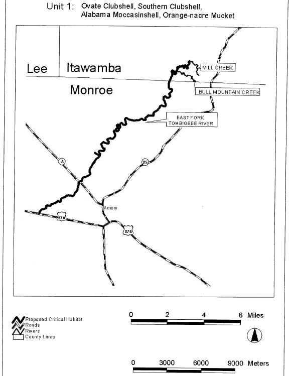
(iv) Unit 2. Bull Mountain Creek, Itawamba County, Mississippi. This is a critical habitat unit for the ovate clubshell, southern clubshell, Alabama moccasinshell, and orange-nacre mucket.
(A) Unit 2 includes the main stem of Bull Mountain Creek from Mississippi Highway 25 (T11S R9E S30), upstream to U.S. Highway 78 (T10S R10E S6), Itawamba County, Mississippi.
(B) Map of Unit 2 follows:
Start Printed Page 40122
Start Printed Page 40123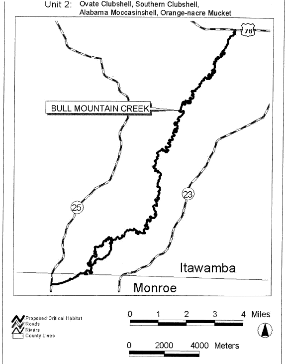
(v) Unit 3. Buttahatchee River and Sipsey Creek, Lowndes/Monroe County, Mississippi; Lamar County, Alabama. This is a critical habitat unit for the ovate clubshell, southern clubshell, Alabama moccasinshell, and orange-nacre mucket.
(A) Unit 3 includes the Buttahatchee River main stem from its confluence with the impounded waters of Columbus Lake (Tombigbee River, T16S R19W S23), Lowndes/Monroe County, Mississippi, upstream to the confluence of Beaver Creek (T13S R15W S17), Lamar County, Alabama; and Sipsey Creek, from its confluence with the Buttahatchee River (T14S R17W S2), upstream to the Mississippi/Alabama State Line (T12S R10E S21), Monroe County, Mississippi.
(B) Map of Unit 3 follows:
Start Printed Page 40124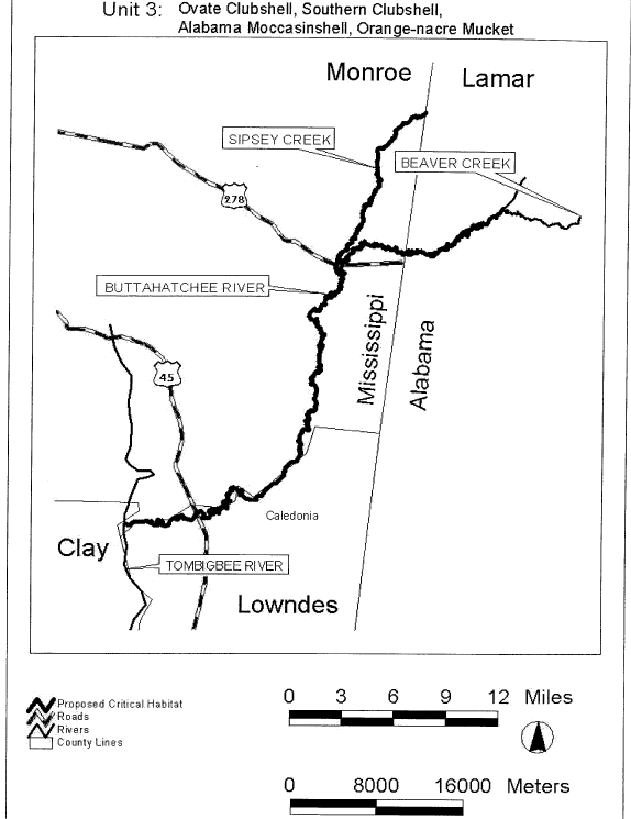
(vi) Unit 4. Luxapalila Creek and Yellow Creek, Lowndes County, Mississippi; Lamar County, Alabama. This is a critical habitat unit for the ovate clubshell, southern clubshell, Start Printed Page 40125Alabama moccasinshell, and orange-nacre mucket.
(A) Unit 4 includes the Luxapalila Creek main stem from Waterworks Road (T18S R18W S11), Columbus, Mississippi, upstream to approximately 1.0 km (0.6 mi) above Steens Road (T17S R17W S27), Lowndes County, Mississippi; and the Yellow Creek main stem from its confluence with Luxapalila Creek (T17S R17W S21), Lowndes County, Mississippi, upstream to the confluence of Cut Bank Creek (T16S R16W S30), Lamar County, Alabama.
(B) Map of Unit 4 follows:
Start Printed Page 40126
Start Printed Page 40127
(vii) Unit 5. Coalfire Creek, Pickens County, Alabama. This is a critical habitat unit for the ovate clubshell, southern clubshell, Alabama moccasinshell, and orange-nacre mucket.
(A) Unit 5 includes the Coalfire Creek main stem from its confluence with the impounded waters of Aliceville Lake (Tombigbee River, T20S R17W S26), upstream to U.S. Highway 82 (T19S R15W S15), Pickens County, Alabama.
(B) Map of Unit 5 follows:
Start Printed Page 40128
Start Printed Page 40129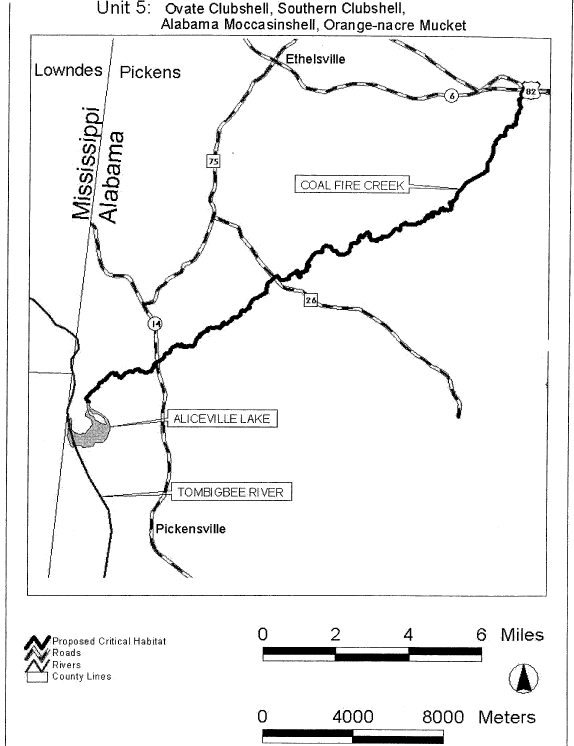
(viii) Unit 6. Lubbub Creek, Pickens County, Alabama. This is a critical habitat unit for the ovate clubshell, southern clubshell, Alabama moccasinshell, and orange-nacre mucket.
(A) Unit 6 includes the main stem of Lubbub Creek from its confluence with the impounded waters of Gainesville Lake (Tombigbee River, T24N R2W S11), upstream to the confluence of Little Lubbub Creek (T21S R1W S34), Pickens County, Alabama.
(B) Map of Unit 6 follows:
Start Printed Page 40130
Start Printed Page 40131
(ix) Unit 7. Sipsey River, Greene/Pickens, Tuscaloosa Counties, Alabama. This is a critical habitat unit for the ovate clubshell, southern clubshell, Alabama moccasinshell, and orange-nacre mucket.
(A) Unit 7 includes the Sipsey River main stem from its confluence with impounded waters of Gainesville Lake (Tombigbee River, T24N R1W S30), Greene/Pickens County, upstream to Alabama Highway 171 crossing (T18S R12W S34), Tuscaloosa County, Alabama.
(B) Map of Unit 7 follows:
Start Printed Page 40132
Start Printed Page 40133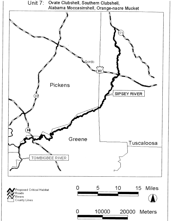
(x) Unit 8. Trussels Creek, Greene County, Alabama. This is a critical habitat unit for the ovate clubshell, southern clubshell, Alabama moccasinshell, and orange-nacre mucket.
(A) Unit 8 includes the Trussels Creek main stem from its confluence with the impounded waters of Demopolis Lake (Tombigbee River, T21N R2W S15), upstream to Alabama Highway 14 (T22N R1E S4), Greene County, Alabama.
(B) Map of Unit 8 follows:
Start Printed Page 40134
Start Printed Page 40135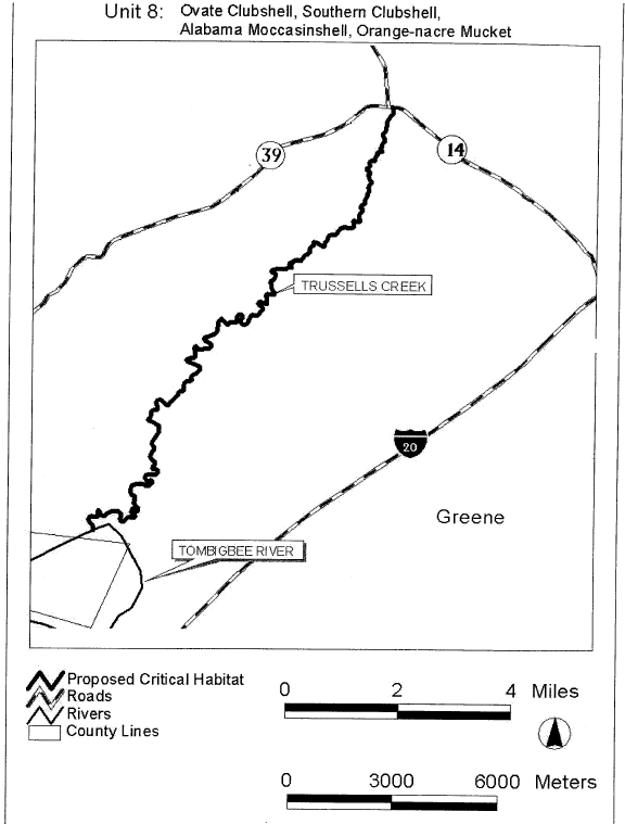
(xi) Unit 9. Sucarnoochee River, Sumter County, Alabama. This is a critical habitat unit for the ovate clubshell, southern clubshell, Alabama moccasinshell, and orange-nacre mucket.
(A) Unit 9 includes the Sucarnoochee River main stem from its confluence with the Tombigbee River (T17N R1W S26), upstream to the Mississippi/Alabama State Line (T19N R4W S15), Sumter County, Alabama.
(B) Map of Unit 9 follows:
Start Printed Page 40136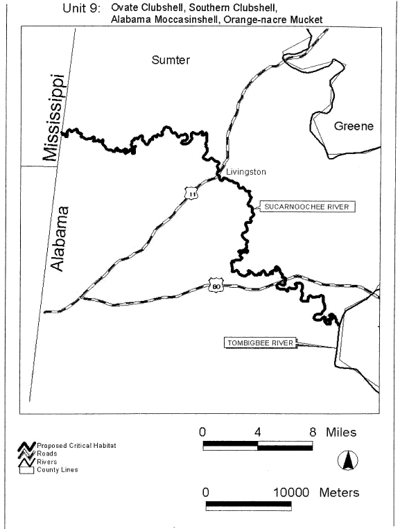
(xii) Unit 10. Sipsey Fork and tributaries, Winston, Lawrence Counties, Alabama. This is a critical habitat unit for the ovate clubshell, triangular kidneyshell, Alabama Start Printed Page 40137moccasinshell, orange-nacre mucket, and dark pigtoe.
(A) Unit 10 includes the Sipsey Fork main stem from the section 11/12 line (T10S R8W), Winston County, Alabama, upstream to the confluence of Hubbard Creek (T8S R9W S27), Lawrence County, Alabama; Thompson Creek, from its confluence with Hubbard Creek (T8S R9W S27), upstream to section 2 line (T8S R9W) Lawrence County; Brushy Creek, from the confluence of Glover Creek (T10S R7W S11), Winston County, upstream to section 9 (T8S R7W), Lawrence County; Capsey Creek, from confluence with Brushy Creek (T9S R7W S23), Winston County, upstream to the confluence of Turkey Creek (T8S R6W S33), Lawrence County; Rush Creek, from confluence with Brushy Creek (T9S R7W S15), upstream to Winston/Lawrence County Line (T9S R7W S1), Winston County; Brown Creek, from confluence with Rush Creek (T9S R7W S2), Winston County, upstream to section 24 line (T8S R7W), Lawrence County; Beech Creek, from confluence with Brushy Creek (T9S R7W S8), to confluence of East and West Forks (T9S R7W S6), Winston County; Caney Creek and North Fork Caney Creek, from confluence with Sipsey Fork (T9S R8W S28), upstream to section 14 line (T9S R9W), Winston County; Borden Creek, from confluence with Sipsey Fork (T8S R8W S5), Winston County, upstream to the confluence of Montgomery Creek (T8S R8W S10), Lawrence County; and Flannagin Creek, from confluence with Borden Creek (T8S R8W S28), upstream to confluence of Dry Creek (T8S R8W S4), Lawrence County.
Start Printed Page 40138
Start Printed Page 40139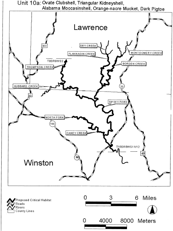
Start Printed Page 40140
(xiii) Unit 11. North River and Clear Creek, Tuscaloosa, Fayette Counties, Alabama. This is a critical habitat unit for the ovate clubshell, triangular kidneyshell, Alabama moccasinshell, orange-nacre mucket, and dark pigtoe.
(A) Unit 11 includes the main stem of the North River from Tuscaloosa County Road 38 (T18S R10W S16), Tuscaloosa County, upstream to confluence of Ellis Creek (T16S R10W S6), Fayette County, Alabama; and Clear Creek from its confluence with North River (T16S R11W S13) to Bays Lake Dam (T16S R11W S2), Fayette County, Alabama.
(B) Map of Unit 11 follows:
Start Printed Page 40141
Start Printed Page 40142
(xiv) Unit 12. Locust Fork and Little Warrior Rivers, Jefferson, Blount Counties, Alabama. This is a critical habitat unit for the ovate clubshell, upland combshell, triangular kidneyshell, Alabama moccasinshell, orange-nacre mucket, and dark pigtoe.
(A) Unit 12 includes the Locust Fork main stem from U.S. Highway 78 (T15S R4W S30), Jefferson County, upstream to the confluence of Little Warrior River (T13S R1W S3), Blount County, Alabama; and Little Warrior River from its confluence with the Locust Fork (T13S R1W S3), upstream to the confluence of Calvert Prong and Blackburn Fork (T13S R1W S12), Blount County, Alabama.
(B) Map of Unit 12 follows:
Start Printed Page 40143
Start Printed Page 40144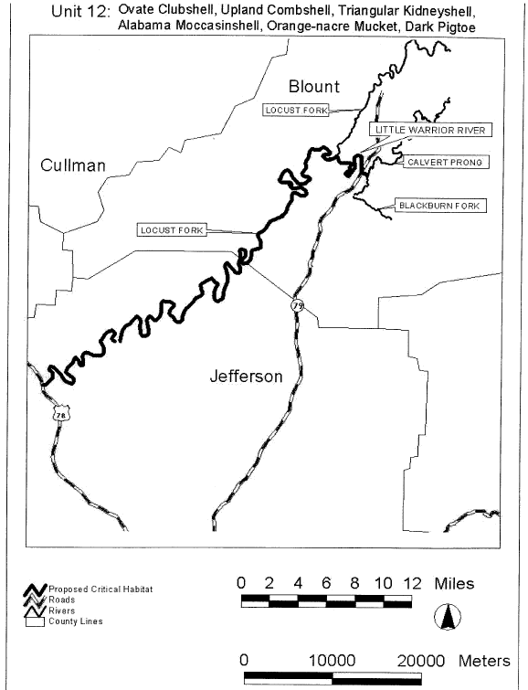
(xv) Unit 13. Cahaba River and Little Cahaba River, Jefferson, Shelby, Bibb Counties, Alabama. This is a critical habitat unit for the southern acornshell, ovate clubshell, southern clubshell, upland combshell, triangular kidneyshell, Alabama moccasinshell, orange-nacre mucket, and fine-lined pocketbook.
(A) Unit 13 includes the Cahaba River from U.S. Highway 82 (T23N R9E S26), Centerville, Bibb County, upstream to Jefferson County Road 143 (T18S R1E S33), Jefferson County, Alabama; and the Little Cahaba River from its confluence with the Cahaba River (T24N R10E S21), upstream to the confluence of Mahan and Shoal Creeks (T24N R11E S14), Bibb County, Alabama.
(B) Map of Unit 13 follows:
Start Printed Page 40145
Start Printed Page 40146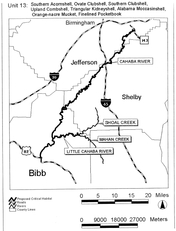
(xvi) Unit 14. Alabama River, Autauga, Lowndes, Dallas Counties, Alabama. This is a critical habitat unit for the southern clubshell and orange-nacre mucket.
(A) Unit 14 includes the Alabama River from the confluence of the Cahaba River (T16N R10E S32), Dallas County, upstream to the confluence of Big Swamp Creek (T15N R12E S1), Lowndes County, Alabama.
(B) Map of Unit 14 follows:
Start Printed Page 40147
Start Printed Page 40148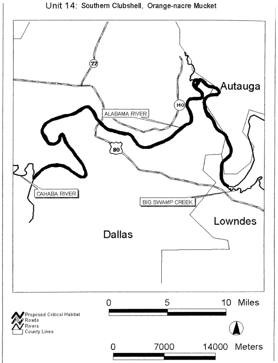
(xvii) Unit 15. Bogue Chitto Creek, Dallas County, Alabama. This is a critical habitat unit for the southern clubshell, Alabama moccasinshell, and orange-nacre mucket.
(A) Unit 15 includes the Bogue Chitto Creek main stem from its confluence with the Alabama River (T14N R8E S24), Dallas County, upstream to U.S. Highway 80 (T17N R7E S24), Dallas County, Alabama.
(B) Map of Unit 15 follows:
Start Printed Page 40149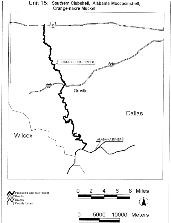
(xviii) Unit 16. Tallapoosa River, Cleburne County, Alabama, and Paulding, Haralson Counties, Georgia; Cane Creek, Cleburne County, Alabama. This is a critical habitat unit for the fine-lined pocketbook. Start Printed Page 40150
(A) Unit 16 includes the main stem Tallapoosa River from U.S. Highway 431 (T17S R10E S31), Cleburne County, Alabama, upstream to the confluence of McClendon and Mud Creeks (33 °50′ 43″ N 85 °00′45″W), Paulding County, Georgia; and Cane Creek from its confluence with Tallapoosa River (T16S R10E S24), upstream to section 33/4 Line (T15S, R11E), Cleburne County, Alabama.
(B) Map of Unit 16 follows:
Start Printed Page 40151
Start Printed Page 40152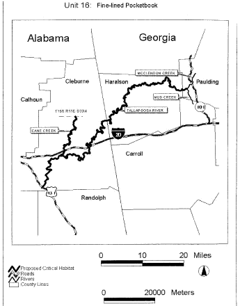
(xix) Unit 17. Uphapee, Choctafaula, and Chewacla Creeks, Macon, Lee Counties, Alabama. This is a critical habitat unit for the ovate clubshell, southern clubshell, and fine-lined pocketbook.
(A) Unit 17 includes the mainstem of Uphapee Creek from Alabama Highway 199 (T17N R23E S3), upstream to the confluence of Opintlocco and Chewacla Creeks (T17N R24E S26), Macon County, Alabama; Choctafaula Creek, from confluence with Uphapee Creek (T17N R24E S8), upstream to Macon County Road 54 (T18N R 25E S31), Macon County, Alabama; Chewacla Creek, from confluence with Opintlocco Creek (T17N R24E S26), Macon County, Alabama, upstream to Lee County Road 159 (T18N R26E S18), Lee County, Alabama; Opintlocco Creek, from confluence with Chewacla Creek (T17N R24E S26), upstream to Macon County Road 79 (T16N R25E S25) Macon County, Alabama.
(B) Map of Unit 17 follows:
Start Printed Page 40153
Start Printed Page 40154
(xx) Unit 18. Coosa River (Old River Channel) and Terrapin Creek, Cherokee, Calhoun, Cleburne Counties, Alabama. This is a critical habitat unit for the southern acornshell, ovate clubshell, southern clubshell, upland combshell, triangular kidneyshell, Coosa moccasinshell, southern pigtoe, and fine-lined pocketbook.
(A) Unit 18 includes the Coosa River main stem from the power line crossing southeast of Maple Grove, Alabama (T10S R8E S35), upstream to Weiss Dam (T10S R8E S13), Cherokee County, Alabama; Terrapin Creek, 53 km (33 mi) extending from its confluence with the Old Coosa River channel (T10S R9E S28), Cherokee County, upstream to Cleburne County Road 49 (T13S R11E S15), Cleburne County, Alabama; South Fork Terrapin Creek, 7 km (4 mi), from its confluence with Terrapin Creek (T13S R11E S18), upstream to Cleburne County Road 55 (T13S R11E S30), Cleburne County, Alabama.
(B) Map of Unit 18 follows:
Start Printed Page 40155
Start Printed Page 40156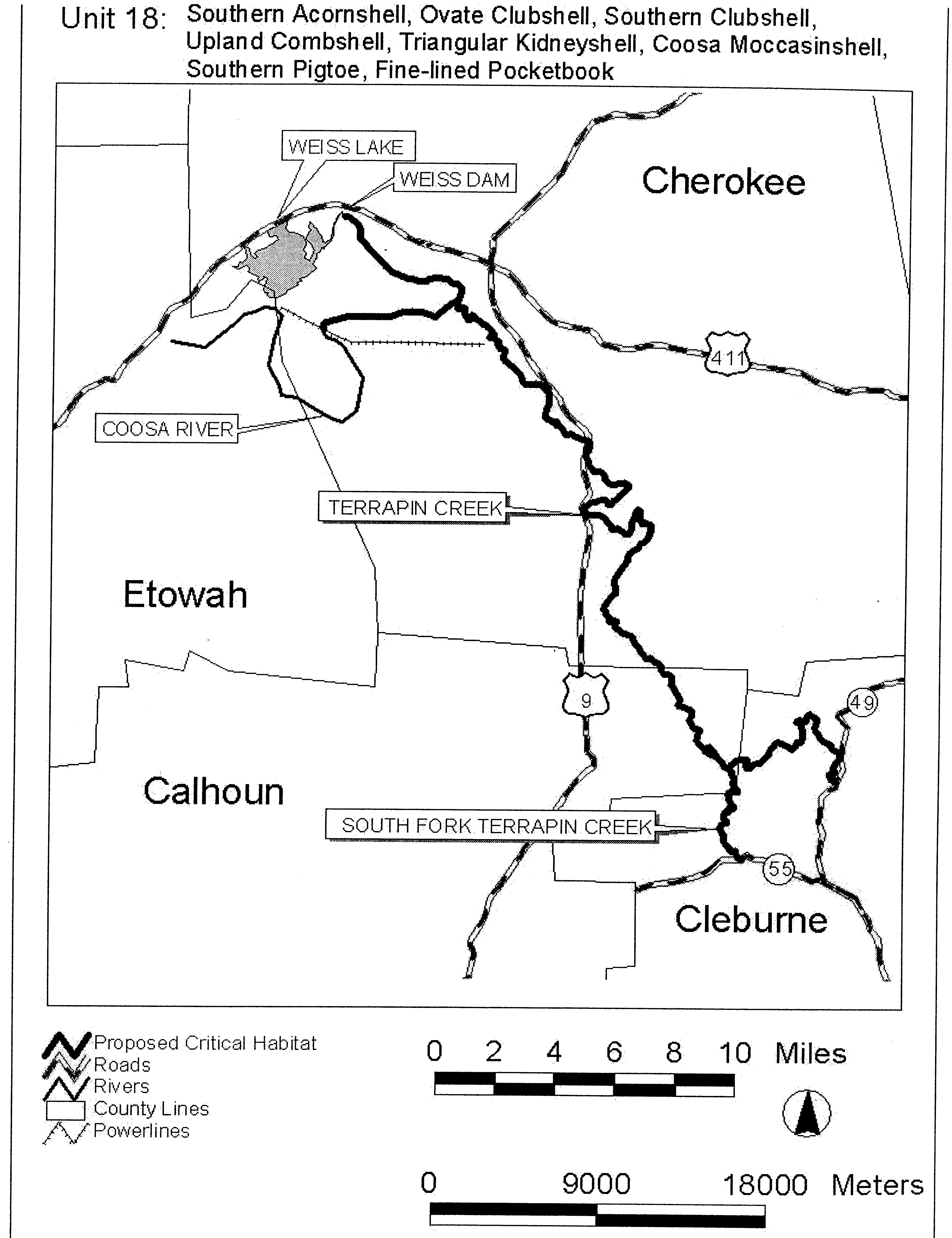
(xxi) Unit 19. Hatchet Creek, Coosa, Clay Counties, Alabama. This is a critical habitat unit for the southern acornshell, ovate clubshell, southern clubshell, upland combshell, triangular kidneyshell, Coosa moccasinshell, southern pigtoe, and fine-lined pocketbook.
(A) Unit 19 includes the main stem of Hatchet Creek from the confluence of Swamp Creek at Coosa County Road 29 (T22N R17E S26), Coosa County, Alabama, upstream to Clay County Road 4 (T22S R6E S17) Clay County, Alabama.
(B) Map of Unit 19 follows:
Start Printed Page 40157
Start Printed Page 40158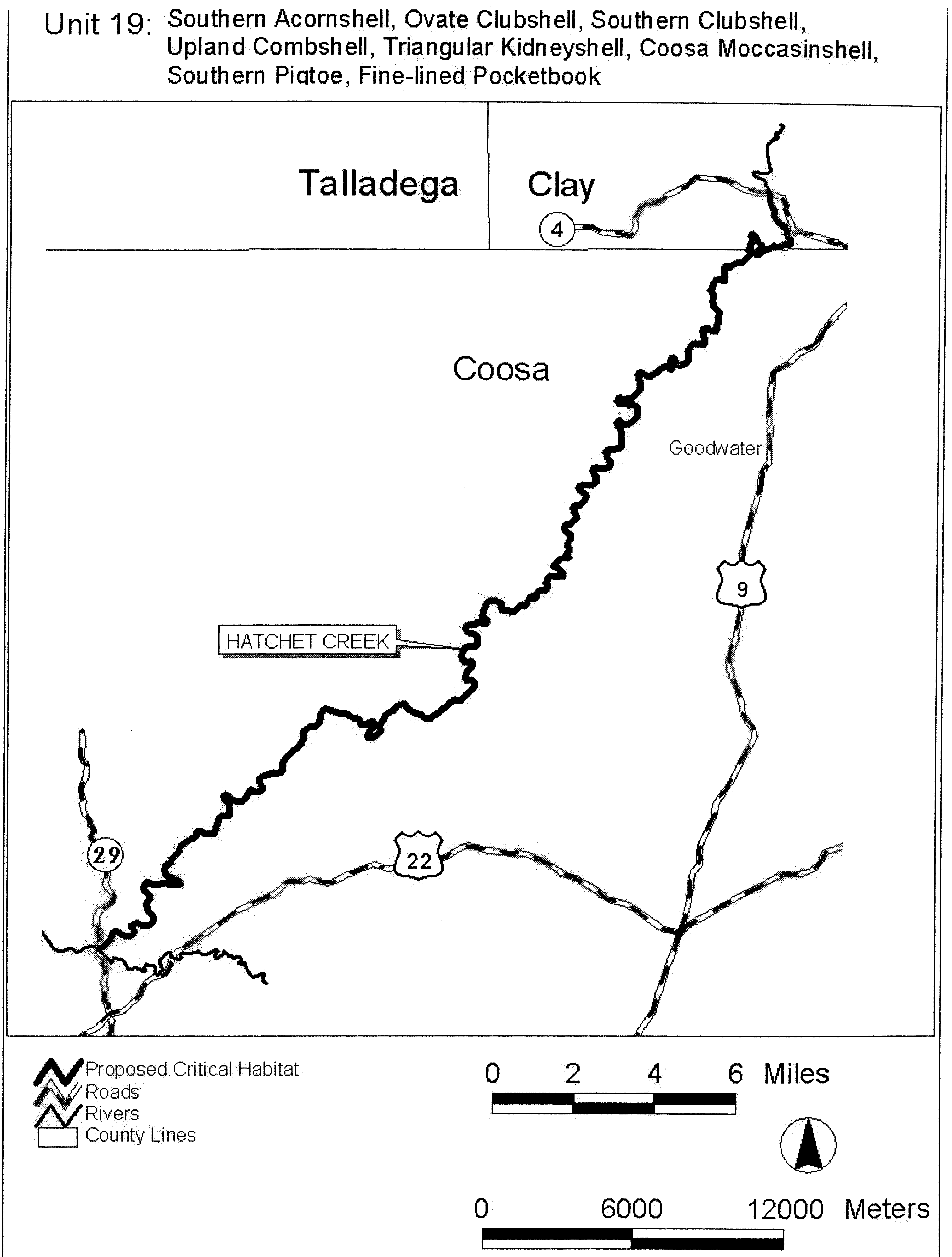
(xxii) Unit 20. Shoal Creek, Calhoun, Cleburne Counties, Alabama. This is a critical habitat unit for the triangular kidneyshell, Coosa moccasinshell, southern pigtoe, and fine-lined pocketbook.
(A) Unit 20 includes the main stem of Shoal Creek from the headwater of Whitesides Mill Lake (T15S R9E S12), Calhoun County, Alabama, upstream to the tailwater of Coleman Lake Dam (T14S R10E S26), Cleburne County, Alabama.
(B) Map of Unit 20 follows:
Start Printed Page 40159
Start Printed Page 40160
(xxiii) Unit 21. Kelly Creek and Shoal Creek, Shelby, St. Clair Counties, Alabama. This is a critical habitat unit for the southern acornshell, ovate clubshell, southern clubshell, upland combshell, triangular kidneyshell, Coosa moccasinshell, southern pigtoe, and fine-lined pocketbook.
(A) Unit 21 includes the Kelly Creek main stem extending from the confluence with the Coosa River (T19S R3E S5), upstream to the confluence of Shoal Creek (T17S R2E S28), St. Clair County, Alabama; and the main stem of Shoal Creek from the confluence with Kelly Creek (T17S R2E S28), St. Clair County, Alabama, upstream to the St. Clair/Shelby County Line (T17S R2E S30), St. Clair County, Alabama.
(B) Map of Unit 21 follows:
Start Printed Page 40161
(xxiv) Unit 22. Cheaha Creek, Talladega, Clay Counties, Alabama. This is a critical habitat unit for the triangular kidneyshell, Coosa moccasinshell, southern pigtoe, and fine-lined pocketbook. Start Printed Page 40162
(A) Unit 22 includes the main stem of Cheaha Creek from its confluence with Choccolocco Creek (T17S R6E S19), Talladega County, Alabama, upstream to the tailwater of Chinnabee Lake Dam (T18S R7E S14), Clay County, Alabama.
(B) Map of Unit 22 follows:
Start Printed Page 40163
Start Printed Page 40164
(xxv) Unit 23. Yellowleaf Creek and Mud Creek, Shelby County, Alabama. This is a critical habitat unit for the triangular kidneyshell, Coosa moccasinshell, southern pigtoe, and fine-lined pocketbook.
(A) Unit 23 includes the Yellowleaf Creek main stem from Alabama Highway 25 (T20S R2E S29), upstream to Shelby County Road 49 (T20S R1W S13); and the Muddy Prong main stem extending from its confluence with Yellowleaf Creek (T20S R1E S1), upstream to U.S. Highway 280 (T19S R1E S28), Shelby County, Alabama.
(B) Map of Unit 23 follows:
Start Printed Page 40165
Start Printed Page 40166
(xxvi) Unit 24. Big Canoe Creek, St. Clair County, Alabama. This is a critical habitat unit for the southern acornshell, ovate clubshell, southern clubshell, upland combshell, triangular kidneyshell, Coosa moccasinshell, southern pigtoe, and fine-lined pocketbook.
(A) Unit 24 includes the main stem of Big Canoe Creek from its confluence with Little Canoe Creek at the St. Clair/Etowah County line (T13S R5E S17), St. Clair County, upstream to the confluence of Fall Branch (T14S R1E S28) St. Clair County, Alabama.
(B) Map of Unit 24 follows:
Start Printed Page 40167
(xxvii) Unit 25. Oostanaula, Coosawattee, and Conasauga Rivers, and Holly Creek, Floyd, Gordon, Whitfield, Murray Counties, Georgia; Bradley, Polk Counties, Tennessee. This is a critical habitat unit for the southern acornshell, Start Printed Page 40168ovate clubshell, southern clubshell, upland combshell, triangular kidneyshell, Alabama moccasinshell, Coosa moccasinshell, southern pigtoe, and fine-lined pocketbook.
(A) Unit 25 includes the Oostanaula River main stem from its confluence with the Etowah River, Floyd County, Georgia (34°15′13″ N, 85°10′35″ W), upstream to the confluence of the Conasauga and Coosawattee River, Gordon County, Georgia (34°32′32″ N, 84°54′12 ″ W); the Coosawattee River main stem from its confluence with the Conasauga River (34°32′32 ″ N, 84°54′12 ″ W), upstream to Georgia State Highway 136, Gordon County, Georgia (34°36′49 ″ N, 84°46′43 ″ W); the Conasauga River main stem from confluence with the Coosawattee River (34°32′32 ″ N, 84°54′13 ″ W), Gordon County, Georgia, upstream through Bradley and Polk Counties, Tennessee, to Murray County Road 2 (34°58′27 ″ N, 84°38′43 ″ W), Murray County, Georgia; and the mainstem of Holly Creek from its confluence with the Conasauga River (34°42′12 ″ N, 84°53′29 ″ W), upstream to its confluence with Rock Creek, Murray County, Georgia (34°46′59 ″ N, 84°45′25 ″ W).
(B) Map of Unit 25 follows:
Start Printed Page 40169
Start Printed Page 40170
(xxviii) Unit 26. Lower Coosa River, Elmore County, Alabama. This is a critical habitat unit for the southern acornshell, ovate clubshell, southern clubshell, upland combshell, triangular kidneyshell, Alabama moccasinshell, Coosa moccasinshell, southern pigtoe, and fine-lined pocketbook.
(A) Unit 26 includes the Coosa River main stem from Alabama State Highway 111 bridge (T18N R18/19E S24/19), upstream to Jordan Dam (T19N R18E S22), Elmore County, Alabama.
(B) Map of Unit 26 follows:
Start Printed Page 40171 * * * * *End Signature End Supplemental Information
Dated: June 17, 2004.
Craig Manson,
Assistant Secretary, Fish, Wildlife, and Parks.
BILLING CODE 4310-55-P
BILLING CODE 4310-55-C
BILLING CODE 4310-55-P
[FR Doc. 04-14279 Filed 6-30-04; 8:45 am]
BILLING CODE 4310-55-C


Document Information
- Effective Date:
- 8/2/2004
- Published:
- 07/01/2004
- Department:
- Fish and Wildlife Service
- Entry Type:
- Rule
- Action:
- Final rule.
- Document Number:
- 04-14279
- Dates:
- This rule is effective August 2, 2004.
- Pages:
- 40083-40171 (89 pages)
- RINs:
- 1018-AI73: Endangered and Threatened Wildlife and Plants; Designation of Critical Habitat for 11 Mobile River Basin Freshwater Mussels
- RIN Links:
- https://www.federalregister.gov/regulations/1018-AI73/endangered-and-threatened-wildlife-and-plants-designation-of-critical-habitat-for-11-mobile-river-ba
- Topics:
- Endangered and threatened species, Exports, Imports, Reporting and recordkeeping requirements, Transportation
- PDF File:
- 04-14279.pdf
- CFR: (2)
- 50 CFR 17.11
- 50 CFR 17.95