-
Start Preamble
AGENCY:
Federal Aviation Administration (FAA), DOT.
ACTION:
Notice of proposed rulemaking (NPRM).
SUMMARY:
This action proposes to modify the Detroit, MI, Class B airspace area to contain aircraft conducting published instrument procedures at Detroit Metropolitan Wayne County Airport (DTW), Detroit, MI, within Class B airspace. The FAA is taking this action to support all three existing Simultaneous Instrument Landing System (SILS) configurations today, runways 22/21, runways 4/3 and runways 27L/27R, as well as support aircraft containment for triple SILS operations planned for the very near future for runways 4L/4R/3R and runways 21L/22L/22R. This action would enhance safety, improve the flow of air traffic, and reduce the potential for midair collisions in the DTW terminal area, while accommodating the concerns of airspace users. Further, this effort supports the FAA's national airspace redesign goal of optimizing terminal and enroute airspace areas to reduce aircraft delays and improve system capacity.
DATES:
Comments must be received on or before October 15, 2012.
ADDRESSES:
Send comments on this proposal to the U.S. Department of Transportation, Docket Operations, M-30, 1200 New Jersey Avenue SE., West Building Ground Floor, Room W12-140, Washington, DC 20590-0001; telephone: (202) 366-9826. You must identify FAA Docket No. FAA-2012-0661 and Airspace Docket No. 09-AWA-4 at the beginning of your comments. You may also submit comments through the Internet at http://www.regulations.gov.
Start Further InfoFOR FURTHER INFORMATION CONTACT:
Colby Abbott, Airspace, Regulations and ATC Procedures, Office of Airspace Services, Federal Aviation Administration, 800 Independence Avenue SW., Washington, DC 20591; telephone: (202) 267-8783.
End Further Info End Preamble Start Supplemental InformationSUPPLEMENTARY INFORMATION:
Comments Invited
Interested parties are invited to participate in this proposed rulemaking by submitting such written data, views, or arguments as they may desire. Comments that provide the factual basis supporting the views and suggestions presented are particularly helpful in developing reasoned regulatory decisions on the proposal. Comments are specifically invited on the overall regulatory, aeronautical, economic, environmental, and energy-related aspects of the proposal.
Communications should identify both docket numbers (FAA Docket No. FAA-2012-0661 and Airspace Docket No. 09-AWA-4) and be submitted in triplicate to the Docket Management Facility (see “ADDRESSES” section for address and phone number). You may also submit comments through the Internet at http://www.regulations.gov.
Commenters wishing the FAA to acknowledge receipt of their comments on this action must submit with those comments a self-addressed, stamped postcard on which the following statement is made: “Comments to Docket Nos. FAA-2012-0661 and Airspace Docket No. 09-AWA-4.” The Start Printed Page 48477postcard will be date/time stamped and returned to the commenter.
All communications received on or before the specified closing date for comments will be considered before taking action on the proposed rule. The proposal contained in this action may be changed in light of comments received. All comments submitted will be available for examination in the public docket both before and after the closing date for comments. A report summarizing each substantive public contact with FAA personnel concerned with this rulemaking will be filed in the docket.
Availability of NPRMs
An electronic copy of this document may be downloaded through the Internet at http://www.regulations.gov. Recently published rulemaking documents can also be accessed through the FAA's Web page at http://www.faa.gov/regulations_policies/rulemaking/recently_published/.
You may review the public docket containing the proposal, any comments received and any final disposition in person in the Dockets Office (see “ADDRESSES” section for address and phone number) between 9:00 a.m. and 5.00 p.m., Monday through Friday, except Federal holidays. An informal docket may also be examined during normal business hours at the office of the Central Service Center, Operations Support Group, Federal Aviation Administration, 2601 Meacham Blvd. Fort Worth, TX 76137.
Persons interested in being placed on a mailing list for future NPRMs should contact the FAA's Office of Rulemaking, (202) 267-9677, for a copy of Advisory Circular No. 11-2A, Notice of Proposed Rulemaking Distribution System, which describes the application procedure.
Background
In 1974, the FAA issued a final rule which established the Detroit, MI (Metropolitan Wayne County Airport), Terminal Control Area (TCA) (39 FR 11085). The Detroit TCA airspace, renamed Class B airspace in 1993, has been altered three times since being established. The first modification was in 1975 (40 FR 12253) to redefine certain lateral boundaries and floor altitudes in the vicinity of the Detroit River. The second modification was in 1985 (50 FR 37994) to redefine lateral boundaries for containing aircraft conducting SILS approaches as a result of the addition of Runway 3R/21L. And the last modification was accomplished in 1987 (52 FR 4893) to redefine lateral boundaries for containing aircraft conducting instrument approaches to Runway 21R and two instrument approaches to Runway 27. There have been no airspace modifications to the Detroit Class B airspace since 1987.
As a result of the Airspace Reclassification final rule (56 FR 65638), which became effective in 1993, the terms “terminal control area” and “airport radar service area” were replaced by “Class B airspace area,” and “Class C airspace area,” respectively. The primary purpose of a Class B airspace area is to reduce the potential for midair collisions in the airspace surrounding airports with high density air traffic operations by providing an area in which all aircraft are subject to certain operating rules and equipment requirements. FAA directives require Class B airspace areas be designed to contain all instrument procedures, and that air traffic controllers vector aircraft as appropriate to remain within Class B airspace after entry.
In 1985, the Detroit TCA airspace was modified to accommodate SILS procedures as the primary instrument approach configuration to meet demand at that time. These procedures today require that the aircraft be established on final approach course no less than 17 miles from the runway. This forces the traffic pattern out of the lateral limits of the Class B airspace to the northeast, when landing runways 22/21, and to the southwest, when landing runways 4/3, by a minimum of five miles in both directions.
In 1987, the last modification to the Detroit TCA airspace was accomplished to contain aircraft flying instrument approaches to runway 21R and runway 27. In 1993, runway 27L opened at DTW allowing SILS approaches to be flown when on a west flow. The associated traffic patterns for the SILS approaches once again extended 5 to 10 miles beyond the lateral limits of today's Class B airspace design. In 2001, runway 22R was opened at DTW with no modification to the Class B airspace for containing aircraft flying the new final approach courses extending beyond the Class B airspace boundary to the west. As a result of opening runway 22R and creating a third parallel Instrument Landing System (ILS) approach, the associated SILS procedures required aircraft to be established on final approach course between 19 and 21 miles from the runways. The new runway procedures caused the associated traffic patterns to be extended further as well.
Since the Detroit Class B airspace area was last modified in 1987, DTW has experienced increased traffic levels, expanding operational requirements, a considerably different fleet mix, and airport infrastructure improvements enabling simultaneous instrument approach procedures to multiple parallel runway combinations. For calendar year 2010, DTW ranked number 12 in the list of the “50 Busiest FAA Airport Traffic Control Towers,” with 453,000 operations (an increase of 20,000 from the previous year), and number 18 in the list of the “50 Busiest Radar Approach Control Facilities,” with 590,000 instrument operations (an increase of 30,000 from the previous year). Additionally, the calendar year 2010 passenger enplanement data ranked DTW as number A14 among Commercial Service Airports, with A14,643,890 passenger enplanements (an increase of 2.84% from the previous year).
The FAA has determined that it is not possible to modify current procedures to contain arrival aircraft conducting simultaneous instrument approaches to the existing parallel runways within the Detroit Class B airspace area. As the capacity increases, the number of aircraft exiting the Class B airspace also increases. With the current Class B airspace configuration, arriving aircraft routinely enter, exit, and then reenter Class B airspace while flying published instrument approach procedures, contrary to FAA directives. The procedural requirements for establishing aircraft on the final approach course to conduct simultaneous approaches to the existing parallel runways has resulted in aircraft exceeding the lateral boundaries of the Class B airspace by up to 5 to 10 miles during moderate levels of air traffic. Modeling of existing and projected traffic flows has shown that the proposed expanded Class B airspace would enhance flight safety by containing all instrument approach procedures and associated traffic patterns within the boundaries of the Class B airspace, support increased operations to the current and planned parallel runways, and better segregate the IFR aircraft arriving/departing DTW and the VFR aircraft operating in the vicinity of the Detroit Class B airspace. The proposed Class B airspace modifications described in this NPRM are intended to address these issues.
Pre-NPRM Public Input
In 2009, the FAA took action to form an Ad hoc Committee to provide recommendations for the FAA to consider in designing a proposed modification to the Detroit Class B airspace area. The Michigan Department of Transportation Aviation Programs Office chaired the group with participants including representatives from Eastern Michigan University, Start Printed Page 48478Monroe Aviation, University of Michigan Flyers, Wayne County Airport Authority, U.S. Coast Guard Air Station Detroit, OAM CBP Detroit, Plymouth Mettetal Airport, Dearborn Flying Club, Civil Air Patrol, 127th Wing Selfridge ANGB, Dawn Patrol Flying Club—Mettetal Airport, Aircraft Owners and Pilots Association (AOPA), Michigan Business Aircraft Association, Skydive Tecumseh, Adrian Soaring Club, and Kalitta Charters. The Airlines Pilots Association (ALPA) was inadvertently left off the invitation, but was able to provide input later. Three Ad hoc Committee meetings were held on November 12, 2009; December 10, 2009; and February 19, 2010. Although the Ad hoc Committee did not reach consensus on any airspace design recommendations, the participants offered a number of comments for consideration.
In addition, as announced in the Federal Register of May 13, 2010 (75 FR 11496), three informal airspace meetings were held; the first on July 20, 2010, at the Troy, MI, Holiday Inn; the second on July 21, 2010, at the Ypsilanti, MI, campus of the Eastern Michigan University; and the third on July 22, 2010, at the Monroe, MI, Holiday Inn Express. These meetings provided interested airspace users with an opportunity to present their views and offer suggestions regarding the planned modifications to the Detroit Class B airspace area. All substantive comments received as a result of the informal airspace meetings, along with the comments and recommendations offered by the Ad hoc Committee were considered in developing this proposal.
Discussion of Ad Hoc Committee Recommendations and Comments
As a starting point for discussions, a preliminary Class B design was presented to the Ad hoc Committee for review. In general, the preliminary design consisted of lower Class B floors within portions of existing Class B airspace and expansion of the Class B airspace area to a 30 nautical mile (NM) radius of the Detroit (DXO) VOR/DME antenna as opposed to the current 20 NM configuration centered on the Detroit ILS Localizer runway 4R (I-DTW) antenna.
The Ad hoc Committee agreed the current configuration of Detroit Class B airspace is antiquated and in need of revision to accommodate new runways, new approach procedures, and increased traffic. The Ad hoc Committee's report provided to the FAA for consideration regarding the proposed modification of the Detroit Class B airspace area contained numerous recommendations related to the Class B airspace design, raised by the committee participants.
The Ad hoc Committee recommended the ceiling of the Detroit Class B airspace remain at 8,000 feet MSL, arguing that raising the ceiling to 10,000 feet MSL would be more restrictive to aircraft overflying the Class B airspace area. They further offered there was no evidence provided that there are safety problems with the upper limit of the existing Detroit Class B.
The FAA believes raising the ceiling of the Class B airspace would enhance flight safety for all by better segregating the large turbine-powered aircraft and non-participating VFR aircraft that are currently operating in the vicinity of the Detroit Class B airspace area. Non-participating VFR aircraft would continue to have their choice of flying above or below the Class B airspace, or circumnavigating it, to remain clear should they decide not to contact Detroit Terminal Radar Approach Control (D21) to receive Class B services. When simultaneous triple ILS approaches are implemented in the future, aircraft assigned the middle runway would be held above the traffic going to the outboard runways. These aircraft would be vectored and delivered to the final controller at 9,000 feet MSL on downwind and at 8,000 feet MSL on base legs of the pattern to final approaches.
A portion of the Detroit Class B airspace configuration extends into Canadian airspace. For that portion of airspace, the U.S. Class B airspace equivalent would be established by NAV CANADA as Canadian “Class C” airspace to ensure the same ATC services and procedures are provided. NAV CANADA usually designates their Class C airspace with a ceiling at 12,500 feet MSL, and supports raising the Detroit Class B/Class C airspace ceiling to 10,000 feet MSL, but objects to keeping the ceiling at 8,000 feet MSL. Canadian regulations do not have an equivalent requirement to the FAA's Mode C veil (Mode C transponder use required within 30 NM of Class B primary airports); however, Canadian regulations do require transponder use above 10,000 feet MSL in radar controlled airspace. As such, NAV CANADA strongly advocates against a modified Class B/Class C airspace configuration that would leave a 2,000-foot gap in transponder requirements between the ceiling of the Class B/Class C configuration and the 10,000 feet MSL regulatory transponder requirement in Canada.
The Ad hoc Committee recommended that the outer boundaries of the Class B airspace area should be limited to 25 NM and only to the north-northeast (NNE) and south-southwest (SSW) of Detroit where such extensions are necessary for containing the parallel SILS approaches and associated base leg and traffic pattern radar vectoring airspace.
The recommendation to limit the outer boundaries of the Class B proposal to 25 NM and then only to the NNE and SSW was not adopted. The proposed Class B airspace modifications were designed to ensure containment of current and future instrument procedures within Class B airspace with the minimum amount of airspace essential to control IFR aircraft arriving from multiple arrival streams being sequenced for SILS procedures into DTW. Aircraft conducting SILS approaches cannot be assigned the same altitude when being turned on to any of the three parallel final approach courses; they must be assigned altitudes that differ by a minimum of 1,000 feet. This, combined with straight flight requirements prior to final approach course interception, results in traffic patterns that are expected to routinely extend beyond 21 miles from the runway, at altitudes as low as 4,000 feet MSL in ideal conditions. During daily periods of greater than moderate air traffic demand, the patterns would extend beyond the suggested 25 NM boundary limit. Additionally, when DTW begins utilizing triple Precision Runway Monitoring (PRM) SILS approaches, the associated traffic patterns are expected to extend beyond a 25 NM boundary also. The traffic demand requirements for conducting SILS approaches; containing aircraft flying instrument procedures within Class B airspace, once entered; and realizing the safety benefits with segregating large turbine-powered aircraft and non-participating VFR aircraft operating in the vicinity of the Detroit Class B airspace necessitate expanding the Class B airspace as proposed.
The Ad hoc Committee noted that extending the Class B boundaries to 30 NM in all quadrants, as originally proposed, would have an adverse safety and economic impact on the outlying airports, glider activities, and parachuting operations. They recommended the western boundary of the Class B airspace area remain basically the same as the current Class B boundary. Also, if an extension at 4,000 feet MSL to the northeast was necessary, the Ad hoc Committee contends it should be evaluated for its effect on the Oakland-Troy Airport (VLL), Troy, MI.Start Printed Page 48479
In consideration of the recommendation, the FAA proposed a western boundary similar to that of today in part, but not in total, to enable arriving/departing aircraft to enter/exit the Class B airspace through the ceiling. The proposed Class B airspace area from the DXO 333° radial counterclockwise to the SVM 217° radial, west of the Ann Arbor (ARB) and Willow Run (YIP) airports, was removed from the original airspace configuration, and a proposed Class B airspace shelf between 25 NM and 30 NM southwest of DTW, was terminated east of the Tecumseh/Meyers-Divers (3TE) airport. While not strictly similar to the boundary of today, the change is responsive to the recommendation. Additionally, the FAA has determined the 4,000-foot MSL shelf proposed northeast of DTW is necessary and does not affect VLL operations occurring under the Class B airspace shelf. The proposed Class B airspace area represents the minimum airspace prudent to contain arriving/departing IFR aircraft while minimizing impact on other airspace users in the area, and enhancing flight safety to all by segregating large turbine-powered aircraft and the non-participating VFR aircraft operating in close proximity to DTW.
The Ad hoc Committee also recommended that Class B airspace floors overlying Class D airspace areas should only have one altitude and not reflect two different Class B floor altitudes overhead as was presented in the FAA's original Class B proposal over the Coleman A. Young Municipal Airport (DET), Detroit, MI, Class D airspace area. They stated a split altitude configuration could lead to confusion and potential violations.
The recommendation to establish a single Class B airspace floor altitude above Class D airspace was adopted at Ann Arbor Airport (ARB) (not mentioned by the Ad hoc Committee), but not adopted at DET. In response to the Ad hoc Committee's recommendation, the FAA reviewed the original Class B airspace design and modified the airspace design in the vicinity of ARB and DET airports. The portion of Class B airspace overhead ARB is proposed with a single 3,500-foot MSL floor. The Class B airspace overhead DET was redesigned so it does not encroach on the DET Class D airspace, and has a 3,500-foot MSL floor over the southwest half of the Class D airspace area and a 4,000-foot MSL floor over the northeast half of the Class D airspace area. The FAA believes that the amended proposal removes confusion and inadvertent incursions that could result from the infringement of Class B on Class D airspace.
The Ad hoc Committee noted the airspace along the Detroit River and the Lake Erie coastline west and south of Grosse Ile, below existing Class B airspace, provides a valuable uncharted VFR flyway for aircraft transiting the area northeast and southwest, as well as arriving and departing Grosse Ile (ONZ) airport. It recommended protecting that flyway with a 3,000-foot MSL ceiling by terminating the proposed boundary of the 2,500-foot MSL Class B airspace shelf closer to DTW. It also recommended the western boundary of the 3,000-foot MSL Class B airspace shelf located east of DTW be defined using Fort Street, the railroad tracks, or the highway as visual references (similar to the current Class B configuration) to maintain the ability to fly practice approaches at ONZ without the need for a Class B clearance, and to extend the area further west in the vicinity of the Ford Headquarters building. Lastly, the Ad hoc Committee recommended the FAA work with local pilots to establish VFR waypoints for this uncharted VFR flyway.
The FAA adopted the suggestion to terminate the 2,500-foot Class B airspace shelf closer to DTW. In fact, the southern radius of the 2,500-foot MSL shelf was reduced to a 10 NM arc of I-DTW, keeping the southern boundary of the proposed 2,500-foot MSL Class B airspace shelf near where it exists today. At the same time, the proposed radius of the Class B surface area south of DTW was reduced to an 8 NM arc of I-DTW. These adjustments allow easier access at the southern end of the river and allow practice approaches at ONZ to be flown without the need for a Class B clearance. The recommendation to retain I-75 as the western boundary of the 3,000-foot shelf in that area was not pursued because the FAA believes that sufficient visual references remain. Non-participating VFR aircraft transiting the uncharted flyway noted by the Ad hoc Committee may do so with visual reference to the eastern edge of ONZ and the western-most mainland shoreline at Wyandotte, MI. The FAA also agreed with the recommendation to extend the 3,000-foot MSL shelf north of ONZ, as well as further west in the vicinity of the Ford World Headquarters building, using visual reference (I-94) and DXO radial and distance information. The FAA will continue to work with local pilots to establish and chart VFR waypoints independent of this airspace action.
The Ad hoc Committee recommended the FAA maximize the efficiency of the airspace around DTW with a streamlined airspace design that does not envelop the large volume of airspace that was contained in the original modification configuration. For example, instead of 20-mile diameter circular areas around the airport, the FAA could consider “V” shaped corridors running northeast and southwest, funneling to the runways in both directions.
The FAA did not pursue the recommendation for establishing “V” shaped corridors extending northeast and southwest from DTW because there are departure and arrival flow configurations that run in an east and west alignment as well that would not be captured. To accommodate all the air traffic flows and associated downwind patterns for the various runway configurations, a “V” shaped configuration is not practical. Additionally, the air traffic control procedures necessary for safely breaking aircraft off final approach courses, when simultaneous approaches are in use, will require aircraft vectoring that would exceed the suggested design boundaries for containing large turbine-powered aircraft flying the approaches within Class B airspace.
The Ad hoc Committee recommended that the FAA make effective use of landmarks, like the interstate highways, to assist VFR pilots in non-GPS equipped aircraft to easily determine their position relative the Class B airspace boundaries.
The FAA agrees with the Ad hoc Committee's recommendation of using landmarks to assist VFR pilots in non-GPS equipped aircraft when there are easily identifiable landmarks that coincide with the proposed airspace configuration. In the cases where no easily identifiable landmarks are available or coincide with the configuration, the FAA uses ground-based navigation aid radials and distances. Fortunately, there are numerous landmarks depicted on the Detroit Terminal Area Chart that will be retained to assist VFR pilots. As noted previously, the FAA will continue to work with local pilots to define, establish, and chart appropriate VFR waypoints, independent of this airspace action.
The Ad hoc Committee commented that defining the Class B airspace configuration using a radial distance from a DME antenna from one of the DTW ILS systems in the initial modification proposal was unworkable for aircraft not specifically going into DTW. It recommended the airspace be defined by radial and distance information from the DTW airport reference point loaded in all Global Start Printed Page 48480Positioning System (GPS) and Long Range Navigation (LORAN) databases.
The FAA does not agree with the recommendation to use the DTW airport reference point as the center point for determining radial/distance design of the DTW Class B airspace area; opting, instead, to describe the airspace area using a navigation aid as reference consistent with FAA regulatory guidance. The proposed DTW Class B airspace area reference point was changed from using an ILS DME antenna, as originally presented to the Ad hoc Committee, to using the DTW VOR/DME antenna. This change better supports airspace users in the DTW area by providing radial and distance information for navigation aid (non-GPS) equipped aircraft, as well as the geographic coordinate position (lat./long.) reference information for GPS-equipped aircraft.
The Ad hoc Committee was concerned about the reduced volume of airspace proposed north of DTW in the vicinity of the highways squeezed between the Class B airspace shelf floor, the obstructions along I-696, and aircraft flying in and out of VLL. It recommended the FAA establish a Common Traffic Advisory Frequency (CTAF) for the four quadrants around DTW to enable communication amongst transient traffic as they navigated in the vicinity of the proposed Class B airspace.
The establishment of a CTAF to assist pilots in the exchange of position reporting, as recommended, is a misapplication of a CTAF and outside the scope of this Class B airspace modification action. A CTAF is a designated frequency for the purpose of carrying out airport advisory practices while operating to or from an airport that does not have a control tower or an airport where the control tower is not operational. To overcome the reduced volume of airspace impact concerns noted by the Ad hoc Committee, the FAA raised the originally proposed Class B airspace shelf floor (Area E) from 3,000 feet MSL to 3,500 feet MSL along the entire length of I-696 in this proposed action.
The Ad hoc Committee urged consideration of unintended consequences associated with the FAA's suggested Class B airspace modifications, such as the concentration of VFR aircraft training west of DTW. It recommended D21 establish (a) position(s) dedicated to providing ATC advisory service to VFR pilots, especially in areas where intensive flight training is conducted.
The FAA believes the proposed Detroit Class B modification will have no impact on the concentration of VFR aircraft training west of DTW. The FAA acknowledges that the proposed Class B airspace west of DTW extends overhead approximately three quarters of one training area, with 3,500-foot MSL, 4,000-foot MSL, and 6,000-foot MSL Class B airspace shelf floors; however, the training activities conducted in that training area today could continue under the proposed Class B airspace areas or within the proposed Class B airspace with the appropriate clearance. Should VFR training aircraft opt to relocate away from their current training areas, instead of flying under Class B airspace or obtaining a Class B airspace clearance, they are expected to move further west and north outside the lateral boundary of the proposed Class B airspace altogether. The FAA does not expect a substantive change to the concentration of VFR aircraft training west of DTW, and therefore the establishment of (a) dedicated VFR advisory position(s) is unwarranted.
Although (a) dedicated VFR advisory position(s) is not considered warranted, the FAA will continue working with local flight training schools to discuss and pursue training program, scheduling, and airspace alternatives, as needed, independent of this proposed Class B airspace modification.
In addition to the above recommendations, the Ad hoc Committee report listed a number of other concerns about the preliminary design that were not directly tied to a recommendation. These concerns are discussed below.
The Ad hoc Committee expressed concern that the original Class B airspace configuration proposal would render the Eastern Michigan University (EMU) flight school practice area, located south of ARB, unusable. They further offered this would likely concentrate more training aircraft into another existing EMU practice area north of ARB, resulting in congestion and an increasing risk of an in-flight collision.
The FAA believes that these concerns are related to a desire to operate up to 6,000 feet MSL in the training area south of ARB while conducting certain practice maneuvers. As noted previously, the proposed Class B airspace, west of DTW, extends overhead approximately half of EMU's training area south of ARB at 3,500 feet and 4,000 feet MSL. However, the training activities conducted in that portion of the training area today could continue under the proposed Class B airspace areas and within the proposed Class B airspace, with the appropriate clearance. The other half of EMU's training area remains completely useable; either under a proposed Class B airspace shelf with a 6,000-foot MSL floor or outside the lateral boundary of the proposed Class B airspace area altogether. Other committee recommendations were adopted that further minimize training or operating impacts to EMU's training areas noted. Specifically, the airspace area from the DXO 333° radial counterclockwise to the SVM 217° radial west of the ARB and YIP airports was completely removed from the proposed Class B airspace configuration, and the proposed Class B airspace shelf located 25 NM to 30 NM southwest of DTW was terminated east of 3TE. These mitigations allow for the effective containment of aircraft conducting instrument procedures in the Class B airspace once they have entered it, while minimizing purported impacts to the EMU training areas. The FAA does not agree, therefore, that the proposed Class B airspace area would render the EMU training area south of ARB unusable or force a concentration of VFR training aircraft in EMU's north training area.
The Ad hoc Committee raised concern that a proposed 6,000-foot MSL Class B airspace shelf extending 30 miles west of DTW, as contained in the original configuration proposal, would cut significantly through a highly trafficked area of glider activity and soaring operations; where gliders regularly reach 7,000 feet MSL and above altitudes. It also shared a general statement that the broad reaching Class B airspace modification proposal seems excessive, and unnecessarily impacts many facets of general aviation and other commercial operations beyond those of the soaring community.
Upon review, the FAA acknowledges unintended impacts to the soaring and glider activities operating west of DTW would have been created by the original Class B modification configuration, and removed the airspace area from the DXO 333° radial counterclockwise to the SVM 217° radial west of the ARB and YIP airports from the proposed airspace action. Additionally, the proposed Class B airspace shelf located 25 NM to 30 NM southwest of DTW was terminated east of 3TE. Two portions of the Class B airspace area the Ad hoc Committee commented on (west of the Pontiac VOR in the proposed 6,000-foot MSL shelf north of DTW, and west of Michigan State Highway 23 in the proposed 4,000-foot and 6,000-foot MSL shelves south-southwest of DTW) remain within the proposed Class B airspace area. Those portions of the proposed Class B airspace area are necessary to contain Start Printed Page 48481the base and downwind traffic patterns for large turbine-powered aircraft being vectored for instrument approaches to DTW. Given the volume of airspace that was removed from the original proposal configuration in response to soaring and glider activities, the FAA believes the Class B airspace area proposed in this action addresses the Ad hoc Committee's concerns.
The Ad hoc Committee shared concerns relating to the parachuting operations conducted from 3TE by Skydive Tecumseh. The airport is not currently under the Detroit Class B airspace, but would fall under the 6,000-foot MSL Class B airspace shelf southwest of DTW, as proposed in the original Class B airspace configuration. Although the possibility of a Letter of Agreement between the FAA and Skydive Tecumseh was discussed during Ad hoc Committee meetings, the committee did not find this a sufficiently comprehensive solution, preferring to stay outside Class B airspace and retain the existing relationship with ATC.
In consideration of this concern, and other concerns raised about the western boundary of the Class B airspace proposed, the area from the DXO 333° radial, counterclockwise, to the SVM 217° radial west of the ARB and YIP airports was removed from the proposed Class B airspace configuration. Additionally, the Class B airspace shelf located 25 NM to 30 NM southwest of DTW was terminated east of 3TE. The Class B airspace proposal no longer impacts parachute activities, and allows Skydive Tecumseh to operate much as they do today. The amended proposal will continue to allow for the effective containment of aircraft in the Class B airspace area once they have entered it, and thereby effectively segregate the large turbine-powered aircraft and the non-participating VFR aircraft operating in the vicinity of the Detroit Class B airspace area.
The Ad hoc Committee, recognizing and supporting the need to modify the Detroit Class B airspace, expressed concern that an increased number of requests for access to Class B airspace from VFR pilots would overload the controllers providing ATC services.
The FAA remains committed to providing Class B services in a manner that keeps the area safe for all users. Based on historical data and forecast trends, D21 is staffed to provide National Airspace System (NAS) users with high quality Class B airspace services. When traffic demand increases, D21 has sufficient staffing to enable additional positions to be opened as necessary to maintain that high level of service. Many times, denial of VFR aircraft requests for Class B clearances or services are due to traffic volume and airspace capacity, not due to controller workload issues. When the traffic volume and airspace capacity allow for the safe application, D21 provides Class B airspace clearances and services to VFR aircraft requesting access into and through the Detroit Class B airspace.
Discussion of Informal Airspace Meeting Comments
The FAA received comments from 29 individuals as a result of the informal airspace meetings. One commenter wrote in support of the Detroit Class B airspace modification proposal, with the remaining commenters providing comments opposing various aspects of the proposed Class B modification. The following information addresses the substantive comments received.
Six commenters asserted that the Class B airspace is effectively an `exclusion zone' if one is not landing or departing from DTW and that D21 rarely grants clearances through the Class B airspace.
The FAA does not agree. The primary purpose of a Class B airspace area is to reduce the potential for midair collisions in the airspace surrounding airports with high density air traffic operations by providing an area in which all aircraft are subject to certain operating rules and equipment requirements. FAA directives require Class B airspace areas to be designed to contain all instrument procedures and that air traffic controllers vector aircraft as appropriate to remain within Class B airspace after entry. D21 routinely provides Class B airspace clearances and services to VFR aircraft requesting access into and through the Detroit Class B airspace when traffic volume and conditions enable safely doing so. The FAA remains committed to providing Class B services in a manner that keeps the area safe for all users.
Six commenters noted the lack of, impact to, or need for additional VFR corridors running through the Detroit Class B airspace area in a north and south, and an east and west, direction.
The FAA does not agree. A VFR flyway is a general flight path, not defined as a specific course, for use by pilots in planning flights into, out of, through or near, complex terminal airspace to avoid Class B airspace. An ATC clearance is not required to fly these routes. Where established, VFR flyways are depicted on the reverse side of the VFR Terminal Area Chart (TAC), commonly referred to as “Class B charts.” They are designed to assist pilots in planning flight under or around busy Class B airspace without actually entering Class B airspace. Currently there are four VFR flyways depicted on the Detroit TAC. Three flyways will remain unchanged: The first runs north and south (with an east and west spur) and is located west of DTW, the second runs north and south and is located east of DTW, and the third runs east and west and is located north of DTW. The fourth flyway, which runs east and west (with a north and south spur) and is located south of DTW, will remain with a 1,000-foot reduction of the suggested altitude, from below 4,000 to below 3,000, for a portion of the flyway. The FAA believes that these existing VFR flyway options are sufficient to continue supporting the VFR aircraft flying in the vicinity of DTW.
Seven comments suggested the need for a VFR corridor east of Detroit Metro along the Detroit River (a popular visual route to fly between Lake St Clair and Lake Erie, and is coincident with the border between the United States and Canada.). An eighth commenter expressed a general concern for the reduction of corridors for VFR aircraft in the vicinity of ONZ.
The FAA does not agree with the need for a VFR corridor east of Detroit. In response to an Ad hoc Committee recommendation addressing access of an uncharted VFR flyway along the Detroit River, noted previously in the preamble, the FAA adopted the Ad hoc Committee's recommendation. Specifically, the FAA is proposing the boundary of the Class B airspace surface area east of DTW as an 8-mile arc of the DXO VOR-DME and the floor of the Class B airspace shelf beyond that, to the 10-mile arc of the DXO VOR-DME, as 2,500 feet MSL. However, the FAA lowered the floor of the Class B airspace shelf proposed north and east of River Rouge to downtown Detroit by 500 feet to 3,500 feet MSL to accommodate the containment requirements for base leg altitudes and turns to the final approach courses when DTW is landing runways 21R/L and 22R/L. This proposed configuration keeps the Class B airspace in the area very near where it exists today and retains access for VFR aircraft to the uncharted VFR flyway along the Detroit River, as well as allows practice approaches at Grosse Ile airport to be flown without the need for a Class B clearance.
Additionally, two of the above commenters cited post 9/11 constraints on international border crossings for VFR aircraft as creating a requirement for D21 to provide a VFR corridor running north and south located east of DTW, in U.S. territory, with published Start Printed Page 48482altitudes between 2,000 feet and 5,000 feet MSL.
The FAA believes the issue cited was generated by security measures implemented in response to U.S. Customs and Border Patrol requirements and is not within the scope of this Class B airspace modification action. The primary purpose of a Class B airspace area is to reduce the potential for midair collisions in the airspace surrounding airports with high density air traffic operations by providing an area in which all aircraft are subject to certain operating rules and equipment requirements. Additionally, the proximity of DTW to the border and the layout of the runways and final approach courses precludes such a corridor. As noted above, the FAA made adjustments to the proposed Class B airspace at both ends of the Detroit River to provide as much access as possible for VFR aircraft to transit north and south inside U.S. airspace without crossing the U.S./Canadian border or compromising safety to the large turbine-powered aircraft flying in the DTW traffic patterns.
Two commenters suggested that the eastern edge of the 2,500-foot MSL Class B airspace shelf located southwest of DTW be retained as is, identified by parallel railroad tracks and I-75, instead of the 10-mile arc of the DXO VOR-DME. The issues cited were retention of current visual references and a minimum of a 1,000-foot altitude buffer from the ONZ 1,600 feet MSL traffic pattern.
The FAA acknowledges that there will be a loss of some currently used visual references (the cited railroad tracks and I-75) for VFR pilots to determine the Class B airspace as a result of the proposed southeast boundary of Area B being defined by the 10-mile arc of the DXO VOR-DME. However, the FAA believes that sufficient visual references remain for identifying the new proposed boundary. As noted by another commenter, aircraft transiting the narrowest point between the eastern edge of the current DTW Class B airspace 2,500-foot MSL shelf and Canadian airspace do so using visual references to the eastern edge of ONZ and the western-most mainland shoreline at Wyandotte, MI. Use of these visual references would support the proposed boundary, as well as provide VFR pilots the ability to remain at least 1,000 feet above the Grosse Ile airport traffic pattern.
Two individuals commented that the air traffic control procedures for turning landing traffic onto the final approach course for the DTW ILS approaches at a point more than 18 NM from the runway are illegal. They cited the limits described in the FAA Instrument Flying Handbook and the Aeronautical Information Manual.
The FAA does not agree. The standard service volume for an ILS Localizer is 18 NM, as established by FAA Order 8260.19, titled Flight Procedures and Airspace. However, the DTW ILS Localizers, except for the runway 4L antenna, are approved and flight inspected for an expanded service volume capability with signal coverage out to 25 NM or 30 NM, depending on the localizer. The certification and flight inspection information for each ILS at DTW is contained in the FAA's aeronautical database. As such, the ILS approaches and associated patterns, except to runway 4L, are not limited to 18 NM as argued by the commenters.
Seven commenters stated that the DTW traffic volume, and air travel in general, is decreasing and, as such, a Class B airspace area modification is unnecessary.
The FAA does not agree. For calendar year 2010, DTW was ranked number 12 in the list of the “50 Busiest FAA Airport Traffic Control Towers,” with 453,000 operations (an increase of 20,000 from the previous year), and number 18 in the list of the “50 Busiest Radar Approach Control Facilities,” with 590,000 instrument operations (an increase of 30,000 operations from the previous year). Additionally, the calendar year 2010 passenger enplanement data ranked DTW as number 15 among Commercial Service Airports, with 15,643,890 passenger enplanements (an increase of 2.84% from the previous year). The proposed Class B airspace modification is being considered to ensure the large turbine-powered aircraft conducting instrument procedures at DTW are contained within Class B airspace once they enter it. Currently, nearly every DTW arrival conducting instrument arrival procedures enters, exits, and then re-enters DTW's Class B airspace. This proposed airspace action corrects that lack of containment and enhances the flight safety of the increasing traffic volume and operations in the DTW terminal airspace area.
Two commenters stated that in-trail aircraft separation provided on the DTW final approach courses routinely extends to 7 NM or greater. These commenters assert that arriving aircraft operations would be contained within the current Class B airspace if the minimum allowable separation standards were utilized.
The FAA does not agree. The requirements for conducting simultaneous parallel instrument approaches, independent of in-trail spacing, necessitates traffic patterns and separation between aircraft staggered on parallel final approach courses such that aircraft flying instrument approach procedures are not contained within Class B airspace once they have entered. When SILS approaches are being conducted, the minimum point at which arrival aircraft are required to be established on the final approach course is approximately one NM inside the current Class B boundary for dual ILS approaches. Reducing separation or spacing on final approach courses does not alter that.
Six commenters objected to raising the ceiling of the Detroit Class B airspace area to 10,000 feet MSL. They asserted that the change will make VFR flight and/or over flights of the proposed area more restrictive; other busy airports operate with a lower Class B airspace ceiling and Detroit does not need a higher ceiling; and the reasons advanced by the FAA are not sufficient to warrant the airspace change from a safety or containment standpoint. An additional commenter expressed general opposition to the proposed Class B airspace ceiling stating that the vertical expansion appeared excessive and unnecessary.
The FAA acknowledges and recognizes that some restrictions could occur for some VFR operators. However, with the existing Class B configuration, VFR aircraft that may not be in communication with air traffic control are currently mixing with turbine-powered DTW arrival traffic. The FAA weighed the impacts to VFR pilots flying lower or choosing to circumnavigate the Class B airspace against the safety of having large turbine-powered aircraft flying at altitudes that are not contained within Class B airspace. Considering the concentration of operations by all types of aircraft in the DTW terminal area, the FAA finds the operation of large turbine-powered aircraft outside the Class B airspace poses a greater safety risk. Raising the ceiling of the Class B airspace increases safety by segregating the large turbine-powered aircraft inbound to DTW from the VFR aircraft flying in the vicinity of DTW. VFR aircraft wanting to avoid communication with ATC while flying above 8,000 and up to 10,000 feet will be required to adjust their route and/or altitude.
The FAA believes that raising the ceiling of the Class B is necessary to enhancing flight safety for all by better segregating the large turbine-powered aircraft and the non-participating VFR aircraft from operating in the same Start Printed Page 48483volume of airspace overhead DTW. When the DTW Class B airspace was designed in the mid 1970s, traffic entered the terminal area at 8,000 feet MSL. Traffic now enters the terminal area at 12,000 feet, and enters the traffic patterns abeam DTW descending out of 11,000 feet. When simultaneous triple parallel ILS approaches are implemented, arrival aircraft assigned the middle runway will be held above the traffic going to the outboard runways. These aircraft will be vectored to the final controller at 9,000 feet MSL on downwind and at 8,000 feet MSL on base legs of the pattern to final approaches.
Lastly, the commenters' argument comparing the DTW Class B airspace to other Class B airspace is not germane since each Class B airspace area design is individually tailored to fit the operation needs of the primary airport.
Four commenters noted inconsistent navigation aid radials were being used by the FAA to define various sub-area boundaries of the proposed DTW Class B airspace area. Specifically, they cited inconsistent use of the Salem VORTAC (SVM) and Detroit VOR (DXO) radials.
Upon review, the FAA verified the inconsistent use of the SVM and DXO radials and incorporated four changes to the proposed DTW Class B airspace area to correct this issue. The western boundary of the proposed 2,500-foot MSL Class B airspace shelf south of DTW (Area B), as well as the far south-eastern boundary of the proposed 3,500-foot MSL Class B airspace shelf that overlies ARB (Area D), are now identified by the DXO 240° (M) radial. The western boundary of the proposed 2,500-foot MSL Class B airspace shelf north of DTW (Area B) is now identified by the DXO 360° (M) radial. Finally, a small change was made to the western boundary of the proposed 6,000-foot Class B airspace shelf southwest of DTW (Area G); the northern endpoint of that boundary has been relocated to terminate at the SVM 219° radial, which was an existing boundary point already defined on the 25-mile arc of the DXO VOR-DME. The southern endpoint of that boundary remains identifiable to VFR aircraft, not VOR/GPS equipped, by the town of Blissfield, MI.
Four commenters indicated that the proposed airspace would, or appeared to, hinder glider, sailplane, or parachute operations in the western quadrant of DTW. A fifth commenter asserted that cross country glider flights from the Adrian/Lenawee County airport to the northeast would also be seriously restricted; referencing the Tecumseh/Meyers-Divers (3TE), Rossettie (75G) and New Hudson/Oakland Southwest (Y47) airports that would be encompassed by the proposed Class B airspace area.
The FAA does not agree and believes that all of these comments are based on the initially proposed airspace configuration presented to and commented on by the Ad hoc Committee, and not the proposed airspace configuration contained in this NPRM. The FAA, in response to the Ad hoc Committee's concerns and recommendations, adopted many of the committee's recommendations in the airspace area at issue; significantly changing the proposed Class B airspace in that area. The airspace area from the DXO 333° (M) radial, counterclockwise to the SVM 229° (M) radial, west of the ARB and YIP airports, was completely removed from the proposed Class B airspace. Additionally, the proposed Class B airspace shelf southwest of DTW between the 25-mile to 30-mile arcs of the DXO VOR-DME was terminated east of 3TE. The proposed Class B airspace area contained in this NPRM no longer impacts parachute jump activity at that airport. Further, 75G lies more than nine miles west of the proposed Class B airspace boundaries, and Y47, although at the edge of the proposed Class B airspace area, is no longer encompassed by it; thus, eliminating the cited impact to cross country glider flights.
Five commenters stated concerns over impacts to IFR routes in and around an expanded Class B airspace area.
The purpose for the proposed DTW Class B airspace modification is to contain aircraft conducting instrument procedures at DTW within Class B airspace once they have entered, and to better segregate the large turbine-powered aircraft and the non-participating VFR aircraft operating in the vicinity of the Detroit Class B airspace area. The IFR routes and procedures, fleet mix, and altitudes flown by IFR aircraft would not change as a result of the proposed airspace modification. The proposed action would establish Class B airspace around the existing instrument procedures and associated traffic flows and traffic patterns supporting those procedures to contain the large turbine-powered aircraft flying the instrument procedures within Class B airspace. The proposed modification represents the minimum airspace needed to reasonably accommodate current and future operations and flight tracks at DTW. IFR arrival, departure, or over flight aircraft are vectored within Class B airspace dependent on the IFR traffic patterns in use, which is, in turn, dependent on the runways in use and the DTW landing configuration. The existing IFR routes, traffic patterns, and runway utilizations would not be affected by the proposed DTW Class B modification.
Three comments asserted that the proposed DTW Class B modification was an effort to standardize Detroit Class B airspace with that of other locations around the country; referring to both the proposed airspace boundaries and altitudes. They cited a general concern that the airspace enlargement held no demonstrable value and that FAA guidance stated, “each Class B airspace area is individually tailored.”
The FAA does not agree with the commenters' assertion of a standardized DTW Class B airspace configuration, and asserts that the proposed Class B airspace modification is tailored to the operational requirements observed at DTW and within its terminal area. The proposed Class B airspace modification is focused on containing all instrument procedures and associated patterns and traffic flows at DTW within Class B airspace; containing the large turbine-powered aircraft conducting instrument procedures within Class B airspace once they've entered, as well as enhancing flight safety by segregating the large turbine-powered aircraft and the nonparticipating VFR aircraft. The proposed DTW Class B airspace design configuration is influenced by the VFR aircraft training areas and activities west of DTW; protection of the uncharted VFR flyway above the Detroit River; the glider, parachute, and ultra-light operations located around DTW; and the geographic location and proximity of satellite airports all around DTW. The proposed Class B airspace area boundaries, and the proposed altitude of the airspace area, are shaped by the operational requirements of aviation users at and around DTW; the DTW terminal airspace environment; and geographic, operational, and procedural factors specific to DTW.
Eight commenters stated that the proposed vertical and lateral expansion of Class B airspace would increase icing risks. Their issues included increased communication with ATC resulting in delays in altitude change clearances; a general concern that the modified airspace will force GA aircraft into more dangerous icing altitudes; and IFR flight restriction impacts to aircraft not landing or departing DTW (typically restricted to a maximum of 4,000 feet).
The FAA does not agree. The proposed Class B airspace modifications would not expose VFR aircraft and operators to any higher icing risks than they face today. The FAA expects VFR pilots, after receiving the appropriate weather briefings, to plan their flights so Start Printed Page 48484as to avoid conditions of known or forecasted icing. In the event they encounter unexpected icing conditions, upon contacting ATC, D21 would continue to respond to all contingencies with the same operational and procedural sense of urgency as they do today. As mentioned previously, IFR aircraft would not be impacted by the proposed changes. Altitude assignment and route of flight is dependent on IFR traffic volume, traffic flows and patterns, and landing runway configurations, not the design of Class B airspace.
One commenter stated that the Class B modification should not include two different floor altitudes (3,500 feet and 4,000 feet MSL) above ARB, the city of Ann Arbor, and the township of Pittsfield. The issue cited is that of confusion and potential inadvertent airspace violations by nonparticipating aircraft.
The FAA adopted a recommendation from the Ad hoc Committee that changed the floor of the proposed Class B airspace shelf (Area D) in the vicinity of ARB, the City of Ann Arbor, and the Township of Pittsfield to a single 3,500-foot MSL altitude that is 200 feet above the ceiling of the ARB Class D airspace area. Although this proposed Class B airspace shelf (Area D) overlaps approximately the southwest half of the ARB Class D airspace area, the other half of the ARB Class D airspace area falls outside the proposed DTW Class B airspace boundary. Specific to the issue of confusion and potential inadvertent airspace violations raised by the commenter, the FAA notes that VFR pilots are safely operating in the vicinity of current DTW Class B airspace areas, with its differing floor altitudes, as well as at other Class B airspace areas across the country. The FAA expects VFR pilots to be able to continue flying in the vicinity of the proposed DTW Class B airspace area without incursions into Class B airspace, as they do today.
Seven commenters raised concerns about impacts to the airspace areas in which flight training activities take place outside of the current Class B airspace area. Six of these commenters cited a general loss of practice areas to the south and west; one commenter stated the proposed modifications would cause overcrowding in that airspace used by flight schools based at the ARB and YIP airports.
The FAA disagrees with the assertion that the proposed DTW Class B airspace would result in a loss of VFR practice areas. D21 is unaware of any practice area that would be lost due to the modified design. The FAA does acknowledge, however, that the floor of the proposed Class B airspace could impact the available altitudes in some areas. As a result of adopting a number of the Ad hoc Committee's recommendations, the FAA adjusted the proposed airspace modification to alleviate many practice area impacts. The result is that the areas west and north of Ann Arbor would be unaffected. While not specifically included in the public comments, the FAA believes the practice areas around Pontiac Oakland County (PTK) airport are unaffected also. The FAA notes that the practice area near the General Motors Proving Ground, southwest of PTK, is not completely outside the proposed Class B airspace area; however, flight operations above 6,000 feet MSL are not normally accomplished there and the proposed Class B airspace floor of 6,000 feet MSL would have negligible impact. The greatest impact is to the southeastern quadrant of the Eastern Michigan Aviation South Practice Area; a point at which the floor of the proposed Class B airspace is 4,000 feet MSL. The proposed Class B airspace shelf in that area is necessary to contain arriving large turbine-powered aircraft flying instrument procedures within Class B airspace, and would enhance flight safety to all by segregating the large turbine-powered aircraft and the non-participating VFR aircraft operating in the vicinity of the proposed DTW Class B airspace.
One commenter stated that there is no need to extend the Class B to contain aircraft on the finals for runways 27L and 27R.
The FAA does not agree and notes that modifications that occur in Canadian airspace are regulated by NAV CANADA. Further, where control responsibility within Canadian airspace has been formally delegated to the FAA, as it has over the Windsor peninsula, an agreement was established that requires the application of FAA procedures (i.e. containing all instrument procedures within Class B airspace so that large turbine-powered aircraft will remain within Class B airspace, and Canadian Class C airspace supporting DTW, once they have entered).
Two commenters expressed concern for helicopter operations based on the proposed increase of the surface area boundary of client facilities south and southeast of DTW, and that it would create increased VFR communication with ATC and inaccessibility problems in poor weather. The commenters suggested keeping the current surface area with a 1,500-foot shelf between the current and proposed surface area because lower Class B floors may cause GA pilots to drop into “helicopter airspace.” One of the commenters indicated that ATC personnel were very good at accommodating their needs.
The FAA acknowledges that any expansion of the Class B airspace surface area will require communications with ATC for Class B services in that expanded airspace, and that delays during poor weather could occur. However, the FAA remains committed to providing Class B services to users operating in the airspace surrounding DTW in a manner that keeps the area safe for all users. The FAA has considered and made several changes to the proposed Class B design south of DTW, including moving the proposed surface area boundary from a 10-mile arc of the DXO VOR-DME to an 8-mile arc of the DXO VOR-DME. The FAA has determined that the proposed Class B surface area boundary is the minimum airspace area that is prudent to contain arriving IFR aircraft, and will enhance flight safety by segregating the large turbine-powered aircraft flying instrument procedures and the non-participating VFR aircraft operating in close proximity to DTW. Though not specifically described where by the commenter, the FAA does not believe the proposed Class B airspace modification in this action would cause GA aircraft to drop into “helicopter airspace.”
Six commenters stated that current advanced equipment capabilities, or proposed NextGen capabilities, or both, if utilized, would negate the need for a larger Class B airspace area.
The FAA does not agree. Existing equipment capabilities and procedures do not alter the requirements for SILS approaches, and have no impact on overcoming the existing Class B airspace containment issues being experienced regularly with large turbine-powered aircraft entering, exiting, and re-entering Class B airspace while flying instrument approach procedures. The FAA remains committed to achieving NextGen capabilities in the future, but is also aware that the airspace requirements for containing turbine-powered aircraft flying instrument procedures within Class B airspace, once they have entered, cannot be resolved through equipage alternatives only.
Three commenters stated that the FAA lacks any demonstrated safety reasons for changing the Detroit Class B airspace because there were no reported TCAS events, no reported “loss of separation” incidents, no accidents, and no analysis suggesting a reduction of these same items following a Class B airspace modification.
The FAA does not agree. While the primary purpose of Class B airspace Start Printed Page 48485areas is to reduce the potential for midair collisions in the airspace surrounding airports with high density air traffic operations, this action proposes to modify the DTW Class B airspace area to contain aircraft conducting published instrument procedures at DTW within Class B airspace once they enter it. The FAA is proposing this action to support all three existing SILS configurations today; runways 22/21, runways 4/3 and runways 27L/27R, as well as support aircraft containment for triple SILS operations planned for the future for runways 4L/4R/3R and runways 21L/22L/22R. This proposed action would enhance flight safety in the vicinity of DTW by segregating the large turbine-power aircraft conducting instrument procedures from the VFR aircraft operating in the vicinity of DTW, improve the flow of air traffic, and reduce the potential for midair collisions in the DTW terminal area, while accommodating airspace access concerns of airspace users in the area
One commenter objected to the FAA contracting with Lockheed-Martin for providing support activities since the FAA considered proposing a DTW Class B airspace modification action. The commenter argued there was a conflict of interest in favor of the Air Traffic Organization at the expense of local governments and users; misrepresentation of the Ad hoc Committee recommendations; and a general statement that many users from areas north, northeast and east of DTW were discouraged from providing input on the Class B airspace area.
The FAA does not agree, and noted that the commenter did not provide any substantive support for the allegations. Contract support is used throughout the FAA to supplement workload management in a cost effective way, and in this case, the contractor fulfilled the duties and responsibilities defined by the FAA professionally with no bias noted. Local government representatives, as well as interested local area airspace users and aviation organizations, were invited and accepted to become Ad hoc Committee members charged with providing inputs and recommendations to the FAA regarding the proposed DTW Class B airspace modification action, and they provided those inputs and recommendations in a formal report directly to the FAA. With respect to the claim of users being discouraged from providing input to the FAA's proposed airspace modification, the FAA mailed A14,852 informal airspace meeting notification letters to all registered pilots within all counties in Michigan, Indiana, and Ohio, that were within 100 miles of DTW and actively solicited comments from those individuals and organizations that attended.
Seven commenters stated that safety would be compromised by compressing VFR traffic outside of the Class B airspace area. Five of these commenters cited the issue of increased midair collision risk for general aviation (GA) aircraft landing or departing Oakland County airports by forcing all VFR GA aircraft to remain under the proposed DTW Class B airspace shelf (Area H) with a 6,000-foot MSL floor. Two of the commenters cited the increased potential for collision; stating that a larger population of non-DTW traffic and or non-participating VFR aircraft will be concentrated on the edges of the modified Class B. An eighth commenter argued a possible increase in pilot violations of a redesigned airspace with increased “safety issues.”
The FAA does not agree. The FAA is taking action to modify the current Class B airspace to contain all instrument procedures at DTW and the aircraft flying those procedures within Class B airspace, once they have entered it, to overcome the IFR aircraft entering, exiting, and re-entering Class B airspace while flying the published instrument approaches and associated traffic patterns. The FAA acknowledges that some compression will occur and that non-participating VFR traffic will have to fly above, below or circumnavigate the proposed DTW Class B airspace in order to remain clear of it should they decide not to contact D21 to seek Class B airspace services. All aircraft operating beneath or in the vicinity of Area H are expected to continue to comply with the regulatory requirements of Title 14 of the Code of Federal Regulation (14 CFR) § 91.111, titled Operating Near Other Aircraft, to avoid creating a collision hazard with other aircraft operating in the same airspace. Additionally, all aircraft operating in the same areas noted above are expected to continue complying with 14 CFR § 91.113, titled Right-of-Way Rules: Except Water Operations, to “see and avoid” other aircraft as well. The FAA believes that continued GA pilot compliance with established flight rules regulatory requirements, and these two regulations specifically, will overcome the mid-air collision concerns raised by the commenters.
Eleven commenters stated that either efficiency or negative economic impacts would result. The issues cited included: Increased avoidance and circumnavigation time; longer, less direct routings for VFR and IFR aircraft; increased cost of flight training; loss of fuel efficiency to IFR GA aircraft that will be held to lower altitudes for longer periods of time; economic impacts to communities where flight schools or sky diving businesses may be forced to close; or, due to a lower available altitude when flying over Lake Erie in conjunction with Canadian border restrictions, a reluctance to fly into ONZ.
The FAA recognizes that the proposed Class B airspace modification could increase fuel burn for non-participating VFR aircraft. In order to remain clear of the Detroit Class B airspace area, non-participating VFR pilots who decide not to contact D21 for Class B services may end up flying at lower altitudes or further west of DTW. However, this proposed action is necessary to separate them from the large turbine-powered aircraft being contained within the Class B airspace while flying instrument procedures. While some aircraft will opt to fly additional distances or different altitudes to circumnavigate the proposed Class B airspace, the FAA believes any increase in fuel would be minimal and is justified by the increase in overall safety. The modified Class B airspace area would have no impact to the routes or altitudes assigned to IFR aircraft in the vicinity of the Detroit Class B airspace area. As noted previously in the preamble, the proposed Class B airspace design incorporated the Ad hoc Committee's recommendations to prevent impacts, operationally and economically, to the known sky diving activities at 3TE, as well as to the soaring activities located west of DTW. Additionally, there were no practice areas lost as a result of the proposed airspace modification and there remain numerous unaffected practice areas for use by the local area flight training schools. The FAA does not expect any sky diving operation, soaring club or flight training activity to relocate; thus, averting the financial impacts to any local community. In addition to the alternate overland routes available for non-participating aircraft concerned about an approach to ONZ, D21 remains committed to providing Class B services to all NAS users operating in the airspace surrounding DTW in a manner that keeps the area safe for all users.
One commenter cited a lack of specificity in the number and source of users who have complained about the lack of containment in the current Class B airspace area; suggesting that perhaps the complaints in this regard came from union air traffic controllers.
The FAA is proposing to modify the current DTW Class B airspace area to contain all instrument procedures at Start Printed Page 48486DTW and the aircraft flying those instrument procedures to and from DTW within Class B airspace, consistent with FAA directives and based on the instrument procedures in place today. Currently, large turbine-powered aircraft vectored to DTW are not contained in the Class B airspace area and operate in the same airspace as non-participating VFR aircraft. This proposed action overcomes IFR aircraft entering, exiting, and reentering DTW Class B airspace while flying published instrument approach procedures and the associated traffic patterns during arrival. Additionally, the action further enhances flight safety by segregating IFR aircraft flying the instrument procedures into DTW and VFR aircraft operating in the vicinity of the DTW Class B airspace. The proposed Class B modifications in this NPRM represent the minimum airspace needed to reasonably accommodate the current operations, fleet mix, and existing flight tracks at DTW.
One commenter asserted that the FAA did not allow real comments from the public, or recording of those comments to be made, and suggested that the informal airspace meetings that were held were done so to placate the public.
It is FAA policy to hold, if at all practicable, informal airspace meetings to inform the affected users of planned airspace changes. The purpose of these informal meetings, which are mandated for Class B airspace actions, is to gather facts and information relevant to proposed airspace actions being considered or studied. The FAA recognizes the benefits associated with hosting informal airspace meetings and seeking input on airspace actions from the public; requiring notices of informal airspace meetings be sent to all known licensed pilots, state aviation agencies, airport managers/operators, and operators of parachute, sailplane, ultra-light, and balloon clubs within a 100-mile radius of the primary airport for Class B airspace actions. The FAA is committed to providing all interested aviation-related organizations and persons the opportunity to participate in airspace regulatory actions under consideration; soliciting interested parties to provide verbal and/or written comments for consideration by the FAA as it seeks to balance the needs and requirements of all NAS users. Although official transcripts or minutes of informal airspace meetings are not taken or prepared, a meeting summary, listing attendees and a digest of the discussions held, must be recorded, considered, and retained. Further, written statements received from attendees during and after the informal airspace meetings must be considered and addressed in NPRM and final rule determinations, as well as retained in the administrative record of airspace actions taken by the FAA. Informal airspace meetings and the public's opportunity to comment on airspace actions being considered by the FAA are not held simply to placate the public.
One commenter expressed concern that the modification of the Class B airspace area is to contain the vector pattern for arriving aircraft when the charted instrument approach procedure is fully contained in the current Class B airspace area; suggesting that since controllers only need to use radar vectors in “certain situations,” it is the procedures, not the airspace, that require review.
The FAA does not agree. Radar vectors are not used by air traffic controllers only under certain, limited situations; they are used to vector aircraft to intercept the final instrument approach procedure course for virtually every aircraft that lands at DTW. While it is true that the Class B must be designed to contain all instrument procedures within it, it must also contain the supported traffic patterns, and aircraft traffic flows for those instrument procedures. The Class B airspace area must allow for an orderly traffic management within the area. As noted previously, the requirements for simultaneous parallel instrument approach procedures, and the associated traffic flow and traffic patterns supporting the instrument procedures, collectively necessitate this proposed DTW Class B airspace area modification.
The Proposal
The FAA is proposing an amendment to Title 14 of the Code of Federal Regulations (14 CFR) part 71 to modify the Detroit Class B airspace area. This action (depicted on the attached chart) proposes to lower the floor of Class B airspace in some portions of the existing Class B airspace; extend Class B airspace out to 30 NM to the north, east (designated Class C airspace in Canada), and south of DTW; and raise the ceiling of the entire Class B airspace area from 8,000 feet MSL to 10,000 feet MSL. These proposed modifications would provide the additional airspace needed to contain large turbine-powered aircraft conducting instrument procedures within the confines of Class B airspace, especially when dual and triple SILS approaches are utilized. Additionally, the proposed modifications would ensure efficient airspace utilization and enhance safety by better segregating the large turbine-powered IFR aircraft arriving/departing DTW and the VFR aircraft operating in the vicinity of the Detroit Class B airspace area. The current Detroit Class B airspace area consists of four subareas (A through D) while the proposed configuration would consist of nine subareas (A through I). The proposed revisions of the Detroit Class B airspace area are outlined below.
Area A. Area A is the surface area that would extend from the ground upward to 10,000 feet MSL, centered on the Detroit VOR/DME antenna. The southern boundary would arc approximately 2.5 NM further south into the current Area B, lowering the existing floor of Class B airspace from 2,500 feet MSL to the surface in that area.
Area B. A revised Area B would include the airspace extending upward from 2,500 feet MSL to 10,000 feet MSL. The new Area B boundary would incorporate two small segments of the current Area C; one located southeast of DTW and the other arcing counterclockwise from the east of DTW to the north of DTW. The new Area B would lower the existing floor of Class B airspace in those segments of the current Area C from 3,000 feet MSL to 2,500 feet MSL.
Area C. This area would continue to surround Areas A and B, and would include the airspace extending upward from 3,000 feet MSL to 10,000 feet MSL. The revised Area C would expand to incorporate most of the current Area D located south of DTW and almost half of the current Area D located north of DTW, as well as include segments of airspace to the west, south, and southeast of DTW that is outside the current Detroit Class B airspace area. The new Area C would lower the floor of Class B airspace in the portions of the current Area D from 4,000 feet MSL to 3,000 feet MSL and establish a floor of Class B airspace at 3,000 feet MSL in the airspace that falls outside of the current Class B airspace.
Area D. Area D is redefined to include the airspace extending upward from 3,500 feet MSL to 10,000 feet MSL. The new Area D would include the portion of the current Area D south of Detroit that was not incorporated into the new Area C and a portion of airspace west of DTW that is outside the current Class B airspace area. The portion of airspace west of DTW, outside the current Class B airspace area, would also overlay the southeastern half of the Ann Arbor Class D airspace area ceiling. The revised Area D would lower the floor of Class B airspace in the portion of the current Area D from 4,000 feet MSL to 3,500 feet MSL and establish a floor of Class B airspace at 3,500 feet MSL in the Start Printed Page 48487airspace that falls outside of the current Class B airspace.
Area E. Area E would be a new subarea to describe that airspace extending upward from 3,500 feet MSL to 10,000 feet MSL. The new Area E would include the portion of the current Area D north of DTW that was not incorporated into the new Area C and two slivers of airspace, one north and one northeast of DTW, that is outside the current Class B airspace area currently. The new area would lower the floor of Class B airspace in the portion of the current Area D from 4,000 feet MSL to 3,500 feet MSL and establish a floor of Class B airspace at 3,500 feet MSL in the airspace that falls outside of the current Class B airspace.
Area F. The proposed Area F would be a new subarea to describe that airspace extending upward from 4,000 feet MSL to 10,000 feet MSL. This new area would be established outside the current Detroit Class B airspace area between the 20 NM and 25 NM arcs of the Detroit VOR/DME antenna from the SVM 044° radial (north of DTW), clockwise, to the SVM 214° radial (southwest of Detroit). The new area would also incorporate a small piece of the current Area C east of Detroit. The new Area F would raise the floor of Class B airspace for the portion of the current Area C incorporated from 3,000 feet MSL to 4,000 feet MSL and establish a floor of Class B airspace at 4,000 feet MSL in the airspace that falls outside of the current Class B airspace.
Area G. The proposed Area G would be a new subarea to describe that airspace extending upward from 6,000 feet MSL to 10,000 feet MSL. This new area would be established outside the current Detroit Class B airspace area, southwest of DTW, between the 25 NM and 30 NM arcs of the Detroit VOR/DME antenna. This area would abut to the new Area F and I (described below) and establish a floor of Class B airspace at 6,000 feet MSL in airspace that falls outside of the current Class B airspace.
Area H. The proposed Area H would also be a new subarea to describe that airspace extending upward from 6,000 feet MSL to 10,000 feet MSL. The area would be established outside the current Class B airspace area, between the 25 NM and 30 NM arcs of the Detroit VOR/DME antenna from southeast of DTW, counterclockwise, to the Detroit VOR/DME 327° radial. This area would abut the new Areas C, E, F and I (described below) and establish a floor of Class B airspace at 6,000 feet MSL in airspace that falls outside of the current Class B airspace.
Area I. The proposed Area I would be a new subarea to describe that airspace extending upward from 9,000 feet MSL to 10,000 feet MSL. This new area would be established south of DTW, outside the current Class B airspace area, from the 25 NM (approximately) and 30 NM arcs of the Detroit VOR/DME antenna between the new Areas G and H, and abutting the new Area F. This area would establish a floor of Class B airspace at 9,000 feet MSL in airspace that falls outside of the current Class B airspace.
Finally, this proposed action would update the DTW airport reference point coordinates to reflect current NAS data, include in the Detroit Class B airspace area legal description header all airports and navigation aids, with geographic coordinates, used to describe the Detroit Class B airspace, and describe the Detroit Class B airspace area centered on the Detroit VOR/DME (DXO) antenna.
Implementation of these proposed modifications to the Detroit Class B airspace area would enhance the efficient use of the airspace for the safety and management of aircraft operations in the Cleveland terminal area.
Class B airspace areas are published in paragraph 3000 of FAA Order 7400.9V, Airspace Designations and Reporting Points, dated August 9, 2011, and effective September A14, 2011, which is incorporated by reference in 14 CFR section 71.1. The Class B airspace area listed in this document would be published subsequently in the Order.
Regulatory Evaluation Summary
Changes to Federal regulations must undergo several economic analyses. First, Executive Order 12866 and Executive Order 13563 directs that each Federal agency shall propose or adopt a regulation only upon a reasoned determination that the benefits of the intended regulation justify its costs. Second, the Regulatory Flexibility Act of 1980 (Pub. L. 96-354) requires agencies to analyze the economic impact of regulatory changes on small entities. Third, the Trade Agreements Act (Pub. L. 96-39) prohibits agencies from setting standards that create unnecessary obstacles to the foreign commerce of the United States. In developing U.S. standards, the Trade Act requires agencies to consider international standards and, where appropriate, that they be the basis of U.S. standards. Fourth, the Unfunded Mandates Reform Act of 1995 (Pub. L. 104-4) requires agencies to prepare a written assessment of the costs, benefits, and other effects of proposed or final rules that include a Federal mandate likely to result in the expenditure by State, local, or tribal governments, in the aggregate, or by the private sector, of $100 million or more annually (adjusted for inflation with base year of 1995). This portion of the preamble summarizes the FAA's analysis of the economic impacts of this proposed rule.
Department of Transportation Order DOT 2100.5 prescribes policies and procedures for simplification, analysis, and review of regulations. If the expected cost impact is so minimal that a proposed or final rule does not warrant a full evaluation, this order permits that a statement to that effect and the basis for it be included in the preamble if a full regulatory evaluation of the cost and benefits is not prepared. Such a determination has been made for this proposed rule. The reasoning for this determination follows:
In conducting these analyses, the FAA has determined that this proposed rule:
(1) Imposes minimal incremental costs and provides benefits;
(2) Is not an economically “significant regulatory action” as defined in section 3(f) of Executive Order 12866;
(3) Is not significant as defined in DOT's Regulatory Policies and Procedures;
(4) Would not have a significant economic impact on a substantial number of small entities;
(5) Would not have a significant effect on international trade; and
(6) Would not impose an unfunded mandate on state, local, or tribal governments, or on the private sector by exceeding the monetary threshold identified.
These analyses are summarized below.
The Proposed Action
This action proposes to modify the Detroit, MI, Class B airspace to contain aircraft conducting published instrument procedures at Detroit Metropolitan Wayne County (DTW), Detroit, MI, within Class B airspace. The FAA is taking this action to support all three existing Simultaneous Instrument Landing System (SILS) configurations today; runways 22/21, runways 4/3 and runways 27L/27R, as well as support containment for triple SILS operations planned for the future for runways 4L/4R/3R and runways 21L/22L/22R.
Benefits of the Proposed Action
The benefits of this action are that it would enhance safety, improve the flow of air traffic, and reduce the potential for midair collisions in the DTW terminal area. In addition this action would support the FAA's national airspace redesign goal of optimizing terminal and enroute airspace areas to Start Printed Page 48488reduce aircraft delays and improve system capacity.
Costs of the Proposed Action
Possible costs of this proposal would include the costs of general aviation aircraft that might have to fly further if this proposal were adopted. However, the FAA believes that any such costs would be minimal because the FAA designed the proposal to minimize the effect on aviation users who would not fly in the Class B airspace. In addition the FAA held a series of meetings to solicit comments from people who thought that they might be affected by the proposal. Wherever possible the FAA included the comments from these meetings in the proposal.
Expected Outcome of the Proposal
The expected outcome of the proposal would be a minimal impact with positive net benefits, therefore a regulatory evaluation was not prepared. The FAA requests comments with supporting justification about the FAA determination of minimal impact.
Initial Regulatory Flexibility Determination
The Regulatory Flexibility Act of 1980 (Pub. L. 96-354) (RFA) establishes “as a principle of regulatory issuance that agencies shall endeavor, consistent with the objective of the rule and of applicable statutes, to fit regulatory and informational requirements to the scale of the business, organizations, and governmental jurisdictions subject to regulation.” To achieve that principle, the RFA requires agencies to solicit and consider flexible regulatory proposals and to explain the rationale for their actions. The RFA covers a wide-range of small entities, including small businesses, not-for-profit organizations and small governmental jurisdictions.
Agencies must perform a review to determine whether a proposed or final rule will have a significant economic impact on a substantial number of small entities. If the agency determines that it will, the agency must prepare a regulatory flexibility analysis as described in the Act.
However, if an agency determines that a proposed or final rule is not expected to have a significant economic impact on a substantial number of small entities, section 605(b) of the 1980 RFA provides that the head of the agency may so certify and a regulatory flexibility analysis is not required. The certification must include a statement providing the factual basis for this determination, and the reasoning should be clear.
The proposal is expected to improve safety by redefining Class B airspace boundaries and is expected to impose only minimal costs. The expected outcome would be a minimal economic impact on small entities affected by this rulemaking action.
Therefore, the FAA certifies that this proposed rule, if promulgated, would not have a significant economic impact on a substantial number of small entities. The FAA requests comments on this determination. Specifically, the FAA requests comments on whether the proposal creates any specific compliance costs unique to small entities. Please provide detailed economic analysis to support any cost claims. The FAA also invites comments regarding other small entity concerns with respect to the proposal.
International Trade Impact Assessment
The Trade Agreements Act of 1979 (Pub. L. 96-39), as amended by the Uruguay Round Agreements Act (Pub. L. 103-465), prohibits Federal agencies from establishing standards or engaging in related activities that create unnecessary obstacles to the foreign commerce of the United States. Pursuant to these Acts, the establishment of standards is not considered an unnecessary obstacle to the foreign commerce of the United States, so long as the standard has a legitimate domestic objective, such as the protection of safety, and does not operate in a manner that excludes imports that meet this objective. The statute also requires consideration of international standards and, where appropriate, that they be the basis for U.S. standards.
The FAA has assessed the potential effect of this proposed rule and determined that it would encourage international cooperation between the United States and Canada because the proposal affects airspace in both these countries.
Unfunded Mandates Assessment
Title II of the Unfunded Mandates Reform Act of 1995 (Pub. L. 104-4) requires each Federal agency to prepare a written statement assessing the effects of any Federal mandate in a proposed or final agency rule that may result in an expenditure of $100 million or more (adjusted annually for inflation) in any 1 year by State, local, and tribal governments, in the aggregate, or by the private sector; such a mandate is deemed to be a “significant regulatory action.” The FAA currently uses an inflation-adjusted value of $143.1 million in lieu of $100 million. This proposal does not contain such a mandate; therefore the requirements of Title II do not apply.
Environmental Review
This proposal will be subject to an environmental analysis in accordance with FAA Order 1050.1E, “Environmental Impacts: Policies and Procedures,” prior to any FAA final regulatory action.
Start List of SubjectsList of Subjects in 14 CFR Part 71
- Airspace
- Incorporation by reference
- Navigation (air)
The Proposed Amendment
In consideration of the foregoing, the Federal Aviation Administration proposes to amend 14 CFR part 71 as follows:
Start PartPART 71—DESIGNATION OF CLASS A, B, C, D, AND E AIRSPACE AREAS; AIR TRAFFIC SERVICE ROUTES; AND REPORTING POINTS
1. The authority citation for part 71 continues to read as follows:
Start Signature[Amended]2. The incorporation by reference in 14 CFR 71.1 of the Federal Aviation Administration Order 7400.9V, Airspace Designations and Reporting Points, dated August 9, 2011, and effective September A14, 2011, is amended as follows:
Paragraph 3000—Subpart B—Class B Airspace
* * * * *AGL MI B Detroit, MI
Detroit Metropolitan Wayne County Airport, MI (Primary Airport)
(Lat. 42°12′45″ N., long. 83°21′12″ W.)
Detroit, Willow Run Airport, MI
(Lat. 42°14′21″ N., long. 83°31′51″ W.)
Ann Arbor Municipal Airport, MI
(Lat. 42°13′23″ N., long. 83°44′44″ W.)
Coleman A. Young Municipal Airport, MI
(Lat. 42°24′33″ N., long. 83°00′36″ W.)
Detroit (DXO) VOR-DME
(Lat. 42°12′47″ N., long. 83°22′00″ W.)
Salem (SVM) VORTAC
(Lat. 42°24′32″ N., long. 83°35′39″ W.)
Area A. That airspace extending upward from the surface to and including 10,000 feet MSL within an area bounded by a line beginning at lat. 42°17′18″ N., long. 83°27′27″ W.; thence northeast to lat. 42°20′47″ N., long. 83°22′12″ W. on the 8-mile arc of the Detroit (DXO) VOR-DME; thence clockwise along the 8-mile arc of the DXO VOR-DME to intercept the 4.4-mile radius of the Detroit Willow Run Airport at lat. 42°09′57″ N., long. 83°32′04″ W.; thence counterclockwise along the 4.4-mile radius of the Detroit Willow Run Airport to lat. 42°12′08″ N., long. 83°26′44″ W.; thence north to lat. 42°5′17″ N., long. Start Printed Page 4848983°26′04″ W. on the 4.4-mile radius of the Detroit Willow Run Airport; thence counterclockwise along the 4.4-mile radius of the Detroit Willow Run Airport to the point of beginning.
Area B. That airspace extending upward from 2,500 feet MSL to and including 10,000 feet MSL within an area bounded by a line beginning at the intersection of the DXO VOR-DME 354°T/360°M radial and the Detroit, Willow Run Airport 047°T/054°M bearing; thence north along the DXO VOR-DME 354°T/360°M radial to intercept the 10-mile arc of the DXO VOR-;DME; thence clockwise along the 10-mile arc of the DXO VOR-DME to intercept the DXO VOR-DME 234°T/240°M radial; thence northeast along the DXO VOR-DME 234°T/240°M radial to intercept the 8-mile arc of the DXO VOR-DME; thence counterclockwise along the 8-mile arc of the DXO VOR-DME arc to lat. 42°20′47″ N., long. 83°22′12″ W.; thence southwest to the point of beginning.
Area C. That airspace extending upward from 3,000 feet MSL to and including 10,000 feet MSL within an area bounded by a line beginning at the intersection of the 5-mile arc of the SVM VORTAC and the 5-mile arc of the DXO VOR-DME at lat. 42°26′42″ N., long. 83°29′34″ W.; thence clockwise along the 5-mile arc of the DXO VOR-DME to intercept the DXO VOR-DME 063°T/069°M radial; thence northeast along the DXO VOR-DME 063°T/069°M radial to intercept the 4.1-mile radius of the Coleman A. Young Municipal Airport at lat. 42°20′30″ N., long. 83°01′31″ W.; thence counterclockwise along the 4.1-mile radius of the Coleman A. Young Municipal Airport to intercept the 20-mile arc of the DXO VOR-DME at lat. 42°21′09″ N., long. 82°57′31″ W.; thence clockwise along the DXO 20-DME arc to intercept the DXO VOR-DME 234°T/240°M radial; thence northeast along the DXO 234°T/240°M radial to intercept the 5-mile arc of the DXO VOR-DME; thence clockwise along the 5-mile arc of the DXO VOR-DME to intercept the 4.4-mile radius of the Ann Arbor Municipal Airport at lat. 42°09′36″ N., long. 83°41′43″ W.; thence counterclockwise around the 4.4-mile radius of the Ann Arbor Municipal Airport to intercept the SVM VORTAC 214°T/217°M radial at lat. 42°17′21″ N., long. 83°42′10″ W.; thence northeast along the SVM VORTAC 214°T/217°M radial to intercept the 5-mile arc of the SVM VORTAC at lat. 42°20′23″ N., long. 83°39′25″ W.; thence counterclockwise along the 5-mile arc of the SVM VORTAC to the point of beginning, excluding Areas A and B previously described.
Area D. That airspace extending upward from 3,500 feet MSL to and including 10,000 feet MSL within an area bounded by a line beginning at the intersection of the SVM VORTAC 214°T/217°M radial and the 20-mile arc of the DXO VOR-DME; thence counterclockwise along the 20-mile arc of the DXO VOR-ME to intercept the DXO VOR-DME 234°T/240°M radial; thence northeast along the DXO VOR-DME 234°T/240°M radial to intercept the 5-mile arc of the DXO VOR-DME at lat. 42°03′57″ N., long. 83°38′18″ W.; thence clockwise along the 5-mile arc of the DXO VOR-DME to intercept the 4.4-mile radius of the Ann Arbor Municipal Airport at lat. 42°9′36″ N., long. 83°41′43″ W.; thence counterclockwise around the 4.4-mile radius of the Ann Arbor Municipal Airport to intercept the SVM VORTAC 214°T/217°M radial at lat. 42°17′21″ N., long. 83°42′10″ W.; thence southwest the point of beginning.
Area E. That airspace extending upward from 3,500 feet MSL to and including 10,000 feet MSL within an area bounded by a line beginning at the intersection of the 5-mile arc of the SVM VORTAC and the 5-mile arc of the DXO VOR-DME at lat. 42°26′42″ N., long. 83°29′34″ W.; thence clockwise along the 5-mile arc of the DXO VOR-DME to intercept the DXO VOR-DME 063°T/069°M radial; thence northeast along the DXO VOR-DME 063°T/069°M radial to intercept the 4.1-mile radius of the Coleman A. Young Municipal Airport at lat. 42°20′30″ N., long. 83°01′31″ W.; thence counterclockwise along the 4.1-mile radius of the Coleman A. Young Municipal Airport to intercept the 20-mile arc of the DXO VOR-DME at lat. 42°21′09″ N., long. 82°57′31″ W.; thence counterclockwise along the 20-mile arc of the DXO VOR-DME to intercept the SVM VORTAC 044°T/047°M radial; thence southwest along the SVM VORTAC 044°T/047°M radial to intercept the 5-mile arc of the SVM VORTAC at lat. 42°28′08″ N., long. 83°30′58″ W.; thence clockwise along the 5-mile arc of the SVM VORTAC to the point of beginning.
Area F. That airspace extending upward from 4,000 feet MSL to and including 10,000 feet MSL within an area bounded by a line beginning at the intersection of the SVM VORTAC 044°T/047°M radial and the 25-mile arc of the DXO VOR-DME; thence clockwise along the 25-mile arc of the DXO VOR-DME to lat. 41°48′32″ N., long. 83°13′49″ W.; thence west to intercept the 25-mile arc of the DXO VOR-DME at lat. 41°48′11″ N., long. 83°28′00″ W.; thence clockwise along the 25-mile arc of the DXO VOR-DME to intercept the SVM VORTAC 214°T/217°M radial; thence northeast along the SVM VORTAC 214°T/217°M radial to intercept the 20-mile arc of the DXO VOR-DME at lat. 42°10′10″ N., long. 83°48′40″ W.; thence counterclockwise along the 20-mile arc of the DXO VOR-DME to intercept the SVM VORTAC 044°T/047°M radial; thence northeast to the point of beginning.
Area G. That airspace extending upward from 6,000 feet MSL to and including 10,000 feet MSL within an area bounded by a line beginning at the intersection of the SVM VORTAC 214°T/217°M radial and the 25-mile arc of the DXO VOR-DME at lat. 42°04′33″ N., long. 83°53′44″ W.; thence counterclockwise along the 25-mile arc of the DXO VOR-DME to lat. 41°48′11″ N., long. 83°28′00″ W.; thence west to intercept the 30-mile arc of the DXO VOR-DME at lat. 41°47′43″ N., long. 83°44′08″ W.; thence clockwise along the 30-mile arc of the DXO VOR-DME to lat. 41°51′00″ N., long. 83°49′42″ W.; thence north to the point of beginning.
Area H. That airspace extending upward from 6,000 feet MSL to and including 10,000 feet MSL within an area bounded by a line beginning at lat. 42°37′56″ N., long. 83°44′08″ W. on the DXO VOR-DME 327°T/333°M radial; thence clockwise along the 30-mile arc of the DXO VOR-DME to lat. 41°46′30″ N., long. 83°02′36″ W.; thence northwest to lat. 41°48′44″ N., long. 83°05′28″ W.; thence west to intercept the 25-mile arc of the DXO VOR-DME at lat. 41°48′32″ N., long. 83°13′49″ W.; thence counterclockwise along the 25-mile arc of the DXO VOR-DME until intercepting the SVM VORTAC 044°T/047°M radial; thence southwest along the SVM VORTAC 044°T/047°M radial until intercepting the 5-mile arc of the SVM VORTAC; thence clockwise along the 5-mile arc of the SVM VORTAC to intercept the DXO VOR-DME 327°T/333°M radial at lat. 42°21′52″ N., long. 83°29′57″ W.; thence northwest to the point of beginning.
Area I. That airspace extending upward from 9,000 feet MSL to and including 10,000 feet MSL within an area bounded by a line beginning at lat. 41°47′43″ N., long. 83°44′08″ W. on the 30-mile arc of the DXO VOR-DME; thence counterclockwise along the 30-mile arc of the DXO VOR-DME to lat. 41°46′30″ N., long. 83°02′36″ W.; thence northwest to lat. 41° 48′ 44″ N., long. 83°05′28″ W.; thence west to the point of beginning.
Note:
The Canadian airspace depicted in Areas C, F, and H above are included in the legal description for the Detroit Class B to accommodate charting. This accommodation reflects airspace established by Transport Canada to complete the Detroit Class B airspace area.
End Signature End Part Start Printed Page 48490Issued in Washington, DC, on August 8, 2012.
Gary A. Norek,
Manager, Airspace Policy and ATC Procedures Group.
Start Printed Page 48491 End Supplemental Information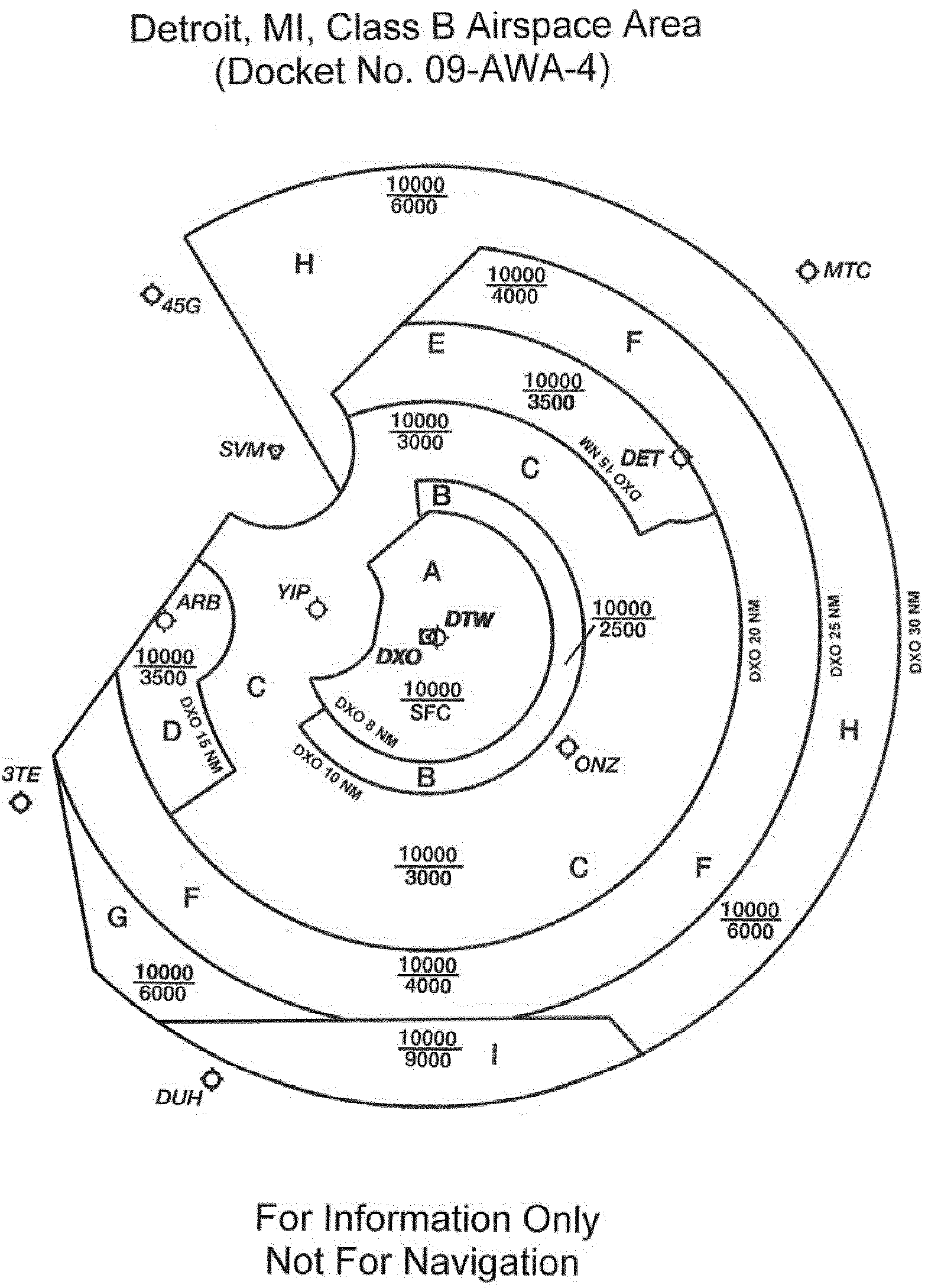
[FR Doc. 2012-19902 Filed 8-13-12; 8:45 am]
BILLING CODE C


Document Information
- Comments Received:
- 0 Comments
- Published:
- 08/14/2012
- Department:
- Federal Aviation Administration
- Entry Type:
- Proposed Rule
- Action:
- Notice of proposed rulemaking (NPRM).
- Document Number:
- 2012-19902
- Dates:
- Comments must be received on or before October 15, 2012.
- Pages:
- 48476-48491 (16 pages)
- Docket Numbers:
- Docket No. FAA-2012-0661, Airspace Docket No. 09-AWA-4
- RINs:
- 2120-AA66: Airspace Actions
- RIN Links:
- https://www.federalregister.gov/regulations/2120-AA66/airspace-actions
- Topics:
- Airspace, Incorporation by reference, Navigation (air)
- PDF File:
- 2012-19902.pdf
- CFR: (1)
- 14 CFR 71.1